Winter Storms
As the sun gradually lowers in the sky in the Northern Hemisphere during the fall, cold Arctic and polar air masses intrude farther and farther south into the United States. Disturbances forming along the boundary between the cold polar air and the relatively warm air to the south sometimes turn in to winter storms. These are usually large, intense low pressure systems that cover tens of thousands of square miles. The combination of snow, wind, and sub-freezing temperatures can cause major disruptions to transportation and commerce, and is dangerous for those not prepared for these weather conditions.
Winter storms in the Midwest can occur anytime from mid to late October well into April, but typically occur during the winter months of December through February. Winter storms can range from a snowfall over several hours to a blizzard with wind-driven snow that lasts for a day or more. The larger winter storms affect several states, while others, such as a lake-effect storm around the Great Lakes affect a relatively small area.
Winter Storm Hazards
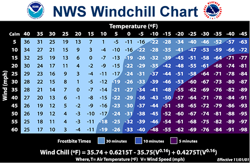
The components of severe winter storms expose us to a variety of potentially dangerous conditions. Heavy snow can paralyze surface and air transportation for days. High winds accompanying snow can make it difficult for road crews to keep highways clear. Winds and heavy wet snow or icing may bring down trees and power lines, leaving affected residents without heat. Cold temperatures present a risk for exposure and hypothermia for those caught outside and not properly dressed or prepared for such conditions. Every year, winter weather is responsible for the deaths of hundreds of people in the United States primarily from “indirect” causes - vehicle accidents, fires from improper use of heaters, overexertion, and exposure. Researchers say that 70 percent of the fatalities related to ice and snow occur in automobiles, and about 25 percent of all winter related fatalities are people that are caught off guard, out in the storm.
A blizzard is a severe winter storm defined as one with sustained winds or frequent gusts of 35 mph or greater, considerable falling and/or blowing snow frequently reducing visibility to less than ¼ mile, with these conditions lasting for a period of three hours or longer. In the central U.S. blizzards are most common in North Dakota, South Dakota, and western Minnesota. Although temperature is not one of the criteria for a blizzard, high winds and low temperatures with blizzard conditions may produce dangerous wind chill values.

Origin of Winter Storms

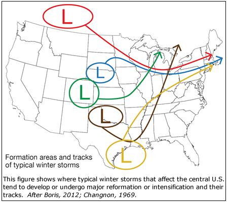
Winter storms tend to form where there are great contrasts in temperature. During the winter months the lee side of the Rockies and the western Gulf coast provide the battleground for these air masses. Most of the low pressure systems that become the large winter storms in the central U.S. form or redevelop in the lee of the Rocky Mountains. Sometimes weather systems will move in off of the Pacific, weaken as they cross the western U.S., and then re-intensify downwind of the Rockies. Favored areas for development include the Province of Alberta, Canada, just east of the Canadian Rockies; Colorado and the surrounding region; and the Texas Gulf Coast. Once the storms have developed, winds in the upper atmosphere determine exactly where and how fast they move.
Lake-Effect Storms
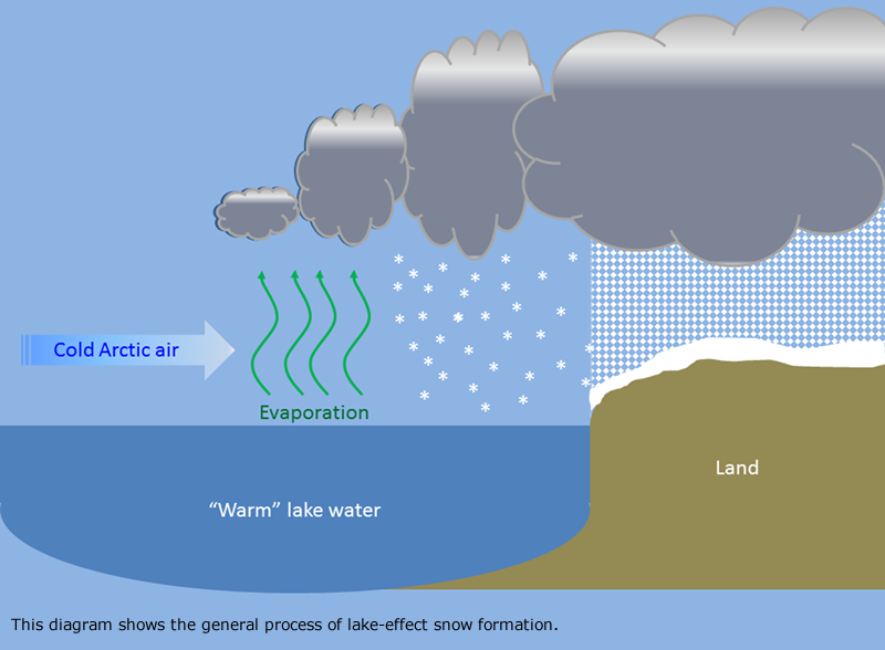
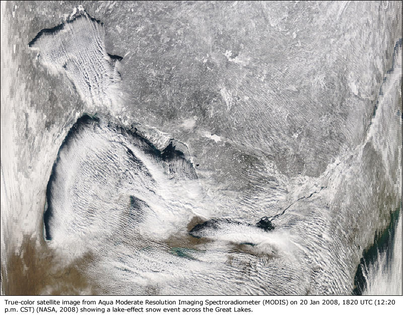
Lake-effect snow results when cold Arctic air moves across the warmer waters of the lakes (primarily the Great Lakes in the central U.S.). Lake-effect snows tend to occur earlier in the winter when the contrast between the air and water temperatures is greater, before the water cools and ice begins to form on the lakes. As the cold air moves over the warmer lake water it picks up heat and water vapor. The rising air forms clouds, and these snow-producing clouds then move over land.

Lake-effect snows tend to be the most extreme when the difference between the air temperature and lake temperature is high, and then winds are such that the cold air moves over as much water as possible.. The heaviest lake-effect snow typically falls only 5 to 10 miles inland, but can extend to as much as 50 miles. Snow can accumulate at rates as high as 2 feet a day and snow can continue for several days. High winds can result in dangerous whiteout conditions.

Staying Ahead of Winter Weather
The National Weather Service uses specific winter weather terms to ensure that people know what to expect with winter weather.
A Winter Storm Watch means that severe winter conditions, such as heavy snow and/or ice, may affect your area, but its occurrence, location and timing are still uncertain. A winter storm watch is issued to provide 12 to 36 hour notice of the possibility of severe winter weather. A winter storm watch is intended to provide enough lead time so those who need to set plans in motion can do so.
A Winter Storm Warning is issued when 4 or more inches of snow or sleet is expected in the next 12 hours, or 6 or more inches in 24 hours, or 1/4 inch or more of ice accretion is expected.
Winter Weather Advisories inform you that winter weather conditions are expected to cause significant inconveniences that may be hazardous. If caution is exercised, advisory situations should not become life-threatening.
A Blizzard Warning means that the following conditions are expected to prevail for a period of 3 hours or longer:
- Sustained wind or frequent gusts to 35 miles an hour or greater
- Considerable falling and/or blowing snow (i.e., reducing visibility frequently to less than ¼ mile)
Stay abreast of developing weather with NOAA Weather Radio .
Winter Precipitation
Snow
Precipitation of ice crystals, mostly branched in the form of six-pointed stars.
Snow Grains
Precipitation of very small, white, and opaque grains of ice, the solid equivalent of drizzle. They are flat and elongated, with very small diameters. They fall in small quantities, and never in the form of a shower. When these grains hit the surface, they neither bounce or shatter.
Snow pellets/graupel
White, opaque grains of ice, with diameters about 5 times the size of snow grains. The real distinction between snow grains and pellets is that snow pellets are brittle, crunchy, and bounce upon hitting a hard surface. Sometimes they will break on impact. Also, they fall in the form of showers, from mainly cumulus congestus clouds.
Ice Pellets
Commonly called sleet. Precipitation of transparent or translucent pellets of ice, which are round or irregular. Typically they are hard grains of ice consisting of frozen raindrops or largely melted and refrozen snowflakes.
Freezing Rain and Freezing Drizzle
Rain and/or drizzle that falls in liquid form and freezes upon impact, forming a glaze on the ground or other exposed objects.
Winter Weather Resources
FEMA web page on what to do before, during, and after winter storms and extreme cold .
National Weather Service Winter Weather Safety and Awareness page
US Fire Administration/FEMA Winter Storm Fire Safety
American Red Cross Winter Storm Preparedness information
Winter Storm Safety and Health Guide - OSHA
Winter, Your Car, and You - National Safety Council (pdf)
Ready.gov Kids Pages - Ready Kids!
Emergencies can be scary, but the more you know about them, the better you can deal with what comes your way! This
Ready.gov section also has games plus info geared toward parents and educators.
Ready Wrigley's pages at the CDC Office of Public Health Preapredness and Response
Ready Wrigley the dog has printable books, checklists and even an app to help your child learn and prepare for
disasters and weather events.
Climatology of Severe Winter Storms in Illinois . ISWS Bulletin 53. By Stanley A. Changnon, Jr., 1969. (pdf)
Major Winter Storms in the Midwest during Winter 2006-2007. Changnon, Stanley A. and Kenneth E. Kunkel., 2007 ISWS DCS 2007-04
MRCC Climatology References page: Snow Climatologies , Ice and Freezing Rain Climatologies
^Top