Military Forts and Voluntary Observers Database
Weather data from 450 US stations, operating from 1820 to 1892, were digitized, and over 350 of these stations underwent quality control with NOAA Climate Data Base Modernization (CDMP) funding. This website provides information about 19th-century forts and the Voluntary Observers database, known as FORTS data.
The U.S. Army forts recorded daily weather observations starting in the early 1800s. In the mid-to-late 1800s, volunteer observer networks were managed by the Smithsonian Institution and the U.S. Department of Agriculture. These station networks eventually evolved into the Weather Bureau's Cooperative Observer Network, which continues to collect data for the National Weather Service today.
These data connect recent instrument records and paleoclimate records, such as tree ring reconstructions. The National Archives and Records Administration houses records from the 1800s on microfilm. These records have been scanned and indexed and are available online through the National Center for Environmental Information (NCEI) and offline from the MRCC service office. For more information, please refer to the image inventory page.
Thirty-nine distinct data types were identified for digitization. These include various observations such as temperature, pressure, precipitation, wind, cloud cover, weather conditions, river gauge height, and surface water temperature.
To ensure accuracy, a series of quality quality control tests and procedures were applied to much of the digitized data confirming that it accurately reflects the observations recorded in the original documents.
A comprehensive set of metadata was created to enhance the data set. This metadata documents changes in instrumentation and observation practices by tracking modifications in the forms used by observers. It includes detailed information about each station, such as the station name, location, barometer corrections, and other instrument adjustments, whenever available.
The following is currently available through this website:
- A monthly inventory of all images by month and year available for each station, as available in the NOAA EV2 web archive, showing the extent and completeness of records for each station.
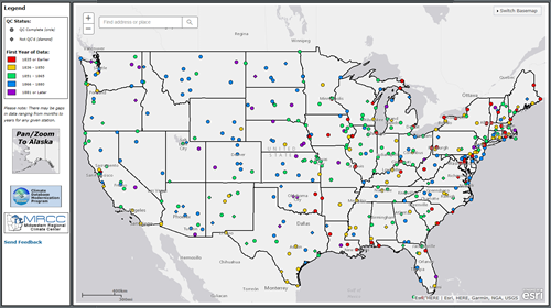
- A list of stations selected for keying the daily weather data shows the current status of the Project, including stations for which keying is complete.
- A list of stations indicating the completeness of keying and quality control and whether the data are available.
- A compilation of sample standard forms used in the 19th Century allows for searching based on desired weather observation types or periods.
- Observation histories for selected stations in PDF format. for selected stations in PDF format. These histories include maps of the observation stations, photos, illustrations, and a chronology of locations and elevations.
- Quality-controlled data by station can be obtained in the Forts Data 3200 format with all variables and also as two *.csv files. One file has daily temperature and precipitation variables only, and the second has a chronology of known station identifiers, locations, and observers.
Please contact the MRCC Service Office if you have questions or would like to obtain keyed quality-controlled FORTS data.