Thunderstorms

The Midwest is an area of the country that experiences thunderstorms regularly because the area is a battling ground
between warm, humid airmasses from the Gulf of Mexico and cold, dry airmasses from Canada. Thunderstorms can be
short-lived (30 minutes to 1 hour) single-cell storms, or can be an organized series of severe thunderstorms with
large hail, strong winds, and tornadoes that last many hours. Because of this, the Midwest has played, and continues
to play, a large role in the understanding of thunderstorms and severe thunderstorms. Notable thunderstorm research
contributions that have occurred in the Midwest include the Thunderstorm Project in Wilmington, Ohio, which was the first project to combine both radar
and aircraft observations, and observations of the first hook echo of a tornado captured on radar, identified in a thunderstorm in Champaign,
Illinois.
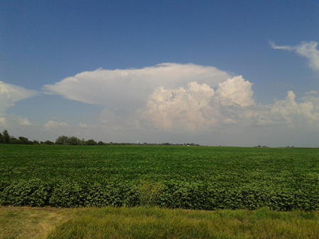
A thunderstorm over west-central Indiana. Photo courtesy of Steven Hilberg
Thunderstorm Environments
Thunderstorms are a common occurrence across the Midwest during late spring, summer, and early fall, The months of greatest activity are May through July when warm and moist maritime tropical airmasses collide with cooler and drier continental polar airmasses over the Midwest (figure 1). Thunderstorms can, however, develop during any month of the year. Thunderstorms develop whenever the atmosphere is unstable (when the air at the surface is warmer than air aloft), very moist, and when a lifting mechanism is present. Lifting mechanisms include solar heating (figure 2), a warm or cold front (figure 4), an outflow boundary, and in some regions, topography (figure 3).
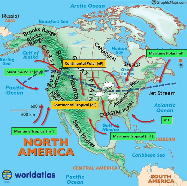
Figure 1. Airmass collision across North America and the United States.
Sources: Base map and
www.asu.edu for the graphic.
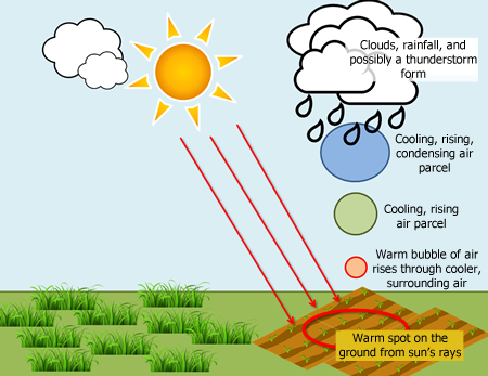
Figure 2. Diagram of solar heating of the ground leading to convective rainfall. Image by Olivia Kellner, Midwestern Regional Climate Center

Figure 3. An example of a warm, moist airmass running into a mountain barrier. The air mass is lifted over the mountain, and as it is lifted, the airmass cools, the water vapor condenses to form clouds and rainfall.
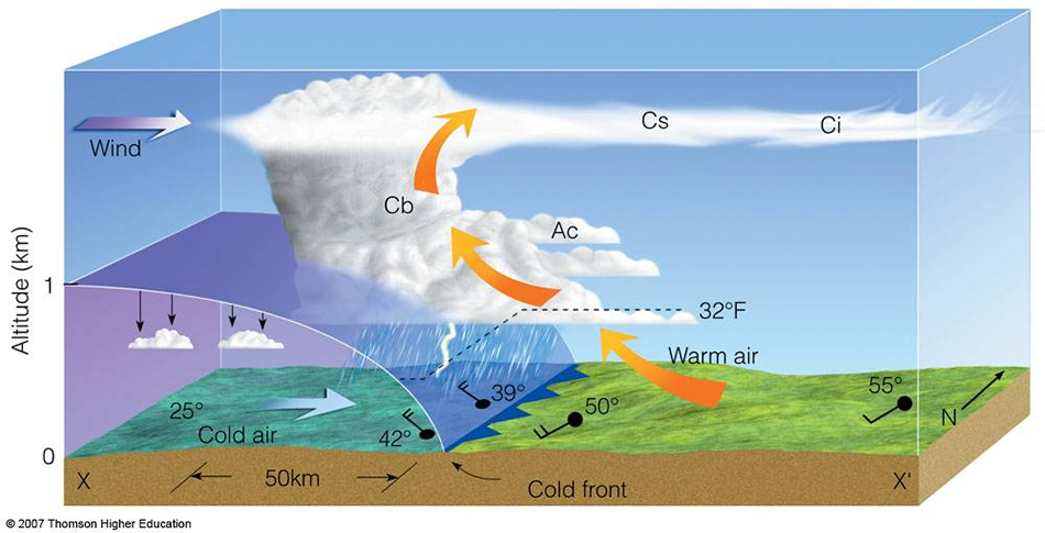 Figure 4. This diagram is a three-dimensional example of how a cold
airmass advances - lifting the warm and moist, less dense airmass over it - resulting in thunderstorms. The
“Cb, Cs, Ac, and Ci” denote specific types of clouds. The black circles with black lines extending
from with hatch marks are examples of surface weather observations. In this diagram they show temperature of the
air, and the direction and speed the wind is coming from.
Figure 4. This diagram is a three-dimensional example of how a cold
airmass advances - lifting the warm and moist, less dense airmass over it - resulting in thunderstorms. The
“Cb, Cs, Ac, and Ci” denote specific types of clouds. The black circles with black lines extending
from with hatch marks are examples of surface weather observations. In this diagram they show temperature of the
air, and the direction and speed the wind is coming from.
Source: Vermont
State Colleges
The more heat and moisture present in the atmosphere, the greater the chance of a thunderstorm becoming severe. A thunderstorm is considered severe if one or more of the following criteria are met:
- 1-inch diameter or greater hail
- 50 knots (57.5 mph) or greater wind gusts
- A tornado
The Thunderstorm Life Cycle
Thunderstorm clouds are easily distinguishable from other types of clouds because of their tall vertical dimension, and in their later stages, the presence of an anvil, where the top of the cloud extends horizontally away from the main cloud. Thunderstorms go through a life cycle of growth, beginning as a cumulus cloud, growing from cumulus congestus to cumulonimbus clouds (figure 5). As warm air continues to rise and condense in the cloud, heat is generated from the conversion of water vapor into water drops that form the cloud. As this heat is generated, the cloud grows stronger and larger and pulls air from the bottom of the cloud to the top of the cloud creating an updraft. The updraft pulls in more warm, moist air, helping the cloud grow taller. If the atmosphere near the surface has enough energy stored in it, the updraft can grow to be very strong and the cloud can grow up to 60,000 feet tall (as tall as 41 Empire State Buildings stacked on top of one another)! Once the updraft can no longer hold up the precipitation particles, these fall to the surface most commonly in the form of rain. The area of the storm where rain falls is called the downdraft. It is called a downdraft because a) air is being dragged downward from the falling precipitation, and b) the falling air is cooler and more dense than the surrounding air. This colder air is heavier than warm air in the updraft and the surrounding atmosphere so it sinks down towards the surface with rainfall – hence the name downdraft.
Once the storm has a downdraft, it is considered a mature thunderstorm and rainfall occurs at the heaviest rates. Downdrafts may also have very powerful winds. Once the downdraft dominates much of the storm cloud, and the updraft is no longer present to sustain the cloud with warm, moist air, the storm begins to fall apart or "dissipate." Rainfall begins to taper off and eventually the storm will end. This is known as the dissipating stage of the thunderstorm life cycle.
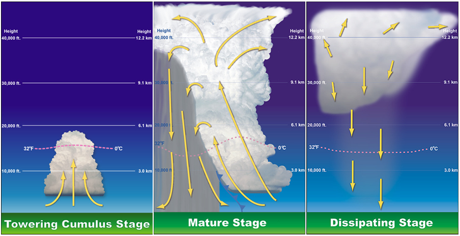
Figure 5. The life cycle of a thunderstorm. Source: NOAA Southern Regional Headquarters
Thunderstorm Types
Single cell air mass thunderstorms grow, produce rain with some gusty winds, lightning, and thunder, and die within about an hour (figure 6). They usually occur on summer afternoons resulting from daytime heating. When these storms grow above the freezing level, they become capable of producing lightning and thunder.
Multi-cell storms form in series when a single thunderstorm generates a gust front and the gust front triggers a new thunderstorm updraft (Figure 7). A gust front is the leading edge, at ground level, of the rain-cooled air generated from a single thunderstorm and acts like a small front surging outward from under the storm where rain is falling. The gust front then triggers new convection by lifting warmer, less dense air into the atmosphere. Each individual storm may last 30-60 minutes, but the entire line or group of storms may last for many hours. Multi-cell storms may produce hail, strong winds, brief tornadoes, and/or flooding.
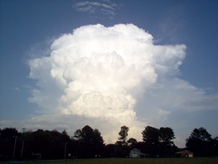
Figure 6. A single cell thunderstorm in its growing, towering-cumulus stages. Source: NOAA
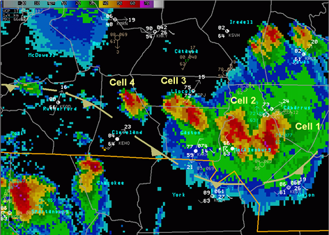
Figure 7. Radar imagery of multi-cell thunderstorms. In this case, they were severe thunderstorms. Source: Weather.gov
A squall line is a group of thunderstorms arranged in a line (Figure 8). They often form ahead of cold fronts associated with midlatitude low pressure systems, and bring along strong winds (also known as squalls) and heavy rain. However, squall lines can produce tornadoes. Tornadoes that form in a squall line are often weaker, short-lived tornadoes that spin-up quickly and are hard to detect on radar. On rare occasions stronger tornadoes of EF-3 intensity have occurred. Squall lines are typically hundreds of miles long but only 10 – 20 miles wide. Dramatic looking shelf clouds tend to form along the leading edge of a squall line.
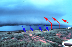
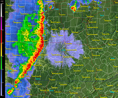
Figure 8. Left Photo: Shelf cloud. Red arrows denote upward motion of
air ahead of the shelf cloud. Blue arrows show the downward motion of air behind the shelf cloud. A shelf cloud suggests downdraft and outflow, and it moves away from the
precipitation area. Source: Photo courtesy of NSSL Photo library. Right Photo: Radar
imagery of a squall line. Source: NSSL Photo Library
Supercells are long-lived (more than 1 hour) thunderstorms. A supercell is an organized storm that occurs under very unstable conditions with strong surface winds from the south or southeast and upper level winds from the west or northwest (figure 9). The updraft in this type of thunderstorm is tilted and rotating. Rain falls ahead of the storm, outside of the updraft, preventing the storm from collapsing on itself. This is why supercells have a longer life cycle than a normal thunderstorm. Updrafts of supercells are commonly larger than a typical thunderstorm – as large as 10 miles in diameter and up to 60,000 feet tall. The rotating updraft of a supercell is called a mesocyclone. The mesocyclone is visible through the presence of a wall cloud. A wall cloud is where tornadoes most commonly form. Some people confuse wall clouds and shelf clouds. Shelf clouds form at the front of the storm before the rain. Wall clouds are at the back of the storm, under the rain-free base of the updraft.
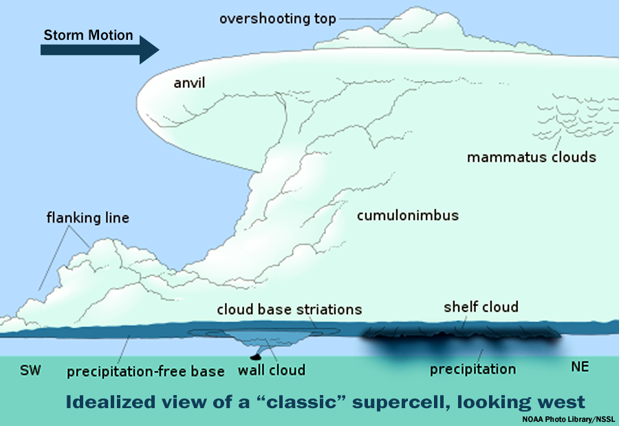
Figure 9. Diagram of a supercell thunderstorm. They are highly complex
single cell thunderstorms that commonly bring severe weather when they form. Source: NOAA Photo Library, National Severe Storms Laboratory
Thunderstorm Hazards
Below are two lists: one has the hazards associated with thunderstorms and the other is of hazards associated with severe thunderstorms. Many of these listed hazards are further explained in our other “Living with Weather” pages. The link for more specific information regarding each hazard is available next to the listed hazard.
The primary hazards of thunderstorms are:
- Heavy rain/flash flooding (see Living with Weather: Floods)
- Gusty winds (less than 57.5 mph)
- Hail (less than 1 inch) (see Living with Weather: Hail)
- Lightning (see Living with Weather: Lightning)
The primary hazards of severe thunderstorms are:
- Heavy rain/flash flooding (see Living with Weather: Floods)
- Strong wind gusts ≥ 57.5 mph
- Wind gusts can be further classified as one of the following severe weather wind phenomena (discussed in more detail below):
- Straight-line winds
- Microbursts
- Macrobursts
- Derechos
- Hail ≥ 1.0 inch (see Living with Weather: Hail)
- Tornado (see Living with Weather: Tornadoes)
- Lightning (see Living with Weather: Lightning)
Wind Hazards
Straight line winds are those winds associated with a thunderstorm that are strong enough to cause wind damage, but are not associated with rotation such as a tornado. They occur when there is a transfer of strong winds aloft down to the surface (Figure 10).
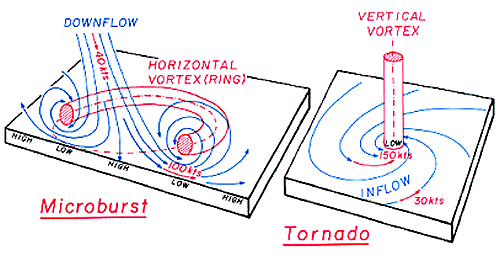
Figure 10. Wind motion comparisons between a microburst and tornado.
A downburst, as defined by Fujita (1985) and Wakimoto (1985), is a stronger-than-average downdraft of a thunderstorm. It is defined as a microburst or macroburst by the extent of land it impacts and how long the winds last.
- A microburst is a downdraft from a thunderstorm that has a concentrated impact of wind damage to an area less than 2.5 miles wide and peak winds lasting less than 5 minutes.
- A macroburst is a downdraft from a thunderstorm that has a concentrated area of wind damage across a larger area than a microburst. The area of damage is at least 2.5 miles wide or greater and peak winds last between 5 and 20 minutes. Strong macrobursts may cause wind damage equivalent to EF-3 intensity.
Because downbursts can have wind speeds as fast as a tornado, it is sometimes difficult for forecasters to determine if damage is from a tornado or a downburst. Aerial photography of wind debris helps storm survey personnel identify tornado versus downburst wind damage. Debris from down bursts blows outward from the base of the storm in a straight line (figure 11). Tornado debris is spread chaotically in a circular or spiraled pattern. Tornadoes pull air inward and upward into the base of the thunderstorm (figures 12 and 13).
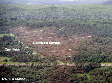
Figure 11. This image of downburst wind damage shows how a downburst
blows objects down in a fan-like manner. Trees in the middle are blown straight down while at the edges fan
outward. Source: Weather.gov
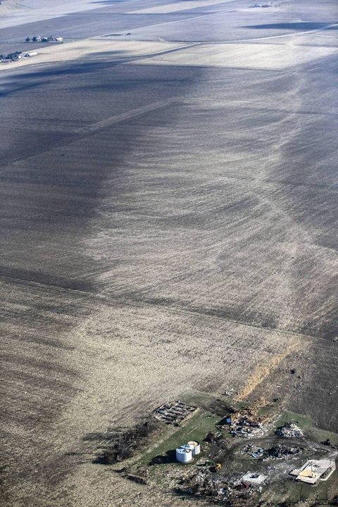
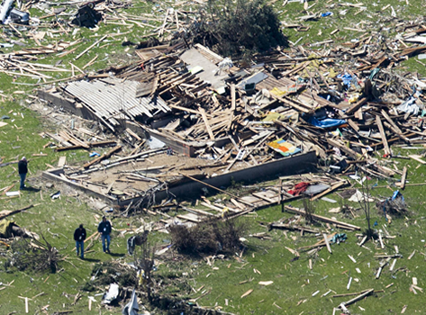
Figure 12. This image shows the circular winds associated with a tornado. This photo is from the Washington, IL tornado on Nov. 17, 2013.
Source: Chicagotribune.com
Fiture 13. This image shows tornado damage in north-central Illinois April 9, 2015. Tornadoes are whirling winds that scatter debris haphazardly but in a circular-like manner. Source: Chicagotribune.com
A derecho (pronounced day-RAY-cho) is a widespread, usually fast-moving windstorm associated with multi-cell thunderstorms or squall lines. Derechos include a family of downburst clusters produced by storms within a squall line, and derechos can produce damaging straight-line winds over areas hundreds of miles long and more than 100 miles across (figure 14). Storm Prediction Center (SPC) criteria for derecho classification is that the swath of wind damage extends for more than 240 miles, includes wind gusts of at least severe threshold criteria (57.5 mph) along most of the storm's length, and several, well-separated 75 mph or greater wind gusts.
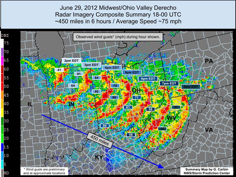
Figure 14. June 29, 2012 derecho across the Midwest. Image source: Globalnews.ca An article discussing this event can be found at the CoCoRaHS Blog.
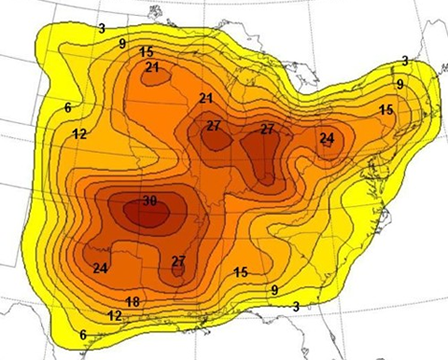
Figure 15. Map of approximate number of times moderate and high intensity derechos affected points in the United States 1980-2001.Source: NOAA Storm Prediction Center.
More information on derechos can be found at the following websites:
- Types of Derechos in the "About Derechos" page at the NOAA Storm Prediction Center website
- Frequently Asked Questions About Derechos
- More on the Climatology of Derechos in the United States
Historic Midwest Derecho (Thunderstorm Wind) Events
- June 29, 2012: This derecho event began in the afternoon on June 29, 2012 and continued through the evening and into the early morning hours of June 30, 2012. The total track length was approximately 800 miles beginning in eastern Iowa and ending on the East Coast. Peak winds of 91 mph were reported in Fort Wayne, Indiana. Hundreds of thousands lost power in Ohio, West Virginia, Virginia, Pennsylvania, Washington D.C., and Maryland (among other states).
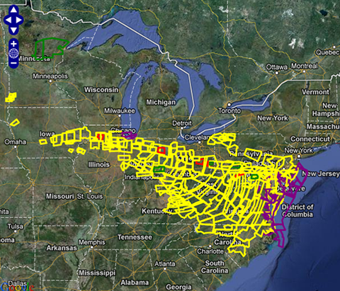
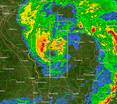
Figure 16. Left: Image capturing all of the severe thunderstorm
warnings associated with the derecho event that took place April 24-28, 2011. Source:
mesonet.agron.iastate.edu. Right: Super derecho as it formed an eye and resembled an
inland hurricane on May 8, 2009. Photo courtesy of NWS PAH.
- May 2009 Southern Midwest Derecho: a progressive derecho and mesoscale convective vortex that also generated 39 tornadoes. The initial system began as a cluster of thunderstorms that formed in northwestern Kansas overnight on May 7th, where over the next several hours it organized into a larger thunderstorm complex and into a derecho, as the storms entered a more favorable environment of moisture and winds that fueled the storm.
Thunderstorm Cloud Phenomena
The flow of wind around the storm and in a thunderstorm can lead to interesting clouds or optical phenomena. Common clouds or optical phenomena include mammatus clouds, shelf clouds, roll clouds, cold air funnels, a rain foot, and gravity waves.
Recognizing cloud types can help you know whether severe weather may or may not be in your area:
- Roll clouds, gravity waves, and cold air funnels are not commonly associated with severe weather hazards.
- Mammatus may or may not indicate severe weather as they can form with or without a severe thunderstorm.
- Shelf clouds, wall clouds, and rain foots more commonly develop with severe weather events.
- A fast-moving and well defined shelf cloud indicates strong winds
- A wall cloud suggests the potential for a tornado
- A rain foot is indicative of a wet micro or macrobursts
A roll cloud is a low, horizontal cloud that very much resembles a tube (figure 17). They appear to be rolling as they move across the sky, and are a result of a single wave of energy moving through the atmosphere that doesn’t change speed or shape. Such a wave of energy would be created by a thunderstorm downdraft. Unlike a shelf cloud, they are associated with a lake breeze, a sea breeze, or a cold front. Unlike a shelf cloud, they move ahead of their "parent" thunderstorm. They are rarer than shelf clouds, and are more commonly associated with a lake breeze, sea breeze, or cold front outflow.
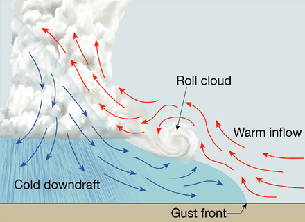
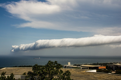
Figure 17. Left: How roll clouds form. . Source:
www.geography.hunter.cuny.edu Right: A photo of a roll
cloud. Source: www.earthtouchnews.com.
Gravity waves are invisible phenomena that become visible in clouds (figure 18). Gravity waves are generated when layers of the atmosphere separate because the layers are of different densities. When energy disrupts these atmospheric layers, the layers remain stacked on top of each other but take on a wave-like motion. The process is similar to dropping a stone in a puddle of water and watching the spreading ripples on the surface of the water. Gravity waves can be initiated by powerful thunderstorms.
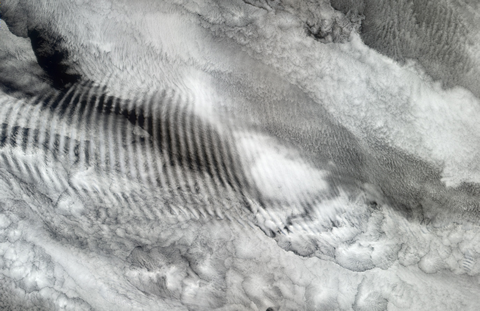
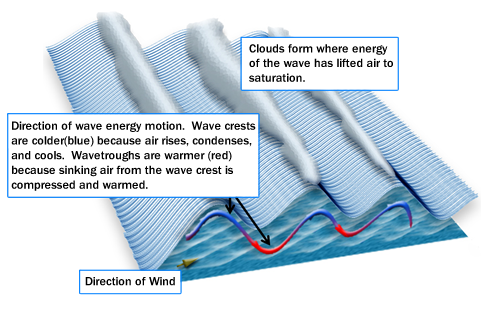
Figure 18. Left: A photo of gravity wave clouds from a satellite.
Source: earthobservatory.nasa.gov. Right: How gravity clouds are
generated. Diagram adapted from original at www.brockmann-consult.de/CloudStructures/ with explanations provided
by Dr. Olivia Kellner, MRCC.
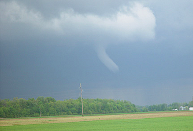
Figure 19. Photo of a cold air funnel near Wapokoneta, Ohio. Source: NWS ILN, taken by Troy Anderson, Auglaize County EMA
A cold air funnel is a funnel cloud that almost never touches down at the surface (figure 19). They are weak vortex circulations that form in cumulonimbus clouds with higher cloud bases (farther from the earth’s surface) in colder airmasses. The type of atmospheric environment that cold air funnels form in is rather benign (minimal instability and not favorable for rotating thunderstorms that produce tornadoes). They commonly form behind a cold front where enough instability still exists in the environment to produce towering cumulus clouds but little precipitation, and the large-scale environment is spinning due to a cold-core low pressure system in the upper levels of the atmosphere. Cold air funnels typically form in towering cumulus clouds that do not have mesocyclones, and therefore, do not have wall clouds.
Mammatus are a type of cloud that most commonly forms on the underside of a thunderstorm anvil (ice particles). They form when extremely moist air in the thunderstorm updraft loses its upward momentum and begins to spread out above the thunderstorm horizontally. The increased numbers of precipitation particles in the saturated air begin to sink back towards the surface through the surrounding drier air resulting in mammatus clouds (figure 20).
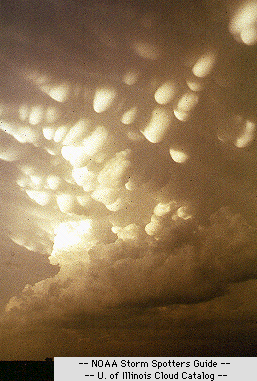
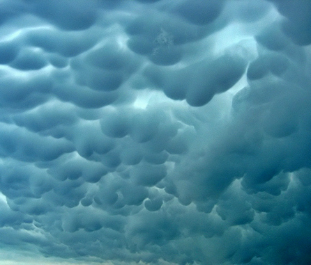
Figure 20. Photos of mammatus clouds. Left Source: University of
Illinois WW2010 project. Right Source: www.srh.weather.gov.
A shelf cloud typically forms on the leading edge of its “parent” thunderstorm outflow boundaries – where the cold air from the thunderstorm downdraft is surging ahead of the storm into warmer air (figure 21). A shelf cloud moves with the storm, and rising motion can be seen in the leading portions (outer portions) of the shelf cloud while the underside appears turbulent. If a gust front is strong, the leading edge of the shelf cloud may have a ragged appearance lined with fractus clouds that may also be complemented by vortices. These vortices, however, are not tornadoes.
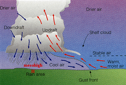
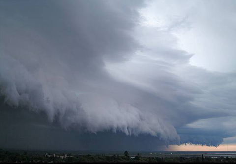
Figure 21. Left: How shelf
clouds form. Right: Example of a shelf cloud.
A wall cloud is a severe thunderstorm feature associated with a mesocyclone. A mesocyclone is a larger, established rotation present in the updraft of a supercell thunderstorm. Wall clouds are the area of the rain-free cloud base of a thunderstorm that is lower than the rest of the storm (figure 22). They denote where the strongest area of a thunderstorm updraft is occurring and where tornados are most likely to develop. (see “Living with Weather – Tornadoes”)
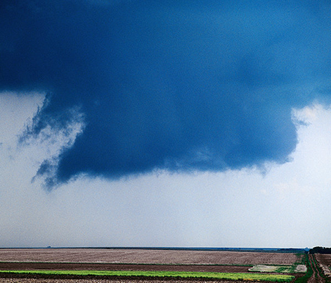
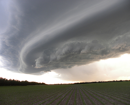
Figure 22. Photos of wall cloud examples. Left source: NWS JetStream -
Online School for Weather. Right source: NOAA Photo Library
A rainfoot tends to develop when a really strong downdraft (e.g. a microburst or a macroburst) is accompanied by heavy precipitation at the surface (figure 23).
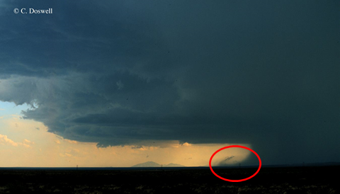
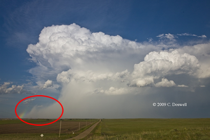
Figure 23. Photos of rainfoot examples, with rainfoot circled in red. Photos
courtesy Dr. C. Doswell.
Safety and Preparedness
Being prepared for a thunderstorm means being prepared for the different hazards associated with thunderstorms:
- Have a NOAA all-hazards weather radio available and turned on to receive the most timely and accurate watches and warmings of severe thunderstorms and associated hazards. NOAA weather radios are available from many retailers with a variety of functions and features. If you can not find one in your area, contact the National Weather Service office closest to you.
- Lightning safety can be reviewed in our Lightning Section
- Hail safety can be reviewed in our Hail Section
- Tornado safety and preparedness can be reviewed in our Tornadoes Section
- Flood safety for thunderstorms with heavy rainfall can be reviewed in our Floods Section
- Damaging wind safety includes seeking shelter in the center-most part of your house or in a basement, because micro and macro-bursts can have wind speeds as strong as some tornadoes!
Resources
There are many different types of thunderstorm hazards, several of which we discuss further in a number of “Living with Weather” pages - click on one of the icons at the top of the page to learn more!
Sources:
- Storm Prediction Center
- National Severe Storms Laboratory
- National Weather Service JetStream – Online School for Weather
- Severe Weather Facts & Myths from Weather.gov
- Ready.gov Kids Pages - Ready Kids! - Emergencies can be scary, but the more you know about them, the better you can deal with what comes your way! This Ready.gov section also has games plus info geared toward parents and educators.