Tornadoes

Perhaps no other weather phenomenon captures the attention of the public more than tornadoes. Tornadoes occur in many parts of the world and are not unique to North America and the U.S. However, the U.S. does top the list in absolute tornado counts with an average of over 1,000 tornadoes recorded per year. Canada is in second place with 100 tornadoes per year.
A tornado is a violently rotating column of air that is in contact with both the ground and a cumulonimbus cloud (thunderstorm) or, in rare cases, the base of a cumulus cloud. That column of rotating air may or may not be visible. Tornadoes become visible when water vapor condenses into a cloud and/or the tornado picks up dust and debris.
All thunderstorms do not produce tornadoes or severe weather. A number of atmospheric conditions need to exist at the same time to produce the intensity of thunderstorms that spawn tornadoes: abundant low-level moisture, atmospheric instability, and a mechanism to “lift” the air" such as a cold front or dryline, and strong winds aloft winds that turn with height in a clockwise, or veering, direction. This turning of wind direction with height is called vertical directional wind shear. Wind speeds increasing or decreasing rapidly with height is called vertical speed wind shear.
Low-Level Moisture
This is a key ingredient for thunderstorm formation. In the central U.S. the source of much of that moisture is the Gulf of Mexico. As the jet stream retreats northward in the spring warm, humid air masses can push into the south central and central U.S. You really notice the increased moisture in the air when the dew point temperature reaches the mid-60s, and the air becomes oppressive when the dew point temperature is in the 70s.
Atmospheric Instability
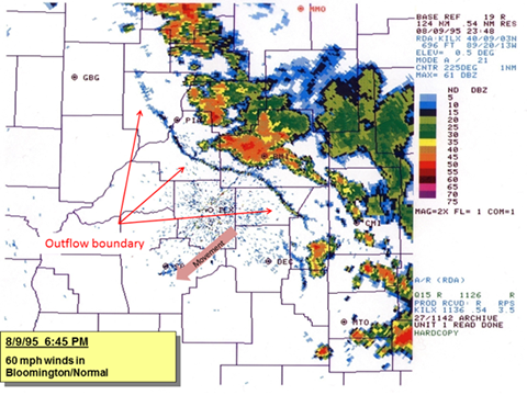
Radar image of thunderstorms generated by an outflow boundary. The thunderstorms to the northeast of the boundary developed as the boundary moved through and lifted the air near the ground, initiating convection. Credit: National Weather Service Lincoln, IL.
Lift
In order for clouds and thunderstorms to form, there needs to be a means to start air moving upward. On some days all that is needed is for the surface air temperature to be high enough and convection will begin. When the temperature needed to begin convection from the surface will not be reached, then some other means of lifting the air is needed. Cold fronts are a good means to start lift. The cooler, denser air hugs the surface and wedges under the warm layer of air ahead of it, forcing it upward. Dry lines, which separate warm, moist air from hot, dry air behave in a similar fashion. These are most common in the Central and Southern Plains. Another mechanism that helps lift air is outflow boundaries. An outflow boundary is the leading edge of a pool of cool air that radiates out from a thunderstorm.
Lift also occurs when there is convergence of the air, that is, where air coming from two opposite directions meets and is forced upward. An example of this is a lake breeze.
Wind Shear
Wind shear, the change of wind direction and/or speed with height is a key factor in producing severe thunderstorms that generate tornadoes. Vertical wind speed shear induces a "rolling" effect in the atmosphere. When a thunderstorm forms in such conditions this rolling effect causes the thunderstorm to rotate when it is tilted upward by the thunderstorm updraft. Directional wind shear causes the column of air to “twist” with height, aiding in rotation. The combination of strong speed and directional shear usually is supportive of supercells a thunderstorm that is characterized by a deep, persistently rotating updraft. Supercells are the type of thunderstorm most common in producing tornadic activity.
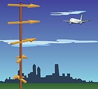
Directional shear occurs when the wind direction changes with height.
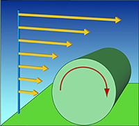
Vertical wind shear: as wind speed increases with height, the force of the wind causes the atmosphere to rotate on a horizontal axis.
Types of “Tornadoes”
In addition to the tornado there are a number of small cyclonic circulations associated with thunderstorms.
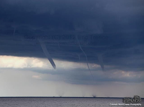
Five waterspouts at the same time and a funnel cloud over Lake Michigan. Photo courtesy of a Tweet by Eric Treece [@COLOStormChaser.] via NWS Sullivan, WI.
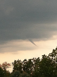
Funnel cloud near Grand Island, NE. Photo by David Radke via National Weather Service, Hastings, NE.
Landspout: A tornado not associated with a rotating thunderstorm (mesocyclone). Waterspouts and landspouts share many defining characteristics, including relative weakness, short lifespan, and a small, smooth condensation funnel which often does not reach the surface. Though usually weaker than classic tornadoes, they can produce strong winds which could cause serious damage.
 Landspout in Champaign County, IL on May 31,
2006.
Landspout in Champaign County, IL on May 31,
2006. Photo courtesy NWS Lincoln, IL
Gustnado: A small, vertical rotating column of air associated with a thunderstorm gust front or downburst. A gustnado will show circulation at the ground but not at the cloud base. They are formed when cold, dry outflow air from a thunderstorm is causes the air to roll, and if low level wind shear is strong enough, the rotation can be turned vertically or diagonally and make contact with the ground. They are not tornadoes because they are not connected to the cloud base, but can cause damage.
Gustnado in Jefferson County, KS on April 3, 2011. Credit:
Jefferson County Emergency Management and NWS.
Dust Devil: Rotating columns of air that form when hot air rises from the surface on a sunny, hot, calm day. If there is low-level wind shear the rising air can form a circulation that becomes a dust devil. Most dust devils are short-lived, but large ones can cause minor damage.
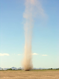
Dust Devil.
Cold air funnel: Cold air funnels develop in a cool air mass usually behind a cold frontal passage and often associated with a large low pressure system aloft. They often form beneath showers or weak thunderstorms when the air aloft at 15,000 to 20,000 feet is especially cold, while the low pressure system provides “spin” in the atmosphere. However, they can also develop below mid-level clouds that are not accompanied by precipitation. Cold air funnels rarely reach the ground.
Cold air funnel over central Illinois on August 14, 2012.
Climatology of Tornadoes
Tornadoes occur in many parts of the world, but nowhere are they more common than the United States. The reasons the U.S. and to a lesser extent Canada are prone to frequent tornadoes are geography and topography. In North America there is a relatively flat land mass extending from the sub-tropics to the Arctic. There is nothing to block the air masses originating from these regions from colliding with each other, thus making the U.S. and Canada conducive to the development of the strong thunderstorms that can spawn tornadoes.
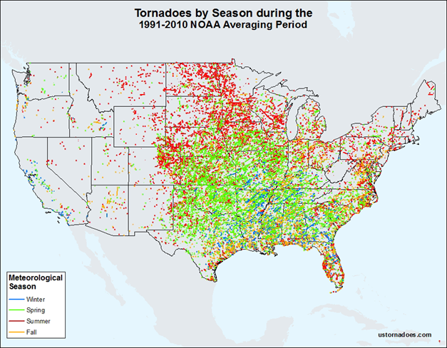
Tornadoes occur in all months of the year, but where tornadoes are most frequent changes with the seasons:
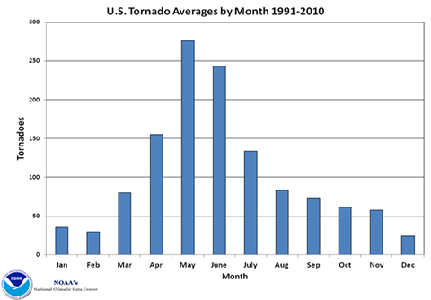
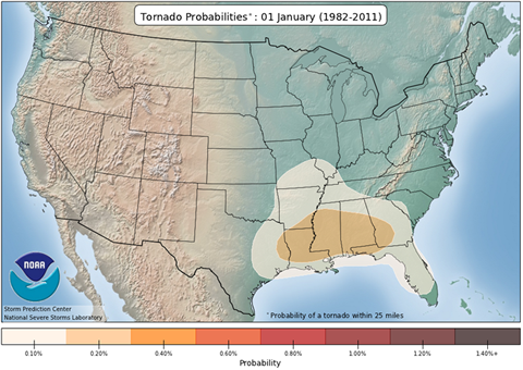
In early January, severe storms and tornadoes are most likely in the Gulf States where warm, moist air from the Gulf often clashes with the winter cold air masses spilling from the north, but overall the risk of a tornado is not that high (below left).
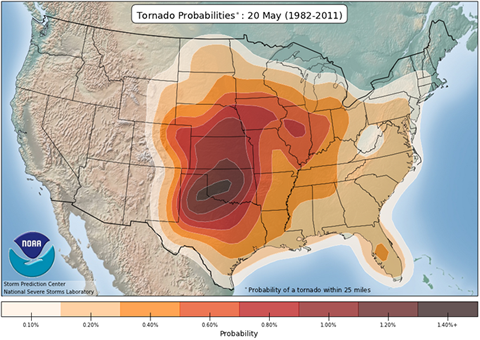
As the season transitions from winter to spring and the jet stream begins its northward retreat, the probability of tornadoes rapidly increases (below right). The retreating jet stream allows warm humid air to flow further north, while cold air masses are still able to dive into the middle of the country. This focuses the highest probabilities in the Southern and Central Plains, peaking in mid to late May.
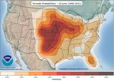
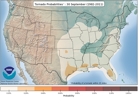
By mid-June the higher probabilities have shifted further north in the Central and High Plains (below left). The probabilities of tornadoes then begins a slow decrease through the summer and early fall, reaching a low point in late September (below right).
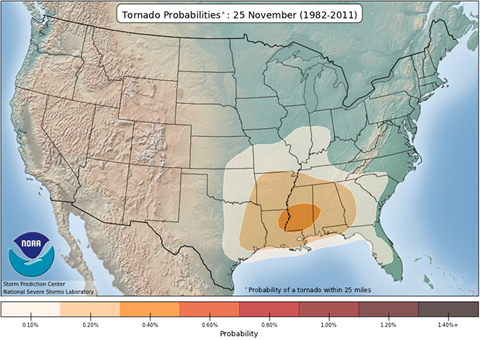
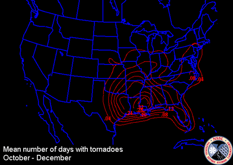
There is a secondary peak in mid- to late-November in the southern states, and probabilities then decline through December into January (below).
“Tornado Alley”
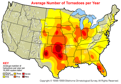
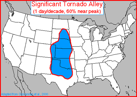
There are two regions in the U.S. that exhibit a high frequency of tornadoes. “Tornado Alley” is a nickname given to an area in the southern plains of the central United States that consistently experiences a high frequency of tornadoes each year (below left). The term was coined in 1952 by two Air Force severe weather forecasters, Major Ernest J. Fawbush and Captain Robert C. Miller, who four years earlier issued the first tornado forecast. “Tornado Alley” extends north from northern Texas through Oklahoma, Kansas, Nebraska, into the eastern half of South Dakota and western Iowa, and east as far as Illinois and Indiana. Most of the tornadoes in this area occur in the spring and summer.
Credit: National Severe Storms Laboratory
Credit: National Centers for Environmental Information (NCEI)
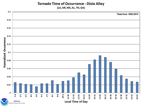
There is a second area of increased frequency of tornado across the southern U.S. This area, dubbed the “Dixie Alley” (above right), extends from eastern Texas eastward through Alabama, and tornadoes here tend to reach a peak frequency from October through December. Florida also has numerous tornadoes due to the high frequency of thunderstorms throughout the year.
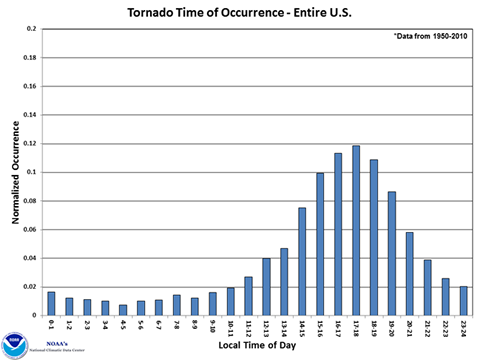
Time of Day
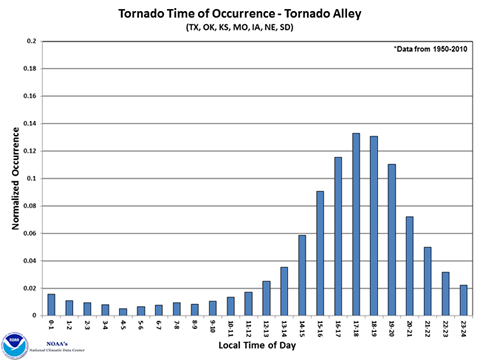
Tornadoes have and do occur at any time of the day or night, but there is a preferred period for tornado occurrence. Thunderstorms that produce tornadoes tend to occur during the afternoon and evening when the maximum heating of the atmosphere occurs. The least likely time for a tornado is the early morning hours around dawn when temperatures are typically at their lowest of the day. Nighttime tornadoes can be particularly dangerous because they are hard to visually confirm. Late at night residents of communities may be sleeping and have little time to react to a warning.
Tornado Severity
The intensity of tornadoes is rated by the damage a tornado causes and from the damage a wind speed range can be inferred. Dr. Ted Fujita introduced the Fujita Scale (F Scale) in 1971 which rates tornadoes based on damage to structures and vegetation and tornado path length. F0 is the weakest rating indicating a tornado producing “light damage”, and F5 the strongest rating with “incredible damage”, i.e. total destruction. The F Scale was updated in 2007 to the Enhanced Fujita Scale. This EF Scale was developed to reflect better findings of tornado damage surveys and to align wind speeds more closely with associated storm damage. Most significantly, the EF Scale expands on the degrees of damage and accounts for variables like quality of construction and prior condition of a structure. It is more objective and easier to use in its application than the original F Scale. The development of the EF Scale was a collaborative effort between meteorologists and civil engineers. A comparison between the F Scale and the EF Scale can be found here. Note that a rating can be assigned to a tornado only AFTER it occurs.
In the United States, 80 percent of tornadoes are EF0 and EF1tornadoes, and less than one percent are violent (EF4 and EF5) tornadoes.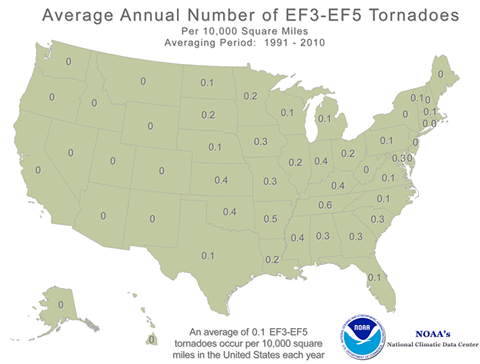 Average annual number of strong to violent
tornadoes (EF3-ER5) for the period 1991-2010.
Average annual number of strong to violent
tornadoes (EF3-ER5) for the period 1991-2010. 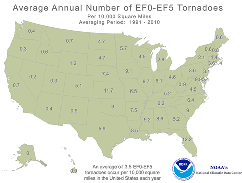 Average Number of all tornadoes for the
period 1991-2010.
Average Number of all tornadoes for the
period 1991-2010. Detection of Tornadoes
Advances in weather radar technology in the past 40 years have greatly improved our ability to detect potential tornado formation. The classic “hook echo” was first documented in 1953 in central Illinois by the Illinois State Water Survey. In the 1970s a scientist at NOAA’s National Severe Storms Laboratory discovered the Tornado Vortex Signature (TVS) in Doppler radar data. Further work eventually led to the deployment of Doppler weather radar throughout the country.
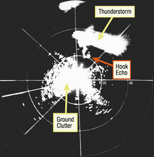 The first hook echo identified and photographed on radar taken on April 9, 1953 near Champaign,
IL. Credit: Illinois State Water Survey.
The first hook echo identified and photographed on radar taken on April 9, 1953 near Champaign,
IL. Credit: Illinois State Water Survey.Prior to the development of Doppler weather radar forecasters relied heavily on storm spotters for reports of tornado formation. Doppler weather radar detects circulation at some height above the ground, which increases with increasing distance from the radar due to the angle of the radar beam. Therefore storm spotters are still a critical part of the warning process. Forecasters rely on storm spotters for “ground truth”, to spot and confirm tornadoes and related storm features that cannot always be detected by radar. If you are interested in becoming a storm spotter contact your local National Weather Service office or visit the National Skywarn page.
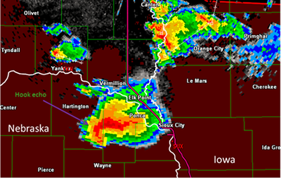 Radar image of a classic hook echo with a tornadic thunderstorm in eastern Nebraska on June 17,
2014.
Radar image of a classic hook echo with a tornadic thunderstorm in eastern Nebraska on June 17,
2014.The use of both improved Doppler radar technology and trained storm spotters has increased the average lead time of a warning to 13 minutes. However, each storm has its own set of unique circumstances and lead times are shorter or longer depending on the situation.
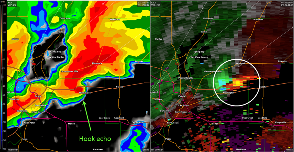
This is a side-by-side
image of the radar reflectivity (left) and the storm relative velocity at 11:07 a.m. CST on November 17,
2013 in central Illinois. At this time a large tornado was on the ground and barreling through
Washington, IL. The white circle in right image indicates the winds in the storm. Reds and yellows are
winds moving away from the radar, and blues and greens are winds moving toward the radar. When these
colors are seen adjacent to each other it indicates rotation. This image is showing extremely strong
rotation with winds in excess of 80 knots inbound and outbound. The NWS Lincoln, IL radar is located
about 36 miles south of the storm.
Tornado Preparedness and Safety
Be Weatherwise – Know What’s Going on
The National Weather Service’s Storm Prediction Center (SPC) has responsibility for monitoring the potential for and forecasting of severe weather for the entire United States 24 hours a day, 7 days a week. Each day the SPC issues Convective Outlooks which outline the potential for severe weather for one to eight days out. These outlooks describe the possibility for severe weather using five categories of risk for days 1-3: Marginal, Slight, Enhanced, Moderate, and High. For days 4-8 the outlooks indicate where and on what day(s) there is a 30 percent of a severe thunderstorm within 25 miles of a point.
When atmospheric conditions favor the development of severe storms and tornadoes the SPC will issue a Tornado Watch. The Watch means that tornadoes are possible in your area. You should pay attention to the weather and remain alert for the development of storms. A Tornado Watch is typically for a large area (multiple counties in one or more states) and for long periods of time, typically 4 to 6 hours.
A Tornado Warning is issued by your local National Weather Service office when a tornado has been sighted or indicated by weather radar - it is time to take cover! A Tornado Warning is issued for an area (counties or parts of counties) in the storm’s path, and is typically issued for a period from 30 to 60 minutes.
Every home should have a NOAA All Hazards radio! A weather alert radio will notify you of watches and warnings issued for your area. These are particularly useful indoors in both homes and businesses. Outdoor warning sirens are not intended nor designed to warn people indoors!Tornado Safety
When a tornado warning is issued you should be prepared to take cover immediately.
Indoors:
- Abandon mobile homes — they are not safe even when tied down. Go to a designated shelter
- Go to a basement or interior room on the lowest floor (bathroom or closet without windows, under stairs).
Get under a sturdy piece of furniture. - Cover yourself with a mattress or blanket
- Put on sturdy shoes
- Put infants in car seats (indoors!)
- If you have time, gather prescription medications, wallet and keys
- DO NOT open your windows!
In a vehicle:
- Leave the vehicle for sturdy shelter or drive out of the tornado’s path perpendicular to the tornado’s path, if possible.
- DO NOT hide under overpasses — they provide no shelter.
- Lie flat in a ditch (last resort).
Outdoors:
- Find a culvert or cave.
- Find something to hang onto.
- Lie flat in a ditch.
- Cover your head.
It is not advisable to leave shelter and try to drive away from an approaching tornado. Tornadoes can change direction suddenly, and you may find yourself unable to avoid the winds, debris, and hail. Congestion on area roads and highways can slow or stop your movement and leave you vulnerable to the approaching storm.
The American Red Cross has some excellent information on tornado preparedness and safety. The Federal Emergency Management Agency (FEMA) has information on building a safe room for your home or small business.
Tornado Safety Myths
There are a number of myths about tornado safety that have been proven to be wrong. Here are the most infamous of those.
“Opening windows will equalize pressure.”
If a tornado is heading for your home airborne debris will likely “open” windows long
before pressure would have any effect. Taking time to needlessly open windows is time you should be taking to get to
shelter.
“Go to the southwest corner of your basement.”
This myth arose from the belief that tornadoes generally move from southwest to northeast. In
fact, tornadoes can move from any direction. The safest place to be is in the basement, away from windows under a
staircase, sturdy piece of furniture, or under a mattress.
“When in a vehicle the safest place to take shelter is under a bridge or
overpass.”
Vehicles in general are potential death traps in a tornado because they can easily be picked up
and destroyed. Winds can funnel debris under an overpass or strong winds can blow you out from under and into the
tornado. There is also a risk of damage to the bridge and it collapsing.
“Tornadoes are affected by terrain. They never cross hills, rivers, or
mountains. “
There have been many examples of tornadoes cross rivers, moving through canyons, including one
which crossed the Continental Divide in 1987.
“Tornadoes avoid major cities.”
Residents of St. Louis, Salt Lake City, Memphis, Miami, Dallas, Atlanta, and Oklahoma City would
disagree. There is nothing about cities that prevents a tornado from rolling through them. Large buildings and
skyscrapers would have no effect. The fact is that cities occupy a relatively small amount of area compared to the
state they are in or the entire country, so the probability of a tornado hitting a major city is rather small.
Tornado Resources
- NOAA National Severe Storms Laboratory Severe Weather 101 – Tornadoes
- MRCC Tornado Tracks Tool
- National Centers for Environmental Information Tornado Climatology
- Interactive severe weather climatology maps – NOAA Storm Prediction Center
- The Storm Prediction Center Online Tornado FAQ
- The Enhanced Fujita Scale (EF Scale)
- The Tri-State Tornado Web Site (NWS/NOAA)
- Tornado Climatology References
- Societal Impact studies
- Rebuilding Hope After a Natural Disaster
- Ready.gov Kids Pages - Ready
Kids!
Emergencies can be scary, but the more you know about them, the better you can deal with what comes your way! This Ready.gov section also has games plus info geared toward parents and educators. - Ready Wrigley's pages at the CDC Office
of Public Health Preapredness and Response
Ready Wrigley the dog has printable books, checklists and even an app to help your child learn and prepare for disasters and weather events.