Ag Climate Dashboard: State Resources

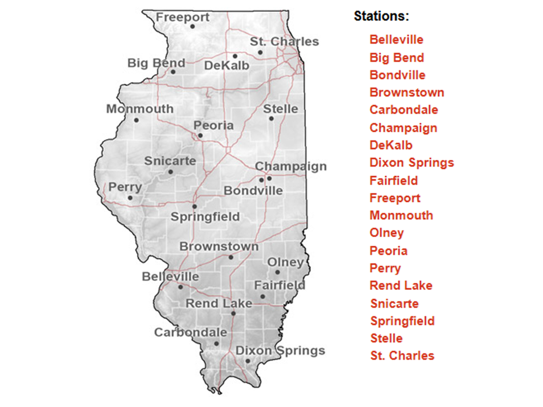
Illinois Climate Network (ICN)
Statewide agricultural and environmental monitoring
The Illinois Climate Network (ICN) is a system of automated weather stations managed by the Illinois State Water Survey. These stations collect real-time data on weather and soil conditions, such as temperature, humidity, wind, precipitation, and soil moisture and temperature, across the state. The information supports agriculture, research, and environmental monitoring by providing accurate, up-to-date weather trends. Data from the ICN are publicly available and widely used for crop management, climate studies, and resource planning, making it an essential tool for Illinois farmers, researchers, and policymakers.
- Soil and atmospheric real-time data
- Daily GDD accumulations
- Daily Pest Degree Day calculators
Illinois State Climate Office
Illinois' leader in climate science and outreach
The Illinois State Climate Office is the official source for climate science expertise in Illinois. The office conducts research, monitors weather and climate conditions, preserves historical climate records, and provides education and outreach to the public, policymakers, and various stakeholders. Its work includes analyzing long-term climate trends, responding to extreme weather events, and supporting decision-making across sectors with reliable climate data and insights.
- Recent climate summaries
- Climate event analyses
- State-based climatologies

Purdue Mesonet
High-frequency weather and soil data for ag and research
The Purdue Mesonet is a statewide network of automated weather stations throughout Indiana that provides real-time and historical weather data, as well as soil temperature and moisture, via its Data Hub. Users can access weather conditions statewide, view data on a map, and retrieve records ranging from 5 minutes to monthly in both graphical and tabular formats. This makes it a valuable resource for researchers, farmers, and anyone interested in Indiana’s weather trends.
- Station-based dashboard for local weather and soil monitoring
- Temperature inversion monitoring
- Daily Potential Evapotranspiration (PET) estimates

Indiana State Climate Office
Indiana’s primary resource for climate data and services
The Indiana State Climate Office at Purdue University serves as the state's official climate resource, offering weather and climate data, maps, and tools tailored for Indiana. It aids agriculture, emergency preparedness, and public safety by providing resources, newsletters, and resources focused on drought, climate trends, and state-based climatologies, enabling stakeholders to make informed decisions statewide.
- Seasonal newsletters promoting various climate resources
- Leader of the Purdue Mesonet, which provides state weather data
- Temperature, precipitation, and GDD maps

Indiana Water Balance Network
Tracking Indiana's water resources
The Indiana Water Balance Network (IWBN) is a statewide system of monitoring sites established to track long-term trends in Indiana’s hydrologic cycle, including near-surface atmospheric conditions, soil moisture, and groundwater levels. Launched in 2012, the network collects continuous data from wells and other sensors to help evaluate and manage the state’s water resources for agriculture, industry, and municipal needs. The IWBN supports research and decision-making by providing essential data for understanding water availability and trends across Indiana.
- Groundwater, soil moisture, and atmospheric data
- Operated by the Indiana Geological and Water Survey
- Station-specific dashboard

Iowa Environmetal Mesonet
Comprehensive environmental data hub operated by Iowa State University
The Iowa Environmental Mesonet (IEM) is a project of Iowa State University's Department of Agronomy, serving as a central data repository and service platform for environmental monitoring networks across Iowa and the Midwest. The IEM collects, archives, and disseminates real-time and historical data from a wide array of sources, including automated weather stations, airports, river gauges, and other federal, state, and local networks.
- Provides real-time and historical weather, soil, and hydrological data
- Interactive maps, dashboards, and data visualization tools
- Ag tools, severe weather, climate summaries, custom data downloads
Iowa State Climatologist
Official climate data and analysis for Iowa
The Iowa State Climatologist, part of the Climatology Bureau within the Iowa Department of Agriculture and Land Stewardship, provides expertise on Iowa’s weather and climate by compiling and analyzing climate data, preparing weekly and monthly weather summaries, and offering historical context for current events. The office supports agriculture, research, and public safety by conducting climate assessments, engaging in outreach, and collaborating with agencies like the National Weather Service, making reliable climate information accessible to Iowans statewide.
- Statewide climate monitoring and reporting
- Access to historical and current climate records
- Decision support for ag and policy planning

Kentucky Mesonet
High-density network for ag, safety, and research
The Kentucky Mesonet is a statewide network of over 70 automated weather and climate monitoring stations operated by the Kentucky Climate Center at Western Kentucky University. Established in 2007, it provides real-time, high-resolution data on temperature, precipitation, wind, humidity, solar radiation, and soil conditions, supporting agriculture, emergency management, research, and public safety across Kentucky. As the official source for climatological observations in the state, the Mesonet delivers critical information to the public, media, and agencies, enhancing weather forecasting and helping communities better understand and respond to Kentucky’s diverse weather patterns.
- Statewide climate maps
- Camera images for vegetation monitoring
- Soil temperature, moisture, and low-level temperature inversions
Kentucky Climate Center
Official state climate office for Kentucky
The Kentucky Climate Center (KCC), based at Western Kentucky University, is the state’s official climate office, responsible for collecting, analyzing, and sharing weather and climate information across Kentucky. KCC leads research, education, and outreach in partnership with government agencies, universities, and private organizations, supporting a wide range of sectors including agriculture, emergency management, public health, and transportation. The Center operates the Kentucky Mesonet, a statewide network of automated weather stations, and provides real-time, quality-controlled data to help mitigate the impacts of severe weather and inform decision-making.
- Statewide climate data and research
- Educational and outreach activities
- Operates the Kentucky Mesonet
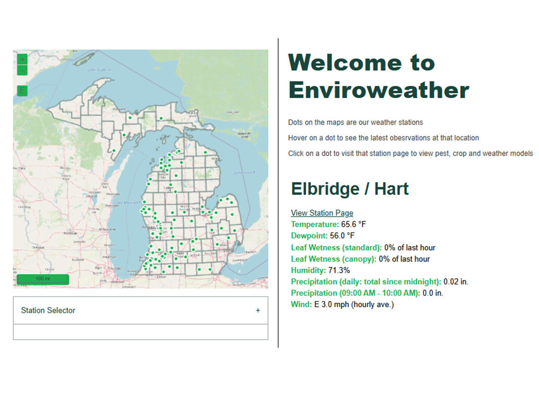
MSU Enviroweather
Statewide weather monitoring and tools for Michigan
MSU Enviroweather is a network of over 100 automated weather stations throughout Michigan and Wisconsin that collect real-time environmental data to support agriculture and gardening. The system offers free online tools and models for tracking weather, predicting pest and crop development, and managing plant diseases, assisting users in making informed, location-specific decisions. Enviroweather’s data and resources are utilized by growers, researchers, and gardeners to enhance crop management and respond proactively to changing weather conditions.
- Dense station network
- Real-time surface and soil data
- Crop-specific ag climate tools
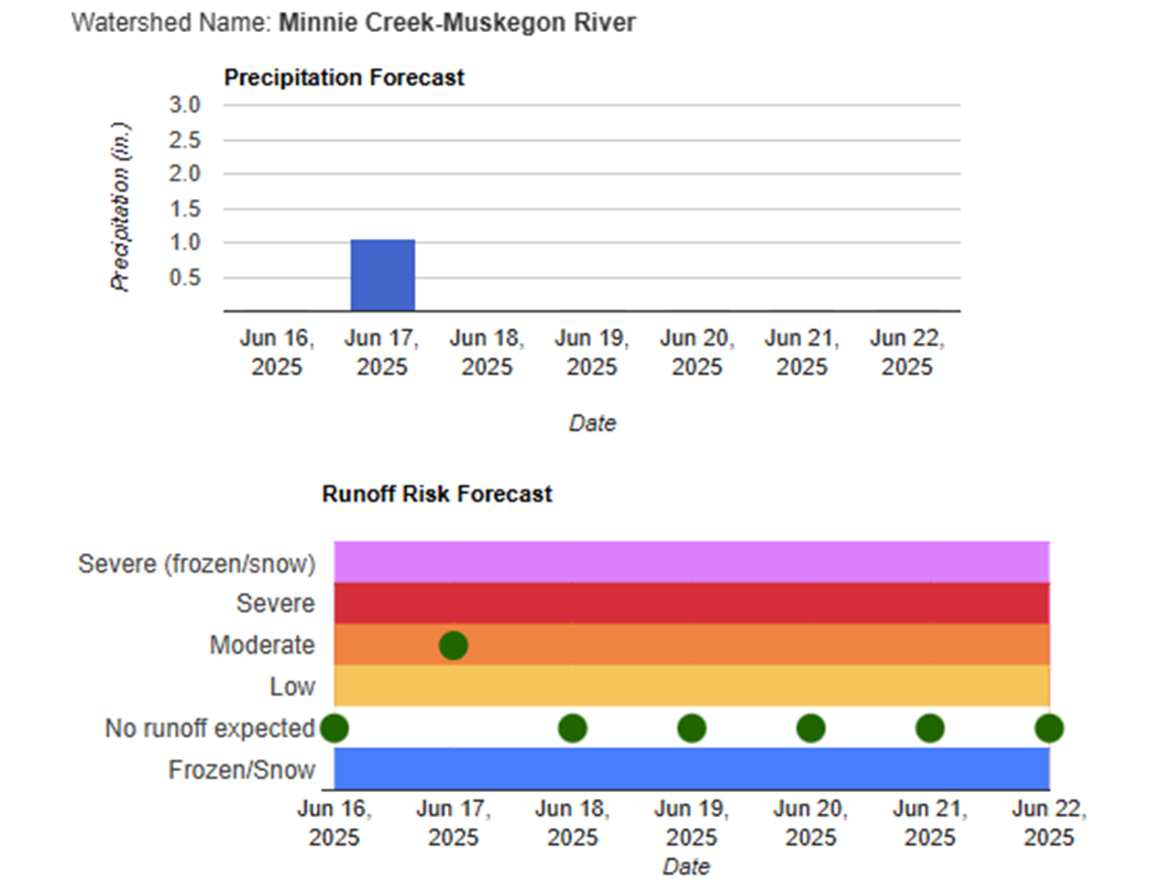
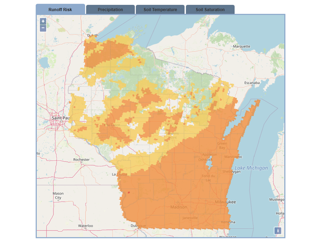
MI EnviroImpact: Runoff Risk
Michigan's essential decision-support tool for safe manure application and water quality protection
The Michigan EnviroImpact Tool is a free, interactive resource for farmers, commercial applicators, and land managers to determine the safest times for manure and fertilizer application, minimizing nutrient runoff and protecting Michigan’s water resources. It uses real-time data from the National Weather Service, including precipitation, temperature, soil moisture, snow accumulation, and landscape characteristics, to predict daily runoff risk across the state. Users can access color-coded maps, zoom into fields, and receive site-specific email or text alerts. The tool is advisory, not regulatory, supporting local knowledge and nutrient management plans. It is especially valuable for protecting the Great Lakes by reducing nutrient runoff during high-risk periods.
- Interactive maps show daily runoff risk (none, low, moderate, severe) for every part of Michigan, updated each morning
- Forecasts incorporate precipitation, temperature, soil moisture, snow cover, and landscape characteristics to assess short-term runoff risk
- Users can create free accounts to save fields, set up custom alerts, and manage risk notifications for specific locations
- Educational resources and best practices for responsible manure application

Minnesota Ag Weather Network
Statewide network for ag and climate monitoring
The Minnesota Ag Weather Network (MAWN) is a growing system of weather stations across central and northwestern Minnesota, managed by the Minnesota Department of Agriculture and partners. Currently featuring 38 stations, MAWN provides real-time weather and crop water use data to support agricultural producers and researchers. With recent funding, the network is expanding statewide, aiming to place a weather station within 20 miles of most farm areas and ultimately reach about 80 stations, improving local access to accurate weather information for better water and crop management.
- Weather data and soil temperatures
- Regional maps of weather data
- Ag-specific decision tools
Minnesota State Climatology Office
Tracking and interpreting Minnesota’s climate
The DNR State Climatology Office oversees, evaluates, and shares data and resources regarding Minnesota's historical climate. Part of the Minnesota Department of Natural Resources, this office operates within the Ecological and Water Resources division at the University of Minnesota's Department of Soil, Water, and Climate. The office helps clients understand how climate influences various aspects of the natural environment and socioeconomic activities. Users access climate monitoring tools to evaluate weather conditions and place them in a historical and geographical context. Additionally, they provide statistical summaries of past climate conditions, assisting users in making informed decisions for future endeavors.
- Statewide climate monitoring
- State-specific ag decision support tools
- Timely climate summaries

Minnesota Runoff Risk Advisory Forecast
Minnesota’s essential decision-support tool for safe manure application and water quality protection
The Minnesota Runoff Risk Advisory Forecast (RRAF) is a free tool developed by the Minnesota Department of Agriculture and the National Weather Service to help farmers and land managers determine safe times to apply manure and nutrients, reducing runoff risk and protecting Minnesota’s water resources. RRAF uses real-time weather and hydrologic models to assess runoff risk based on forecasted precipitation, temperature, soil moisture, snow accumulation, and snowmelt. It provides a color-coded map updated twice daily, showing the likelihood of runoff events for the current day, the next day, and a 72-hour period. The RRAF is advisory and not regulatory, complementing local knowledge and nutrient management plans.
- Interactive maps display no, low, moderate, and severe runoff risk for every part of Minnesota, updated twice daily
- Forecasts incorporate precipitation, temperature, soil moisture, snow cover, and local watershed characteristics
- Options to receive text or email alerts for severe runoff risk in your county
- Educational resources and best practices for responsible manure application

Missouri Mesonet
Comprehensive real-time and historic data for Missouri
The Missouri Mesonet is a statewide network of weather stations managed by the University of Missouri Extension and Missouri Climate Center, providing real-time and historical weather data for locations across Missouri. The network offers detailed information on current conditions, soil temperatures, and weekly weather summaries, supporting agriculture, research, and public safety by making reliable climate data accessible for counties throughout the state.
- Real-time maps
- Weather data and soil temperatures
- Weekly and monthly summaries by station
Missouri Climate Center
Tracking and interpreting Missouri's climate
The Missouri Climate Center, located at the University of Missouri, is the state’s official climate office. The Center develops and maintains advanced databases on Missouri’s weather, climate variations, and ecosystem changes, and produces valuable climate products for users statewide. It provides climate monitoring, along with historical and current data, and expert analysis to support agriculture, research, emergency management, and public decision-making throughout the state.
- Statewide climate monitoring
- Climate maps
- Decision support tools
Ohio Mesonet
Real-time weather and soil monitoring for Ohio
The Ohio Mesonet is a developing network of automated, research-grade weather stations designed to address gaps in weather observations across Ohio. Managed by Ohio State University and supported by partners like the Ohio Soybean Council, the network provides high-quality, real-time data on temperature, moisture, wind, solar radiation, soil conditions, and more, primarily to support agriculture and research. As the network expands, its data will be publicly accessible online, enabling farmers, researchers, and decision-makers to respond more effectively to local weather events in Ohio.
- Real-time updates
- Localized weather and soil monitoring
- Station-specific dashboard
State Climate Office of Ohio
Ohio’s hub for climate information and outreach
Obtaining reliable climate data, education, and analysis is essential for policymakers and all areas of Ohio’s economy. This will improve the quality of life, health, food and water security, and economic wellbeing of all Ohio residents. The State Climate Office of Ohio (SCOO), a newly established team at The Ohio State University (OSU), connects Ohioans with critical climate information.
- Statewide climate data and archiving
- Agriculture resources and tools
- Recent summaries
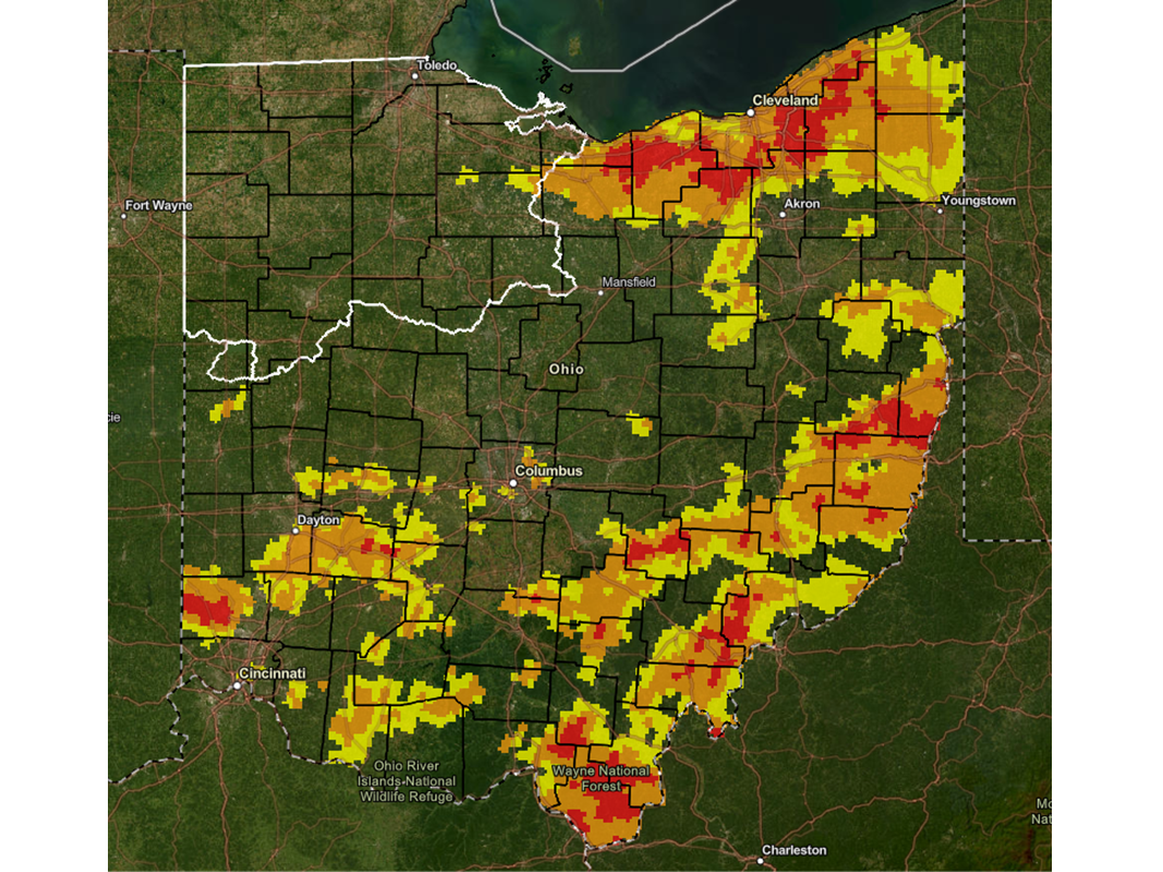
Ohio Runoff Risk Applicator Forecast
Ohio’s essential tool for manure application and water quality protection
The Ohio Runoff Risk Applicator Forecast is a tool that helps farmers, commercial applicators, and land managers determine the best times to apply manure and fertilizers, minimizing nutrient runoff and protecting water quality. Generated by the National Weather Service, it uses real-time data on precipitation, temperature, soil moisture, and snowmelt, along with local soil characteristics, to assess runoff risk statewide. The interactive map divides Ohio into thousands of 4-square-kilometer grids, offering a color-coded, seven-day risk outlook for each area. Updated twice daily, it provides timely guidance for nutrient management. This tool is advisory, and users should supplement it with local knowledge and best practices.
- Interactive maps showing none, low, moderate, and severe runoff risk across Ohio, updated twice daily
- Forecasts incorporate precipitation, temperature, snowmelt, soil moisture, and soil temperature for each grid
- Educational resources and recommendations for responsible manure and fertilizer application

Wisconsin Environmental Mesonet
Statewide coverage for weather and soil monitoring
The Wisconsin Environmental Mesonet (Wisconet) is a growing network of weather and soil monitoring stations across Wisconsin, designed to provide high quality data at high spatial and temporal resolutions. Wisconet plans to deploy at least one station in all 72 Wisconsin counties. Each Wisconet station offers more than a dozen measurements every 5 minutes.
- Statewide data dashboard
- Recent weather maps
- Location-specific agricultural dashboard featuring ag tools

Wisconsin State Climatology Office
Wisconsin’s leader in climate science and services
The Wisconsin State Climatology Office (SCO) promotes regional climate science to benefit various communities, businesses, and agencies in Wisconsin and the Midwest. As a component of UW–Madison’s Rural Partnerships Institute, which aids Wisconsin’s rural and Tribal communities, the SCO operates within the Nelson Institute Center for Climatic Research, the Division of Extension, and the Department of Atmospheric and Oceanic Sciences at UW–Madison. The mission of the SCO is to deliver climate services that enable Wisconsinites to effectively utilize weather and climate information.
- Recent Wisconsin climate condition analysis
- Historical climate data
- Agriculture maps and data
Runoff Risk Advisory Forecast
Wisconsin’s essential tool for manure application and water quality protection
The Wisconsin Runoff Risk Advisory Forecast (RRAF) helps farmers, commercial applicators, and land managers determine when to apply manure and nutrients to cropland, reducing runoff risk and protecting water quality. It uses National Weather Service models to assess runoff risk based on precipitation, temperature, soil moisture, snow accumulation, and snowmelt, displaying this on a color-coded interactive map. Forecasts are updated three to four times daily, offering timely nutrient management guidance. While not regulatory, the RRAF supplements local knowledge and nutrient management plans.
- Interactive maps showing low, medium, and high runoff risk across Wisconsin
- Guidance to cut nutrient runoff and safeguard water quality, especially during high-risk periods periods
- Educational resources for best practices in manure application