Ag Climate Dashboard: Forecast
Find a forecast for another location
The weather forecast data used in this dashboard is sourced directly from the National Weather Service (NWS) API, provided by the United States government.

NOAA National Forecast Maps
Access various national forecast maps
The National Forecast Maps page from NOAA’s National Weather Service offers a detailed collection of weather forecast maps for the US.
- Short- to medium-range forecast maps that display pressure patterns, weather fronts, and precipitation for upcoming days
- Quantitative Precipitation Forecast maps with expected precipitation amounts
- Forecast maximum and minimum temperature, wind speed, direction, gusts, and sky cover maps

WPC Quantitative Precipitation Forecasts
View forecast precipitation over the next 7 days
The Weather Prediction Center (WPC) Quantitative Precipitation Forecast (QPF) page provides national forecasts of total liquid precipitation expected over the US for periods ranging from 1 to 7 days.
- Maps showing expected daily precipitation totals and cumulative totals for multi-day periods (e.g., Days 1-2, Days 1-3, Days 1-5, and Days 1-7)
- Access archived QPF maps to review past precipitation forecasts

WPC Day 3-7 Hazards Outlook
View near-term weather hazards
The WPC Day 3-7 U.S. Hazards Outlook page provides a comprehensive outlook of significant weather-related hazards expected across the United States during the medium-range period, specifically Days 3 through 7 ahead.
- Color-coded maps highlighting areas at risk for various hazards, including excessive rainfall, flooding, extreme heat or cold, high winds, wildfire threats, and drought conditions

NOAA/NWS Storm Prediction Center
View severe weather outlooks and risks
The Storm Prediction Center (SPC) provides daily outlook maps and detailed forecasts for severe weather hazards, including tornadoes, large hail, and damaging winds across the United States.
- Categorical and probabilistic maps showing severe thunderstorm and tornado risk areas
- Forecasts for wildfire risk
- Real-time updates on severe weather threats, including mesoscale discussions and watches
Climate Prediction Center (CPC) Outlook Maps
The CPC issues official U.S. government outlooks for temperature, precipitation, and drought from 6 days to 13 months in advance. Click any map for the latest details and interactive versions.
| Period | Temperature Outlook | Precipitation Outlook |
|---|---|---|
| 6-10 Day Details |

|

|
| 8-14 Day Details |

|

|
| Week 3-4 Details |

|

|
| Monthly Details |

|

|
| Seasonal (3-Month) Details |

|

|
Day 8-14 US Hazards Outlook
| Composite Map |
|---|

|
| Temperature Hazards | Precipitation Hazards |
|---|---|

|

|
| Snow Hazards | Wind Hazards |
|---|---|

|

|
U.S. Drought Outlook
| Monthly | Seasonal |
|---|---|

|

|

Climate Prediction Center ENSO Monitoring
View current and historical ENSO status and forecasts
The CPC ENSO page provides comprehensive monitoring and analysis of the El Niño–Southern Oscillation, including atmospheric and oceanic indicators, time series, and subsurface data.
- Weekly and regional sea surface temperature (SST) anomalies
- Subsurface tropical Pacific temperature and depth analyses
- Time series for Niño regions and standard ENSO indices
- Links to ENSO discussions, research, and FAQs
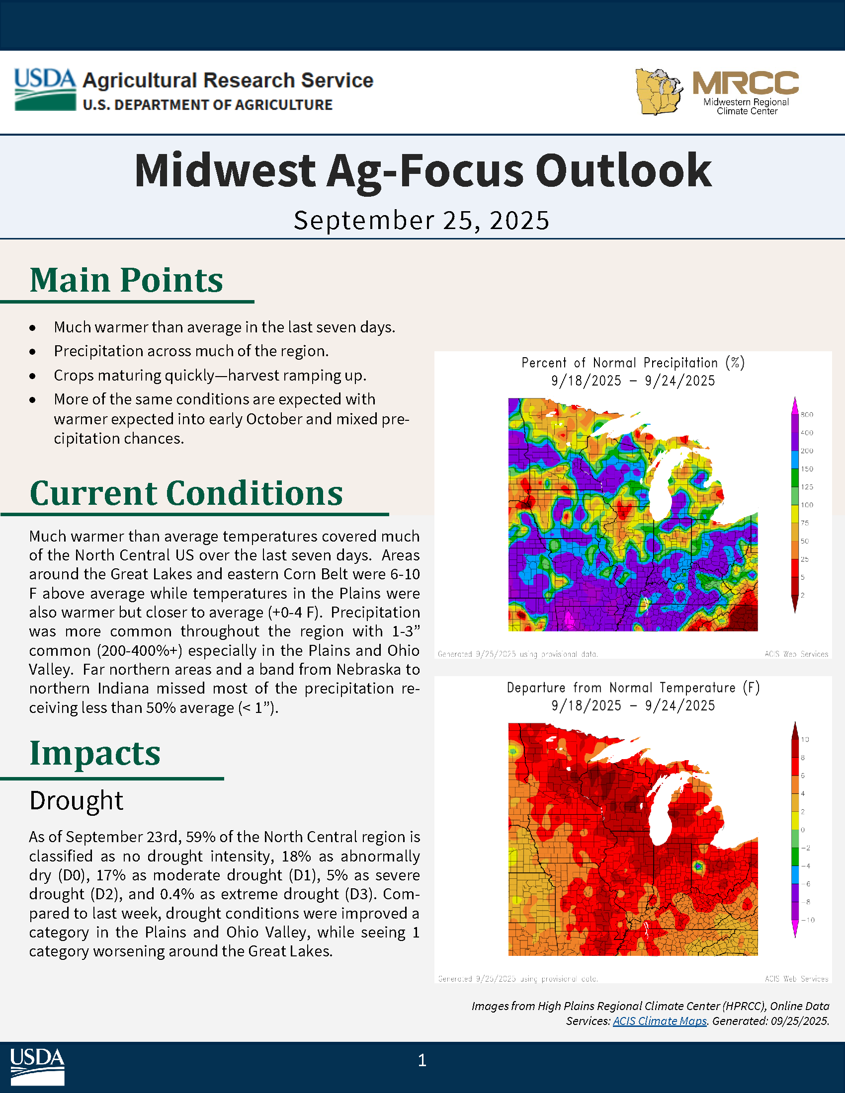
Midwest Ag-Focus Outlook

Access Midwest Ag-Focus Climate Outlooks by year, sorted newest to oldest.
Current Issue Preview