February 2015
Midwest Highlights - February 2015
Colder February
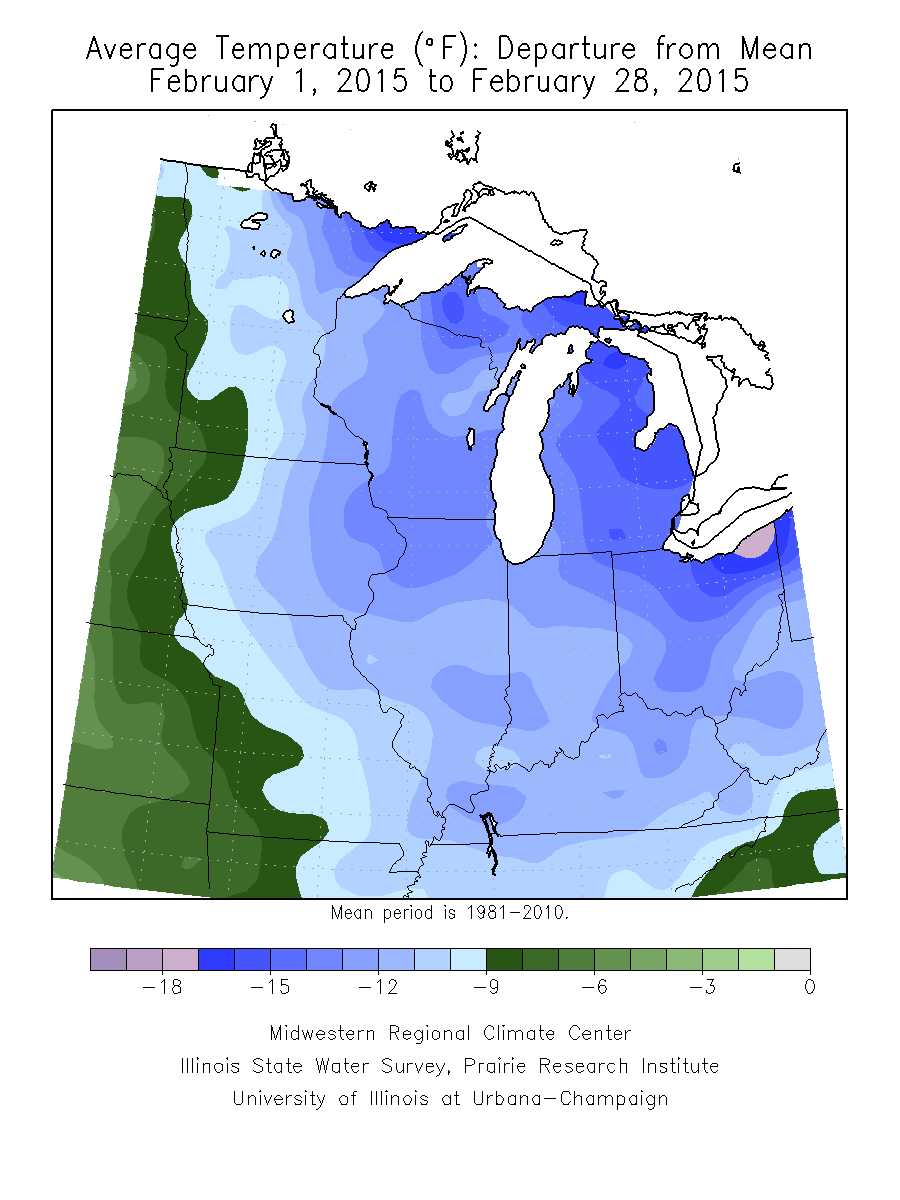
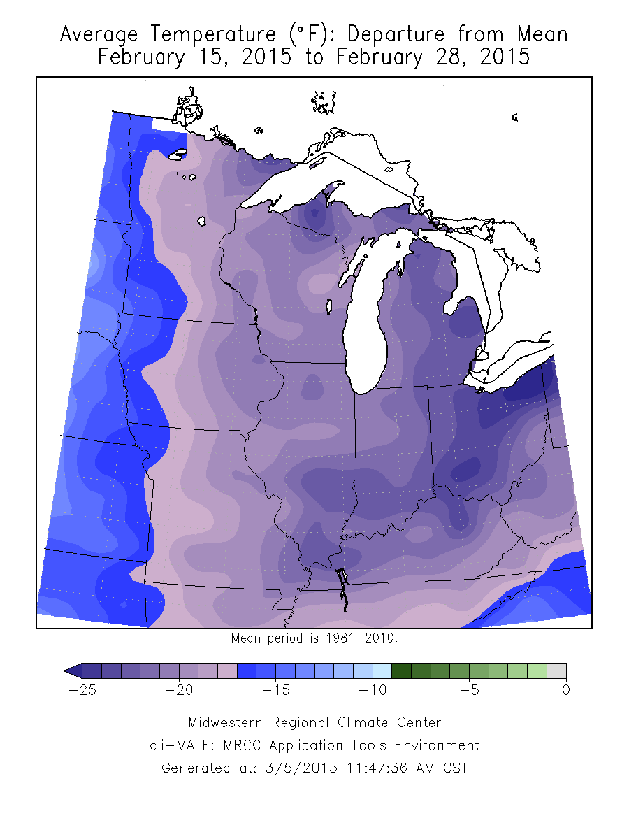
February 2015 had some of the coldest temperatures seen in decades, tying the year 1904 as the 7th coldest February on record (1895-2015) for the Midwestern Region. The region’s average temperatures for February ranged from 9.0 to 17.0°F below zero across the region (Figure 1), averaging 15.4°F for the region as a whole. The coldest temperatures in February impacted the region during the last half of the month. During this time average temperatures were 17.0 to 25.0°F below normal. The coldest temperatures impacted eastern Michigan and Ohio (Figure 2). Many record low temperatures impacted the region February 15 - 19, 2015, with additional temperature records set in eastern Michigan and northeast Ohio on February 23 and 24, 2015. All states had average temperatures that placed them in the top 20 coldest Februarys on record - with four states experiencing temperatures that placed them in the five coldest Februarys on record: Ohio had its 2nd coldest February on record with an average temperature of 17.5°F, Michigan had its 3rd coldest February on record with an average temperature of 8.3°F, and Kentucky and Indiana had their 5th coldest February on record with average temperatures of 26.7°F and 19.3°F, respectively.
Winter Season Temperatures
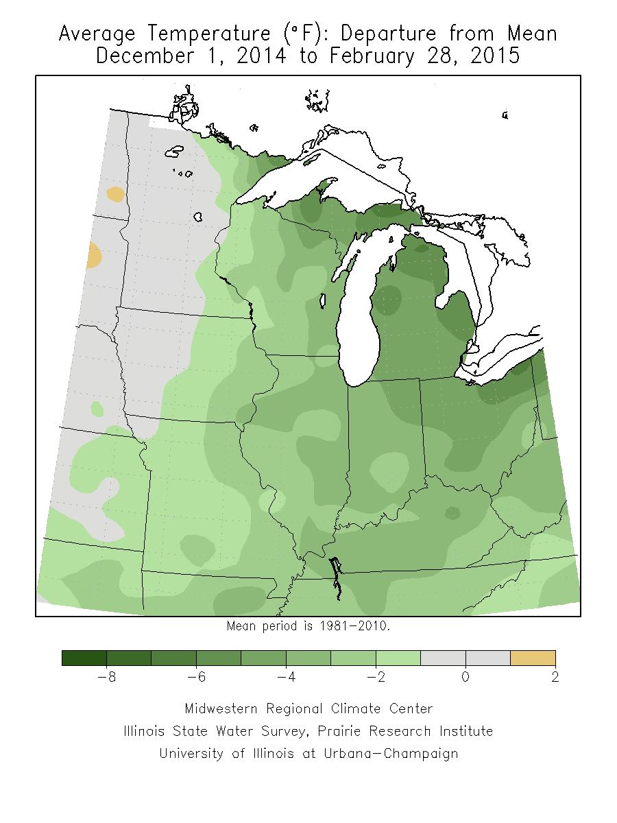
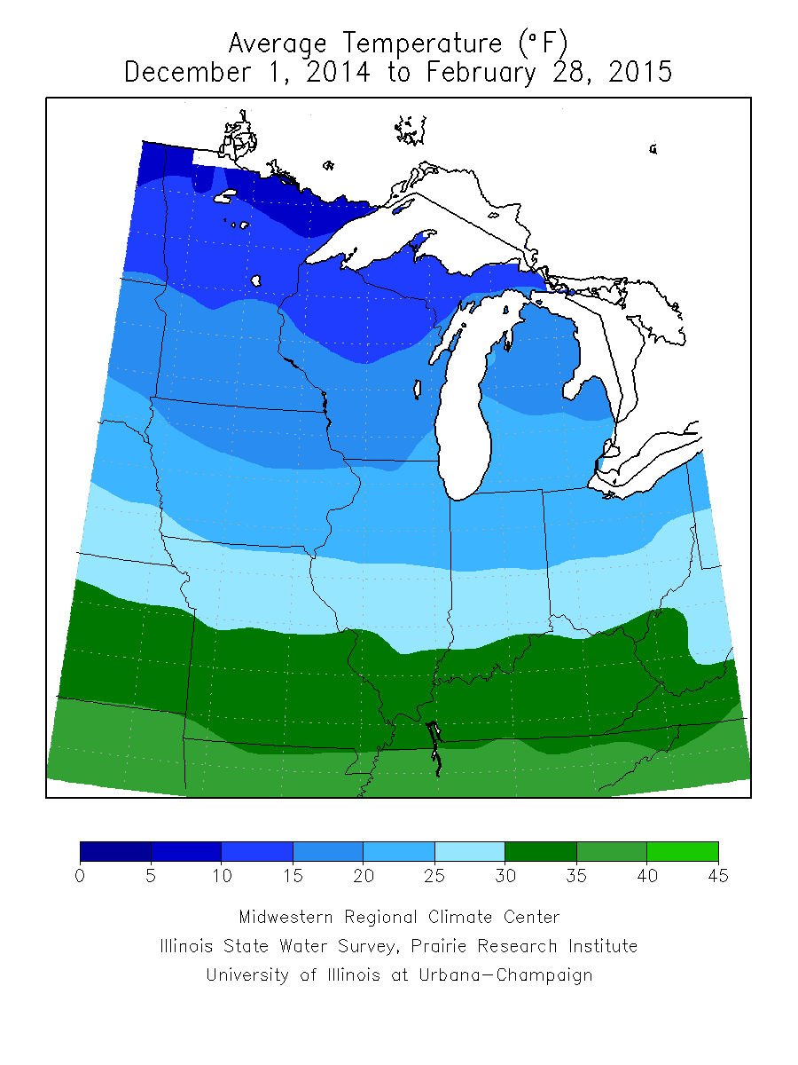
The winter season across the region provided average temperatures 1 to 4°F colder than normal except in Minnesota and western Iowa where average temperatures were near normal. Even colder average temperatures (5 to 6°F below normal) were found in Michigan, northeast Indiana, north and central Ohio, and the Upper Peninsula region (Figure 3). This resulted in average temperatures for the winter season below 30°F as far south as the southern half of Missouri, the southern portions of Illinois and Indiana. Kentucky only averaged temperatures between 30 and 35°F (Figure 4). While December was a warmer than normal month for the region by several degrees F, a pattern shift in January led to colder than normal average temperatures for the month of January across much of the eastern half of the region. By February, average temperature departures of 9 to 15°F below normal presided over much of the region (Figure 1). The arctic air that moved into the eastern half of the region during January and settled in place across much of the region through February made the warm start of the winter season finish as one that was colder than average. Regionally, the 2014-2015 winter season experienced its 45th coldest winter on record with an average temperature of 22.6°F tying with winters 1967-1968 and 1963-1964. Michigan and Ohio were the coldest states in the region this past winter. Michigan experienced its 19th coldest winter with an average temperature of 17.7°F and Ohio experienced its 20th coldest winter on record with an average temperature of 25.7°F.
Snow-filled February
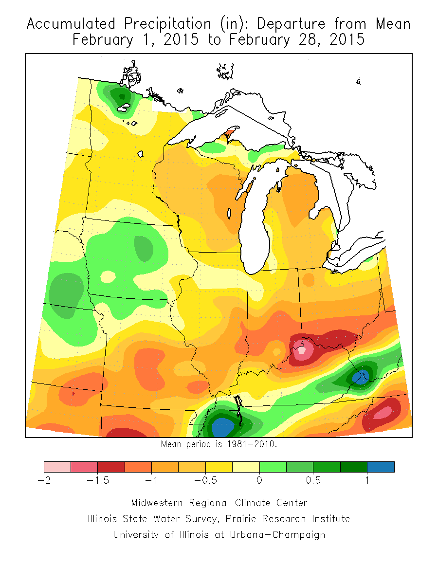
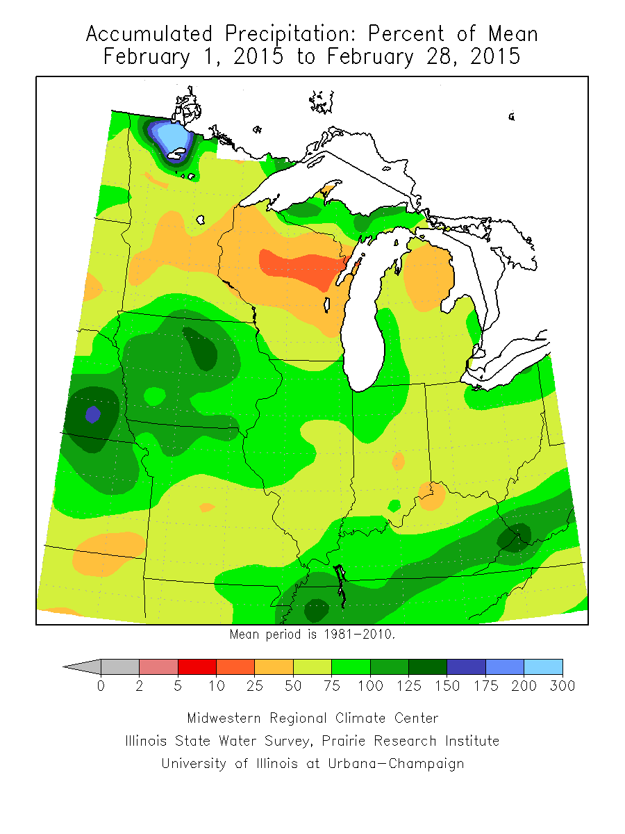
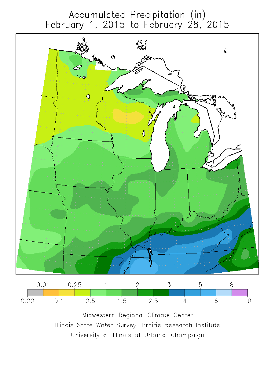
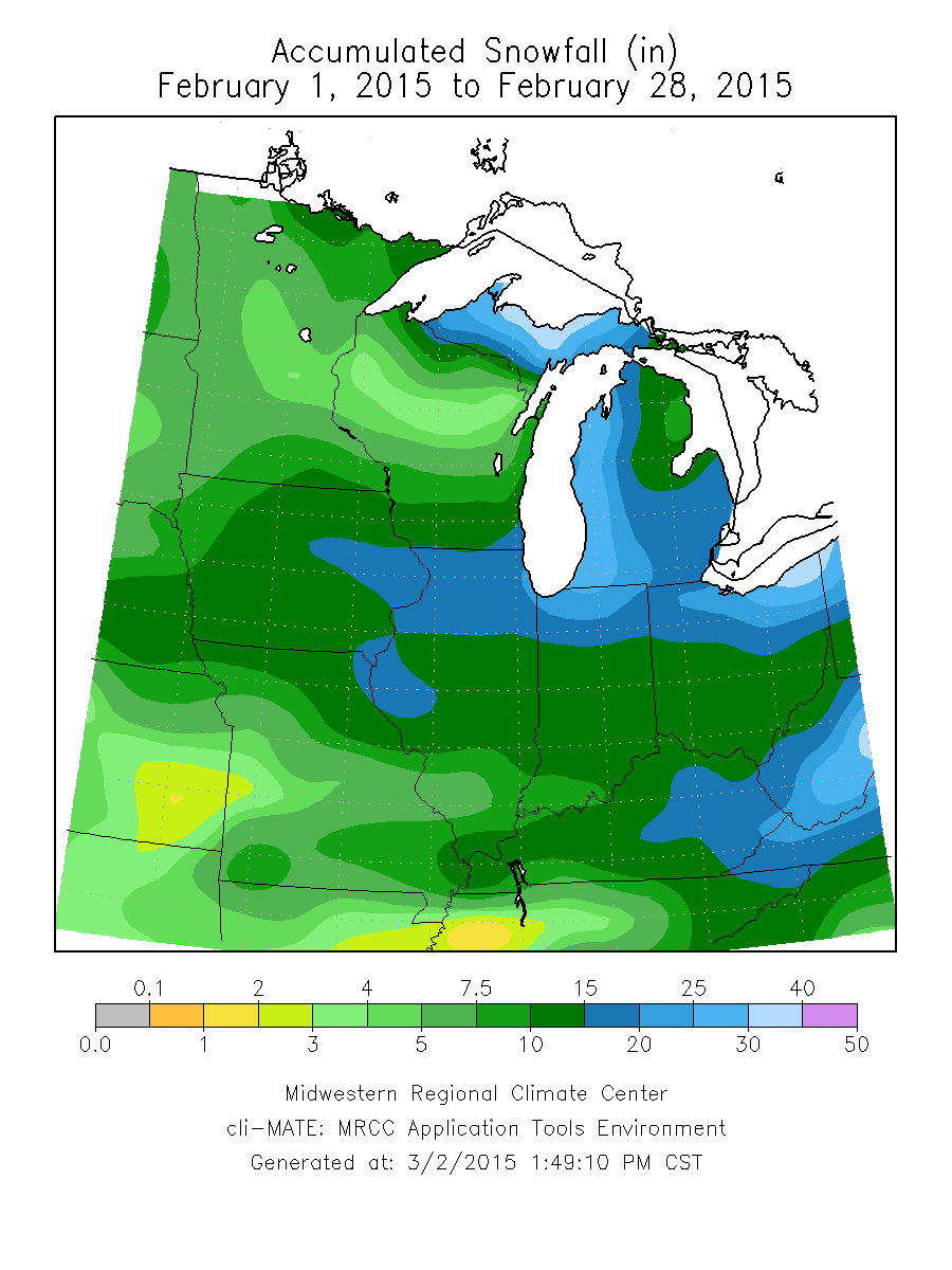
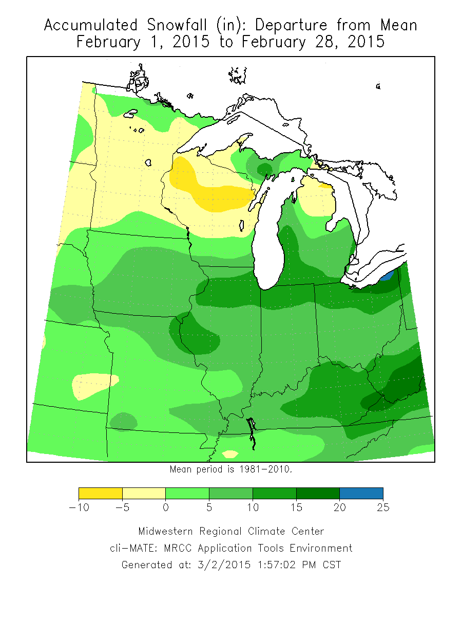
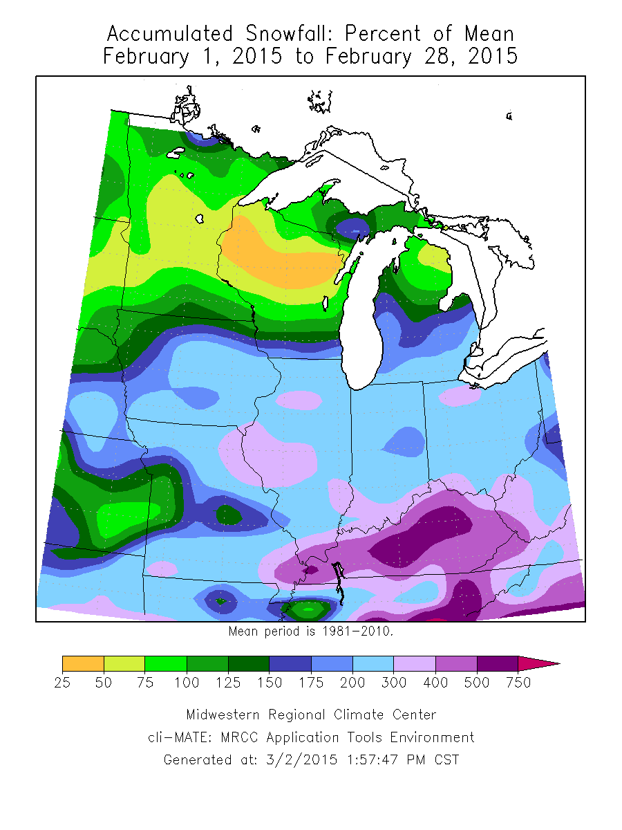
February accumulated precipitation across the region remained 0.5 to 1.25 inches below normal except in southeast Kentucky, northern Missouri, most of Iowa, and small areas along Lake Superior and Lake of the Woods which were only 0.25 to 0.5 inches above average (Figure 5). This resulted in a majority of the Midwest region experiencing only 50-75 percent of normal accumulated precipitation with the entire region experiencing its 28th driest February on record only observing 1.21 inches, 0.51 inches below normal (70 percent of normal) (Figure 6). Accumulated precipitation totals for February were 0.25-0.5 inches across much of Minnesota and Wisconsin, increasing to 0.5-1.5 inches heading south towards the Ohio River valley with isolated regions recording 2.0 inches. Kentucky saw a majority of the precipitation across the region with 3.0 or more inches recorded across the state except in the far north near Cincinnati, and Kentucky recorded a monthly total of 3.23 inches (Figure 7). Wisconsin was the driest state in February, placing February 2015 as its 13th driest February on record observing only 0.4 inches of precipitation. While all other states experienced below normal accumulated precipitation, placement of driest February on record ranged from 23rd driest on record (Michigan) to 62nd driest on record (Iowa). February snowfall across the region was abundant except in Minnesota and Wisconsin where snowfall and precipitation totals remained below normal (Figure 8). January 31 – February 2, 2015 a near-record snowfall event made its way across the central Midwest (Iowa, northern Illinois, Indiana, Ohio, and southern Michigan), dropping a storm total of 19.3 inches of snow at O’Hare International Airport. A second winter storm impacted the southern half of the Midwest February 15-17, 2015. Kentucky received 12-18 inches of snowfall from this storm, resulting in a state of emergency declaration for the state. Additional winter systems moved across the region February 20-22, 2015 and February 28 - March 1, 2015. Parts of northern and far southeast Missouri measured over a foot of snowfall due to these systems, 8-10 inches above normal for the month (Figure 9). Accumulated snowfall by the end of February was greatest near the lake shores due to lake effect snow events, followed by northern Illinois, Indiana, Ohio, and southern Michigan. Eastern Kentucky also experienced accumulated snowfall above 15 inches. The remaining portions of the Midwest had 10 or more inches of accumulated snowfall with southwest Missouri, much of Minnesota, and the northern two-thirds of Wisconsin having less than 10 inches of accumulated snowfall. By the end of the month, accumulated snowfall as a percent of normal was at 400 percent across Kentucky, and 200-300 percent across the region except in Minnesota and Wisconsin (25-100 percent of normal) (Figure 10).
Winter Season Precipitation
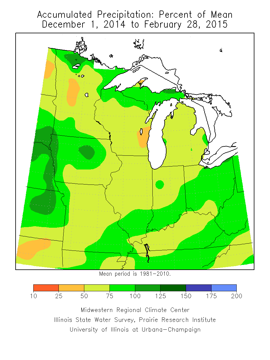
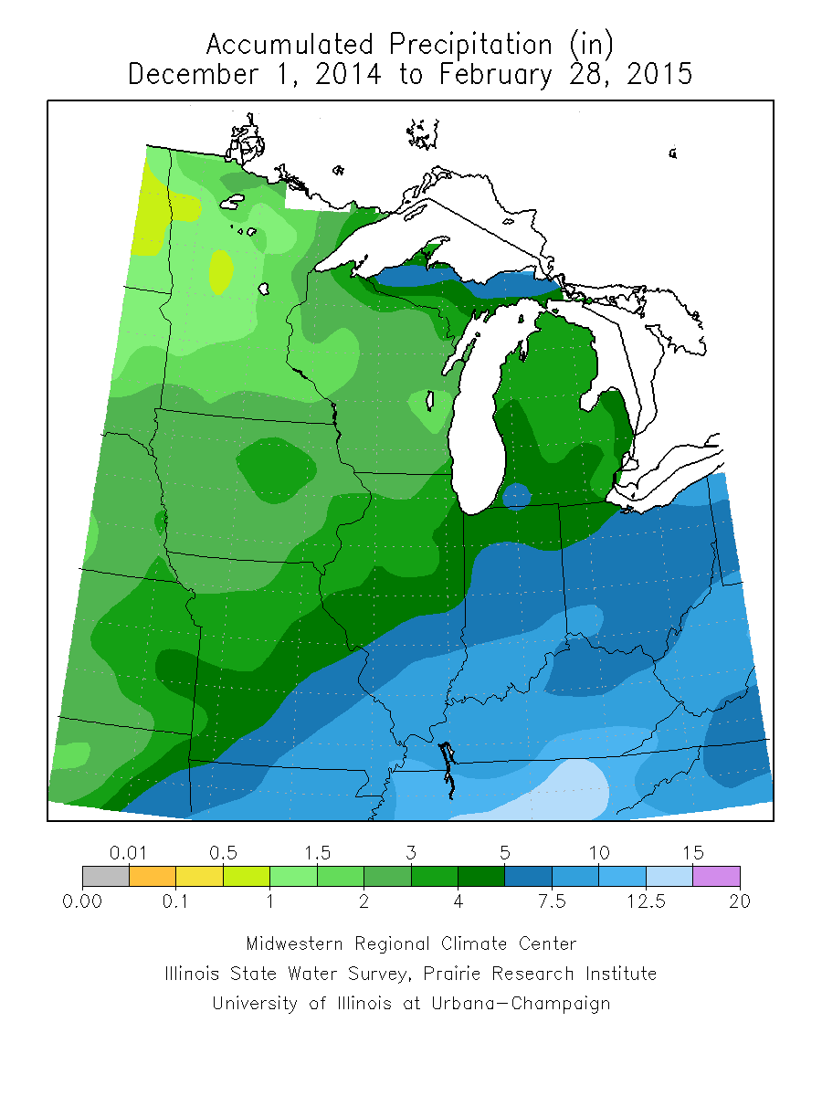
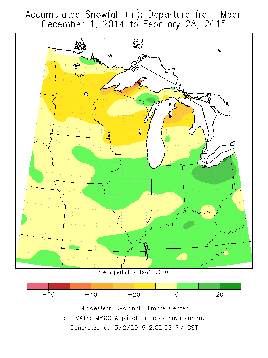
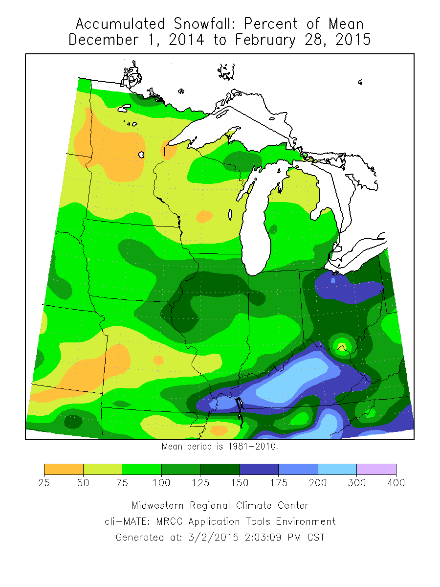
The region was drier than normal during the 2014-2015 winter season in terms of total accumulated precipitation, with portions of Kentucky and southwest Missouri being 3 to 5 inches below normal. Ohio, Indiana, Illinois, remainder of Missouri, Michigan, eastern Iowa and Minnesota, along with much of Wisconsin were all 1.0 to 3.0 inches below normal (Figure 11). The Midwest region observed precipitation during winter 2014-2015 was 4.2 inches, 1.5 inches below normal and the 15th driest winter on record for the Midwest. No area was 100 percent of normal for the season except a small bull’s eye in north-central Iowa and due south of Lake of the Woods in Minnesota (Figure 12). Accumulated precipitation was heaviest during the winter season across the southeast half of the Midwest, with 4 inches to greater than 10 inches observed across the southern half of Illinois, Indiana, Ohio, Kentucky, and southeast Missouri. To the northwest, observed precipitation for the winter season gradually decreased to 1 inch or less in northwest Minnesota (Figure 13). Minnesota observed a total of 1.65 inches during the winter, tying for its 20th driest winter on record. Wisconsin and Michigan experienced their 16th and 17th driest winter seasons on record, respectively. Wisconsin recorded 2.29 inches and Michigan recorded 4.01 inches. Accumulated snowfall for the winter season was below normal for about half of states in the Midwest. The northern halves of Illinois and Indiana, Ohio, Kentucky, northeast Missouri, east-central Iowa, and areas of far southern Illinois and southeast Missouri along and near the Ohio River, experienced accumulated snowfall amounts up to 10 inches above normal while all other areas were below normal by up to 20 inches (lake effect regions in northern Michigan, the Upper Peninsula, and far northern Wisconsin were up to 40 inches below normal) (Figure 14). Until February when most of this winter’s snowfall fell, those regions with above normal accumulated snowfall were actually below normal for the season. Kentucky ended the season observing 125 percent of normal accumulated snowfall, while Ohio, the northern halves of Illinois and Indiana, and southeast Michigan were 100 percent of normal. Elsewhere, states were 75-100 percent of normal for accumulated snowfall. Central Missouri, Minnesota, and much of Wisconsin saw only 25-75 percent of normal accumulated snowfall (Figure 15).
Drought Monitor and Climate Events
February Drought Monitor
Despite the greater than normal precipitation with the February snowstorm across Kentucky, long term, D0 drought conditions remained in place across much of Kentucky, primarily west of the Appalachian Mountains. Minnesota remained in D0 drought for the entire month, as little precipitation fell across the state.
Seasonal Drought Monitor
At the beginning of winter, much of Minnesota and far northwest Iowa were classified as Abnormally Dry on the U.S. Drought Monitor and remained classified as such through the season. Entering mid-December, western Kentucky and far southeast Missouri joined the ranks of Abnormally Dry. Conditions remained stationary till mid-January when growth of the water shortage in Kentucky spread eastward and reached Moderate Drought status in the far southwest. By January 27, 2015 the lack of precipitation across the region resulted in additional growth of drought conditions: all of Minnesota had been classified as Abnormally Dry with small isolated regions of Moderate Drought, followed by a dry region across southeast Iowa, northern Missouri, northwest Illinois, and southern Wisconsin. Abnormally Dry and Moderate Drought in Kentucky was noted across the state west of the Appalachian Mountains. Following the January 31 – February 2, 2015 winter storm across the central Midwest, drought status was removed across Missouri, Iowa, and northwest Illinois. Southern Wisconsin remained in drought status having received little snow from the event. Much of Kentucky reached Moderate Drought conditions by February 17th but received relief from additional winter storms so that by March, drought status for the state had been downgraded to Abnormally Dry along the northern counties near the Ohio River west of the Indiana and Ohio state line.
On January 31-February 2, a winter storm brought heavy snow to the Midwest. Amounts of 6–12 inches were common throughout Iowa, northern Missouri and northern Illinois. Areas west of Lake Michigan were hardest hit due to lake-enhanced snowfall rates. Snowfall totals from extreme southeastern Wisconsin into northeast Illinois and northwest Indiana were in the 12–20 inch range. A blizzard warning was put into effect for the Chicago area on the 1st and a storm total snowfall of 19.3 inches was recorded at O’Hare with 19.2 inches recorded at Midway in Chicago. The snowfall total at O’Hare was ranked as the fifth highest storm total snowfall total for Chicago. The 16.2 inches that fell on February 1 was the highest total for any February day in Chicago and was the second highest single day snowfall for the city to date. Additionally, this storm system brought a large amount of precipitation to the region. Areas in Iowa and Missouri through southern Michigan received more than an inch of liquid precipitation. The storm resulted in nearly 1,300 flight cancellations and many delays in the Chicago and Midwest areas.
Intrusion of cold, arctic air the second half of February due to the mean storm track being farther south than normal resulted in winter weather as far south as Kentucky and Tennessee. This sadly resulted in the deaths of 30 individuals due to car accidents, hypothermia, and carbon monoxide. The Midwest was impacted greatest by bitter cold temperatures February 16-19, 2015, with much of the region experiencing minimum temperatures below zero on the 19th. Nearly all of Wisconsin and Minnesota were 10°F below zero with northern Wisconsin, Minnesota and the western U.P. of Michigan 25-35°F below zero. The western Ohio Valley also saw temperatures 5-15°F below zero with wind chill advisories and warnings for wind chills of 15-30 °F below zero.
Another major snowstorm impacted the Midwest late on February 28, 2015 into March 1, 2015. Over 4 inches of snow fell from Missouri through Ohio. The heaviest snow fell in east-central Illinois through central Indiana where snow totals of 6 to 9 inches were common. This was the fourth major snowstorm to impact the Midwest in 30 days.
With temperatures for the month of February 10-15°F below normal along the Great Lakes, ice cover increased quickly in the month of February. Lakes Erie and Huron became almost completely ice covered. On February 18th, the Great Lakes Environmental Research Laboratory estimated ice cover on the Great Lakes to be 85.4 percent. As of March 3, 2015, ice cover estimates had reduced to 77.8 percent.
Seasonal climate events in addition to these listed for February included reports of wind damage and a brief EF0 tornado in central Ohio December 24, 2014 due to a weak linear convective system ahead of a cold front On January 9, 2015, southern Michigan experienced a 190-vehicle pileup during winter weather hazards in Kalamazoo and Calhoun Counties. There was one fatality, numerous injuries, fires and spilled cargo, evacuations of homes, and closure of Interstate 94 in both directions for much of the day.