June 1-9, 2008
Midwest Weekly Highlights - June 1-9, 2008
Heavy Rain, but Warmer
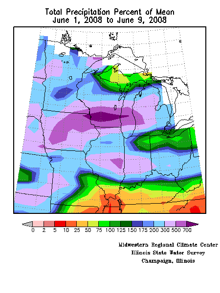
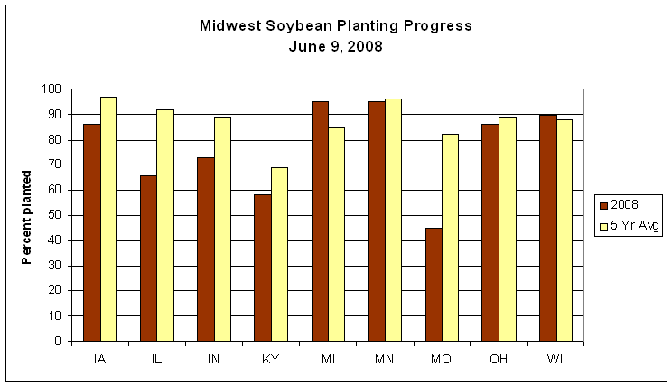
The wet weather pattern that persisted throughout much of May continued through the first week of June with devastating results. Midwest rainfall was much above normal with a few minor exceptions. Precipitation the first nine days of June was 200 to 700 percent of normal through much of the region (Figure 1). The exceptions were from southeastern Missouri eastward across far southern Illinois and the southern two-thirds of Kentucky, in the Michigan Upper Peninsula, and from northeastern Indiana across northern Ohio. The heavy rain is having a large impact on agriculture on two fronts. Spring planting of soybeans, already delayed because of a cool and wet April/May, continues to run behind schedule, with Missouri and Illinois furthest behind (Figure 2). Although corn planting was mostly complete by the end of May, many fields in Illinois, Iowa, and Indiana were inundated with rain this period. Many of these these fields will have to be replanted, and yields will be reduced because of the late planting. USDA reported that only one tenth of the planted corn has emerged, well behind the average.
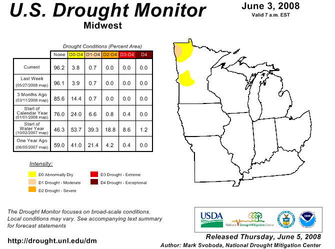
A small area of Moderate Drought continues to be depicted in northwestern Minnesota on the latest U.S. Drought Monitor (Figure 3). However, heavy rain in Minnesota occurring after the USDM was compiled on June 3 has led to some relief from the dry weather.
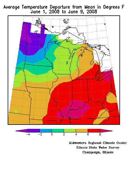
On the positive side, temperatures at the start of June were above normal over the southeastern two-thirds of the region (Figure 4). This favored crop development in areas not affected by the heavy rain. Temperatures over the Ohio Valley were as much as 8°F above normal, with much of the southeastern half of the region 6°F above normal or more. The only area of below normal temperatures was northwestern Minnesota.
Severe Weather Pounds Midwest
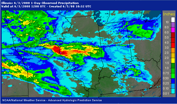
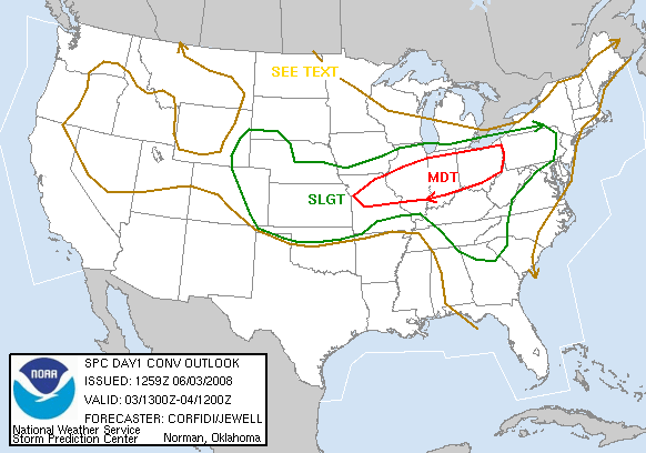
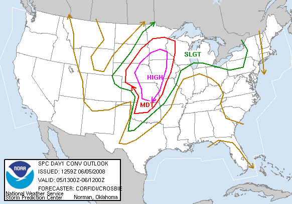
The first two days of June were relatively quiet after a stormy end to May, but the calm did not last long. A few severe storms developed in the the western portions of the region on June 2, marking the start of a week-long period when every state in the nine-state region experienced severe storms and tornadoes. The severe weather went into high gear on June 3 as the cold front pushed into the central Midwest and a wave of low pressure developed on the front in Kansas (Figure 5). A complex of thunderstorms during the early morning hours of June 3 produced some severe weather. It also dropped two to four inches of rain from southeastern Iowa and northeastern Missouri across central Illinois (Figure 6). A large area along and south of the front from Missouri eastward through Ohio was in a moderate risk for severe weather on June 3 as storms were again expected to erupt during the afternoon and evening (Figure 7). Severe storms occurred throughout the risk area, with tornadoes reported in Missouri, Illinois, Indiana, and Ohio. Five tornadoes touched down in Indiana, one rated an EF3 and another an EF2. The EF3 tornado occurred in Shelby and Rush counties southeast of Indianapolis. The tornado struck the town of Moscow, heavily damaging several homes and injuring several people. One woman was in serious condition after being impaled in the upper chest by a 3-inch diameter tree limb. The tornado also destroyed a 19th century covered bridge. The EF2 tornado set down in Brown County, IN and traveled into Johnson County. This tornado damaged 40 buildings at the Indiana National Guard's Camp Atterbury 25 miles south of Indianapolis. Two soldiers suffered minor injuries as they ran for shelter. More than 2,000 soldiers were at the camp, including a Marine unit training for deployment to Iraq. The twister skipped over the barracks were they were sleeping. Very heavy rain also occurred with the storms that moved eastward overnight from Iowa into Illinois.
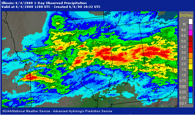
During the afternoon of June 3 and into the early morning hours of June 4, training thunderstorms (storms that develop and repeatedly move over the same areas) resulted in more than three to five inches of rain from portions of central Illinois through central Indiana into west-central Ohio (Figure 8). In Illinois, this was on top of the two to four inches that had fallen early on June 3. As the front remained stationary across the central Midwest, it provided the focus for additional severe thunderstorm development during the afternoon of June 4. Reports of severe weather stretched from southwestern Iowa east-southeast to southern Ohio, with tornadoes reported in Iowa, Illinois, Indiana, and Kentucky. Early on June 4 lightning struck a fuel tank holding about 1.2 million gallons of unleaded gasoline in Kansas City, setting it on fire. Firefighters contained the fire and let it burn itself out.
The focus of severe weather shifted to the western portions of the region on June 5 as a strong low pressure system developed over the Central Plains (Figure 9). Southern Minnesota, the western half of Iowa, and northwestern Missouri were included in a High Risk area for severe weather (Figure 10). Tornadoes touched down from northwestern Missouri to south-central Iowa, and severe weather was reported into western Illinois by the early morning hours of June 6. Heavy rain across Iowa with the storms caused a number of problems in central Iowa due to flooding early on June 6. In Cambridge (Story County), a dozen homes were evacuated at 3:00 a.m. In Des Moines, 3.70 inches of rain flooded streets in downtown and several manhole covers popped off due to the rushing water. Severe storms and heavy rain knocked out power and telephone service to the University of Northern Iowa campus in Cedar Falls (Black Hawk County).
On the morning of Friday, June 6 the strong low pressure system was spinning over extreme west-central Minnesota, producing strong southwesterly winds across the Midwest. The strong winds, gusting to 40 mph or more, caused major problems for air travelers. More than 200 flights were canceled at Chicago's O'Hare International Airport due to the high winds through early afternoon, and thunderstorms later in the day. Many more flights experienced delays of 60 to 90 minutes. Power was knocked out to more than 16,000 Commonwealth Edison customers in the Chicago area due to the winds. High winds associated with a thunderstorm were a factor in the 85th running of the Mills Trophy Race near Toledo on Lake Erie on June 6, damaging some boats and causing one to capsize. Winds were reportedly clocked at 85 mph.
Flooding Problems Worsen, Severe Storms Move North
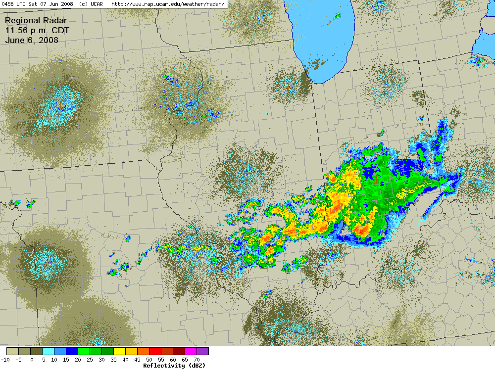
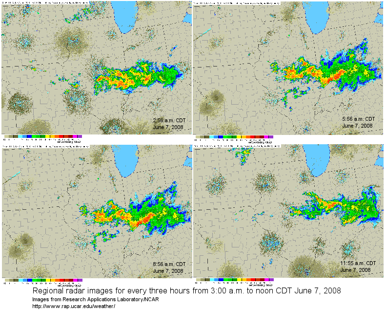
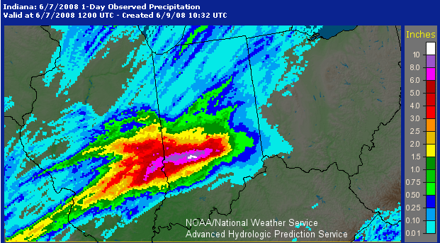
The weak frontal boundary associated with the low in the upper Midwest moved slowly south over the central Midwest. Another thunderstorm complex developed late June 6 and continued into the early afternoon of June 7. Just before midnight CDT on June 6 an area of thunderstorms was occurring from just north of St, Louis, MO to near Terre Haute, IN (Figure 11). This cluster of storms remained over central and east-central Illinois and central Indiana for the next 12 hours (Figure 12), dumping more that nine inches of rain in southeastern Illinois and southwestern Indiana by the morning of June 7 (Figure 13). Flash flood warnings were issued for large portions of east-central and southeastern Illinois and southwestern Indiana as rivers and streams rapidly rose.
The action shifted to the north with the warm front on on June 7. By mid-afternoon severe thunderstorms extended from western Iowa to southeastern Minnesota, and from northwestern Illinois into southern Wisconsin. Numerous tornadoes touched down in Iowa, Wisconsin, and northern Illinois. A tornado in EF2 damage. Several inches of rain soaked northern Iowa, southeastern Minnesota, and southwestern Wisconsin (Figure 14).
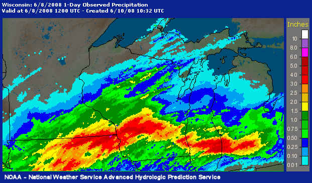
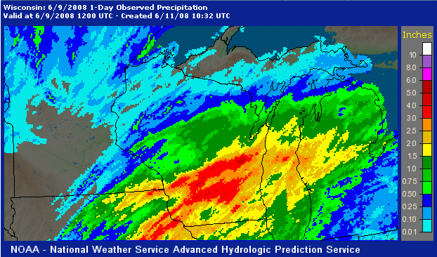
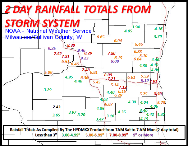
Thunderstorms continued on June 8 from northwestern Missouri through central Iowa, southern Wisconsin, and southern Michigan. There were numerous reports of severe weather, mostly damaging winds. There were four sightings of tornadoes in Iowa and one in western Illinois. Another 3 to 5 inches of rain accumulated from eastern Iowa across south-central Wisconsin (Figure 15). Two-day rainfall totals over southwestern Wisconsin were generally in excess of six inches, with several locations reporting more than nine inches of rain between 7:00 a.m. Saturday, June 7 to 7:00 a.m. Monday, June 9 (Figure 16). Many of the rivers in southwestern Wisconsin and eastern Iowa reached record crests. Scattered severe weather continued on June 9 in western Missouri and the Ohio Valley. The storms produced flash flooding in Missouri, and one tornado in Ohio.
Numerous precipitation records were set the first nine days of June.