August 15-21, 2007
Midwest Weekly Highlights - August 15-21, 2007
Heat Breaks, Skies Open, Drought Intensifies
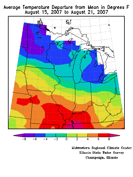
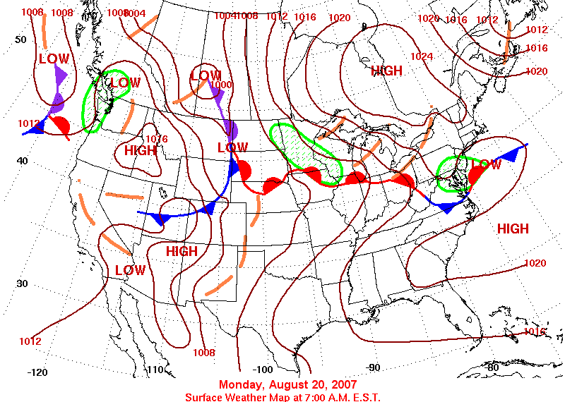
The division between scorching weather in the southern Midwest and much cooler than normal weather in the northern Midwest was very pronounced this week. Temperatures were 6°F to 8°F above normal in south central Missouri into western Kentucky, while from central Wisconsin to northwestern Minnesota temperatures were 4°F to 6°F below normal (Figure 1). High temperature records continued to be set early in the week across the southern Midwest, but in the latter half of the period record low maximum temperatures were being set from Michigan into Minnesota. Cooler and somewhat less humid air did make it as far south as the Ohio Valley. The division between the cooler weather to the north and the hot weather south was marked by a frontal system that oscillated north and south through the region during the week.
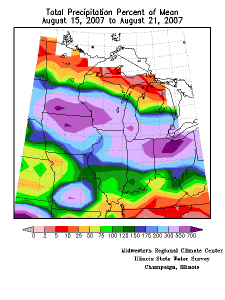
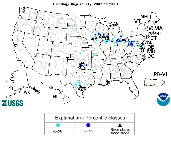
That frontal system was the focus of heavy rain during the week (Figure 2). Rainfall exceeded five to seven times the normal weekly rainfall from northern Iowa through southern Minnesota, western Wisconsin, and across northern Indiana and Ohio producing widespread severe flooding. At the end of the week many rivers and streams across the north central Midwest were experiencing much above normal flows and a number were in flood (Figure 3).
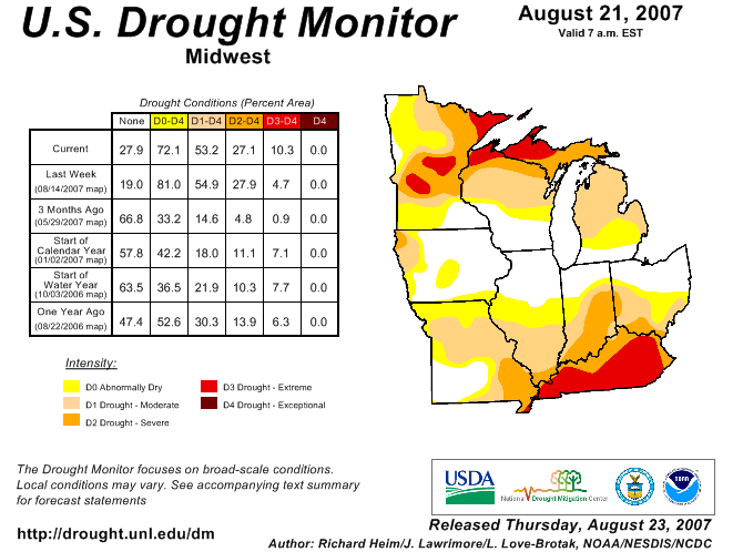
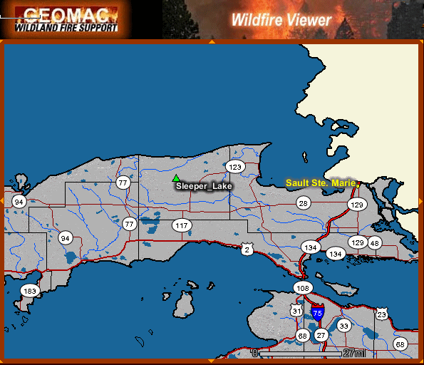
The rain chipped away at the drought in the central Midwest, but generally stayed away from the far northern and southern portions of the region where drought has been most intense and persistent (Figure 4). In those areas, the drought impacts are severe. In the Michigan Upper Peninsula, there was one large active wildfire and numerous smaller fires affecting mostly forested areas in sparsely populated areas. The Sleeper Lake fire, 61 miles west of Sault Ste. Marie, encompassed 18,020 acres and was 67 percent contained as of August 21 (Figure 5). The fire started on August 2 from a suspected lightning strike. On August 16 Michigan Governor Jennifer Granholm issued an outdoor burning ban covering 75 of Michigan's 83 counties because of the persistent dry weather. Burning bans were also in effect for portions of northern Minnesota and northwestern Wisconsin.
Drought impacts continued to mount in Kentucky. A water shortage warning was issued by the Commonwealth for Warren County and the city of Bowling Green. Water shortage advisories were issued for seven counties, and a water shortage watch was issued for most of central Kentucky except along the Ohio River. The dry weather has significantly impacted crops, and it is expected that this year's soybean crop will be the smallest since 1994. The percentage of soybeans in good to excellent condition declined from 46 percent on August 12 to 34 percent on August 19. For more information on the drought conditions in Kentucky, visit the Kentucky Climate Center web site.
In Illinois, the condition of the soybean crop declined slightly in the past week while corn remained steady. The hot and dry weather was speeding development of the crops to the point where producers in some parts of Illinois were harvesting.
Indiana crops continued to deteriorate due to the hot and dry weather. Less than 40 percent of the corn and soybeans are in good to excellent condition, a decline of 3 to 5 percent from the previous week. Crops in northern Indiana are in much better shape than the rest of the state, although some crops were damaged by high winds from severe thunderstorms early this week. Pasture conditions in Indiana were reported as 75 percent poor to very poor at the end of this week.
Finally...A Break from the Heat
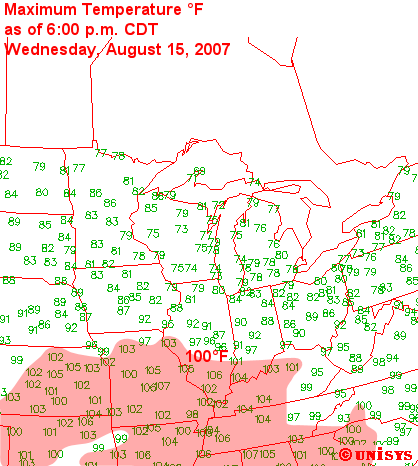
The record hot weather continued over the southern half of the Midwest the first two days of this week. A number of locations in Missouri, Illinois, Indiana, and Kentucky set high temperature records, with Vichy/Rolla, MO soaring to 107°F on August 15 (Figure 6), breaking the old record by a whopping 8°F. In the first 21 days of the month Vichy/Rolla reached or exceeded 100°F nine times, and set new high temperature records on eight of nine days between August 8 and August 16.
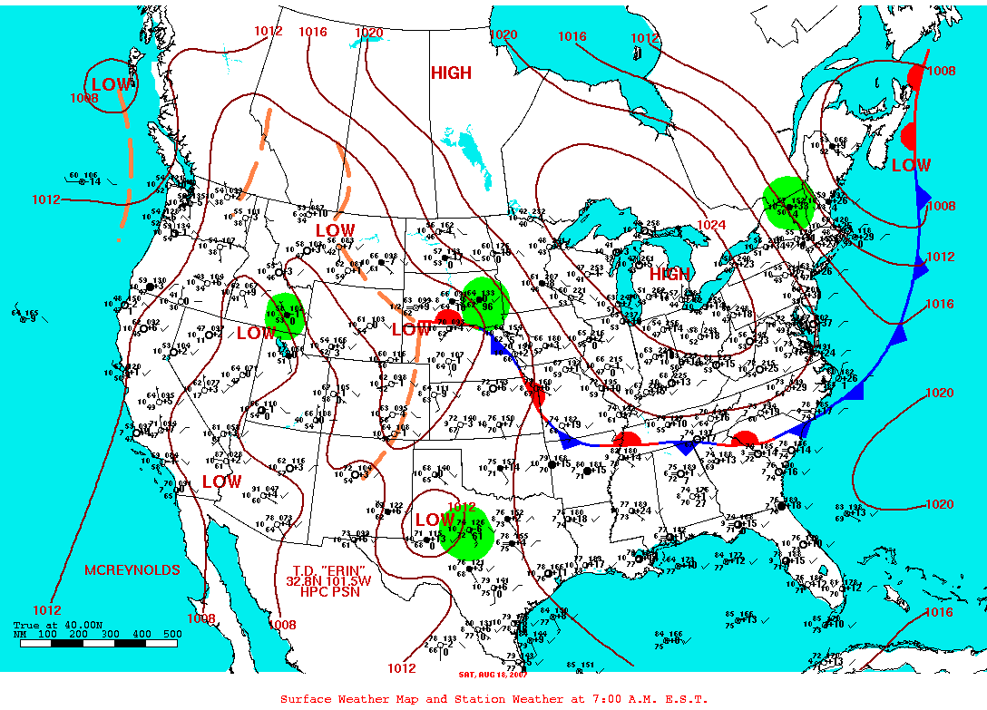
The frontal system draped across the Midwest finally began to move south on August 16, and by the morning of August 18 had pushed as far south as northern Arkansas and southern Tennessee (Figure 7). The cooler and much less humid air covered most of the region. Dewpoints in all but the southwestern half of Missouri were in the 50s, as opposed to the 70s the previous several days. High temperatures in south-central Missouri still reached the mid 90s on August 18, but that was 8°F to 10°F cooler than in previous days.
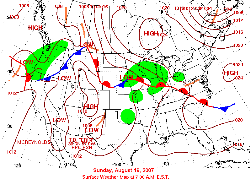
The break was short-lived, however. As the high pressure system at the center of the cooler,drier air mass moved east the warm, humid air began to move northward again on August 19 (Figure 8). However, widespread cloudiness (Figure 9) helped keep temperatures at seasonable levels. The exception was in Kentucky where highs again reached the mid 90s. As of August 20 Louisville, KY had set a new record of 22 consecutive days reaching or exceeding 90°F. The streak ended on August 21 when the high reached only 88°F. The old record was 21 days set in August 1936, July 1901, and August 1900.
The Tropical Midwest
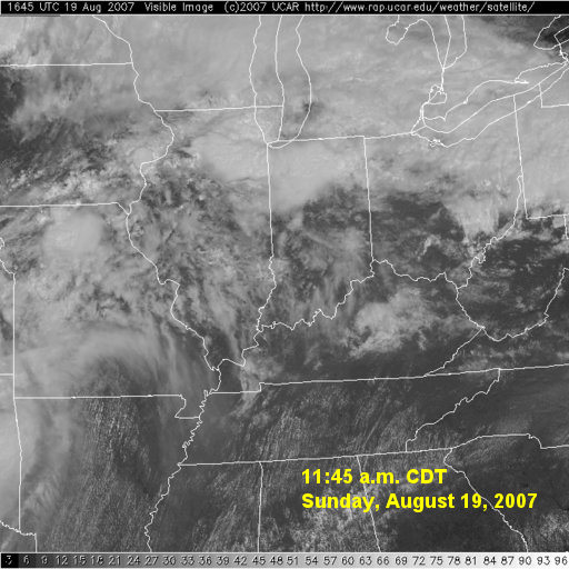
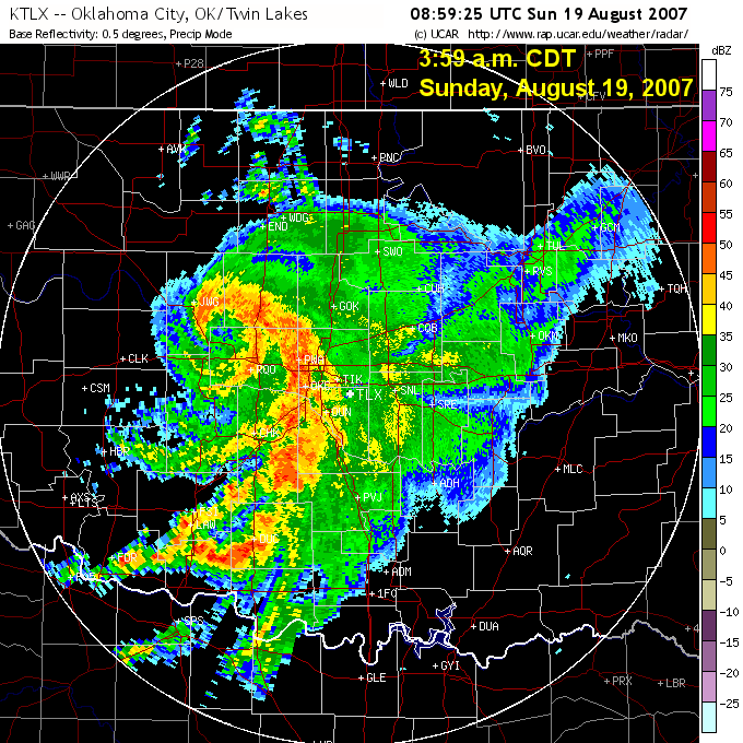
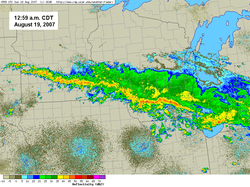
Deep tropical moisture spread northward through the Midwest enhanced by the flow associated with Tropical Depression Erin. On the morning of August 19 Erin was located over central Oklahoma (Figure 10), with a broad area of southwesterly flow across the Midwest. The abundant moisture overrunning the frontal boundary across the Midwest was an ideal setup for torrential thunderstorms (Figure 11, NWS LaCrosse).
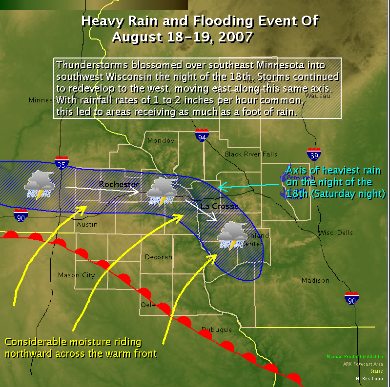
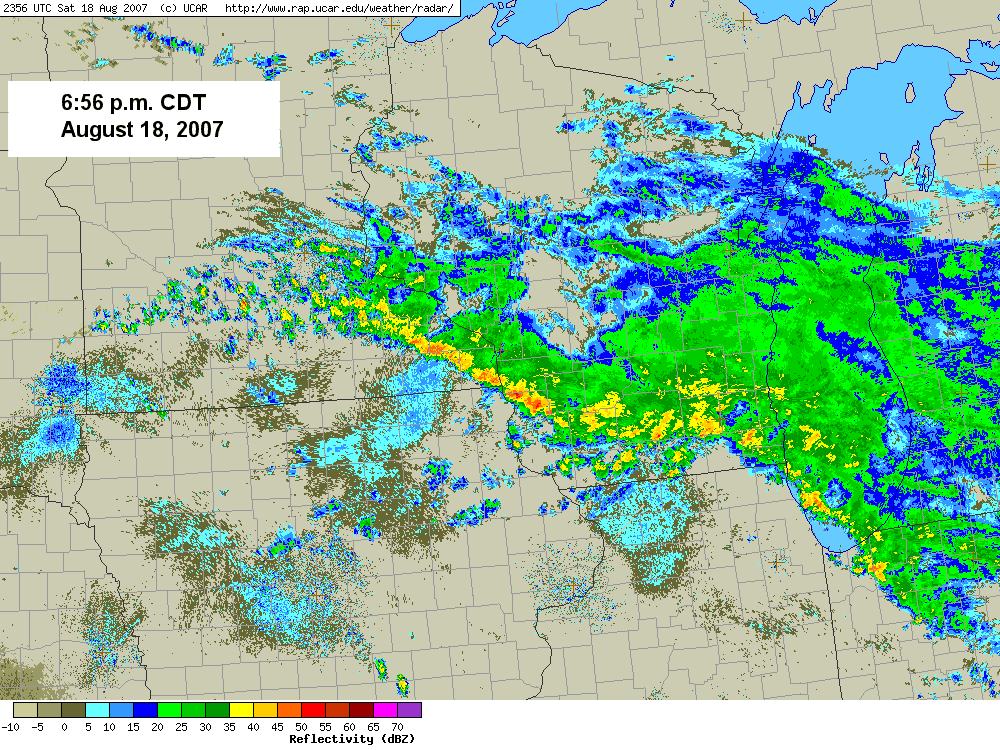
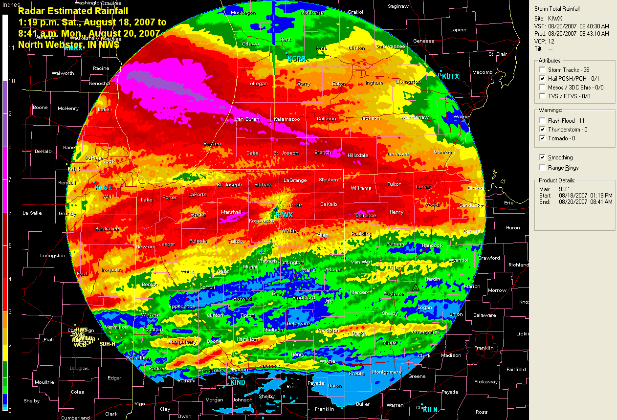
A broad band of thunderstorms set up across southwestern Minnesota and northwestern Iowa during the late evening hours of August 17 and moved slowly northeastward during the next 24 hours before weakening. During the early evening hours of August 18 a narrow band of strong thunderstorms developed across southern Minnesota eastward into western and southwestern Wisconsin (Figure 12). Over the course of the next nine hours heavy thunderstorms continued to develop over and move across the same areas (Figure 13). As much as 10 to 17 inches of rain was reported in southeastern Minnesota, and 10 to 12 inches in adjacent portions of Wisconsin. A report of seventeen inches came from Witoka, MN (Winona County). An observer in Houston County, MN reported a total of 15.60 inches of rain, with 12.73 inches falling in a seven hour period between 8:00 p.m. on August 18 and 3:00 a.m. on August 19. The largest 24-hour total reported by a NWS Cooperative observer was 15.10 inches ending at 8:00 a.m. August 19 near Hokah, MN (Houston County). This established a new all-time 24-hour precipitation record for Minnesota, shattering the old record of 10.84 inches measured at Fort Ripley (Crow Wing County) on July 22 ,1972. More information on this storm can be found at the Minnesota State Climatology Office web site.
The impacts of so much rain in a short period of time over already saturated ground were catastrophic. Numerous roads were closed because they were covered with or washed out by floodwaters. Eight people escaped injury when their houses were pushed over bluffs by mudslides in Brownsville, MN (Houston County). There were seven fatalities in southeastern Minnesota from the flooding. Two fatalities in Minnesota occurred when their vehicle drove into a 30-foot gully where a road used to be. Two other fatalities near Stockton, MN (Winona County) resulted from a vehicle being swept off of the road by floodwaters. Searchers found a man in a tree about four miles from his overturned car near a creek south of Lewiston, MN (Winona County). The 803 residents of Stockton, MN were evacuated, as was the town of Houston, MN. Parts of several other communities were also evacuated. Minnesota Governor Tim Pawlenty declared a state of emergency in Winona, Wabasha, Filmore, Houston, and Steele counties and ordered 240 National Guard troops to the area to help with recovery. A preliminary damage survey by the American Red Cross found about 4,200 homes affected by flooding, including 256 complete losses, 338 with major damage, and 475 that were still inaccessible as of August 21.
Conditions were just as bad in adjacent portions of Wisconsin. A house in Vernon County was swept off a hillside by a mudslide and onto State Highway 35. The Wisconsin Department of Natural Resources was monitoring seven dams in the county for erosion and damage from the flooding. The towns of Gays Mills and Soldiers Grove in Crawford County were evacuated due to flooding. Officals reported that 200 homes were flooded in Gays Mills. A nursing home and residents of 50 to 100 apartments were evacuated in Richland Center (Richland County), and there were at least a dozen boat rescues from homes and cars. Officials of Richland County estimated that $3 million in damages had already occurred as of August 20, and that number was expected to rise. Wisconsin Governor Jim Doyle declared a state of emergency for Crawford, Richland, and Vernon counties. Preliminary damage estimates in Wisconsin exceeded $38 million and were expected to climb even higher as assessments continued. Updated 8/24/07: Wisconsin emergency management officals now estiamte damages at $48 million, with 44 homes destroyed, 290 with major damage, and more than 1,100 with monor damage.
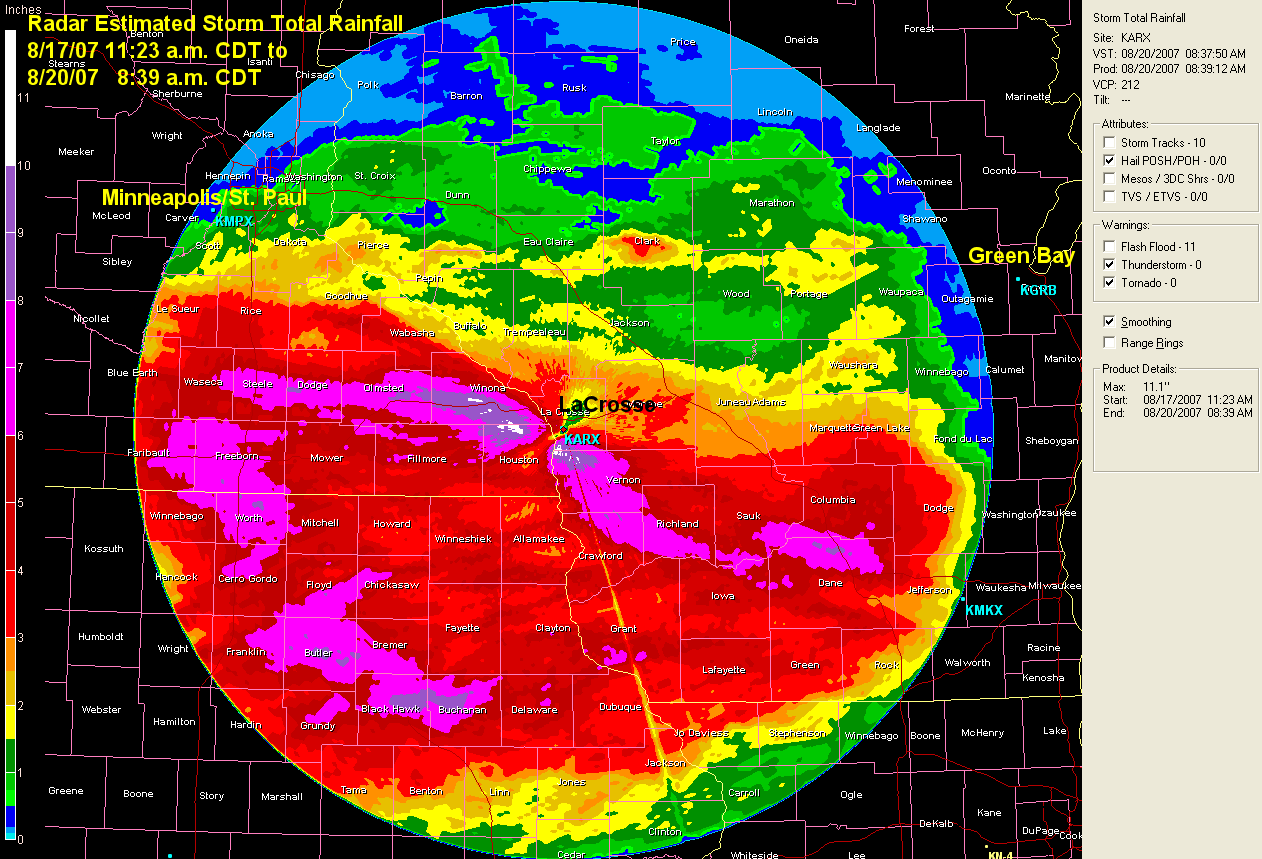
By dawn on August 19 the heavy thunderstorms had finally moved south, although light rain continued over the area through the morning of August 20. Radar estimated rainfall for the event from the LaCrosse National Weather Service radar depicts the pattern of the heaviest rainfall (Figure 14). For more information, including photos of the flooding and damage, visit the La Crosse National Weather Service web site.
Erin Takes Swipe at Missouri
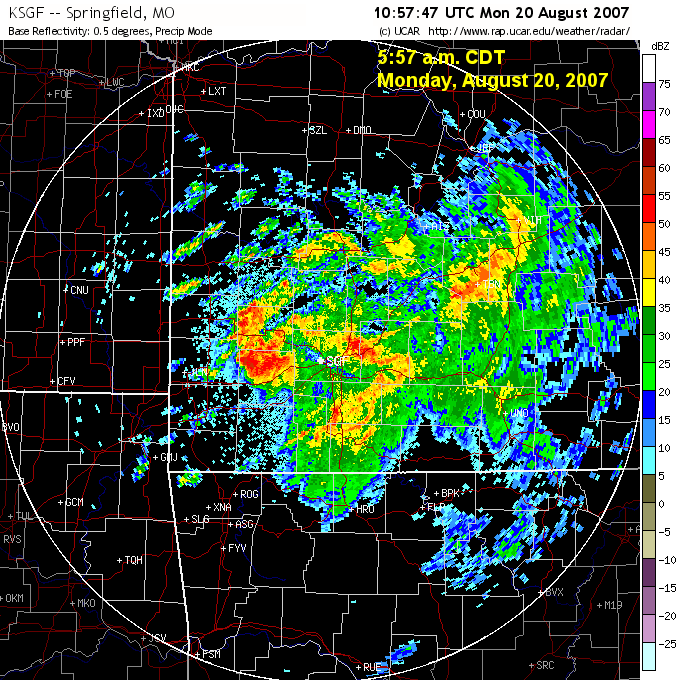
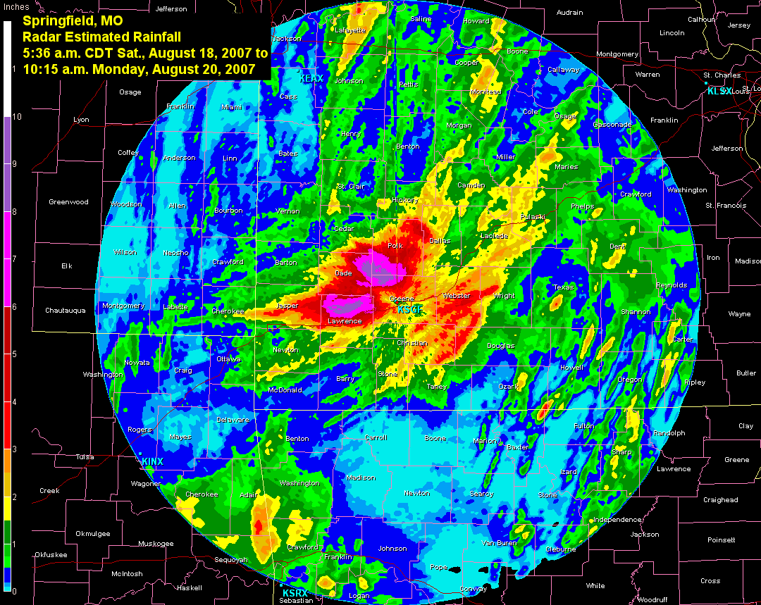
What remained of Tropical Depression Erin more directly affected Missouri on August 19-20. Showers and thunderstorms associated with the circulation began to move into southwestern Missouri late in the afternoon on August 19. Rain continued through the night and well into the morning on August 20 (Figure 15). The area of storms gradually diminished in areal coverage if not intensity during the afternoon. Radar estimated rainfall from this system was 8 to 10 inches northwest of Springfield , MO with a larger area of four to five inches over the western Ozarks (Figure 16). A volunteer weather observer in Miller, MO (Lawrence County) reported 11.94 inches of rain between midnight and 8:40 a.m. on August 20. Another observer in Dadeville (Dade County) reported a 24-hour total of 9.95 inches on August 20. The heavy rain produced widespread flash flooding with water flowing over numerous highways. A man was killed in Laclede County, MO when he drove into flood waters where a bridge had been completely washed out.
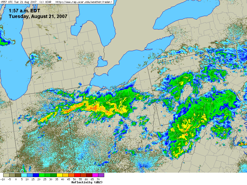
Heavy Rain and Flooding in Ohio, Indiana
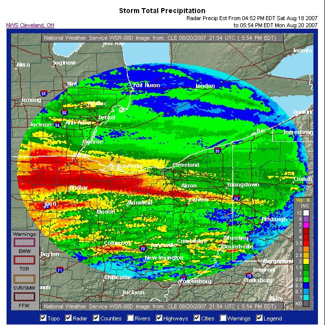
The focus of thunderstorms along the warm front in the Midwest on August 20 (Figure 17) shifted east into Indiana and Ohio. Thunderstorms first developed across northern Indiana and Ohio early in the day and moved south. By midnight another line of storms fired up from northeastern Indiana through northern Ohio (Figure 18). In a situation similar to that which occurred in Minnesota and Wisconsin two days earlier, heavy training thunderstorms (storms developing and moving repeatedly over the same areas) dumped more than 8 inches of rain on northern Ohio (Figure 19) and 3 to 5 inches across northern Indiana (Figure 20). By the morning of August 21, 9.35 inches of rain had accumulated in Upper Sandusky, OH (Wyandot County), and 8.68 inches was reported in Bucyrus, OH (Crawford County). The rain caused widespread flash flooding in the affected areas. Three to four feet of water was reported over many roads in northern Hardin County, OH. On the morning of August 21 the fire chief in Ottoville, OH (Putnam County) reported that 90 percent of the town was flooded by water two to three feet deep. On August 22 Ohio Governor Ted Strickland declared a state of emergency for nine Ohio counties affected by the flooding.
Severe Weather
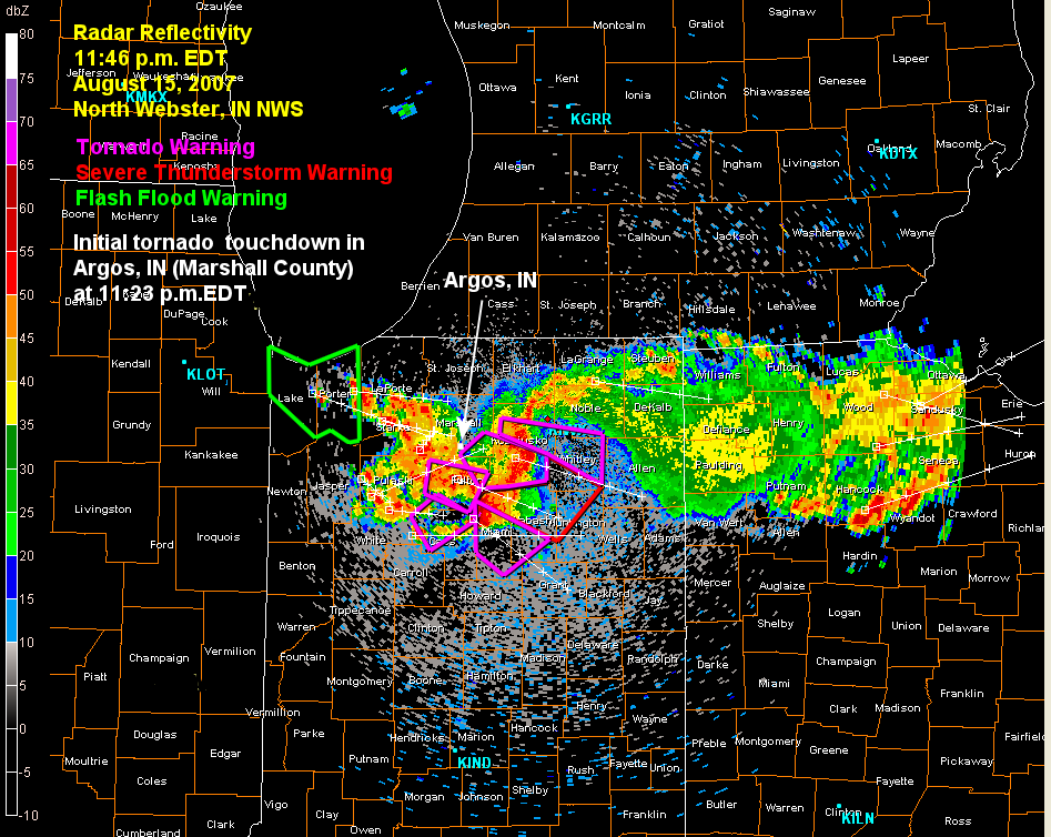
As if flooding weren't enough, the complexes of thunderstorms across the Midwest also produced some severe weather during the week. On August 15 severe thunderstorms pounded northern Indiana (Figure 21) with winds estimated at 100 mph, hail to one inch, and two tornadoes near Argos in Marshall County. In Iowa, 2.00 inch hail was reported in Scott County. On August 16 severe weather, mostly damaging winds, occurred ahead of the advancing cold front from western Illinois to southern Ohio. There was one report of 4.25 inch hail in Clark County, IN. On August 20 thunderstorms associated with the remnants of T.D. Erin spun up a weak tornado in Texas County, MO producing only minor damage.