May 25-31, 2006
Midwest Weekly Highlights - May 25-31, 2006
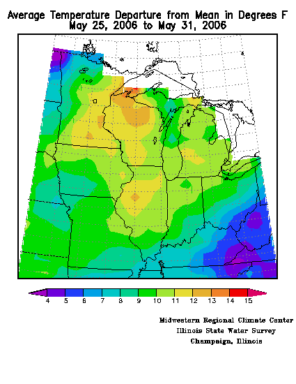
The final week of May ended with a memorable heat wave, intense thunderstorms, and flash flooding. The average daily temperature departures across the Midwest indicate that much of the region was significantly above average for this time of year, as many sites were at least 10°F above average (Figure 1). Average daily mean temperatures for the fourth week of May ranged from 4-7°F above normal across Kentucky and Ohio, to 9-12°F above normal across the remainder of the Midwest. The warmest state this week was Wisconsin, which carried the largest spatial extent of average daily temperatures that were 12-14°F above normal. Certainly this warm weather welcomed by many, as the first several weeks of May were at or below average in the temperature department.
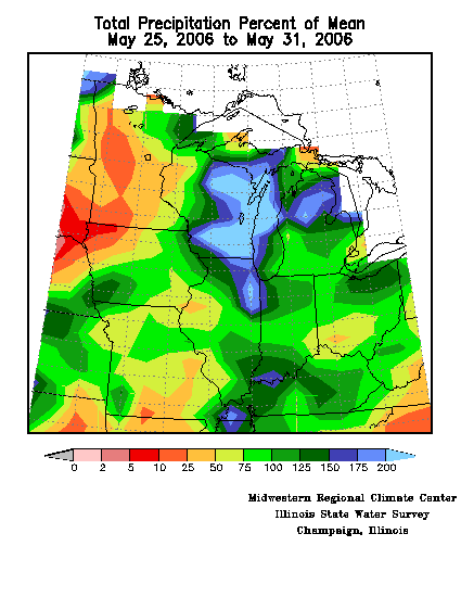
Precipitation for the
week was hard to come by if you lived in Minnesota, but generally
widespread and copious across Wisconsin, Illinois, Michigan, and southern
Indiana (Figure
2).
Precipitation deficits were again common across central and
southwestern Minnesota and extreme northwest Iowa where these portions
saw between 5 and 10% of normal precipitation. Heavy
thunderstorms, some severe at times, were prolific rain producers
further east, however, across northern Illinois and much of eastern
Wisconsin. Here, locations received between 150 and 200% of
normal precipitation for the final week of May. Other portions
that saw above normal precipitation included north central lower
Michigan and southern Indiana at 175% and 150% respectively. Western Illinois did not receive much in the way of
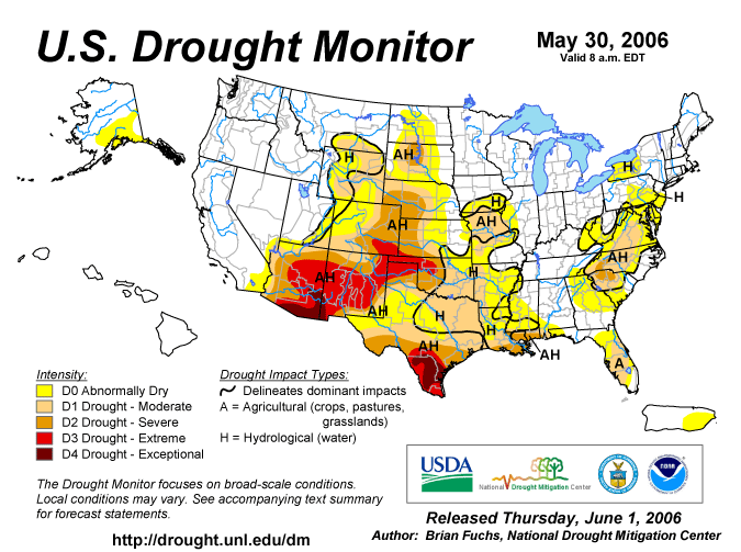
precipitation until May 31, so the drought monitor (Figure 3) reflects
an upgrade into D1 across this portion of the Midwest. Meanwhile,
drought was removed entirely from Wisconsin, Indiana, and Ohio this
week.
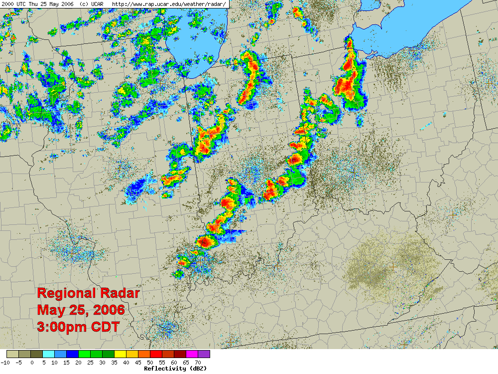
Several Rounds of Severe Thunderstorms
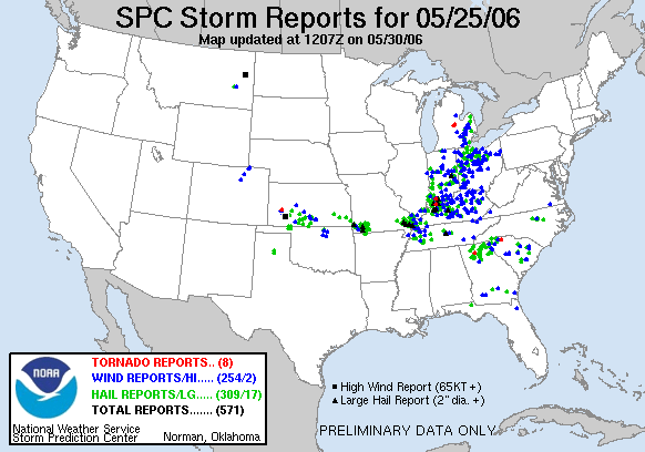
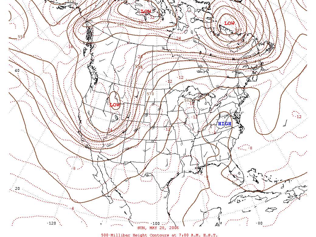
On May 25, a cold front moving southeast through the Midwest (Figure 4) sparked several severe thunderstorms, from Indiana through Michigan, Ohio, and Kentucky (Figure 5). There were over 500 reports of severe weather this day, many of which were concentrated across this portion of the Midwest (Figure 6). As the cold front moved its way through the Midwest, return southerly flow set in around high pressure that sank in behind the cold front. This allowed for the transport of warm and humid air into the Midwest, in combination with an upper level ridge of high pressure (Figure 7) setting the stage for warmer than average temperatures. However, the warm and humid conditions also set the stage for daily thunderstorms, which were aided at times by upper level pieces of energy. Throughout the period, there were hundreds of reports of downed trees and power lines across the Midwest, along with several reports of large hail breaking windshields and covering the ground, especially across Illinois and Indiana. Wind gust measurements were as high as 75 mph in the Chicago area over the Memorial Day weekend as slow moving thunderstorms blew up and then collapsed, sending their downdrafts rushing towards the surface. A few funnel clouds were also spotted with the collapse of these thunderstorms just about each day over the Holiday weekend, but fortunately no damage or injuries were reported. One sighting of a funnel cloud, and concomitant tornado warning, interrupted a graduation ceremony in Mt. Pleasant, MI on May 27. School officials tried to move people from the gymnasium to classrooms at the time of the warning, but some students decided to head outdoors instead. Incredibly, no injuries or structural damage were reported despite the dangerous situation.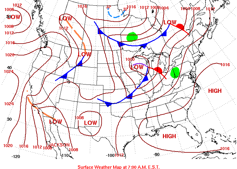
The slow moving thunderstorms were efficient rain producers, prompting numerous flash flood warnings across Illinois, Indiana, Michigan, Ohio, and Missouri at times between May 27 and 31, 2006. Unfortunately, in Leopold, IN, at least two persons were swept away by flash flooding near Oil Creek in the Hoosier National Forest. According to news reports, their truck was washed off the road when they tried to cross a flooded creek bed (which is apparently normally dry). Fortunately, the seven year old boy and his father were later found safely downstream. The boys grandfather, however, was not yet located.
The Heat is On!
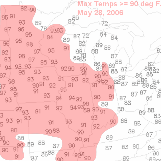
The Memorial Day Holiday weekend featured very warm, even hot temperatures across nearly each state in the Midwest! An upper level ridge of high pressure, which moved eastward from the western United States, brought many locales sunny skies and warm southerly breezes. This set-up was favored for record breaking high temperatures well into the 90's (Figure 8). The following table summarizes the expansive heat from May 27 to May 31, 2006. In all, there were an astounding 81 new record temperatures set during this period!!
| Date | Location | New Record | Old Record |
| May 27 | Moline, IL | 93°F (tie) | 93°F, 1978 |
| Burlington, IA | 93°F (tie) | 93°F, 1914 | |
| Lamoni, IA | 88°F (tie) | 88°F, 1991 | |
| Kansas City, MO | 94°F | 90°F, 1942 | |
| St. Joseph, MO | 93°F (tie) | 93°F, 1966 | |
| Springfield, MO | 88°F (tie) | 88°F, 1911 | |
| Joplin, MO | 90°F | 89°F, 1991 | |
| Joplin, MO | 72°F (high minimum) | 69°F, 1978 | |
| May 28 | Moline, IL | 95°F | 93°F, 1991 |
| Burlington, IA | 94°F | 90°F, 1929 | |
| Mason City, IA | 93°F | 92°F, 1980 | |
| Mason City, IA | 68°F (high minimum tie) | 68°F, 1991 | |
| Ottuma, IA | 93°F | 92°F, 1991 | |
| Waterloo, IA | 93°F (tie) | 93°F, 1998 | |
| Waterloo, IA | 70°F (high minimum) | 67°F, 1991 | |
| Lamoni, IA | 69°F (high minimum tie) | 69°F, 1991 | |
| Peoria, IL | 94°F | 93°F, 1914 | |
| Peoria, IL | 72°F (high minimum) | 70°F, 1941 | |
| Springfield, IL | 94°F | 93°F, 1911 | |
| Lincoln, IL | 94°F | 93°F, 1914 | |
| Rockford, IL | 93°F (tie) | 93°F, 1991 | |
| Rockford, IL | 69°F (high minimum) | 67°F, 1914 | |
| Chicago, IL (Midway, Arpt) | 94°F | 93°F, 1991 | |
| Chicago, IL (O'Hare Arpt) | 74°F (high minimum) | 72°F, 1941 | |
| Eau Claire, WI | 95°F | 94°F, 1934 | |
| Mankato, MN | 97°F | 94°F, 1969 | |
| Minneapolis, MN | 75°F (high minimum) | 70°F, 1969 | |
| St. Cloud, MN | 71°F (high minimum) | 68°F, 1934 | |
| Eau Claire, WI | 72°F (high minimum) | 68°F, 1929 | |
| Rochester, MN | 95°F | 93°F, 1934 | |
| Rochester, MN | 71°F (high minimum) | 67°F, 1991 | |
| La Crosse, WI | 73°F (high minimum tie) | 73°F, 1874 | |
| Marshfield, WI | 90°F | 89°F, 1998 | |
| Stevens Point, WI | 91°F | 90°F, 1929 | |
| Wisconsin Rapids, WI | 92°F | 91°F, 1998 | |
| Madison, WI | 70°F (high minimum) | 67°F, 1914 | |
| Muskegon, MI | 86°F (tie) | 86°F, 1991 | |
| Alpena, MI | 91°F | 90°F, 1986 | |
| London, KY | 89°F | 88°F, 1987 | |
| Paducah, KY | 91°F | 90°F, 1993 | |
| Paducah, KY | 73°F (high minimum) | 68°F, 1954 | |
| Kansas City, MO | 93°F | 92°F, 1998 | |
| St. Joseph, MO | 93°F | 92°F, 1926 | |
| St. Louis, MO | 93°F (tie) | 93°F, 1991 | |
| Joplin, MO | 73°F (high minimum) | 70°F, 1956 | |
| Springfield, MO | 70°F (high minimum tie) | 70°F, 1908 | |
| Rolla/Vichy, MO | 70°F (high minimum tie) | 70°F, 1991 | |
| West Plains, MO | 68°F (high minimum) | 66°F, 1956 | |
| May 29 | Moline, IL | 74°F (monthly high minimum tie) | 74°F, 1914 |
| Waterloo, IA | 72°F (high minimum tie) | 72°F, 1942 | |
| Ottumwa, IA | 73°F (high minimum tie) | 73°F, 1942 | |
| Minneapolis, MN | 94°F | 91°F, 1988 | |
| Minneapolis, MN | 74°F (high minimum) | 69°F, 1895 | |
| Eau Claire, WI | 94°F (tie) | 94°F, 1934 | |
| Eau Claire, WI | 70°F (high minimum tie) | 70°F, 1929 | |
| Marshfield, WI | 89°F (tie) | 89°F, 1934 | |
| Wausau, WI | 90°F | 88°F, 1986 | |
| Rochester, MN | 95°F | 94°F, 1934 | |
| Rochester, MN | 72°F (high minimum) | 65°F, 1991 | |
| La Crosse, WI | 95°F (tie) | 95°F, 1934 | |
| La Crosse, WI | 75°F (high minimum) | 74°F, 1895 | |
| Madison, WI | 71°F (high minimum) | 70°F, 1929 | |
| Milwaukee, WI | 70°F (high minimum) | 67°F, 1895 | |
| Gaylord, MI | 91°F | 89°F, 1978 | |
| Traverse City, MI | 93°F | 92°F, 1978 | |
| Detroit, MI | 92°F (tie) | 92°F, 1987 | |
| Marquette, MI | 93°F | 92°F, 1986 | |
| Marquette, MI | 68°F (high minimum) | 64°F, 1987 | |
| Sault Saint Marie, MI | 89°F (tie) | 89°F, 1895 | |
| Muskegon, MI | 70°F (high minimum) | 66°F, 1991 | |
| Lansing, MI | 70°F (high minimum tie) | 70°F, 1991 | |
| Toledo, OH | 93°F (tie) | 93°F, 1962 | |
| Jackson, KY | 89°F (tie) | 89°F, 1987 | |
| Columbia, MO | 91°F (tie) | 91°F, 1926 | |
| May 30 | Alpena, MI | 93°F | 92°F, 1988 |
| Youngstown, OH | 89°F | 88°F, 1988 | |
| Mansfield, OH | 89°F (tie) | 89°F, 1988 | |
| Jackson, KY | 90°F | 87°F, 1988 | |
| London, KY | 91°F | 88°F, 1969 | |
| May 31 | Jackson, KY | 91°F | 89°F, 1991 |
| Youngstown, OH | 88°F (tie) | 88°F, 1944 |