January 1-10, 2005
Midwest Weekly Highlights - January 1-10, 2005
The New Year Starts With Snow, Ice, Rain, and Floods
A strong and persistent upper air trough on the West Coast resulted in the first 10 days of January
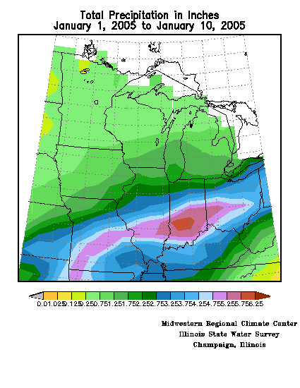
2005 being warmer and wetter than normal in most of the Midwest. Precipitation totals were 3-6
inches in Missouri, Illinois, Indiana, Kentucky, and Ohio (Figure 1). Even in areas with less total
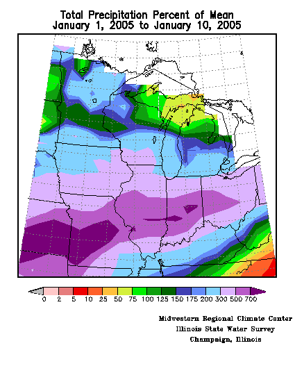
precipitation, amounts were still above normal for the time of year everywhere but in northern
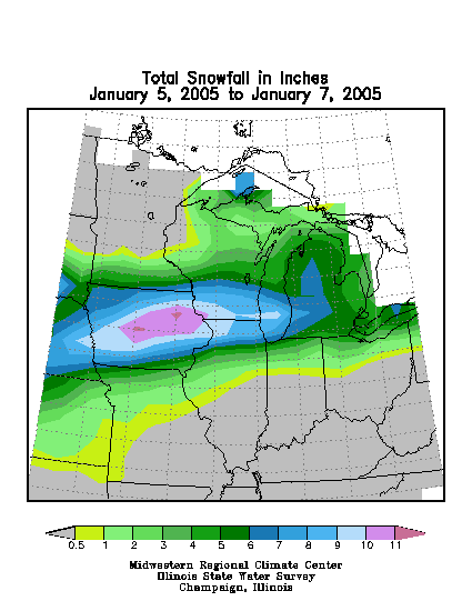
Michigan, and in many places in the southern Midwest exceeded 300% of normal (Figure 2).
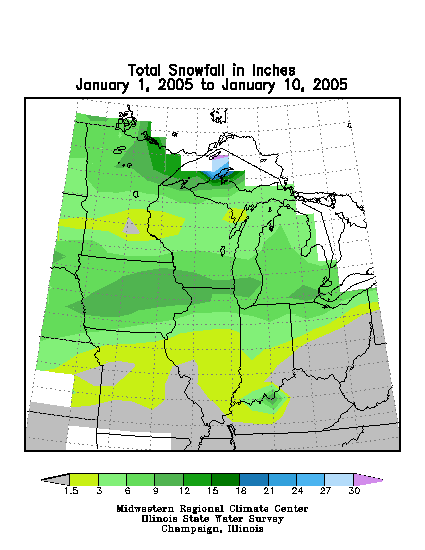
Most of the precipitation in question was liquid, although a substantial band of snow was
deposited from Iowa through the southern Great Lakes region (Figure 3). Abundant snow also
fell further north near western Lake Superior due to a low pressure center passage; however, the
lake effect belts were not active snow producers during this period due to the lack of cold air
advection from the north. Even more problematic was the severe icing that took place in eastern
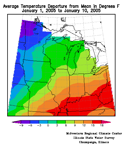
Iowa, northern Illinois, and northern Indiana on the 5th. Temperatures for the period were cooler
than normal (-3 to -6°F) in the northwestern portion of the region, but most of the Midwest was
very warm, exceeding 15°F above normal in Kentucky (Figure 4). The warmth melted the
substantial snow amounts deposited in the Ohio Valley in December, and heavy precipitation
provided more runoff, swelling the rivers past flood stage in many locations in Illinois, Indiana,
Ohio, and Kentucky.
Triple-Barrel Winter Assault on the Midwest: Ice, Snow, and Flooding Rains
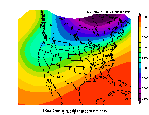
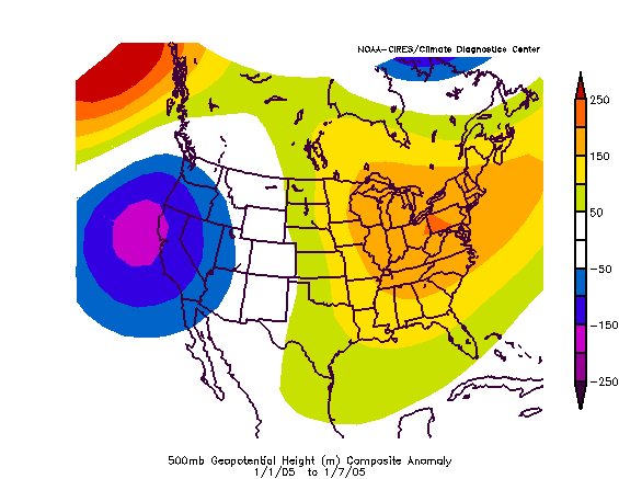
During the first week of January, the persistent southwesterly flow pattern in the mid-troposphere over the conterminous U.S. brought a series of storms and warm and moist air into the southern Midwest (Figure 5a, Climate Diagnostic Center - CDC). The trough and ridge anomalies were unusually strong for the time of year (Figure 5b, CDC). After a clipper system passage through the northern Midwest on the 1st, reinforcing cold air moved in north of the frontal boundary with the unseasonably warm air to the south, creating a sharp temperature gradient. Four locations in Missouri and two in Kentucky set new records for warmest minimum temperatures, and Springfield and Joplin, MO, set new records for maximum temperature of 70°F and 69°F, respectively. Considerable snow fell in northern Minnesota, with Duluth, MN, setting a daily record of 9.5 inches. Moderate amounts of icing (less the 0.5 inches) occurred in narrow bands in Minnesota and Wisconsin, and over a broader area of northern Michigan. Rain fell further south, including the first severe weather report of the year in the Midwest, some 0.75 inch hailstones observed in Beardstown, IL. On the 2nd, another 7 locations in Missouri, Kentucky, and Indiana set or tied new record warm minimum temperatures.
Icing:
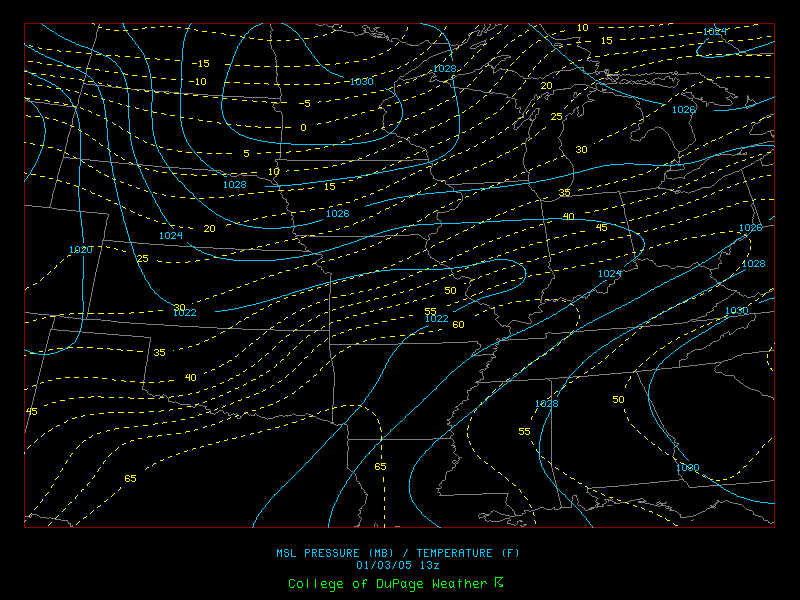
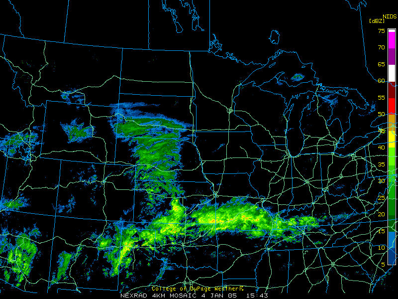
By the 3rd, the southernmost reaches of the Midwest were already above 60°F
in the mid-morning, contrasting sharply with sub-freezing temperatures to the
north that had pushed southward the previous day (Figure 6, College of DuPage - COD). This quasi-stationary
boundary running from Missouri to Ohio would be the focus of disturbances moving along the
front for several days. Since the disturbances follow the front, moisture ahead of each low was
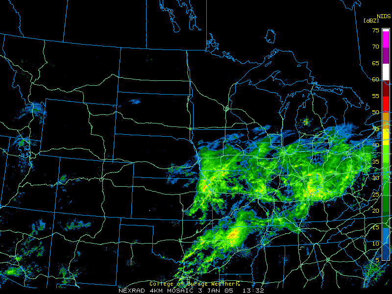
raised over the cold surface air in the central Midwest (Figure 7, COD). The result of this pattern
was a triple-barrel assault of snow, icing, and heavy rain on the Midwest. Some moderate icing
occurred in parts of Missouri, and Iowa on the 3rd, but it was only the beginning of a much more
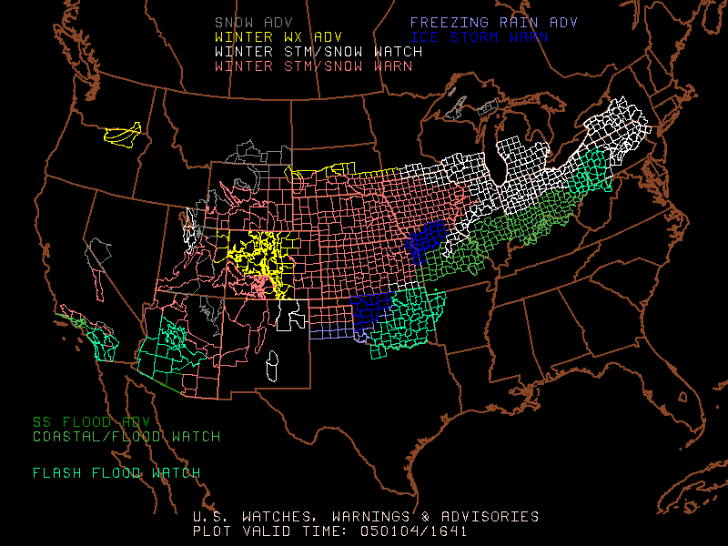
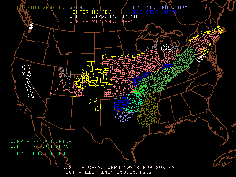
serious icing event on the 4th and 5th. Weather warnings show the initial ice storm locations on
the 4th (Figure 8a, NWS), and the extension of this area over northern Missouri and Indiana on
the 5th (Figure 8b, NWS). In addition to the ice storm warning areas (in blue) substantial icing
occurred in the southern parts of the winter storm warning areas (in red). Flood watches and
warnings (in green) also extend from southwestern Missouri through the Ohio Valley.
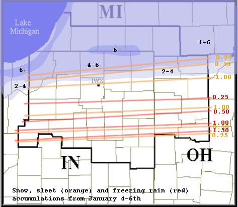
The heaviest freezing rain started on the morning of the 4th (Figure 9, COD) near Witchita, KS, which was encased in 0.5-1.5 inches of ice over the next 36 hours. More than 94,000 customers lost power at the height of the storm effects. The next major site of icing was in the Kansas City area (KS and MO), were 60,000 customers of regional utilities lost power as more than 1 inch of glaze caused tree limbs to snap and fall on power lines. Central Illinois was somewhat hard hit, with 11,000 residents in several counties loosing power. Finally, another zone of heavy icing occurred in northern Indiana and Ohio, where over 1.5 inches of ice were deposited in places (Figure 10, NWS), enough not only to bring down trees, but also snap power lines directly. Over 180,000 customers lost power in the north-central part of Indiana. About 114,000 of these power outage victims were in an area centered on Muncie, IN. About 179,000 homes and business lost power in Ohio at the peak of the storm effects. Overall, scattered outages of power occurred all the way from Kansas City to northwestern Ohio, and recovery took a long time in the worst impacted zones. In the Muncie area alone, more than 50,000 were still without power 5 days after the ice storm on January 10.
Snow:
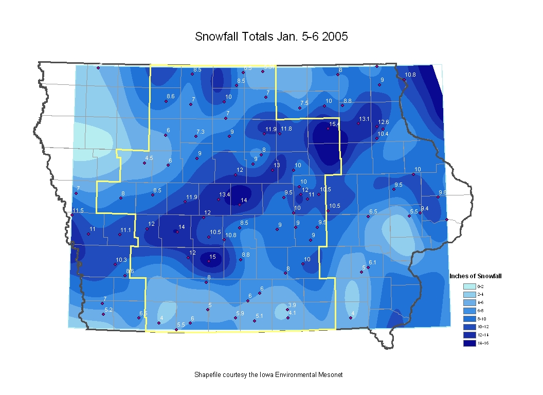
Snow was the big story north of the icing line. A large swath of snow was deposited from Iowa
to southern Michigan on January 4-6 (Figure 11). Individual station totals exceeded 10 inches in
many locations in Iowa (Figure 12, NWS). Des Moines, IA, received 14.6 inches of snow, and
most schools were closed for three days due to the earlier icing combined with the large snowfall.
In northern Illinois and southern Wisconsin, snowfall totals were in the 6-10 inch range, although
a few sites near Chicago also exceeded the 10 inch level, including 14 inches at Gurnee, IL.
O'Hare International Airport received 9.6 inches of snow over the January 4-6 period, and more
than 1,000 flights were canceled on the 5th alone. Midway Airport in downtown Chicago had
128 flight cancellations. Ground transportation was also disrupted severely by snow throughout
Iowa, southern Wisconsin, northern Illinois and southern Michigan. North of the snow band,
many places were still waiting for snow at the end of the period. At Minneapolis/St. Paul, MN, a
new record was set on January 10 for the latest day in the snow season in 114 years without a 1
inch snow fall. It has been cold enough for snow, with below normal temperatures across most
of the state during the period, including tying the minimum temperature record of -34°F for
International Falls on the 5th.
Rain and Floods:
Despite the ice and snow, rain and snow melt were really the most important story for the period.
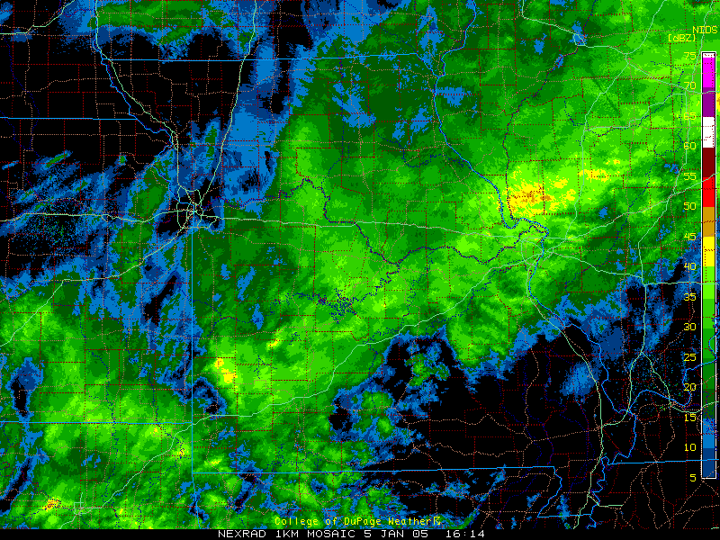
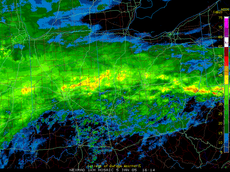
By the 5th, a fire hose of moisture was entering the region from the south, dropping heavy
precipitation all along a frontal boundary from Missouri (Figure 13a, COD) to Ohio (Figure 13b,
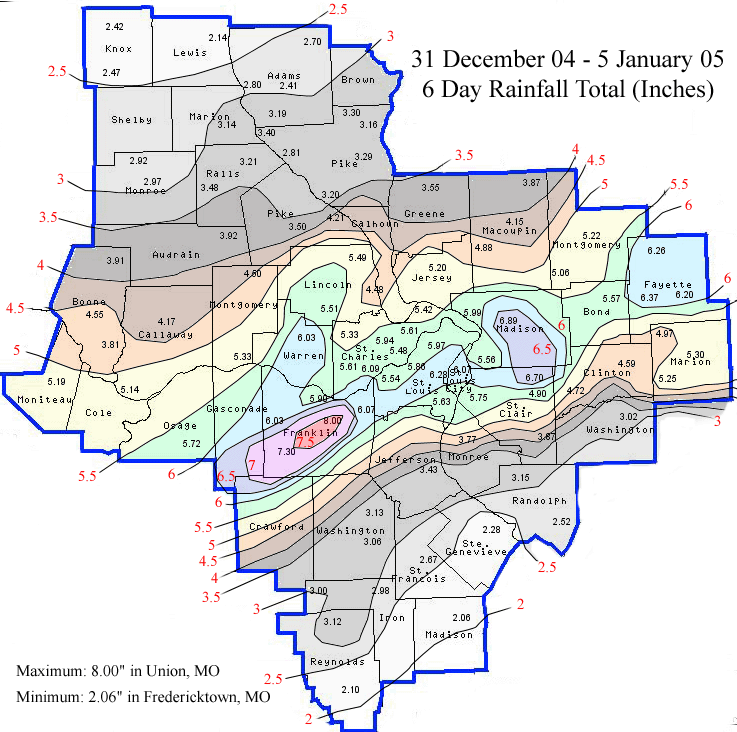
COD). The western part of the precipitation swath through the St. Louis area reached a
maximum of 8 inches (Figure 14, NWS), and St. Louis itself set an all time record of 5.85 inches
of accumulated precipitation for the first five days of January. This amount was equivalent to the
5th wettest January on record, with 26 days left in the month. The precipitation was even heavier
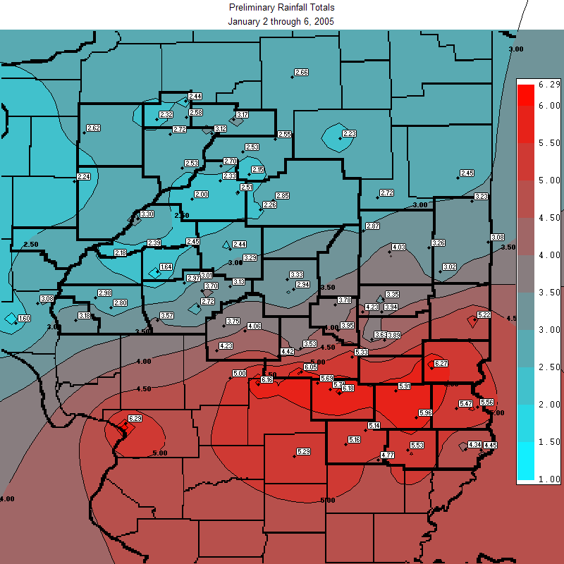
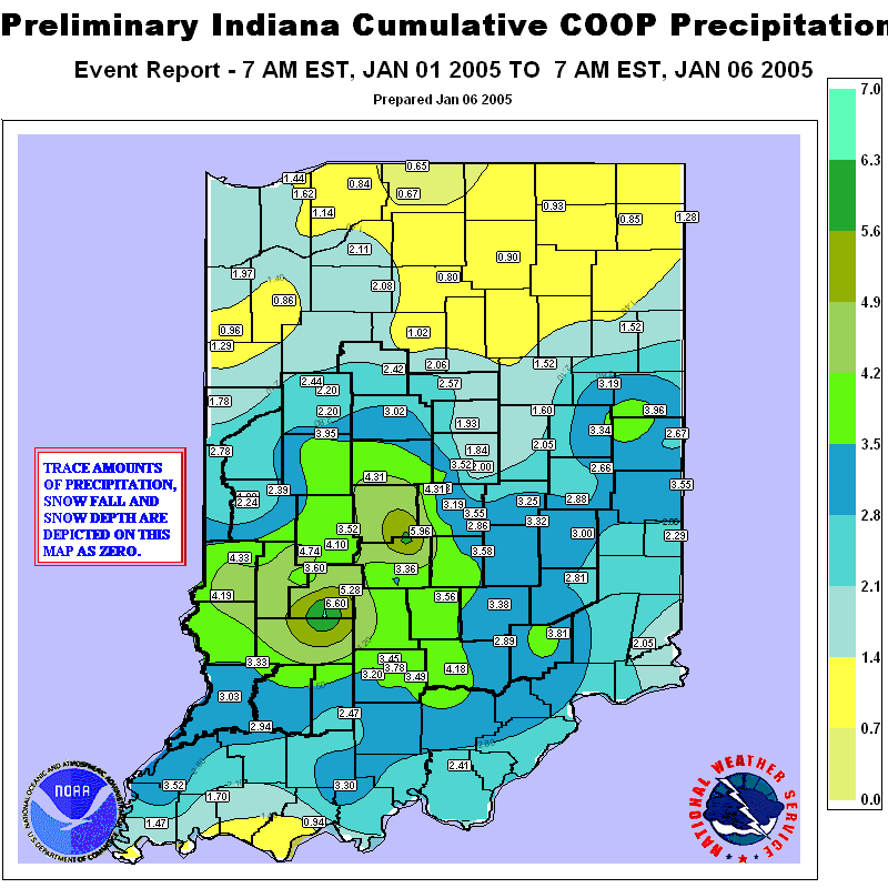
to the east of St. Louis, especially in southern Illinois (Figure 15, NWS), and southern Indiana
(Figure 16, NWS). These amounts and rates of precipitation would not have been possible
without temperatures in the 50s and 60s throughout the core of the rain event on January 4-6.
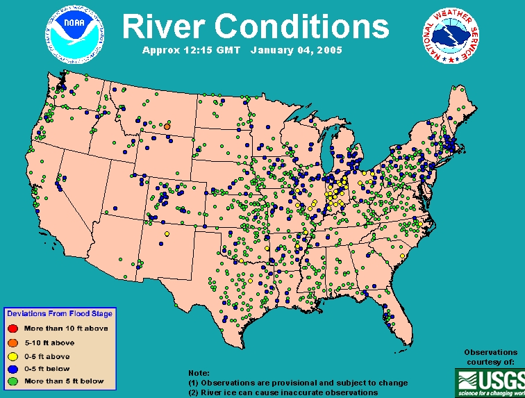
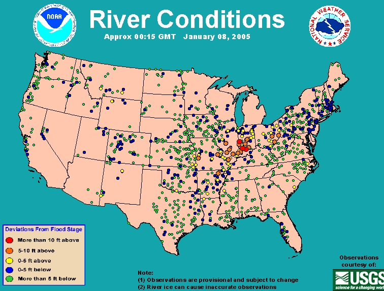
River levels went from slightly above flood stage on the 4th (yellow dots in Figure 17a, NOAA),
to widespread major flooding on the 8th (orange and red dots in Figure 17b, NOAA). Even for
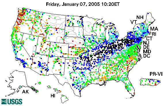
those rivers not at flood stage, stage heights were still higher than ever recorded at this time of
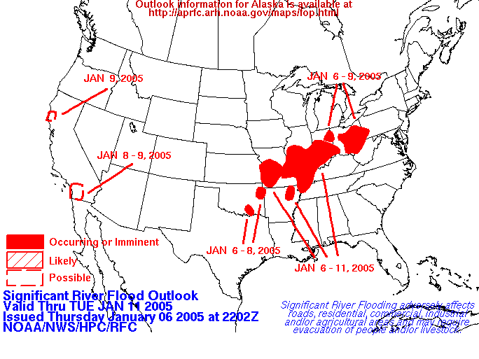
year (black dots in Figure 18, US Geological Survey - USGS). Widespread flash flooding
occurred through the region during and shortly after the heavy rain period, but the emphasis
turned to medium and large river flooding later in the period (Figure 19, NOAA). Some heavy
rain occurred in Kentucky on the 7th, and the rest of the southern Midwest remained mild for
several more days, with fog causing major problems over central Midwest snow and ice covers.
Conditions cooled at the end of the period briefly.
By the end of the period, a number of regional-scale and large-scale river systems were experiencing moderate to major flooding in the Midwest. In Illinois, the Iroquois, Kaskaskia, Embarras, Sangamon, Big Muddy, and Illinois Rivers were the sites of the worst flooding. In Indiana, the Saint Marys, the White and its East Fork, and the Wabash were the primary loci of flood activity, although many smaller rivers were also affected. In Ohio, the Scioto, Mahoning, Muskingum, Great Miami, and others were flooding, along with the namesake regional river, the Ohio. Flooding also occurred elsewhere in the Midwest, including near rain-swollen rivers in Missouri and Kentucky, and along ice-jammed rivers in Michigan. The flood hydrographs for these rivers will be included in the next report.
Weather-Related Deaths:
Prior to the major storm, two people died and many were injured on the 1st in southern
Wisconsin due to icing on the roads overnight. At least 15 weather-related deaths were reported
during the time period due to the major storm on January 3-6. Most of the deaths were on the
cold side of the storm in the central and northern Midwest, linked to slippery road conditions or
snow removal. Two people died after sliding off a road in western Iowa on the 3rd. Four
fatalities were recorded in the Chicago area and three people died in Michigan due to heart
attacks while clearing snow on the 6th. In southeast Michigan on the 6th, two fatal traffic
accidents appear to have been related to road conditions. One person slid across a curve into
oncoming traffic and was killed in northern Indiana the same day. There were countless near-misses and minor injuries along the highways. Another danger impacted 22 people who were
treated at hospitals in Madison County, IN, alone for carbon monoxide poisoning. This county
had extensive power outages due to icing, and dangerous heat sources were used indoors.
On the warm side of the storm, two people were swept away in a car that entered a flash flood in southwestern Missouri, one was swept off a flooded bridge in southern Illinois, and 4 people operating a tug boat on the Ohio River near Pittsburgh, PA, were drowned when their boat was driven against a dam by fast currents and submerged. Again, there were numerous cases of boats and emergency personnel being used to rescue people from ill-advised driving decisions, or from homesteads that were rapidly surrounded by flood waters.