August 22-31, 2015
Midwest Weekly Highlights - August 22-31, 2015
Dry Week for Many, But Not All
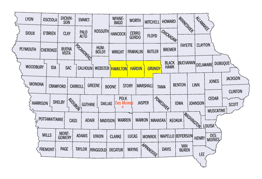
It was a dry end to what was one of the wetter summers on record in the Midwest as only a few areas of the region observed above normal precipitation for the period (Figure 1). Storms dropped heavy rain in Iowa and southern Wisconsin on August 27 (Figure 2) through the morning of August 29 (Figure 3). Over an inch of rain fell across the area while isolated spots in central Iowa had upwards of four inches of rain in the 24 hour period through the morning of August 29. Grundy Center in Grundy County had 4.27 inches that day while Webster City in Hamilton County observed 4.14 inches. Three sites in Hardin County had more than four inches of rain with Iowa Falls recording 4.11 inches, Eldora seeing 5.66 inches and Steamboat Rock observing 6.43 inches.
Dry to very dry conditions were in place across Iowa, Indiana, Kentucky and Missouri where most areas had less than half the normal amount of precipitation for the period (Figure 4). Most of Minnesota and northern Wisconsin also saw less than half the normal amount of precipitation. Parts of west-central Illinois, southern Indiana, and north central Kentucky were nearly dry, leading to departures of over an inch below normal (Figure 5).
Cool End to August
Temperatures dove well below normal to end the month of August as the entire region spent the period cooler than normal (Figure 6). Average temperatures were mainly in the upper 50s to low 60s in the upper Midwest and Great Lakes while temperatures were barely able to get above 70°F in Kentucky and southern Missouri
(Figure 7). Iowa had the most below normal temperatures for the period with most of the state 5-7 degrees below normal. The rest of the region averaged temperatures 2-5 degrees below normal.
Drought Worries Lessen
While moderate drought conditions were sustained in the latest drought monitor through August 25 in southwest Wisconsin and the Arrowhead of Minnesota, above normal rainfall over the last half of August has helped ease concerns (Figure 8). Southwest Wisconsin had upwards of 3 inches of rainfall since August 15, leading to up to one and half times the normal amount of rainfall (Figure 9). Storms in the Minnesota Arrowhead also dropped around 3 inches, leading to over one and a half times the normal amount of rainfall for that period
(Figure 10). While these areas still remain well below normal since the start of July, the rainfall is welcome to these areas (Figure 11).
-BJP-