June 8-14, 2015
Midwest Weekly Highlights - June 8-14, 2015
Wet Week for Central Midwest
After a mostly dry first week of June, abundant rain fell across the central Midwest this week
(Figure 1). A moist airmass sat over the region, leading to showers and thunderstorms every day. Illinois and northern Indiana were hit the hardest, seeing 3-6 inches of precipitation for the week. With mean precipitation for the period only around 1 inch (Figure 2), most of these areas saw 3-5 times the normal amount of precipitation
(Figure 3). Meanwhile, Minnesota had a mostly dry week for the first time since April, with departures of up to 1 inch in most areas. Most of Missouri was within an inch of normal while the Ohio Valley was slightly below normal.
Warm Weather Returns
While June started out cold for most of the Midwest, a warm, moist airmass this week brought above normal temperatures back into the region (Figure 4). Average temperatures across Missouri, Kentucky and southern parts of Illinois and Indiana were in the low 80s
(Figure 5), which led to departures of 4-7°F above normal across these states. Ohio and northern Minnesota also saw departures of up to 5°F above normal. Iowa, Wisconsin and southern Minnesota were all near to slightly above normal while northern Michigan and the U.P. skewed slightly below normal. There were a couple of very hot days in this period on June 9 (Figure 6) and June 10
(Figure 7) (observations taken the next morning) where high temperatures in the mid to upper 90s were seen across the western portions of the region. This is well above the average temperature of the upper 70s and low 80s for these days (Figure 8).
Severe Weather Summary
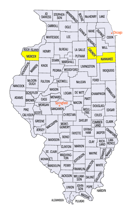
With a warm, moist airmass in place, severe weather was almost inevitable across the region (Figure 9). Every day had at least five severe weather reports in the region. Hail fell across the Chicagoland area on June 8, while wind damage was prevalent across Kentucky. Hail and wind laid its mark on southwest Minnesota on June 9 as another system entered the region, leading to more strong storms in southern Iowa through northwest Ohio on June 10. Giant hailstones fell on Minooka, IL in Grundy County that day, with the largest hailstone measuring 4.75 inches! This is the second largest hailstone ever recorded in the state of Illinois, with the largest being a 6 inch diameter hailstone from Kankakee County, IL in 1961.
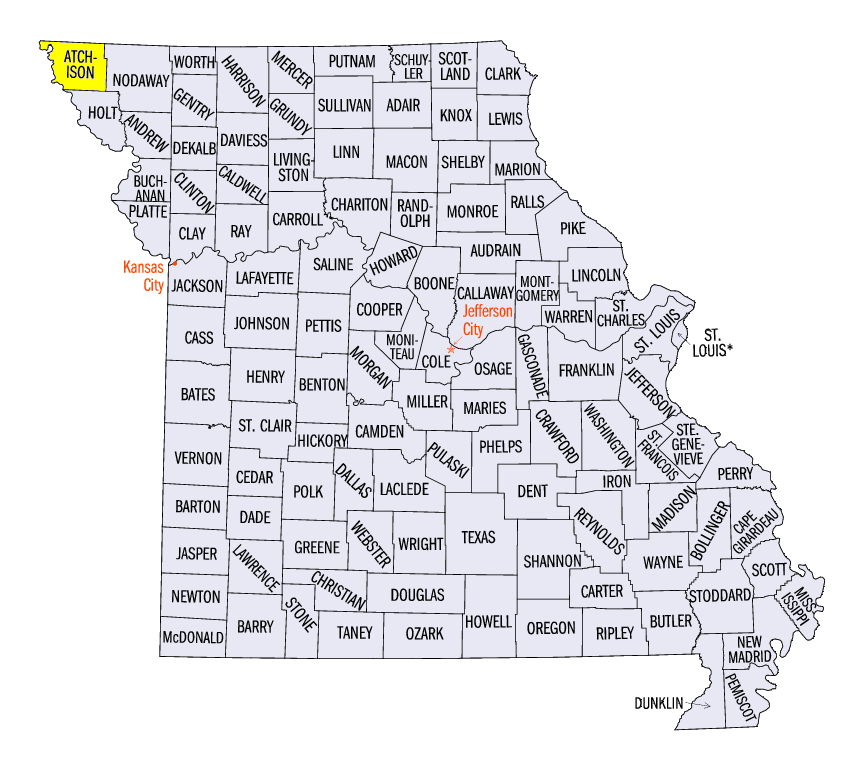
The relentless onslaught of severe weather continued on June 11th, where the only tornadoes of the week were sighted in northwest Missouri and northwest Illinois. An EF-1 tornado caused damage near Matherville, IL in Mercer County while brief touchdowns were seen in Atchison County, MO. Strong winds pummeled Indiana and Ohio on June 12 with a line of storms causing damage through central Illinois and Missouri as well. More wind damage was reported on June 13 in Illinois, Missouri and the Indiana, Ohio & Michigan tri-state area before calming down on June 14th to only a few isolated reports. In all, hundreds of reports were made on what was clearly one of the most active weeks of severe weather this year.
Midwest Drought Vanishes
Good news came this week for the Midwest as drought conditions have completely vanished from the region for the first time in 2015, according to the latest drought monitor (Figure 10). Heavy spring and early summer rain has left only areas of abnormally dry conditions across the upper Ohio Valley, eastern Michigan and northern Minnesota and Wisconsin. Unfortunately, too much rain has fallen in some places, and flood concerns are mounting.
Flooding Concerns Rising
With flood warnings already in place along the Missouri River for the past few weeks, more rivers moved above flood stage this week across the Midwest (Figure 11). With areas of northern Illinois receiving more than 4 inches of precipitation above normal this week, the Kankakee and Illinois Rivers flooded. The Mississippi River is also near or above flood stage along most of the Illinois border. Heavy rain in Indiana also stressed the Wabash River for most of the week. Flash flood watches and warnings were issued often during the week in northern and central Illinois, where slow moving storms, with rainfall rates around an hour, repeatedly led to flash flooding.
Unfortunately, the forecast calls for more rain in already drenched areas of the region. This warm, moist airmass is expected to stay in place for another week while a tropical disturbance is forecast to add more moisture to the airmass. Up to 8 additional inches of rain could fall in parts of the region this week (Figure 12), with locally higher amounts possible. Stay flood safe by preparing yourself for the effects of flooding and read more on floods and flood safety from our Living With Weather page on Floods. Turn Around, Don’t Drown!
-BJP-