April 22-30, 2015
Midwest Weekly Highlights - April 22-30, 2015
Cool Down to End the Month
After an above normal first three weeks of April
(Figure 1), the month ended on a cool note as Canadian air became more of an influence on the weather pattern across the Midwest (Figure 2). Temperatures were near to 5°F below normal across the western portions of the region, while 5-10°F below normal temperatures were common across the eastern half. The coldest areas were in Ohio and Indiana, where 8-10°F below normal average temperatures were seen. Low temperatures on April 23
(Figure 3) and April 24 (Figure 4) also prompted freeze warnings in Illinois, Indiana, Michigan and Ohio as temperatures in the low 30s and high 20s occurred both mornings. Lows on April 24th were by far the coldest in these areas, and were 12-18°F below normal
(Figure 5).
Dry Week
While the first three weeks of April proved to be wet for most (Figure 6), dry conditions took over to end the month
(Figure 7). Southern portions of the region were an inch or more of precipitation below normal. Areas currently experiencing drought in Minnesota and Wisconsin added 0.50-1.00 inches to the precipitation deficit as most of these areas saw less than 25 percent of the normal rainfall for the period (Figure 8). A small portion of the region received near normal precipitation this week in northern Illinois and Indiana, but no major areas had above normal precipitation across the region.
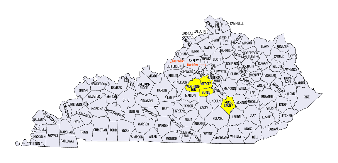
Kentucky Severe Weather April 25
A line of thunderstorms moved through far southern Illinois and Kentucky on April 25, spawning a few tornadoes and numerous hail and wind reports. A short-lived EF-0 tornado was recorded in Henderson County, KY along with a phenomenon called a microburst
(Figure 9). The microburst created a peak straight-line wind of 100 mph according to a NWS-Paducah survey. One person was injured by the event. Large hail fell on eastern Kentucky as the line of thunderstorms advanced through the afternoon. The largest report was for 3-inch diameter hail in Danville, KY, located in Boyle County. These four counties all reported 2 inch diameter hail or larger during the afternoon. Only one other report, a hail report in southwest Missouri, was submitted throughout the rest of the period.
Drought Worsens in Minnesota
After yet another dry week in Minnesota, the National Drought Mitigation Center added Severe Drought conditions to the northwest part of the state in its latest drought monitor (Figure 10). Well below normal precipitation for the water year so far is one of the major factors in adding severe drought to this area (Figure 11). Many areas in western Minnesota have had less than half of normal precipitation since October 1 (Figure 12). However, the dry spring has helped farmers start planting crops earlier this season, and rains over the next few months could make growing conditions favorable.
-BJP-