November 22-30, 2016
Midwest Weekly Highlights - November 22-30, 2016
Wetter Weather
Wet conditions were prevalent across the Midwest as a storm dropped more than an inch of precipitation across large portions of the region
(Figure 1). While the main low pressure system was located in Minnesota and the Dakotas and brought more than an inch of precipitation to Minnesota and Iowa through the morning of November 28 (Figure 2), a stalled cold front over Wisconsin, Illinois and Indiana dumped more than 1.50 inches of rain through the morning of November 29
(Figure 3). As the front slowly moved east, parts of eastern Kentucky received much-needed rainfall through the morning of November 30 and helped to extinguish some of the wildfires that were occurring (Figure 4). In many cases, the precipitation was one-and-a-half to two times the normal amount
(Figure 5). However, two Midwest states, Missouri and Ohio, had below-normal precipitation for the period (Figure 6). While most of the precipitation that fell during the period was rain, snowfall was common in the Upper Midwest
(Figure 7). Five inches of snow fell across the western U.P. of Michigan. Ironwood, MI (Gogebic County) recieved 8.9 inches during the period, with 8.0 falling through the morning of November 24. Nearly eight inches fell near Michigamme, MI (Baraga County) as well.
Warm End to a Warm November
Temperatures were once again above normal across most of the Midwest (Figure 8). Northern Minnesota was the warmest area in the region, with temperatures 8-13°F above normal. Southern Minnesota, western Wisconsin and Iowa were 5-8°F above normal. Most of Michigan was 2-5°F above normal, while Indiana, Ohio and northern Illinois were only a few degrees above normal. Near-normal conditions were common across the southern portions of the region, with southern Illinois and half of Kentucky within a degree of normal.
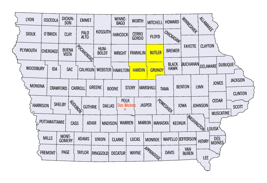
November 28 Iowa Tornadoes
Three weak tornadoes were confirmed by National Weather Service surveys in central Iowa from storms on November 28
(Figure 9). An early afternoon EF-0 tornado touched down near Radcliffe (Hardin County) around 12:45 local time. Two tornadoes occurred later that afternoon around 3:45 local time, an EF-0 tornado near Parkersburg (Butler County), and an EF-0 tornado near Grundy Center (Grundy County). No injuries were reported from these tornadoes, which all had estimated peak winds of 70-75 mph.
Kentucky Drought Worsens
Drought remained a major concern across Kentucky, as 98% of the state was classified in drought as of the November 29 Drought Monitor (Figure 10). Nearly 90% of the state was considered to be in severe or worse drought, with almost a quarter of the state in extreme drought. Drought conditions have expanded rapidly this fall across Kentucky (Figure 11). Meanwhile, moderate drought was also located in parts of extreme southern Indiana and Ohio, while the Missouri Bootheel was considered to be in severe drought. Nearly five million people in the Midwest were estimated to be living in drought stricken areas.
-BJP-