November 15-21, 2016
Midwest Weekly Highlights - November 15-21, 2016
Record Warmth to Freezing Temperatures
Temperatures were above normal across the Midwest for the weekly average (Figure 1). However, two distinct patterns occurred: an unusually warm first half of the week, and a chilly second half. Temperatures were more than 8°F above normal across most of the region from November 15-18 (Figure 2). Record high maximum temperatures were common on November 16-18, where more than 300 new daily records were set. More than 200 of those occurred on November 17, as temperatures reached the 70s across the southern half of the region (Figure 3).
The second half of the week was below normal across almost all of the region (Figure 4). Widespread minimum temperatures in the 20s and teens occurred for the first time during the Fall on the morning of November 19
(Figure 5). Areas that had not yet received their first fall freeze finally had temperatures below freezing, with some stations setting new latest first fall freeze records (Figure 6). Average temperatures across most of Illinois, Kentucky and Indiana was 5-9°F below normal, while the remainder of the region was mainly 2-5°F below normal. Extreme northwestern Minnesota was the only exception, where average temperatures were slightly above normal.
Dry Conditions, Except in Minnesota
Dry weather was common across most of the Midwest as only one major storm occurred during the week
(Figure 7). Less than an inch of precipitation fell across the eastern half of the region, while most of Iowa, northwestern Illinois and northern Missouri was completely dry. Most of Illinois, Kentucky, Ohio and Lower Michigan had less than half the normal amount, while Indiana mainly had less than 75% of normal (Figure 8). The only area with above-normal precipitation was in Minnesota, where more than twice the normal amount fell in the form of snow during a winter storm on November 18-20.
November 18-20 Winter Storm
A strong storm on November 18-20 had wide-ranging impacts on the entire Midwest, including a blizzard in Minnesota, severe weather in Indiana and Michigan, and high winds and large temperature swings across the rest of the region.
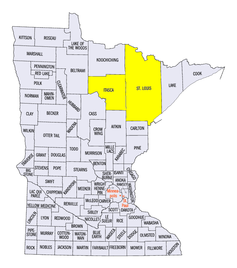
Minnesota Blizzard
Strong winds and heavy snow blanketed Minnesota on November 18-19, which resulted in a blizzard in parts of the state. Snow first began to fall in northern Minnesota overnight through the morning hours of November 18 (Figure 9). Four to six inches of snow then fell across southwestern Minnesota, while 6-10 inches fell across north-central Minnesota through the morning of November 19 (Figure 10). More than a foot of snow fell in areas near the Canadian Border. Some of the heaviest two-day snow totals included 20.8 inches in Keewatin (Itasca County), 24.8 inches near Orr (St. Louis County) and 21 inches near Celina (St. Louis County). Strong winds gusting from 45-55 mph led to whiteout conditions across central and northern Minnesota and caused hundreds of vehicle crashes. Two people were killed in separate car crashes according to the Minnesota State Patrol. While most roads remained open, travel was not advised across most of the state. As the storm moved east, moderate snow continued to fall across Michigan and northwest Ohio through the morning of October 20 (Figure 11).
High Winds
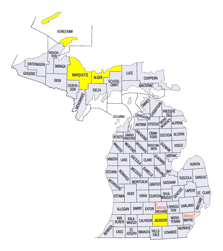
Strong winds were common across the Midwest on November 18-19. A high wind warning was in place across most of Iowa, Wisconsin and Illinois on November 18 as wind gusts of 45-55 mph were common. Several gusts of 60-65 mph were measured near Marquette, MI (Marquette County), while a ship near Isle Royale (Keweenaw County) in Lake Superior recorded a 79 mph wind gust. High waves were also common on Lake Superior, where 24-foot waves were reported near Marquette, MI and Grand Marais, MI (Alger County).
Severe Weather
A line of thunderstorms along the cold front of the storm caused wind damage across northern Indiana and southeastern Michigan on November 18 (Figure 12). Many powerlines and trees were downed from 50-60 mph wind gusts. A 79 mph wind gust was recorded in Jackson, MI (Jackson County) from the line of thunderstorms. One injury was reported in Kosciusko County, IN when a tree fell on a car.
Extreme Temperature Swings
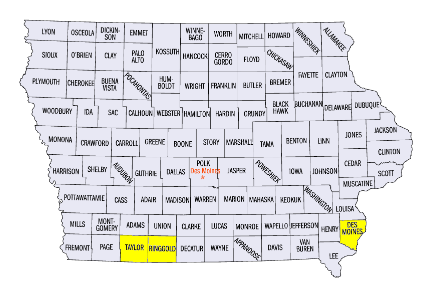
Cold Canadian air surged behind the cold front of the storm and dropped temperatures significantly across the region. Differences from maximum temperatures through the morning of November 18 to minimum temperatures through the morning of November 19 were often 30°F to 45°F colder. A few stations dropped more than 50°F during that period. In Iowa, Burlington (Des Moines County) went from 76°F to 25°F while Bedford (Taylor County) and Beaconsfield (Ringgold County) both went from 74°F to 24°F from November 18 to November 19.
-BJP-