March 15-21, 2016
Midwest Weekly Highlights - March 15-21, 2016
Wet in the Upper Midwest
Wet weather was common across the Upper Midwest as a storm system brought well-above-normal precipitation (Figure 1). The slow-moving system moved through Minnesota, Wisconsin and Michigan on March 15-17 and brought 0.75-1.50 inches of precipitation across these areas (Figure 2). Locally higher amounts in the 2-3 inch range were also observed in Wisconsin, Minnesota and the U.P. of Michigan. Some of this precipitation fell as snow across northern Minnesota and Wisconsin, as well as the western U.P. of Michigan through the morning of February 17 (Figure 3). Between 4-8 inches of snow fell in these areas, with higher amounts in the 8-12 inch range around Lake Superior.
Conditions were drier in the southern half of the region, however. Missouri and Kentucky had less than half the normal amount of precipitation for the period (Figure 4). Most of Illinois, Indiana and western Ohio also had below normal precipitation.
Another Warm Week
Temperatures were above normal once again across most of the region
(Figure 5). Minnesota, Wisconsin, northern Illinois, Indiana and Ohio were mainly 5-7°F above normal for the period. Iowa and Kentucky were 3-6°F above normal, while temperatures were closer to normal across Missouri. The Arrowhead of Minnesota and the U.P. of Michigan were also closer to normal, as snowpack from the morning of March 17 through March 21 kept temperatures lower (Figure 6). The continued warm weather has kept most of the region 5°F or more above normal for the month through March 21
(Figure 7).
March 15 Severe Weather and Tornadoes
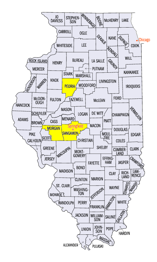
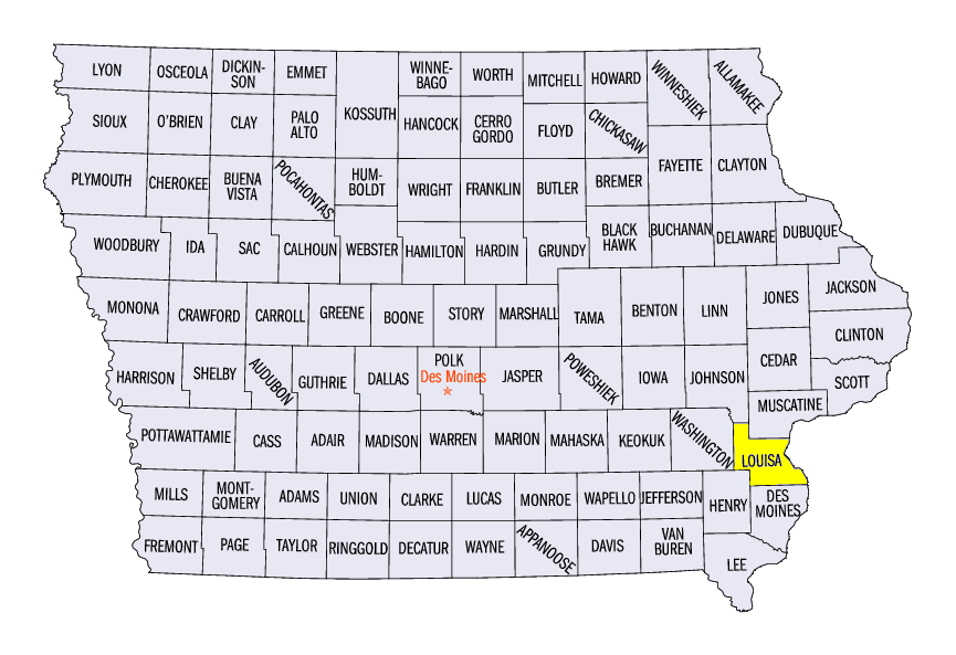
The system that dumped over an inch of precipitation on the Upper Midwest brought severe weather along its cold front on March 15, spawning a few tornadoes in Illinois and eastern Iowa (Figure 8). An EF-1 tornado touched down near Springfield, IL in Sangamon County while an EF-2 tornado was confirmed in Peoria County, IL. A total of eight tornadoes were surveyed. One- to two-inch hail was also reported, with tennis ball-size hail in Louisa County, IA and Morgan County, IL.
March 16 High Winds
High winds were in place on March 16 behind the slow moving system that spawned tornadoes in Illinois and Iowa. Wind gusts in the 40-60 mph range were common across Illinois, eastern Iowa and southern Wisconsin. A 56 mph wind gust was observed at the General Mitchell Airport in Milwaukee, while a 54 mph was recorded at O’Hare Airport in Chicago. Some damage was reported from snapped trees and power poles.
-BJP-