January 8-14, 2016
Midwest Weekly Highlights - January 8-14, 2016
Below Normal Temperatures Finally Settle In
Well-below-normal temperatures finally arrived in the Midwest, as most of the region was near- to below-normal for the period (Figure 1). The Upper Midwest was quite cold, with most of Minnesota and northwest Wisconsin 6-10°F below normal. Parts of Illinois, Kentucky and the U.P. of Michigan were also 1-3°F below normal. Minimum temperatures were further below normal across Illinois, Indiana, Kentucky and Ohio, as single digit lows were common (Figure 2). Most of the region experienced minimum temperatures of 10°F or below from January 11-14. Minimum temperatures reached as low as the -30’s in Minnesota on January 11 (Figure 3), while below zero temperatures reached as far south as Indiana and Ohio through the mornings of January 13-14 (Figure 4) (Figure 5). In most cases, this blast of arctic air produced the coldest temperatures recorded so far during the winter.
However, the cold minimum temperatures across most of the region were slightly offset in some cases. Maximum temperatures were above normal across the southern half of the region, with Ohio 2-5°F above normal for the period (Figure 6). Parts of Lower Michigan had both above-normal maximum and minimum temperatures, leading to average temperatures 2-4°F above normal.
Rainy & Snowy
Precipitation was adequate across most of the region during the period, as several smaller storm systems moved through. Over an inch of precipitation fell along the eastern half of the Ohio River Valley, into northern Indiana and Ohio (Figure 7). Parts of Michigan also had over an inch. Lesser amounts were seen across Missouri, Illinois, Iowa and Wisconsin, while most of Minnesota had less than a tenth of an inch. In most cases, precipitation was near to above normal, with only areas of Minnesota and eastern Kentucky below normal (Figure 8).
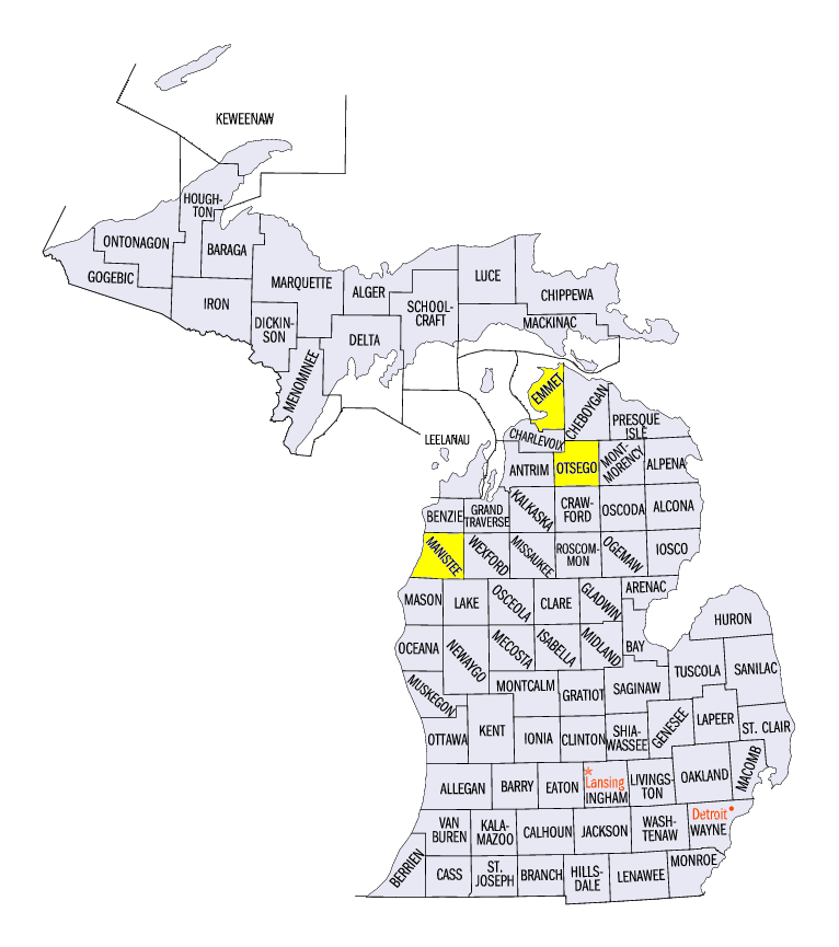
Moderate amounts of snow were also common across the northern half of the region
(Figure 9). Michigan dealt with the heaviest amount of snow due to lake-effect snowstorms that formed and dumped 5-18 inches of snow during the period (Figure 10). Some areas had more than 20 inches of snow, including Wellston in Manistee County (24.4 inches), Petoskey in Emmet County (24.2 inches) and Gaylord in Otsego County (23.8 inches). This was two to three times more than the normal amount of snowfall for the period
(Figure 11). A few inches of snow were also common in parts of Illinois, as a storm tracked across the state through the morning of January 10 (Figure 12). Indiana and Ohio, as well as in parts of Iowa, Minnesota and Wisconsin also saw a few inches of snow from multiple small storms.
Flood Waters Continue to Recede
Flooding on the Mississippi and Illinois Rivers continued to improve during the period, as only a few gauges remained in moderate flood stage by January 14. Flooding continued on the Illinois River from Peoria to the mouth of the river at the Mississippi River near Grafton, IL. Moderate flooding was still occurring at Havana
(Figure 13), Beardstown (Figure 14) and La Grange (Figure 15) as of January 14. On the Mississippi River, all gauges in the Midwest region were below flood stage or were in the process of falling below flood stage as of January 14. River stages were expected to fall throughout the rest of the month of January.
-BJP-