December 2017
Monthly Overview - December 2017
Arctic Air Late in Month
Temperatures were mostly above normal in the first two-thirds of December, especially in the western half of the region. The week leading up to Christmas was particularly warm across the Midwest. Then Arctic air pushed south across the region and extended all the way to the Gulf of Mexico in the last week of the year, bringing the coldest temperatures of the winter season to the entire Midwest. Temperatures for the last seven days of the month were well below normal with departures from normal ranging from 10°F below normal in southeast Kentucky to more than 25°F below normal in northern Minnesota
(Figure 1). More than a thousand record low temperatures were set during the last week of the year. Minimum temperatures for the week averaged below zero for much of the northern half of the Midwest, and dipped to below zero for much of the southern half of the region. In northern Minnesota, temperatures dropped to -40°F. The very cold temperatures late in the month dragged the monthly average temperature below normal for much of the region (Figure 2). Missouri and Iowa, along with parts of western Illinois and southwestern Minnesota, were near-normal for the month while the coolest areas, relative to normal, were along the Great Lakes.
Low Precipitation Totals
Precipitation totals for December were well below normal for the majority of the Midwest
(Figure 3), ranking as the 13th driest December on record (1895-2017). Iowa (5th driest) and Illinois (7th) ranked among the driest Decembers in their records, while Missouri, Indiana, and Ohio ranked in the teens. A swath across northern Missouri and central Illinois received less than 25% of normal for the month. Surrounding areas with less than 50% of normal covered about half the region and extended into every Midwest state except Kentucky. Southern Kentucky was only slightly below normal. The northern areas in Minnesota, Wisconsin, and Michigan were the only in the region to record above normal precipitation. Despite the below-normal precipitation totals (rain plus melted snow), snowfall totals for the month (Figure 4) were above normal near the Great Lakes and across parts of northern Illinois and much of northern and central Indiana and Ohio, as well as northwestern Minnesota.
Lake-Effect Snows
The Great Lakes were nearly ice-free and relatively warm in early December. Colder air flowing over the lakes picked up moisture and heat leading to lake-effect snows on the the downwind side of the lakes. Heavy lake-effect snows began to fall in early December and picked up even more with cold Arctic air masses later in the month. Seasonal snow totals, as the month came to an end, were ahead of normal in the areas downwind of the lakes while much of the remainder of the region was below normal
(Figure 5). The largest deficit from normal stretched from southern Minnesota to southern Wisconsin where seasonal snow totals remained below normal, more than 10 inches below normal in some locations.
Drought
Midwest drought in December was most pronounced in Missouri and neighboring parts of Iowa and Illinois along with a small area of moderate drought in north-central Minnesota (Figure 6). Areas of moderate drought and severe drought expanded slightly in December and the first extreme drought in the region since was introduced into south-central Missouri. The lack of rain and snow in the affected areas is the primary driver of the drought expansion. Although impacts are harder to identify and quantify in the winter, there have been impacts on overwintering crops, low pond levels, and low streamflows
(Figure 7) to also support degradation and expansion. Additionally, areas noted as abnormally dry have also increased, now covering nearly all of the remainder of Missouri, and much of Iowa and southern Illinois.
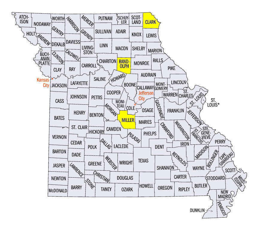
Severe Thunderstorms and Tornadoes in Missouri
December 4th brought severe storms to Missouri and extreme west-central Illinois. Reports of large hail, strong winds, and even a couple tornadoes stretched from southwestern Missouri to west-central Illinois. No injuries were reported with the tornadoes, but there was an injury reported in Randolph County, Missouri due to strong thunderstorm winds. The tornadoes were classified as an EF-1 (Miller County, Missouri) and an EF-2 (Clark County, Missouri).
-MST-
The Iowa Climatology Bureau also contributed to this report.
The Minnesota State Climatology Office also contributed to this report.