October 25-31, 2017
Midwest Weekly Highlights - October 25-31, 2017
Chilly Temperatures
After several warm weeks, the final week of October was much colder than usual across the entire Midwest (Figure 1). Some of the coldest areas were Missouri, Kentucky, Illinois and Indiana, where temperatures were 7-10°F below normal. To the north, Minnesota, Wisconsin and Michigan were 2-6°F below normal. Several hundred daily low temperature records were broken from the cold temperatures (Figure 2). Many of these records were from maximum temperatures through the mornings of October 28 (Figure 3) and October 29 (Figure 4).
Most of the southern and central Midwest received their first fall freeze during the week
(Figure 5). Minimum temperatures in the upper-20s and low-30s were common through the mornings of October 28 (Figure 6) and October 29
(Figure 7), which led to the first freeze. However, many stations in the eastern Midwest did not receive a hard 28°F freeze during the period (Figure 8).
Dry for Many
Very little precipitation fell across Iowa, Missouri, Illinois and southern Wisconsin during the week
(Figure 9). No precipitation fell in most of Missouri and extreme southern Iowa, while Illinois, northern Indiana, southern Wisconsin, northern Iowa and western Minnesota had less than half the normal amount (Figure 10). Wetter conditions were observed in Kentucky, the U.P of Michigan, and the Arrowhead of Minnesota. Western areas of the U.P. of Michigan had more than five times the normal amount. Snowfall from a system was largely the reason for the heavy precipitation in the northern reaches of the region
(Figure 11).
First Snowfall of the Season
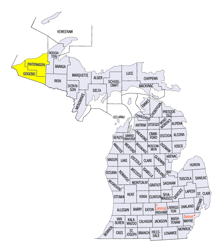
Northern Minnesota and the U.P. of Michigan received the first measurable snowfall in the Midwest that began on October 26 through the morning of October 27 (Figure 12). Northern Minnesota received 4-8 inches of snowfall, while central and southern areas received less than an inch. After the system moved to the east, lake-effect snow began to fall in the U.P. of Michigan off of Lake Superior. In total, areas in the U.P. of Michigan received 4-8 inches of snowfall, with locally heavier amounts over 12 inches
(Figure 13). Some of the heaviest snowfall amounts for the period included 16.5 inches at the Bergland Dam (Ontonagon County), 13.2 inches in Paulding (Ontonagon County) and 13.1 inches in Ironwood (Gogebic County). More than 50 daily snowfall records were broken during the week, with most in Minnesota (Figure 14).
Drought Slightly Improves, Except in Missouri
Slight improvements in drought were noticed in Illinois, Indiana and Ohio according to the October 31 U.S. Drought Monitor (Figure 15). Drought was removed from most of central Illinois, and contracted in northeastern Ohio and west-central Indiana. However, moderate drought expanded in southwestern Illinois and east-central Missouri. Areas where moderate drought were introduced included the city of St. Louis. An estimated six million people were living in drought affected areas.
-BJP-