October 18-24, 2017
Midwest Weekly Highlights - October 18-24, 2017
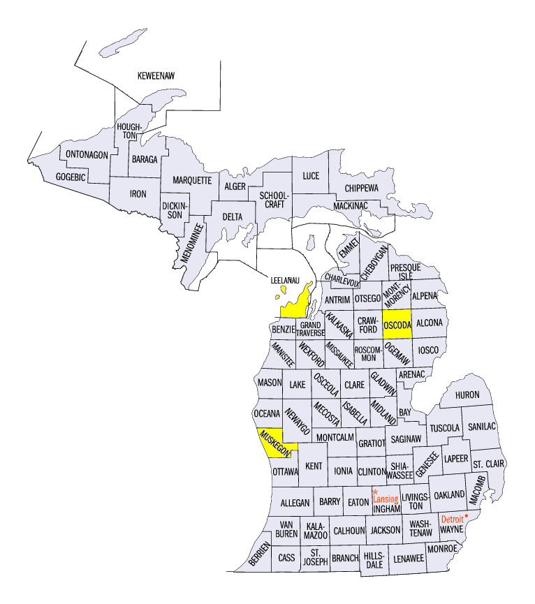
Heavy Rain in Michigan
A slow-moving system dumped heavy rain across portions of the Midwest, with the heaviest rainfall in northern Lower Michigan (Figure 1). The system moved into the Midwest on October 21, before slowly moving eastward. On October 23 through the morning of October 24, 3-5 inches of rain fell in northern Lower Michigan (Figure 2). Some of the heaviest totals for the October 23-25 period included 5.21 inches in Mio (Oscoda County), 5.08 inches in Maple City (Leelanau County) and 5.01 inches in Muskegon (Muskegon County). In most cases, the rainfall in northern Lower Michigan was 3-5 times the normal amount (Figure 3). More than 100 daily precipitation records were broken across the Midwest, with nearly half occurring in Michigan (Figure 4).
Elsewhere, western Missouri, eastern Illinois, northwestern Indiana and eastern Kentucky were also wet. An inch and a half of rainfall fell in these areas. Drier conditions were found across northern and western Minnesota, where less than half the normal amount fell.
Warm Weather Continues
Above-normal temperatures were widespread across the Midwest once again
(Figure 5). Only a few areas along the border of Missouri and Kentucky were near normal. Northern Minnesota, northern Wisconsin, and the U.P. and northern Lower Michigan were 9-12°F above normal for the period. Iowa, northern Illinois, Indiana and Ohio were 5-8°F above normal. More than 100 daily high maximum and minimum temperature records were tied or broken during the period (Figure 6).
Drought Expands in Missouri
Moderate drought expanded across southeastern Missouri according to the October 24 U.S. Drought Monitor
(Figure 7). Coverage of drought across the state increased from 25 to 32 percent from the week prior. Meanwhile, abnormally dry conditions decreased across the state as a whole. In Iowa, severe drought was eliminated while moderate drought also decreased to less than six percent of the state. Abnormally dry areas significantly decreased in Michigan as well, as heavy rain fell during the period. Overall, five million people were estimated to be living in drought affected areas across the Midwest.
Corn Harvest Remains Behind Schedule
Late planting of corn coupled with wetter weather left most of the Midwest behind schedule with the corn harvest (Figure 8). Wisconsin, Iowa and Minnesota were all 20 or more percent behind the five-year average harvest for the week ending October 22. Minnesota was a full 40 percent behind. Missouri, Illinois, Indiana and Ohio were all more than ten percent behind schedule. The soybean harvest made progress, however (Figure 9). Farmers in Iowa and Minnesota were able to harvest during the week, lowering the percent behind the five-year average to 20 percent and 10 percent, respectively. Just one week earlier, Iowa was 34 percent behind while Minnesota was 37 percent behind (Figure 10).
-BJP-