January 22-31, 2017
Midwest Weekly Highlights - January 22-31, 2017
Warm Weather Continues
Above-normal temperatures continued across the entire Midwest during the week
(Figure 1). Almost all of the region was at least 6°F above normal, with the upper Midwest more than 8°F above normal. Minnesota and northern Wisconsin were 12°F or more above normal, with areas in northwestern Minnesota as much as 18°F above normal. Minimum temperatures played a large part, as most of the region had average minimum temperatures 10°F or more above normal (Figure 2). Most of Minnesota was 20-25°F above normal. More than 300 daily high minimum temperature records were broken during the period, including nearly 200 in Wisconsin and Minnesota alone. Many of these occurred on the mornings of January 23
(Figure 3) and January 24 (Figure 4). Minimum temperatures stayed above freezing on both days across most of the region.
Dry South, Snowy North
Very little or no precipitation fell across the southern half of the Midwest during the week
(Figure 5). Most of Illinois, Indiana and eastern Kentucky had less than half the normal amount for the period (Figure 6). Further north, a snowstorm on January 24-26 brought over half-an-inch of precipitation to northern Iowa, southern Wisconsin and Lower Michigan. In many cases, this was more than twice the normal amount. Snowfall during the period was largely limited to the upper Midwest, with amounts of less than an inch in Indiana, Ohio and eastern Kentucky
(Figure 7).
January 24-26 Snowstorm
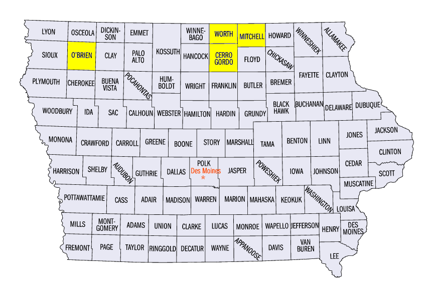
A storm brought heavy snow from January 24 through the morning of January 26 from northern Iowa through Lower Michigan. The snow began on January 24 through the morning of January 25 in western Iowa, where 8-12 inches of snow fell (Figure 8). Some of the heavier totals included 12.6 inches in Sanborn (O’Brien County), 12.0 inches near Mason City (Cerro Gordo County) and 11.2 inches in Northwood (Worth County) and St. Ansgar (Mitchell County). Amounts of 3-6 inches were also reported in southwestern Wisconsin. Snowfall continued during the day on January 25 through the morning of January 26 in Iowa, southern Wisconsin and Lower Michigan
(Figure 9). The heaviest totals were in eastern Wisconsin and northern Lower Michigan, where 3-5 inches fell. The snowfall from this storm was the first major snowfall in Iowa and southern Wisconsin in January, as only 1-2 inches of snow had fallen through the morning of January 24 (Figure 10).
Drought Coverage in Missouri Decreases
Drought coverage in Missouri decreased from 40 percent of the state to 8.5 percent in the January 31 U.S. Drought Monitor
(Figure 11). While precipitation in the state has been below normal in recent months, demand is low and the rain that fell has been absorbed into the system. Streams and rivers continued to flow at a normal rate and soil moisture conditions were adequate. Abnormally dry conditions remain, however - almost 90 percent of the state was rated abnormally dry. Abnormal dryness in the Midwest as a whole decreased by nearly half in January from 27 percent to 15 percent.
-BJP-