January 1-7, 2017
Midwest Weekly Highlights - January 1-7, 2017
Cold Weather Returns
Cold weather returned to the Midwest after a warm last week of 2016
(Figure 1). Only parts of eastern Kentucky and Ohio were near normal, while the rest of the region was below normal for the week. Most of Illinois, Missouri, Wisconsin and Minnesota were 5°F or more below normal, with western Minnesota 8-11°F below normal. More than two dozen daily record low maximum temperatures were recorded from January 5-7. Many of these records were in the eastern half of the region, where maximum temperatures were in the low to mid-teens across Indiana, Ohio and Michigan on January 6 (Figure 2). Minimum temperatures averaged in the single digits above zero to as much as 15°F below zero in the Upper Midwest
(Figure 3). Minimum temperatures through the morning of January 7 reached the -20s and -30s across northern Minnesota (Figure 4). One of the coldest locations was Cotton, MN (St. Louis County) at -38°F.
Snowy and Wet
Northwestern Minnesota, southern Michigan, northern Indiana, Ohio and eastern Kentucky received ample precipitation during the period
(Figure 5). Parts of northwestern Minnesota had more than twice the normal amount, while Ohio had one-and-a-half times the normal amount (Figure 6). Snowfall was common across most of the region
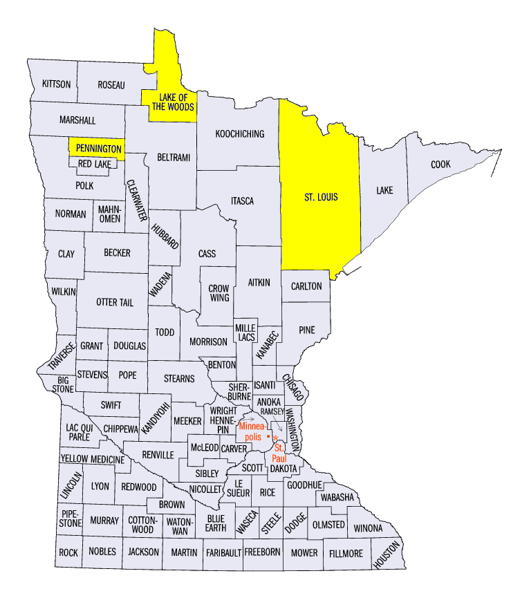
(Figure 7). Northwestern Minnesota received up to 10 inches of snowfall from a storm on January 1-3. A majority of the snowfall fell through the morning of January 3 (Figure 8). Totals for that day included 10.0 inches at Camp Norris (Lake of the Woods County), 9.2 inches at Kabetogama (St. Louis County) and 8.0 inches near Thief River Falls (Pennington County). Lake-effect snowfall was also common across western Lower Michigan and the eastern U.P. of Michigan throughout the period. The southern third of the region also received an inch or more of snowfall in areas, which was more than twice the normal amount in eastern Kentucky and western Missouri
(Figure 9).
Drought Expanding in Missouri
Abnormally dry conditions deteriorated into moderate drought across portions of Missouri in the January 3 U.S. Drought Monitor (Figure 10). Pockets of drought were added to central, southern and eastern Missouri and parts of western Illinois largely due to precipitation departures of 4-8 inches below normal during the last three months of 2016 (Figure 11). More than a quarter of Missouri was classified in drought, and over one million people were estimated to be living in drought-affected areas in the region.
-BJP-