November 22-30, 2018
Midwest Weekly Highlights - November 22-30, 2018
Continued Cold
Temperatures remained cold across the Midwest during the period
(Figure 1). Only a few areas in northern Minnesota and Wisconsin were near normal. Some of the coldest areas were in southern Iowa, northern Missouri, Ohio and Kentucky, where temperatures were 4-7°F below normal. Maximum temperatures were even colder in these areas, with eastern Kentucky and Ohio 6-9°F below normal (Figure 2). More than 200 daily low maximum and minimum temperature records were broken during the period
(Figure 3).
Mainly Dry, But Snowy
With colder temperatures across the region, snow was more common than rain. Liquid-equivalent precipitation was heaviest across northern Illinois, northern Indiana, northwestern Ohio and eastern Kentucky, where more than an inch fell (Figure 4). This was only significantly above normal in northern Inllinois and Indiana, however
(Figure 5). Snowfall amounts were heavy across these areas, with many receiving more than five inches of snow from northwestern Missouri through southern Lower Michigan (Figure 6). Lake-effect snow in the U.P. of Michigan also amounted to more than five inches. More than 100 daily snowfall records were broken during the period
(Figure 7). Meanwhile, a large portion of the Upper Midwest, southern Missouri and the Ohio River Valley were much drier than normal. Less than a quarter of the normal amount fell across western Minnesota and southwestern Wisconsin. However, the Midwest remained drought free in the November 29 U.S. Drought Monitor (Figure 8). Only a few areas of western Missouri and northern Minnesota were considered abnormally dry.
November 25-26 Blizzard
A potent winter storm coupled with cold temperatures led to an intense blizzard across northern Missouri, southern Iowa and northern Illinois on November 25-26 (Figure 9). The storm moved into the Great Plains on November 24, before strengthening during the overnight hours into November 25. Heavy snow began to fall in southern Iowa and northern Illinois during the morning of November 25, with strong winds of 30-40 mph. Bands of snow dumped more than an inch in an hour at times. During the afternoon, the heaviest snowfall moved into northern Illinois, while lighter snow remained in southern Iowa and northern Missouri. Snow continued into the overnight hours in southeastern Iowa and northern Illinois before beginning to lose strength over Lower Michigan during the day of November 26 (Figure 10).
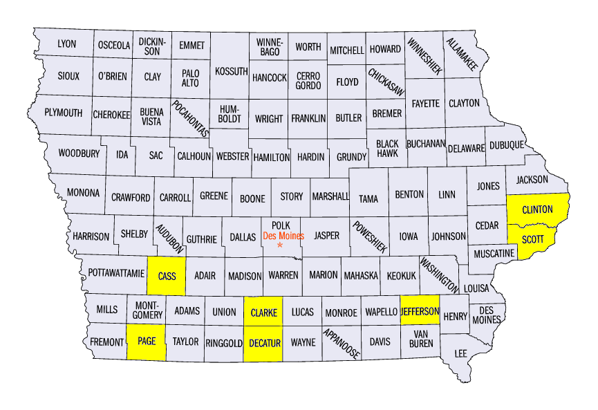
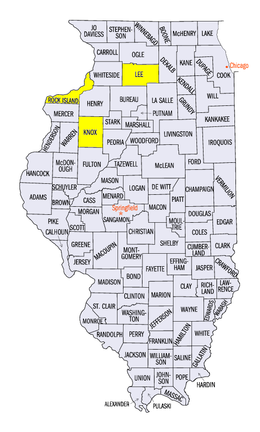
Snowfall totals were highly variable due to the limited extent of the heaviest snowfall bands. Clinton, IA (Clinton County) received 12.1 inches from November 25-26, while the Dubuque Regional Airport (Dubuque County), 50 miles to the northwest, only received a trace. Other heavy snowfall amounts in Iowa included 13.0 inches in Osceola (Clarke County), 12.0 inches at the Davenport NWS Office (Scott County), and 11.0 inches in Fairfield (Jefferson County). In Illinois, amounts included 13.8 inches at the Moline Quad Cities Airport (Rock Island County), 13.5 inches in Altona (Knox County) and 13.0 inches in Amboy (Lee County). Amounts of 6-8 inches were also recorded in northwestern Missouri.
Winds were a major component to creating hazardous conditions that led to blizzard warnings in southern Iowa and northern Illinois
(Figure 11). Several reported wind gusts in Iowa included 47 mph in Lamoni (Decatur County), 44 mph at Clarinda (Page County) and 43 mph at Atlantic (Cass County). Sustained wind speeds in Iowa and Illinois also were in the 30-40 mph range.
-BJP-