March 1-10, 2019
Midwest Weekly Highlights - March 1-10, 2019
March Starts Cold
Temperatures were below normal across the Midwest during the first week of meteorological spring (Figure 1). Most of the western Midwest was 10°F or more below normal while Indiana, Kentucky, Ohio and Lower Michigan were 6-10°F below normal. Parts of western Iowa, southern Minnesota and northwestern Wisconsin were more than 15°F below normal for the period. This cold was most prominent in maximum temperatures (Figure 2).
More than 750 daily low maximum temperature records were broken or tied during the period
(Figure 3). More than 600 of these records occurred through the mornings of March 4 (Figure 4) and March 5
(Figure 5). Maximum temperatures struggled to reach double digits above zero, with parts of Minnesota below zero through the morning of March 4. While temperatures began to warm, more records fell during another cold day through the morning of March 6 (Figure 6). Combined with minimum temperatures, more than 1,000 daily low records were tied or broken during the period.
Ample Precipitation
Most of the Midwest received moderate precipitation amounts during the week (Figure 7). Most of the region was near to above normal, with only a few areas of Michigan and the Arrowhead of Minnesota significantly below normal (Figure 8). The wettest day during the period was through the morning of March 10 (Figure 9). Most of the more than 150 daily precipitation records during the period occurred on that day (Figure 10).
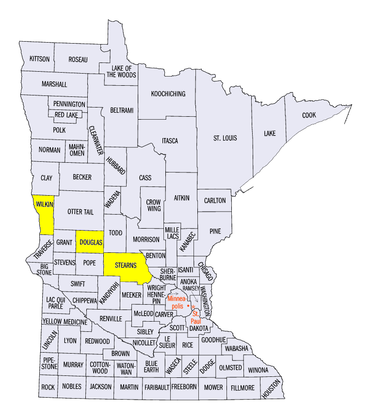
Cold temperatures led to moderate amounts of snowfall across the central part of the region, with heavy snowfall in Minnesota, northern Wisconsin and parts of Michigan
(Figure 11). Most of the heavy snowfall in the Upper Midwest fell through the morning of March 10 (Figure 12). Some of the heaviest amounts in western Minnesota included 16.8 inches near Carlos (Douglas County), 16.0 inches in Collegeville (Stearns County) and 15.4 inches near Breckenridge (Wilkin County). More than 100 daily snowfall records were broken during the period
(Figure 13).
Lack of Dryness Continues
For the second consecutive week, the Midwest remained free of abnormally dry and drought conditions in the March 5 U.S. Drought Monitor (Figure 14). This was only the fourth week since the beginning of the U.S. Drought Monitor in January 2000 that the region was free of abnormally dry conditions and drought and the first time in consecutive weeks. The lack of dryness wasn’t limited to just the Midwest, however, as most of the eastern half of the U.S. was free of drought and abnormally dry conditions
(Figure 15). Soil moisture was very high across the eastern U.S (Figure 16).
-BJP-