March 2020
Monthly Overview - March 2020
Plentiful Precipitation
Wet weather was widespread across the Midwest in March
(Figure 1). Precipitation for the region was 3.68 inches which was 1.16 inches above normal. This ranked among the 15 wettest months of March on record (1895-2020). Heavy rain impacted the Ohio River Valley, southern Missouri throughout the period. Snowfall and rain also impacted northeastern Wisconsin and the eastern U.P. of Michigan, where more than twice the normal amount of precipitation fell (Figure 2). More than 500 daily precipitation records were broken across the region in March
(Figure 3), with several rural stations recording monthly records.
Warm Weather Throughout
Temperatures were warmer than normal across almost the entire Midwest in March (Figure 4) . Average temperature for the region was 40.6°F which was 3.8°F above normal. This ranked among the 15 warmest months of March on record. Areas of Kentucky and Ohio were as much 6°F above normal while most of the region was 2-4°F above normal. The only area that was near normal was northwestern Minnesota. Closer to normal temperatures in mid-March
(Figure 5) were bookended by extreme warmth over the first (Figure 6) and last weeks of the month
(Figure 7). In total, more than 200 daily high maximum and minimum temperatures were broken across the Midwest (Figure 8).
Limited Snowfall
Warmer temperatures limited snowfall across the Midwest
(Figure 9). Northern Minnesota and the U.P. of Michigan were the only areas where more than five inches of snow fell in March. Some portions of western Iowa and northern Illinois had 2-4 inches. Most of the Midwest had less than half the normal snowfall for March (Figure 10), with only northern Minnesota and northern Illinois receiving more than the normal amount.
Severe Weather
Severe weather was limited to the final two weeks of March
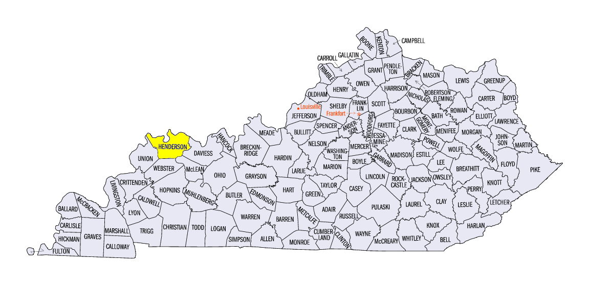
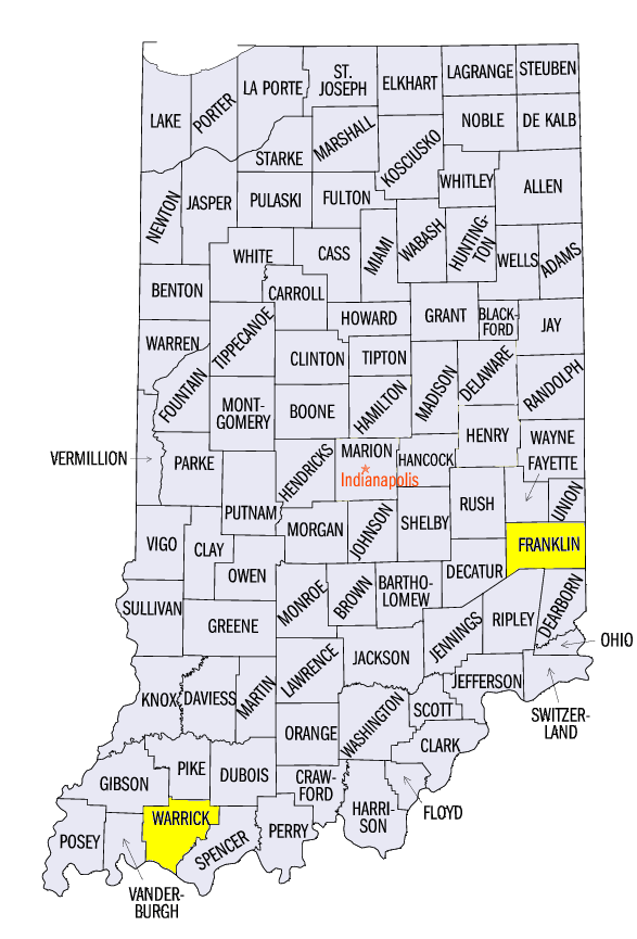
(Figure 11). More than 350 reports of wind, hail and tornadoes were reported. Most of these reports occurred on March 28, when a system brought strong storms to the southern half of the Midwest. Tornadoes were observed in Iowa, Wisconsin, Illinois and southern Indiana, with reports of large hail and damaging winds across the region. An EF-2 tornado was surveyed near Corydon, KY (Henderson County) while several other EF-1 tornadoes were reported. Two injuries were reported from a tornado in Newburgh, IN (Warrick County). Numerous farm outbuildings and trees were damaged.
Flooding
Heavy rain in the Ohio River Valley and along the Mississippi River led to minor and moderate flooding during the second half of March (Figure 12). Significant impacts were felt in southern Indiana and northwestern Kentucky from heavy rain on March 19-20. Several bridges were washed out. A bridge in Laurel, IN (Franklin County) washed out with two vehicles on the morning of March 20, which resulted in six fatalities, including three children. Minor and moderate flooding continued through the end of March as rainfall continued to fall and soils remained near saturation across the Midwest.
Lack of Drought Remains
For the 21st consecutive week, the Midwest remained free of drought in the March 31 U.S. Drought Monitor
(Figure 13). This streak is the second longest on record to the January 1-August 6, 2019 streak of 32 weeks. Since January 1, 2019, 53 of 66 weeks have been drought free. Abnormally dry conditions have also not been observed in the Midwest since the week of January 7, 2020, which was a stretch of 12 consecutive weeks. Very high soil moisture values were observed across the Midwest in March (Figure 14). Warmer conditions also thawed soils, which allowed rainfall to further elevate the water table. Concern of a repeat of 2019 with agricultural delays and flooding was widespread across the region.
-BJP-