May 2007
Midwest Monthly Highlight - May 2007
Moderately Warmer Than Normal Around the Region......
Average daily temperatures were above normal for almost all of the Midwest this past May, with the only exception being the extreme northwest corner of Minnesota where temperatures were barely below the average (Figure 1). The largest departures from normal formed a bulls eye over Illinois where the average daily temperatures ranged from 4.5°F to 6°F+. Central Illinois, Indiana, Ohio and sections of Kentucky had scorching average daily maximum temperatures that ranged from 4°F to 6°F above normal (Figure 2), while the average minimum temperatures were slightly lower for those areas. Missouri and Iowa received the warmest overnight temperatures that ranged from 4°F to well over 6°F above normal (Figure 3).
Precipitation fell in copious amounts throughout May along the western portions of Minnesota, Iowa and Missouri. The heaviest occurred during the first week in Southwestern Iowa and North central Missouri. Records occurred at many river gauge locations, almost beating the floods of 1993. As the month progressed Ohio, Indiana, Kentucky and parts of Illinois fell below the monthly mean (Figure 4). A few record low rainfalls for the month of May occurred in Ohio. Cleveland, OH received 0.66" this May, second only to 1934 during the Dust Bowl years. Normally Cleveland should see 3.50" of precipitation. Other dry Ohio locations include Waverly: 0.59", Sciotoville: 0.57", Washington: 0.70" and West Union: 0.29" (Figure 5).
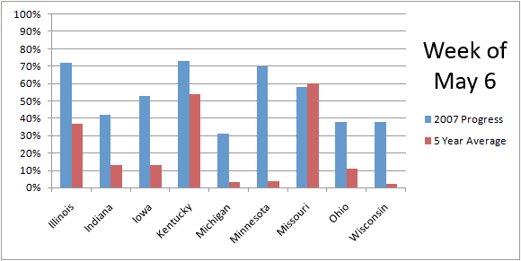
Agriculture
2007 Corn Planting Progress (%) |
||||
6-May |
13-May |
20-May |
27-May |
|
| Illinois | 72 |
93 |
98 |
100 |
| Indiana | 42 |
78 |
94 |
98 |
| Iowa | 53 |
77 |
93 |
98 |
| Kentucky | 73 |
78 |
83 |
89 |
| Michigan | 31 |
60 |
80 |
93 |
| Minnesota | 70 |
88 |
98 |
99 |
| Missouri | 58 |
65 |
87 |
93 |
| Ohio | 38 |
88 |
96 |
100 |
| Wisconsin | 38 |
76 |
89 |
95 |
SSS