September 2026
September 2026 Overview – Midwestern Regional Climate Center
Temperature
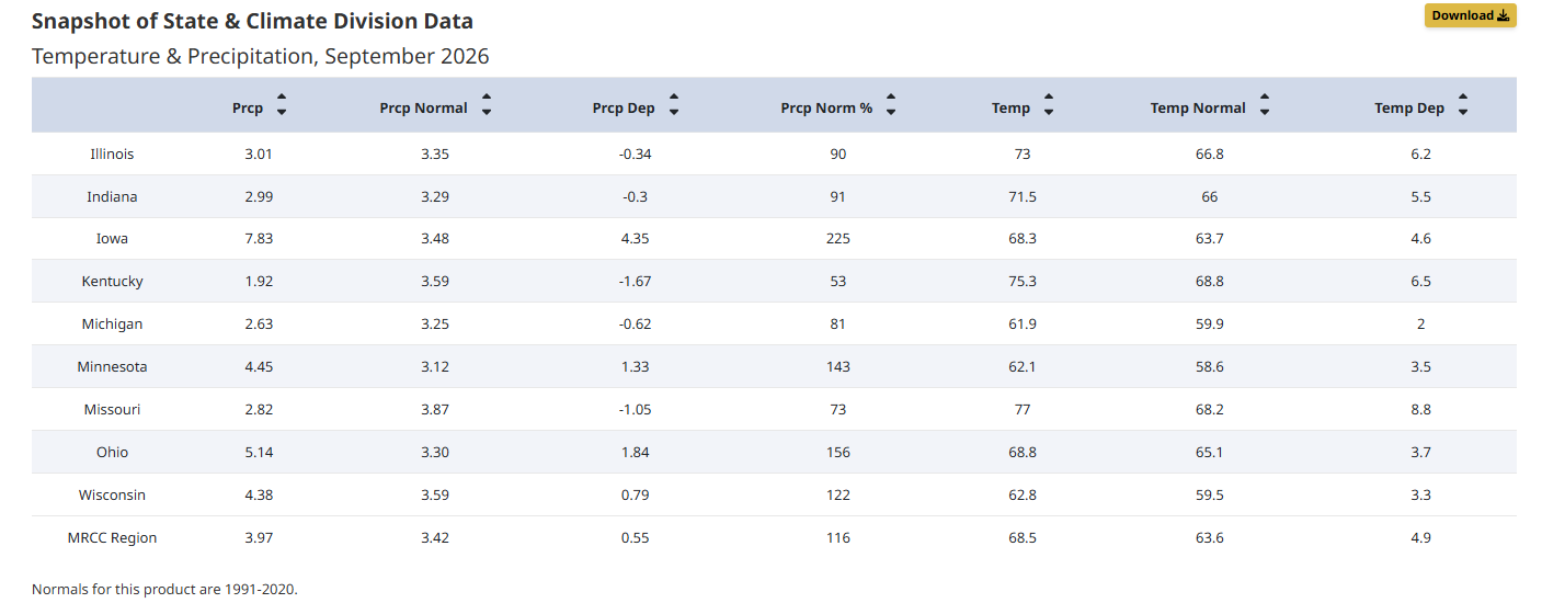
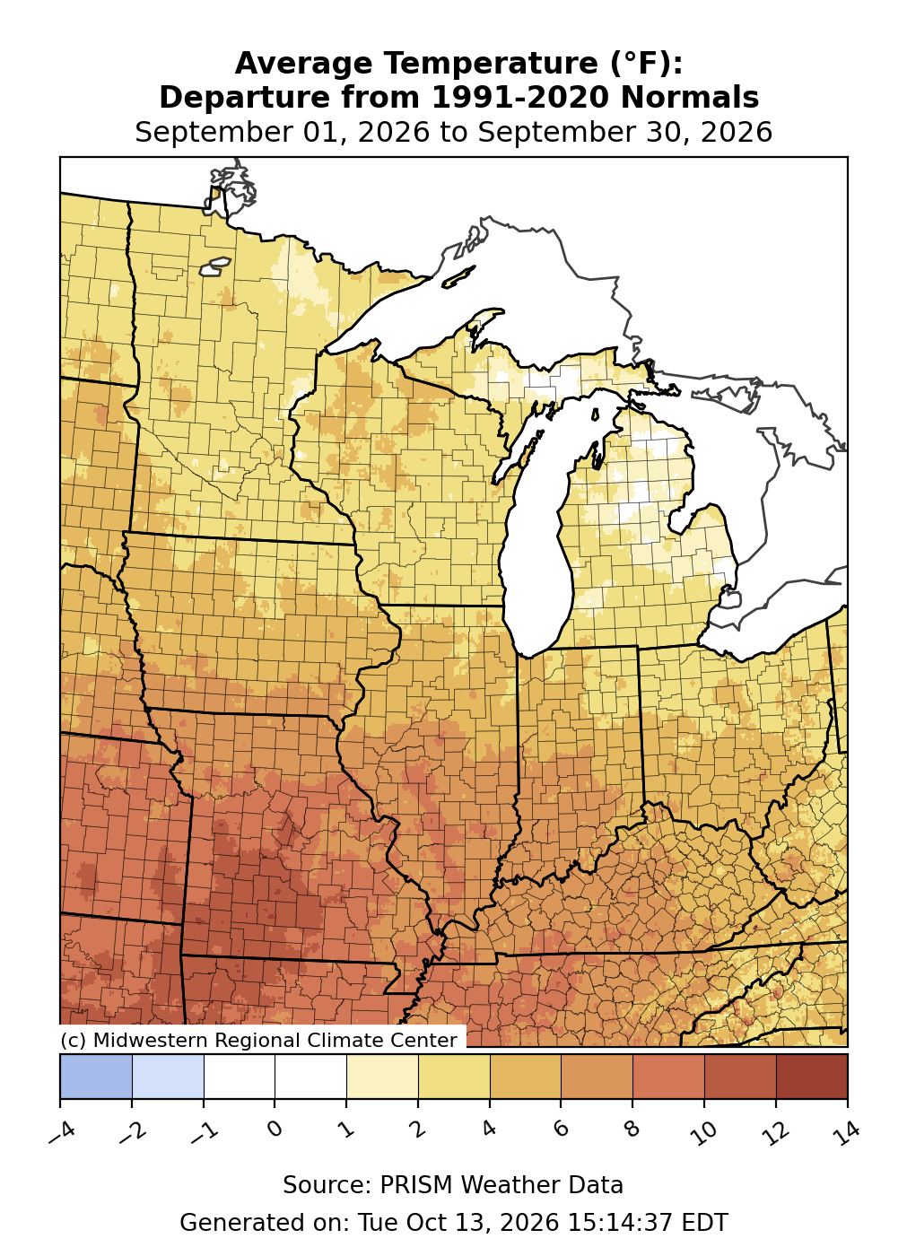
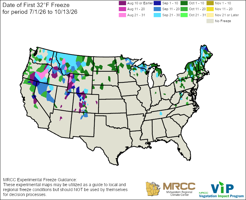
The average September temperature for the Midwest was 68.5°F, 4.9°F above the 1991-2020 normal (Figure 1). The entire region had above-normal temperatures, with conditions 1-4°F above normal across the upper Midwest and 6 to 12°F above normal across the lower Midwest (Figure 2). Final rankings indicate the Midwest had its 2nd warmest September on record. Statewide average temperatures ranged from 2.0°F above normal in Michigan to 8.8°F above normal in Missouri. Final rankings indicate that Missouri and Illinois had their warmest September on record. Four other states had near-record warm September temperatures, including Indiana (2nd), Kentucky (2nd), Iowa (5th), and Ohio (9th). September started with unseasonal warmth regionwide, accompanied by record warmth across the southern half of the region (see Early September Heatwave section below). Above-normal temperatures moderated in the north by mid-month, while the warmth persisted across the south. Areas across Michigan’s Upper Peninsula and extreme northern Minnesota and Wisconsin had their first freezing temperatures of the fall season during the second half of September (Figure 3). It was not until the last week of September that temperatures in the central and eastern Midwest returned to normal or slightly below normal, but across Missouri, above-normal warmth lingered. In Missouri, Columbia, Springfield, and St. Louis had their warmest September on record, with observations dating back 138 to 152 years. Other long-running weather stations across the lower Midwest that had record warmth included: Indianapolis (IN), Joplin (MO), Pana (IL), Rockville (IN), Scottsville (KY), Urbana (IL), and Washington (IN). Joplin, Missouri, which typically averages about one September day per year with maximum temperatures at or above 95°F, had a record-shattering 16 days this year. St. Louis logged its greatest number of September days with a heat index at or above 100°F, with 9 days, breaking the previous record of 6 days set in 1895.
Precipitation
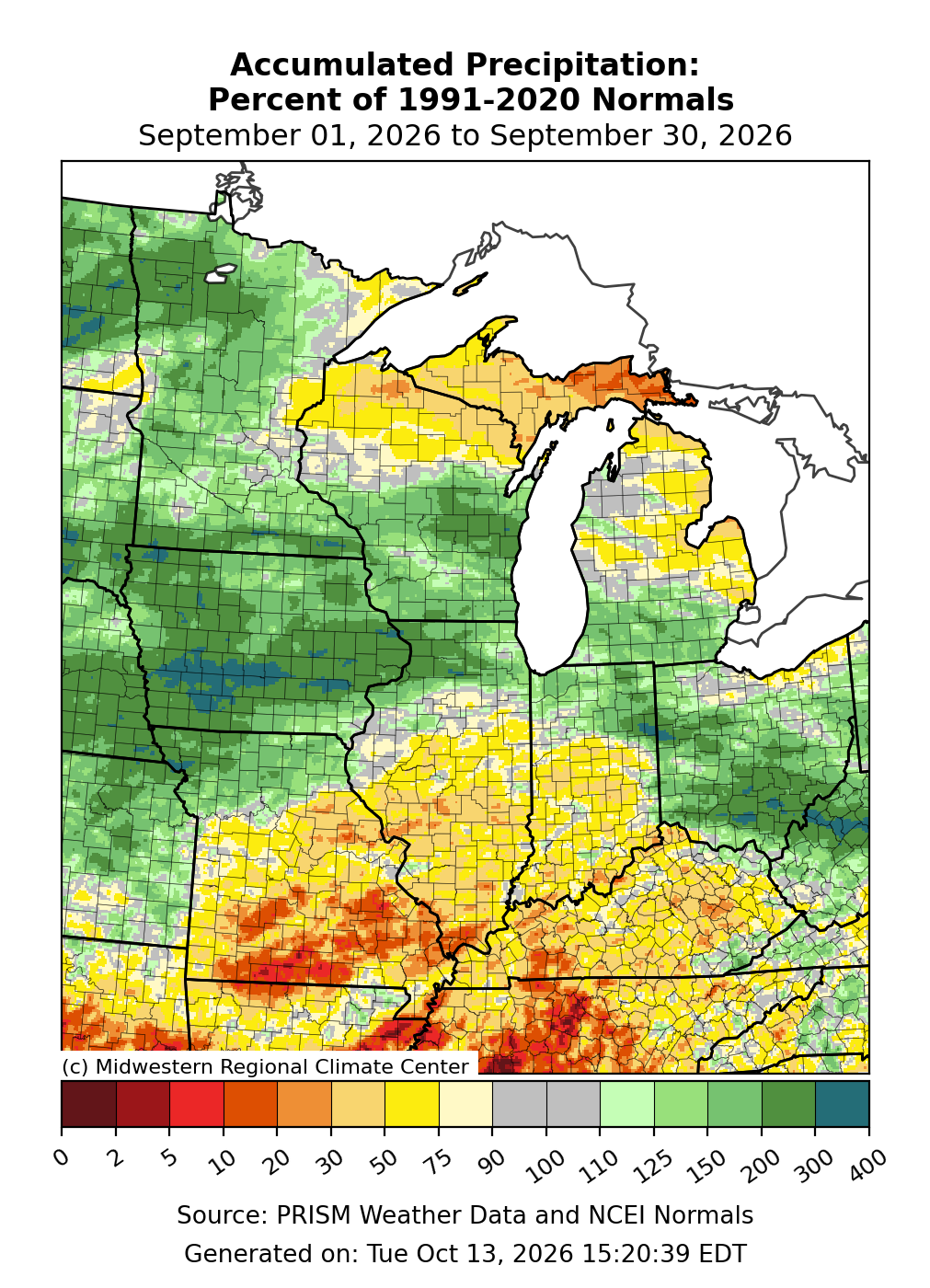
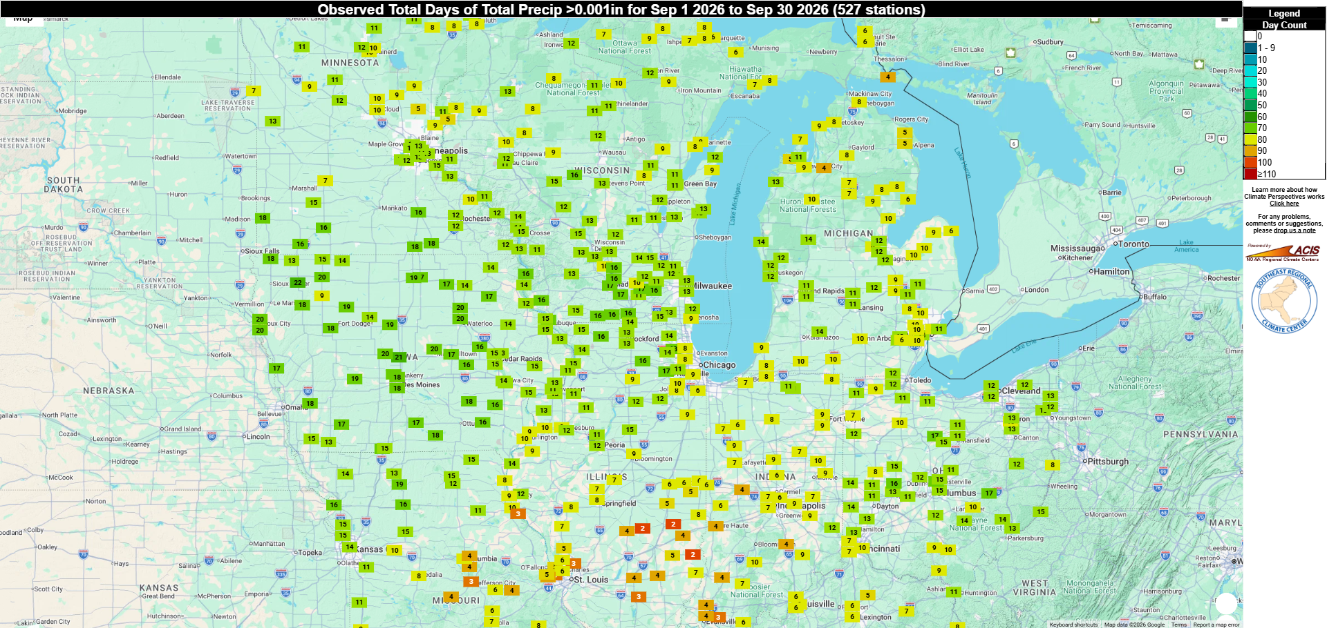
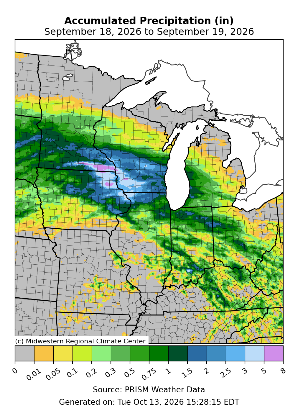
September precipitation totaled 3.97 inches for the Midwest, which was 0.55 inches above normal, or about 116 percent of normal (Figure 1). A persistent storm track brought abundant precipitation, with monthly totals that were 150-400 percent of normal, across a swath encompassing an arc from Iowa to lower Lake Michigan to Ohio (Figure 4). Conversely, the lower Midwest and areas along the southern shore of Lake Superior had precipitation that was 5-50 percent of normal for the month. Statewide precipitation totals ranged from 1.67 inches below normal in Kentucky to 4.35 inches above normal in Iowa. Final rankings indicate that Iowa had its 4th wettest September on record, and Ohio and Minnesota had their 8th and 16th wettest, respectively. In the wettest areas across the region, the persistence of wetness was notable, with measurable rainfall occurring on about 12 to 20 days of the month (Figure 5). Des Moines, Iowa, had its 2nd wettest September since 1878, with 14.5 inches, and a record-setting 5 days with rainfall totals exceeding 1 inch. Mid-month, a potent weather system brought several days of widespread rainfall across the region's north-central corridor. During this event, southeast Minnesota was particularly hard-hit on September 18-19 with a deluge that brought rainfall totals of 5 to 8 inches (Figure 6). In Houston and Spring Valley, precipitation measurements exceeded 8 inches in just 24 hours, which qualified as a 100-year event for this part of the state. According to the Minnesota State Climatology Office, the intense rainfall caused widespread flooding, triggering mudslides and forcing road closures and evacuations. Conversely, a broad area across southern Missouri collected less than 0.5 inches for the entire month. Tecumseh (south-central Missouri) measured 0 inches of rainfall in September for only the second time in nearly 80 years of record-keeping. In Michigan’s Upper Peninsula, the Sault Ste. Marie area had its 2nd driest September since 1888 with just 0.79 inches of rainfall for the month. Along the Wisconsin-Michigan border, Iron Mountain had its 6th driest September since 1893, with just 1.04 inches of precipitation.
Drought
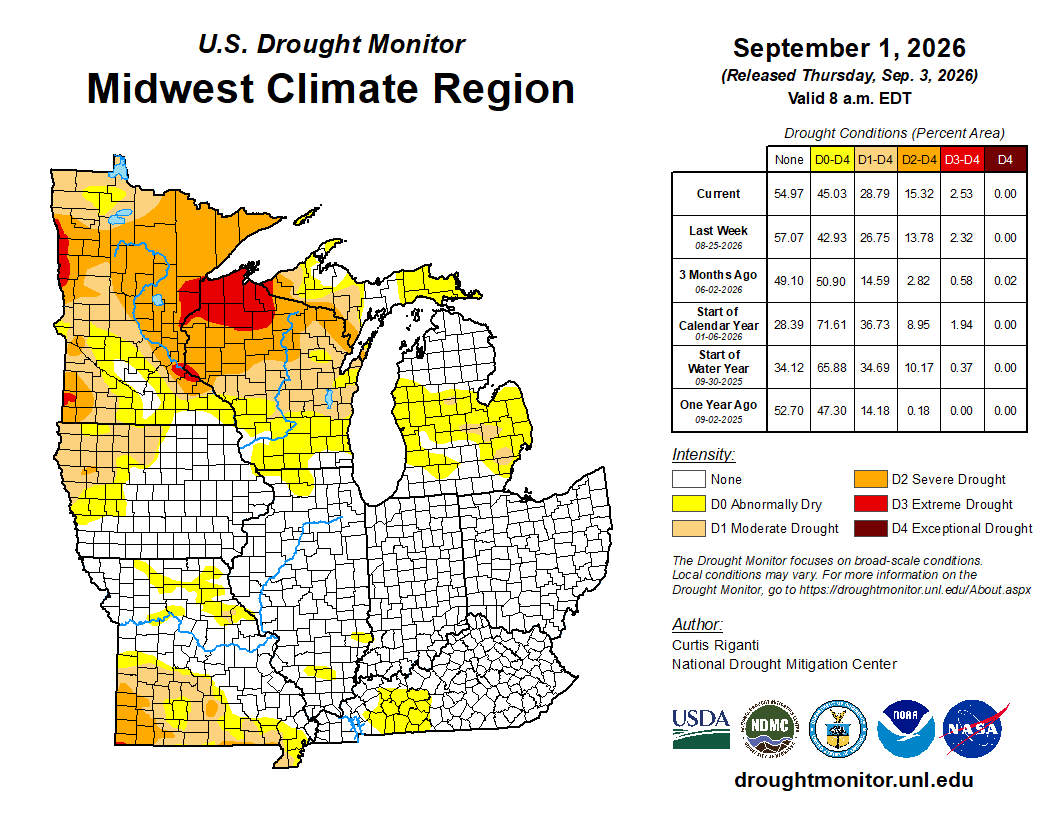
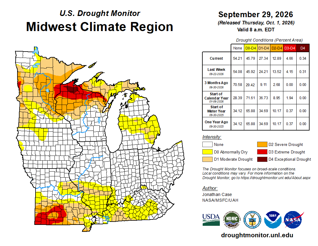
September started (Figure 7) and ended (Figure 8) with about 45 percent of the Midwest designated as abnormally dry or in drought, according to the U.S. Drought Monitor (USDM) map. While the total affected area was unchanged in September, drought intensified across the far southern and far northern stretches of the region, while the central region remained unaffected by drought or dryness. In Wisconsin, ample precipitation resolved drought conditions in the south, but extreme (D3) drought expanded in the north and exceptional (D4) drought was introduced across several counties for only the second time since the inception of the USDM. Across drought-affected areas in the upper Midwest, river and stream levels are very low, rangelands are in poor condition, farmers are hauling water and providing supplemental feed for livestock, wildland fire risk is above normal, and some communities are asking residents to conserve municipal water. Southern Missouri had a wide expansion of D3 drought in September. Across southern Missouri, there are reports of below-normal streamflow, crop yield losses, livestock stress and deaths, and an early start to the fire season. Iowa, on the other hand, was completely drought-free by late September, with just a few counties still denoted as abnormally dry.
Early September Heatwave
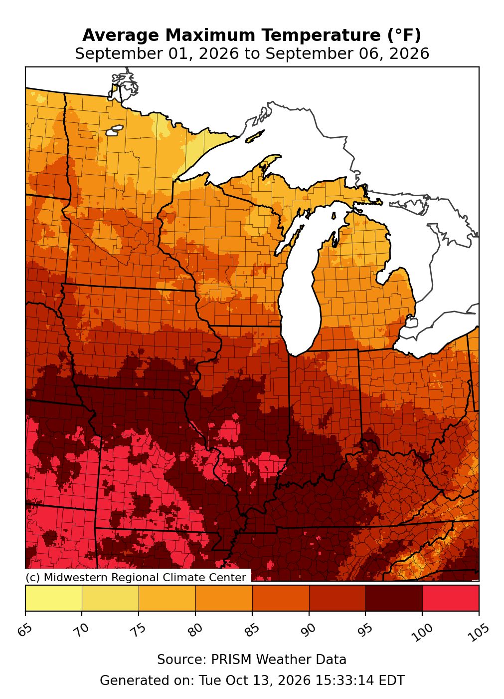
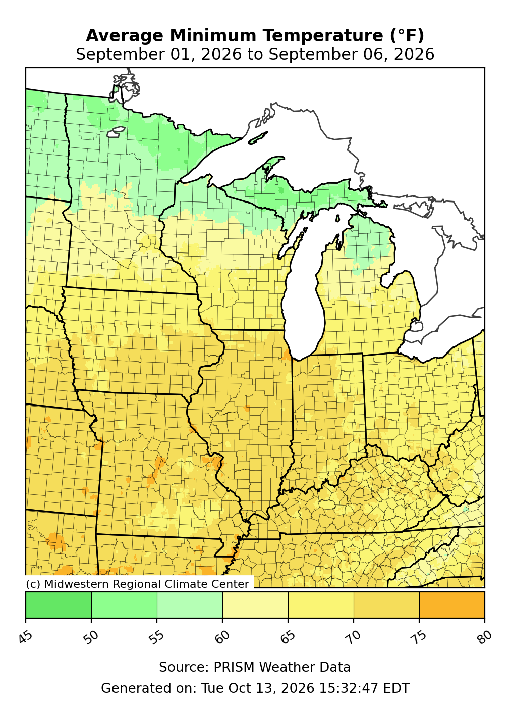
An intense heatwave blanketed the lower half of the Midwest during the first week of September, breaking long-standing air temperature and heat index records. Daytime high temperatures from September 1-6 averaged between 90 to 105°F, accompanied by dew point temperatures in the 70s, which created dangerous outdoor conditions (Figure 9). Additionally, overnight temperatures remained above 70°F throughout the heatwave, offering little to no relief and increasing the risk of heat stress in humans and animals (Figure 10). In Springfield, Missouri, maximum temperatures at or above 98°F were observed for 6 consecutive days, September 1-6, which is the longest stretch of such heat in September since records began in 1888. Several climate stations achieved their all-time record high heat index for September, including Paducah (110°F), Evansville (108°F), Cape Girardeau (108°F), and Carbondale (106°F—Tied). The record-warm start to the month led schools and sporting events to modify or cancel outdoor activities throughout Illinois, Indiana, and Iowa. Tragically, a college marching band student died after collapsing from the heat on September 5 in Iowa City, Iowa.