September 22-30, 2026
Temperature
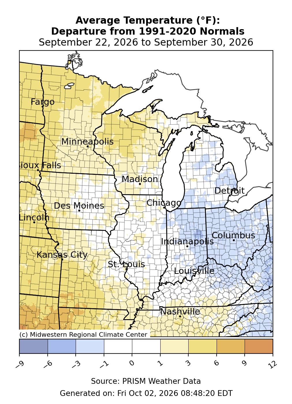
Average temperature departures followed an east-west pattern (Figure 1). Across northern Wisconsin, Minnesota, and western Missouri, temperatures averaged up to 6°F above normal. Many places along and west of the Mississippi River were 1-3°F above normal. Temperatures were near normal through the middle of the region, particularly across Illinois, Kentucky, western Indiana, and Michigan. Temperatures averaged slightly below normal by 1-3°F across much of the Ohio River Basin.
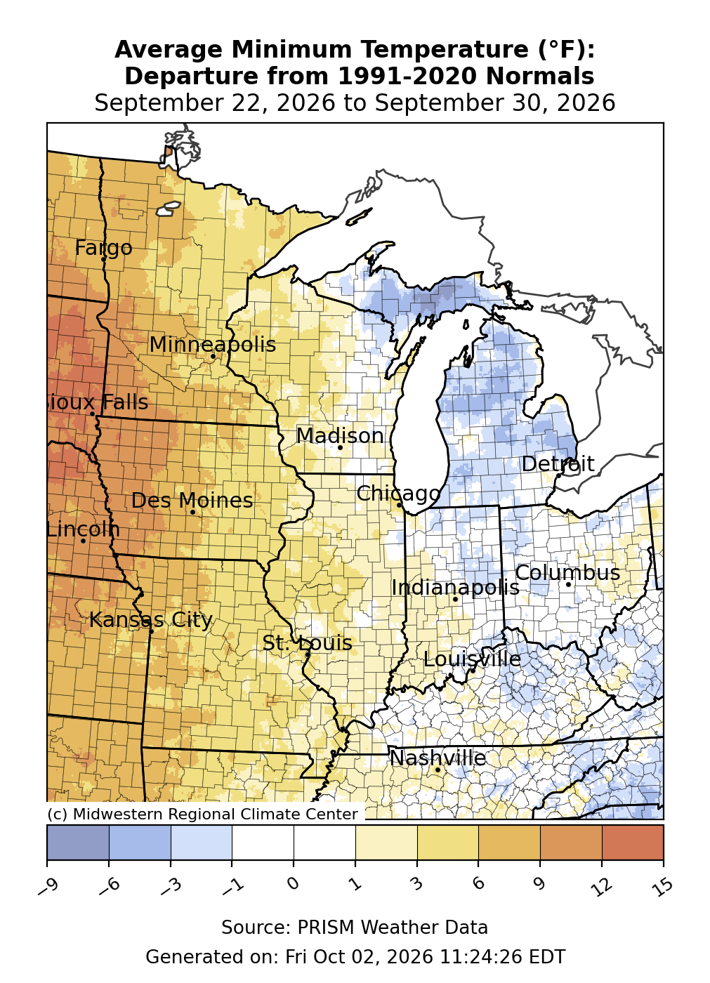
Minimum temperatures averaged above normal west of the Mississippi River (Figure 2). The westernmost areas of Iowa and Minnesota were roughly 10°F above normal for the week. Most areas along and west of the Mississippi River were 3-6°F above normal. Much of Wisconsin and Illinois were 1-3°F above normal. Minimum temperatures were roughly near normal across Indiana, Ohio, and Kentucky. Much of Michigan saw minimum temperatures 1-3°F below normal, with isolated areas 3-6°F+ below normal.
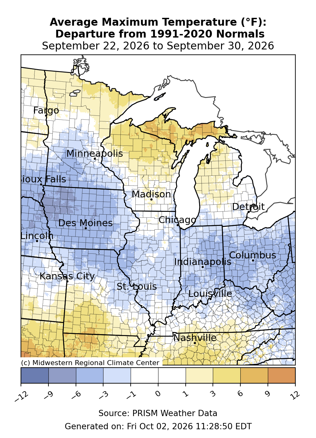
The northernmost and southernmost reaches of the region observed near or above normal maximum temperatures (Figure 3). Michigan’s Upper Peninsula (UP) was 6-9°F above normal in spots, while northern Wisconsin and southern Missouri were 3-6°F above normal. Everywhere in between observed maximum temperatures that were below normal, often by 3-6°F.
Record September Warmth
This week concluded a record warm September for many observing locations. Indianapolis observed its warmest September on record since records began in 1874 with an average temperature of 73.8°F. St. Louis observed 16 days of temperatures at or above 90°F, the 2nd most on record for any September since records began in 1874. Columbia, Missouri, observed 16 days of temperatures at or above 90°F, the 2nd most on record for any September since records began in 1874. Springfield, Missouri, observed 19 days of temperatures at or above 90°F, the second most on record for any September since records began in 1874. Springfield also observed 16 days when temperatures rose to or above 95°F, the most 95°F+ days on record in Springfield in September since records began in 1874. In Paducah, Kentucky, the temperature rose to or above 95°F for 13 days in September, the most on record since records began there in 1937. It was the 2nd warmest September on record in Paducah since records began in 1937.
Precipitation/Drought
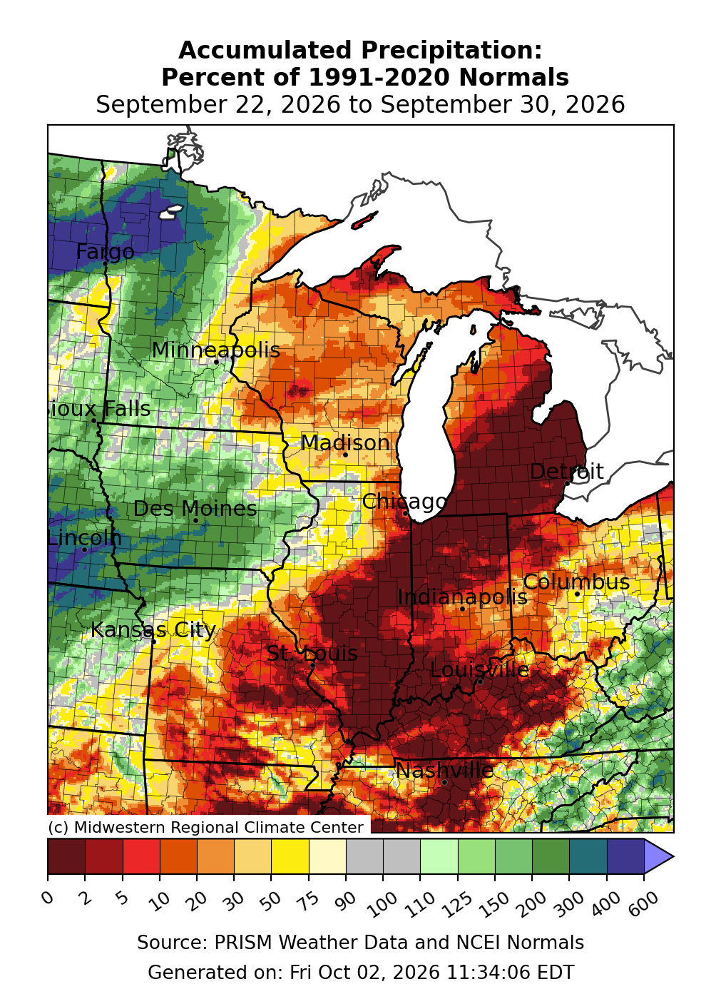
Precipitation was below normal everywhere from Michigan to Kentucky (Figure 4). There was less than 10 percent of normal precipitation across Illinois, Indiana, Kentucky, Michigan, eastern Missouri, and western Ohio. Across Iowa and Minnesota, precipitation was often over 150-200 percent of normal, and across northwestern Minnesota it was over 400 percent of normal.
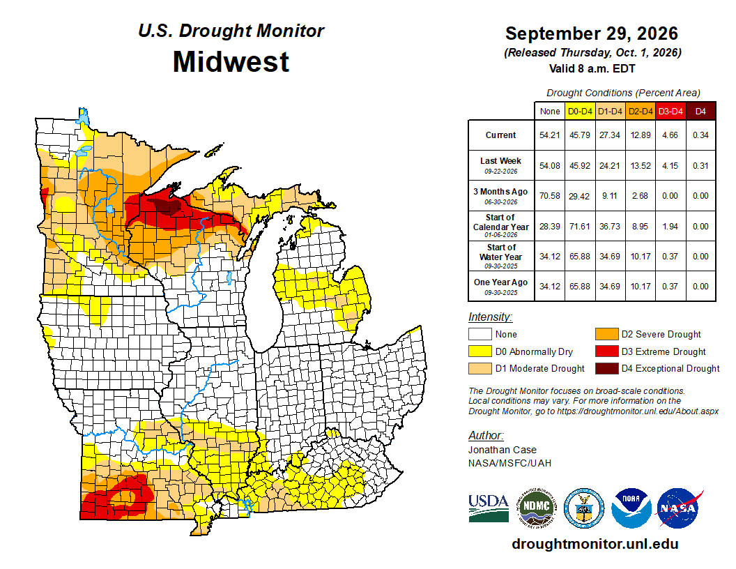
Drought improvements and degradations were minimal from September 22 to September 29 (Figure 5). D0 (abnormally dry) coverage remained largely unchanged, with minor improvements in Kentucky, northwestern Minnesota, and Wisconsin offset by increasing dryness across Michigan’s UP and Kentucky. D1 (moderate drought) saw the largest change, increasing by more than 3 percent, with expansions across Michigan’s UP, Missouri, and Illinois. D3 (severe drought) and D4 (extreme drought) remained mostly unchanged, with slight changes in both directions in Missouri and Wisconsin.