July 15-21, 2026
July 15-21, 2026
Temperature
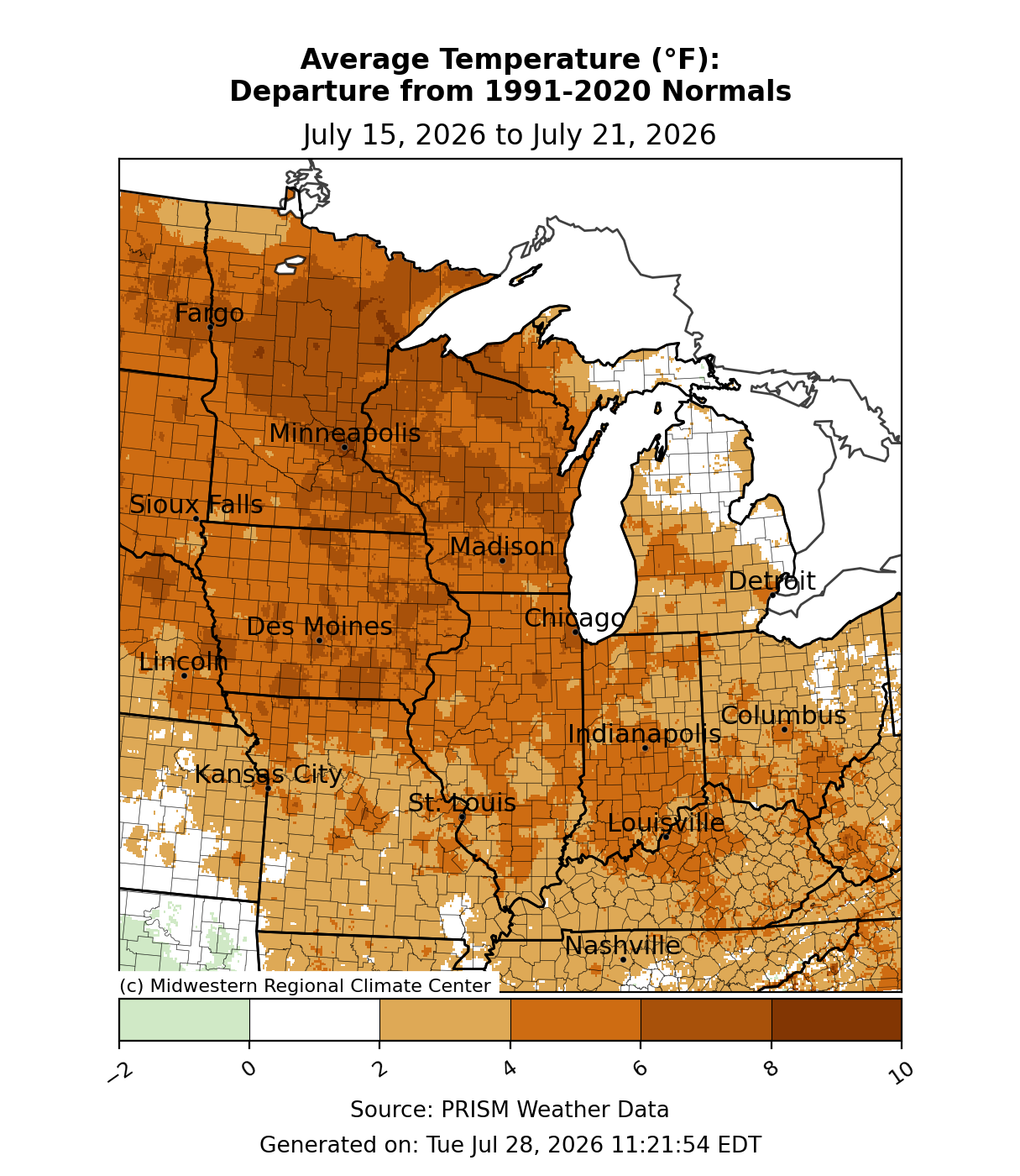
Average temperatures were above normal (Figure 1). Across Kentucky, Missouri, Ohio, and Michigan, temperatures were generally 2-4°F above normal. Some parts of Michigan were near normal, while northern Missouri, northern Kentucky, and western parts of Michigan’s Upper Peninsula (UP) were up to 6°F above normal for the week. Illinois and Indiana were 3-6°F above normal. Across Iowa, Minnesota, and Wisconsin, average temperatures were up to 8°F above normal.
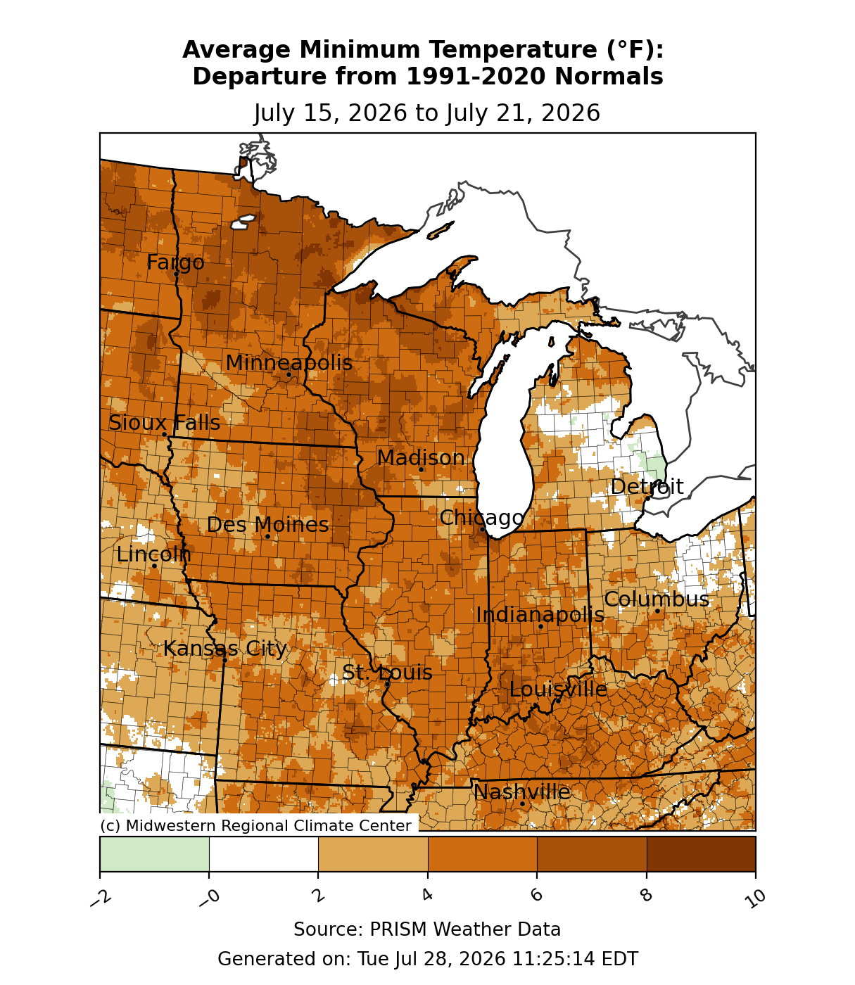
Minimum temperatures averaged 3-6°F above normal for much of the region (Figure 2). In parts of the Upper Midwest, particularly far northern Wisconsin and Minnesota, temperatures were up to 10°F above normal. Eastern Ohio and eastern Michigan were near normal.
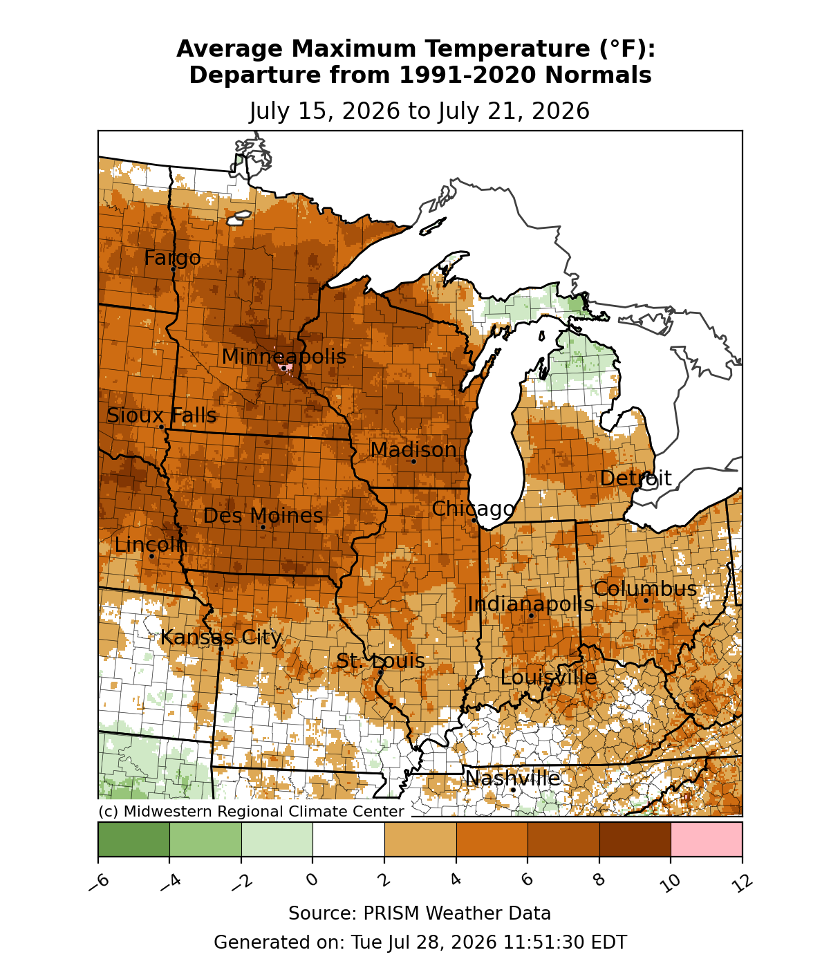
Maximum temperatures were 6-8°F above normal across much of Iowa, Minnesota, and Wisconsin (Figure 3). Across Illinois, Indiana, Ohio, northern Missouri, and southern Michigan, maximum temperatures were generally 4-6°F above normal. Maximum temperatures were near normal across western Kentucky and southern Missouri for the week. Only across northern Lower Michigan and Michigan’s eastern UP were maximum temperatures slightly below normal.
Precipitation/Drought
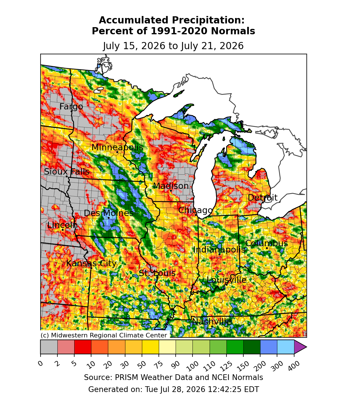
Precipitation was scattered in nature, with mostly below-normal precipitation and pockets of above-normal precipitation (Figure 4). Across central and eastern Iowa, Minnesota’s Arrowhead region, and northern Michigan, precipitation was above normal, often exceeding 200 percent of normal. Much of the rest of the region was below normal, and some sections of the upper Midwest observed no measurable precipitation. Only across Indiana, Kentucky, Ohio, and southern Missouri, where pockets of thunderstorms occurred, was there near-normal precipitation.
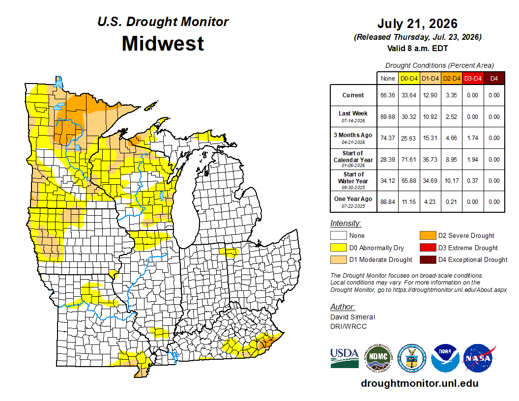
Given the scattered nature of precipitation, there were minor degradations in drought conditions from July 14 to July 21 (Figure 5). D0 conditions (abnormally dry) increased in coverage to just over 3 percent of the region, with most occurring over the Upper Midwest. D1 conditions (moderate drought) were removed slightly from northern Wisconsin, while they expanded over western Iowa and northern Minnesota. D2 conditions (severe drought) improved across Michigan’s UP, while conditions degraded over northern Minnesota.
Severe Weather
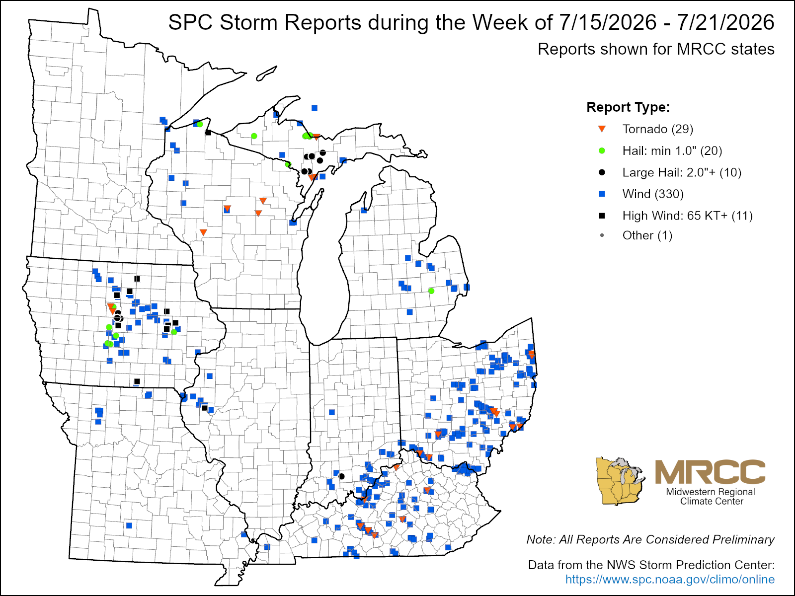
There were over 300 reports of severe weather this week (Figure 6). At least 330 were wind reports, 29 were tornado reports, and 20 were hail reports. Most of these occurred with a system that moved through the region late in the week, beginning in Iowa, Michigan, and Wisconsin, where several brief tornadoes were reported. Large hail the size of baseballs was reported in Michigan’s UP. At least two EF1 tornadoes with estimated peak winds ranging from 90-104 mph were reported across Michigan’s UP. These were the first confirmed tornadoes to touch down across Michigan’s UP in 5 years. Severe weather then moved east, spawning at least 10 tornadoes across Kentucky and Ohio on July 21. The strongest of these tornadoes touched down in Grayson County, Kentucky before spending 21 miles on the ground, mostly in Hart County. This tornado was an EF2 with estimated peak winds of 115 mph and caused one head injury in Gray County near Nolin Lake. An EF1 tornado with peak winds of 110 mph spent 21 miles on the ground across four Kentucky counties—Carroll, Gallatin, Owen, and Grant. This tornado caused one injury when a large RV was rolled in Owen County.