July 1-7, 2026
Temperatures
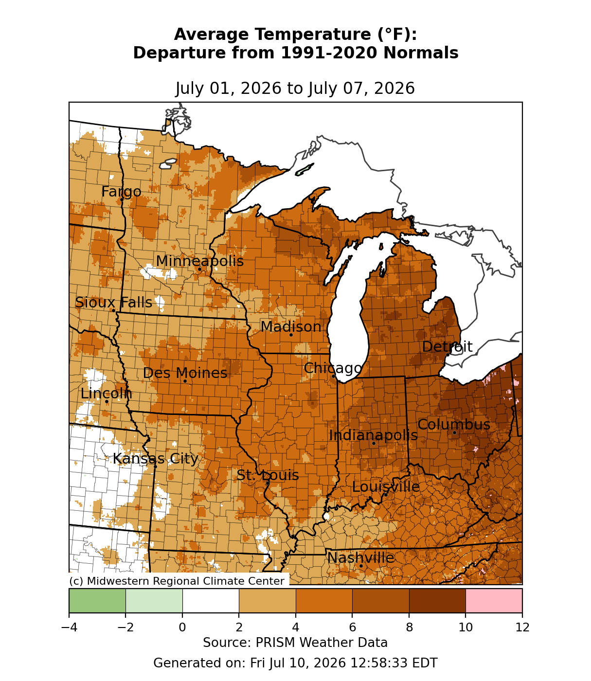
Temperatures were above normal, particularly early in the week as a heat dome lingered across the region (Figure 1). Eastern locales such as Indiana, Michigan, and Ohio, average temperatures were 5-10°F above normal. Across Illinois, Kentucky and Wisconsin, temperatures averaged roughly 3-6°F above normal. West of the Mississippi River, temperatures averaged mostly 2-4°F above normal, with slightly higher departures immediately along the river.
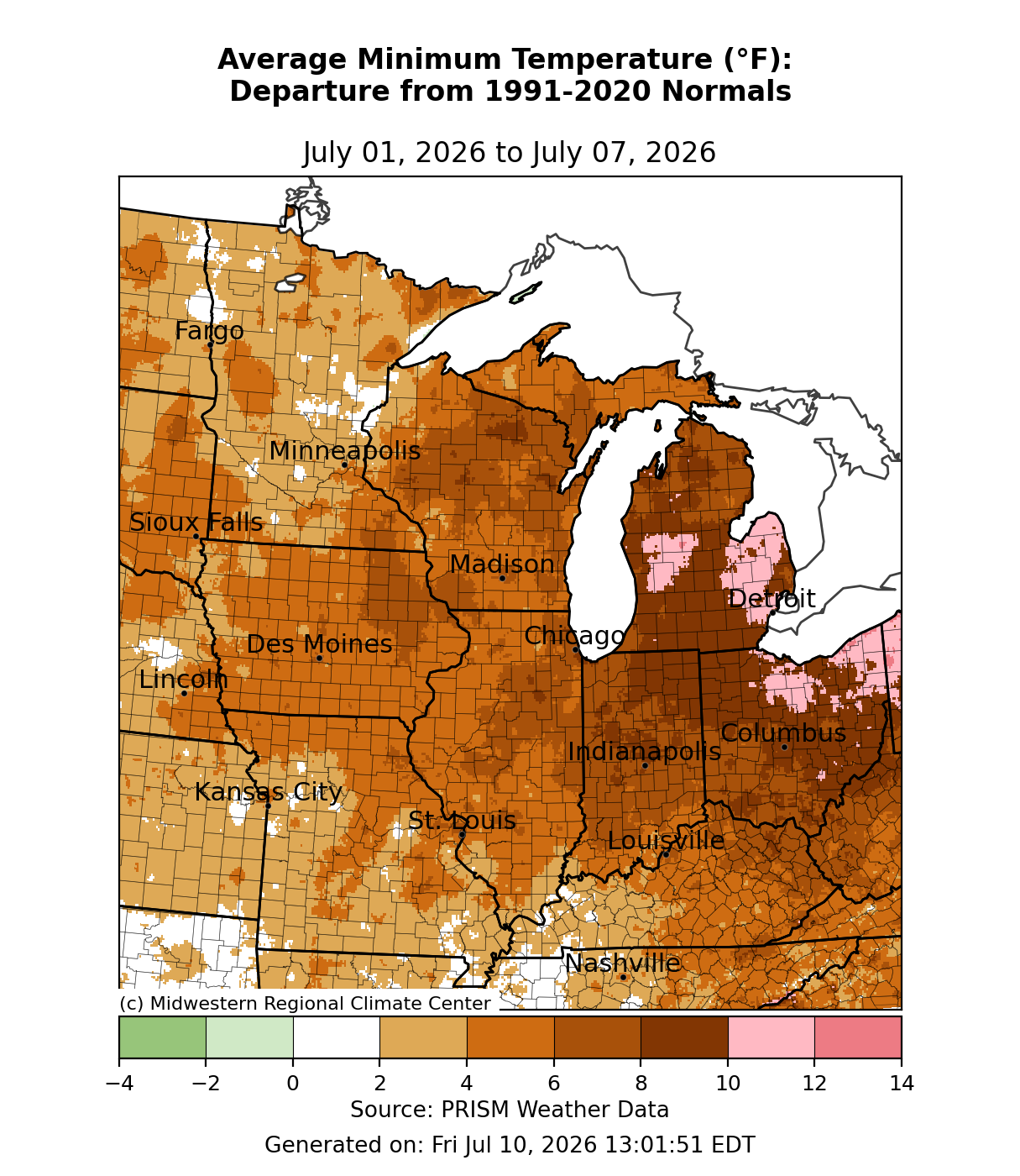
Minimum temperatures were most above normal to the east (Figure 2). Across parts of northern Ohio and Lower Michigan, minimum temperatures were 10-12°F above normal. Most of the region observed minimum temperatures that were 5-10°F above normal. Areas west of the Mississippi River observed the smallest departures, with minimum temperatures in parts of Minnesota and Missouri just 2-4°F above normal. In Flint, Michigan, minimum temperatures remained at or above 75°F for two consecutive days, July 1-2, for the first time in July since 1977. In Grand Rapids, minimum temperatures remained at or above 75°F for three consecutive days, June 30-July 2, for the first time since 2013.
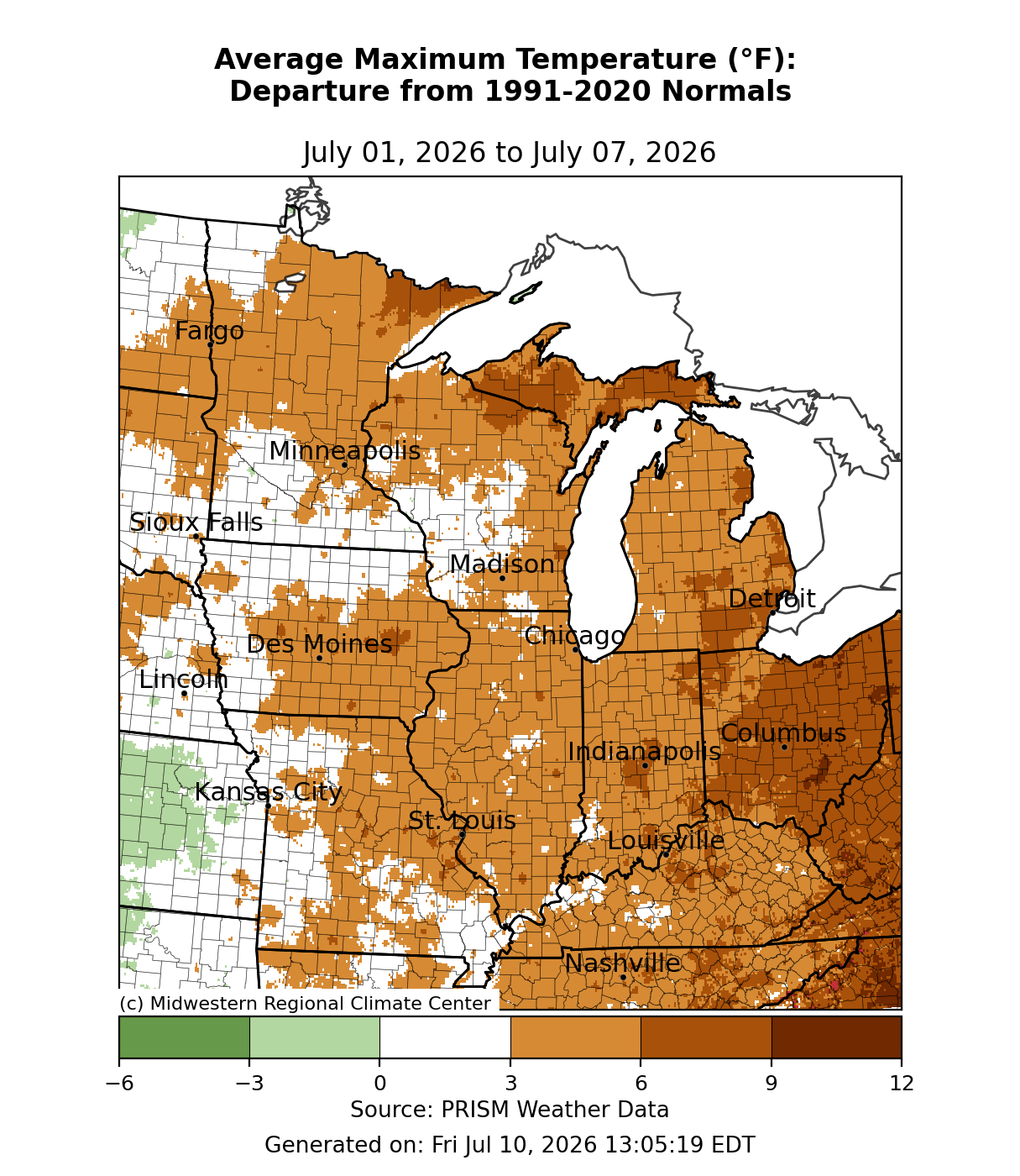
Maximum temperatures were 6-9°F above normal across Michigan’s Upper Peninsula (UP), Minnesota’s Arrowhead region, eastern Michigan, and Ohio (Figure 3). Across the rest of the region, maximum temperatures were 3-6°F above normal, though some of the western areas were closer to normal for the week.
Precipitation/Drought
Precipitation was most above normal along I-80 from northern Ohio through Iowa and southern Minnesota (Figure 4). Some cities including, but not limited to, Des Moines, Iowa; Chicago, Illinois; South Bend, Indiana; and Toledo, Ohio received over 300-400 percent of normal precipitation for the week. In Goshen, Indiana, 1.82 inches of precipitation was observed on July 4 making it the wettest Independence Day on record there since records began in 1914. Other parts of the region did not see nearly as much precipitation, which included many areas along and south of the I-70 corridor, as well as some of the northernmost parts of the region. There was little to no precipitation across Michigan’s UP, northern Wisconsin, Missouri, Kentucky, southern Indiana, and southwestern Ohio.
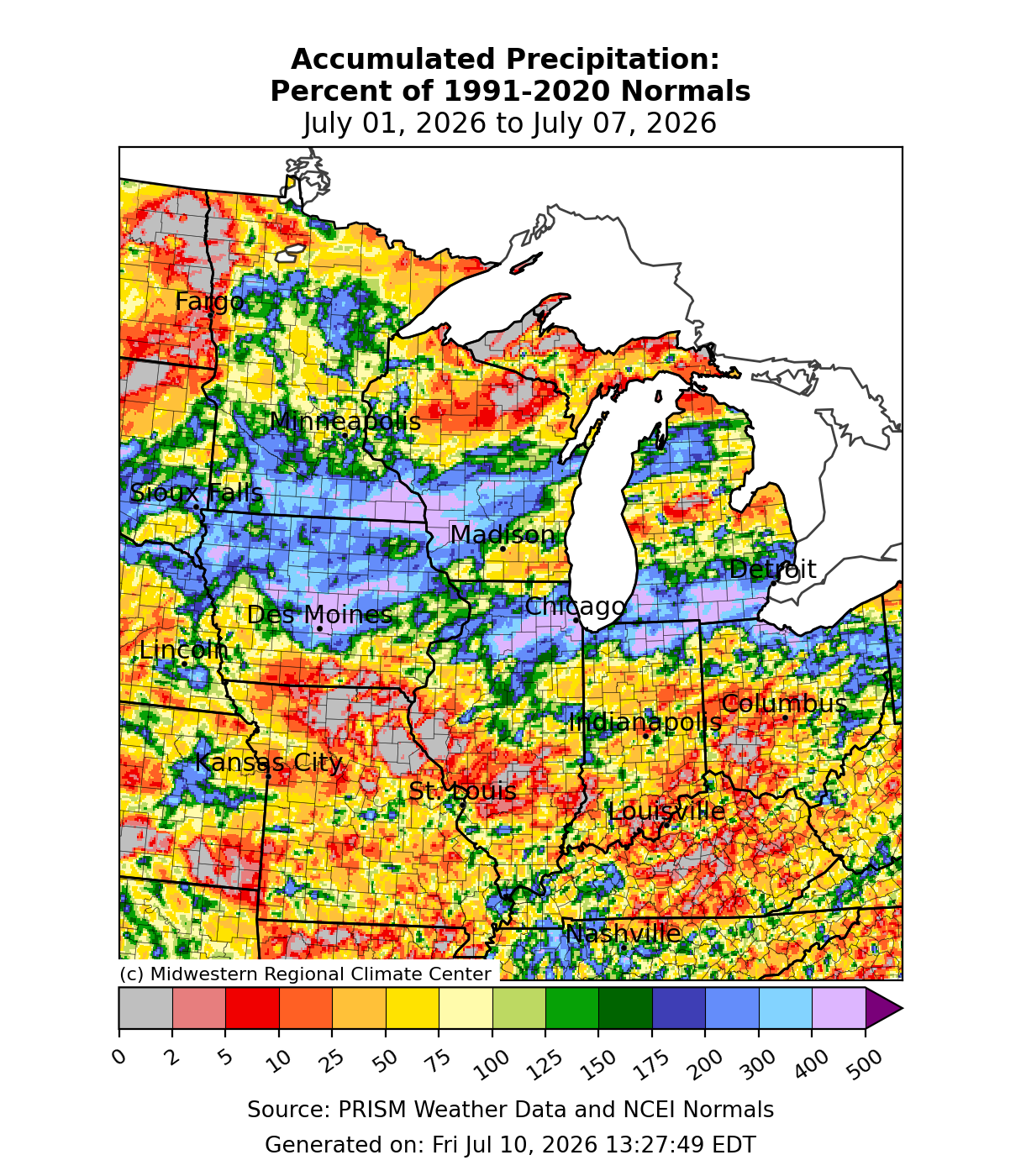
Significant rainfall resulted in flash flooding across parts of Illinois, Iowa, and Minnesota July 2-3. Over 10 inches of rain occurred just on the north side of Des Moines, Iowa, which resulted in Fourmile Creek at Easton Boulevard cresting at 16.87 feet, the 2nd highest crest ever behind only the 2018 Central Iowa flash floods. Several people were stranded in flash flooding across Story County, Iowa. Some parts of southeastern Minnesota observed over 12 inches of rain, though dry antecedent soil conditions limited the extent of flooding. In the Chicago area, some rain gauges reported rain rates of 3-4 inches per hour. . The Deep Tunnel, a systsem of underground tunnels and reservoirs built to keep floodwaters out of Chicago and protect Lake Michigan, was nearly full after the two day rain event.
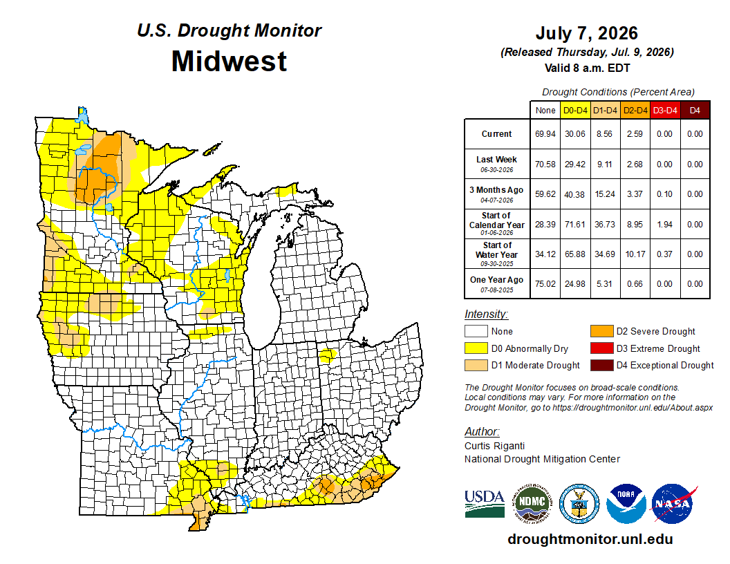
There were minimal changes to drought conditions across the Midwest from June 30 to July 7 (Figure 5). There was a slight 0.64 percent increase in D0 (abnormally dry) conditions, which occurred mostly over Missouri and southern Illinois. Improvements were less than 1 percent across the region for the D1 (moderate drought) and D2 (severe drought) categories and were concentrated mostly over Minnesota.
Severe Weather
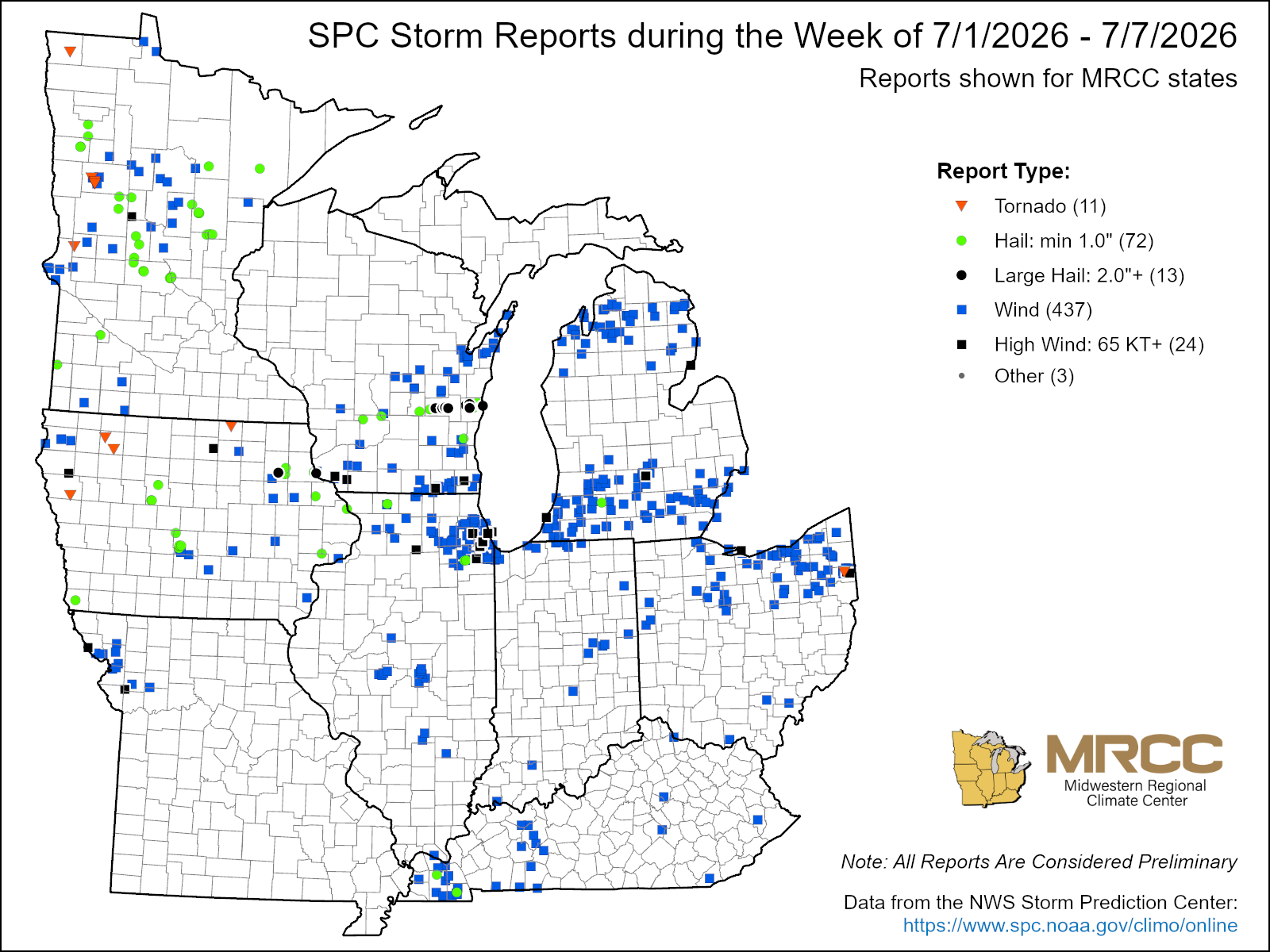
There were over 500 storm reports this week (Figure 6). More specifically, there were 437 wind reports, 72 hail reports, and 11 tornado reports. On July 1, severe weather across Wisconsin produced 2-3 inch hail in Fond Du Lac and Sheboygan counties. On July 2, hail reaching 3-3.5 inches in diameter—nearly the size of baseballs—were reported in Iowa. On July 3, a downburst in Wisconsin produced straight-line wind gusts of 100 mph in Walworth County. Winds from this storm struck near the town of Darien where five people were injured by falling concrete. The same storm then crossed Lake Geneva, a popular boating destination, where a boat carrying 10 people drowned causing seven injuries and three deaths. Later in the week, an EF2 tornado with estimated peak winds of 115 mph caused 2 injuries in Becker County, Minnesota, which is in the state’s northwestern quadrant.