April 2026
April 2026 Overview – Midwestern Regional Climate Center
Temperature
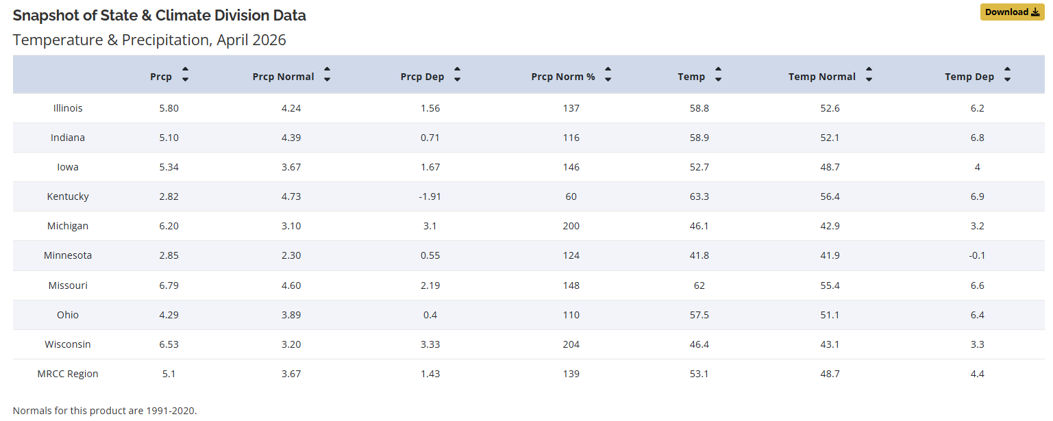
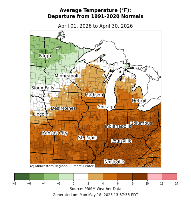
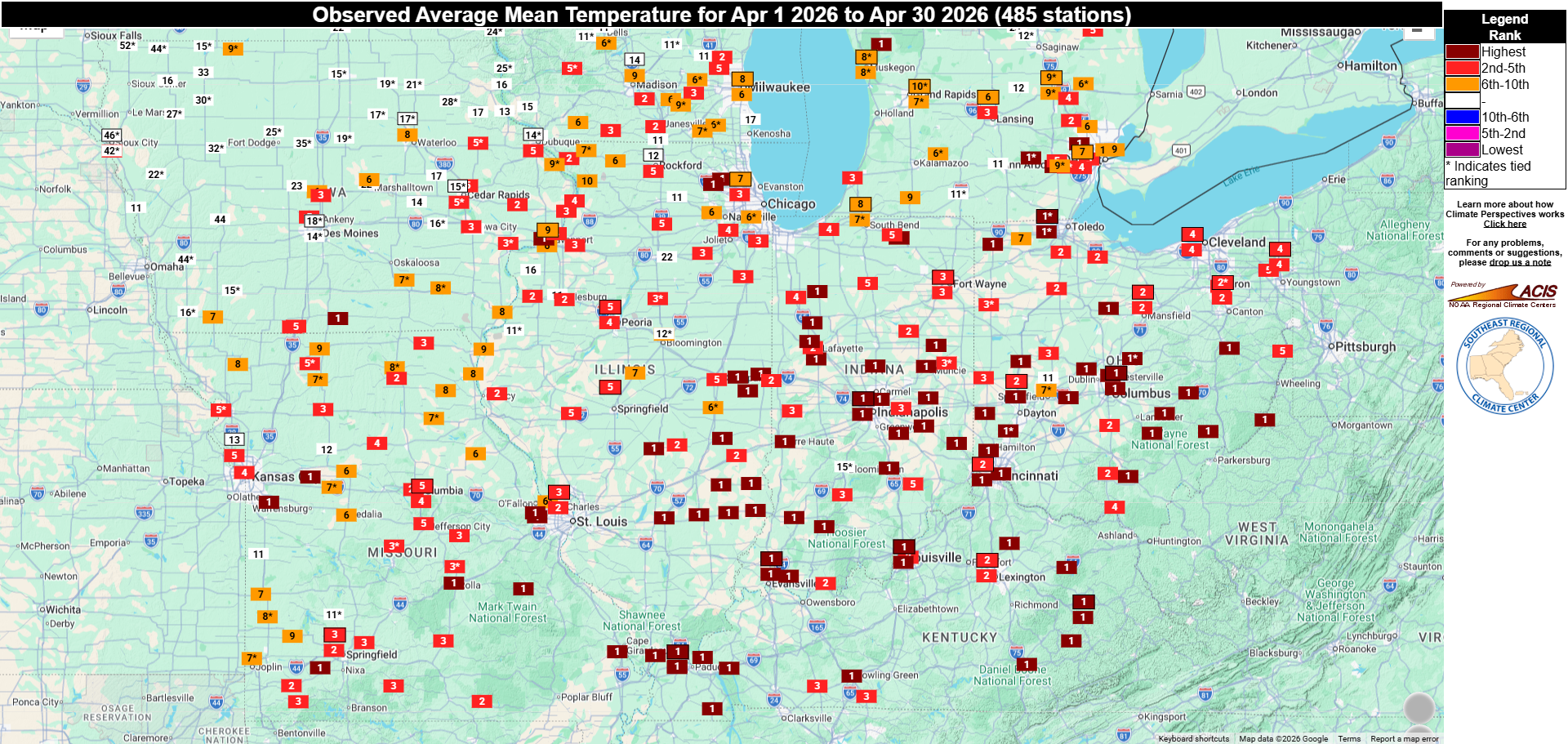
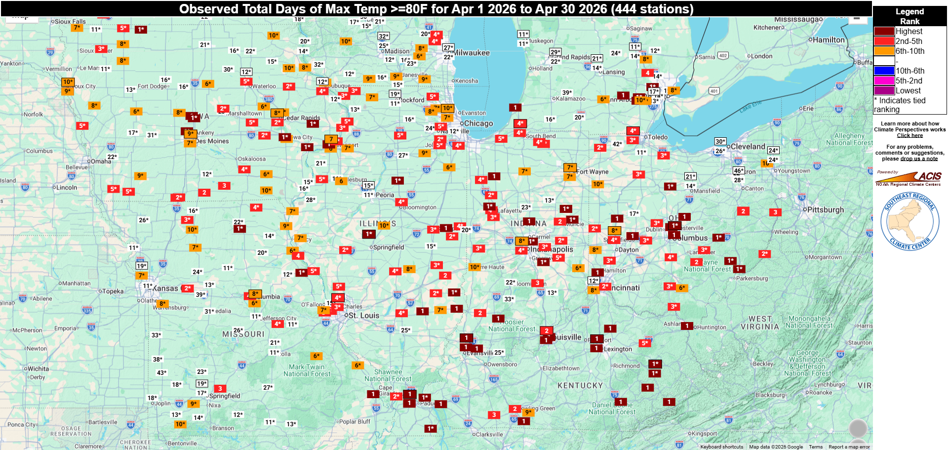
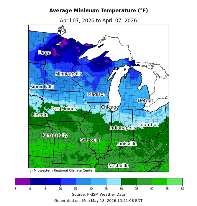
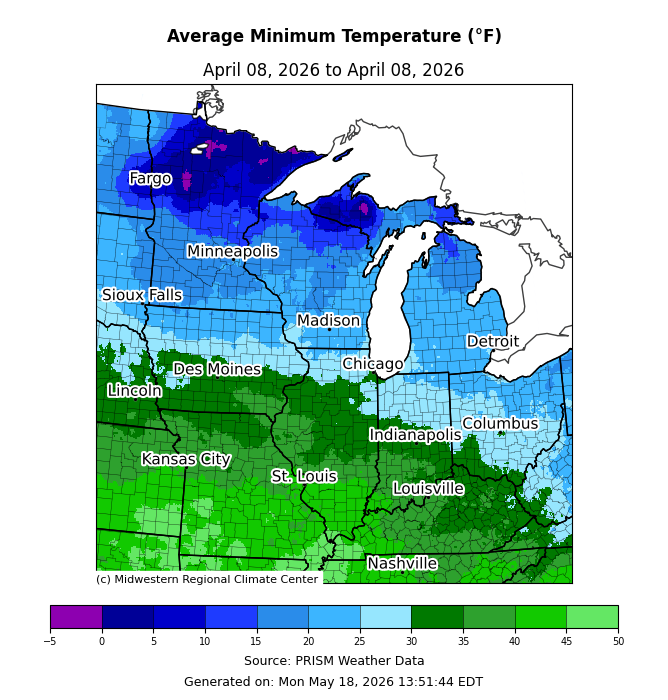
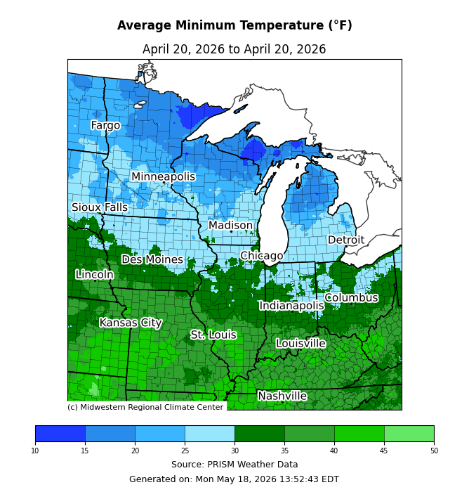
The average April temperature for the Midwest was 53.1°F, which was 4.4°F above the 1991-2020 normal (Figure 1). Final rankings indicate that the Midwest had its 7th warmest April on record. Monthly temperatures ranged from 2 to 4°F below normal in the far northwest and up to 6 to 10°F above normal across a wide swath in the southeastern half of the region (Figure 2). Statewide average temperatures ranged from 0.1°F below normal in Minnesota to 6.9°F above normal in Kentucky. Final rankings indicate that Illinois, Indiana, Kentucky, Missouri, and Ohio had their warmest April on record. Numerous long-running weather stations across the lower Midwest had a top 5 warmest April, with the following cities all reporting their warmest April on record: Paducah (KY), Louisville (KY), Jackson (KY), Evansville (IN), Indianapolis (IN), Columbus (OH), and Toledo (OH) (Figure 3). Additionally, most long-running weather stations across the lower Midwest ranked in the top 10 for the total number of days with maximum temperatures at or above 80°F (Figure 4). Springfield, Illinois, which has 146 years of data, reported 11 days in April with temperatures at or above 80°F, tying the record. While temperatures were persistently warmer than normal across the lower Midwest, Wisconsin, and Michigan, the region still had a couple of brief punches of chilly air in April. Regionwide, the coldest low temperatures of the month blanketed the region on April 7 (Figure 5) and April 8 (Figure 6), with temperatures in the 20s and 30s in the south and sub-zero to teens in the north. Another shot of chilly air spread across the region around April 20, bringing freezing to near-freezing temperatures from the central Midwest northward (Figure 7). Notably, though, the majority of areas across Missouri, southern Illinois, southern Indiana, and Kentucky did not report sub-freezing temperatures at all in April, which is atypical, since the median last-spring freeze date for these areas is early to mid-April.
Precipitation
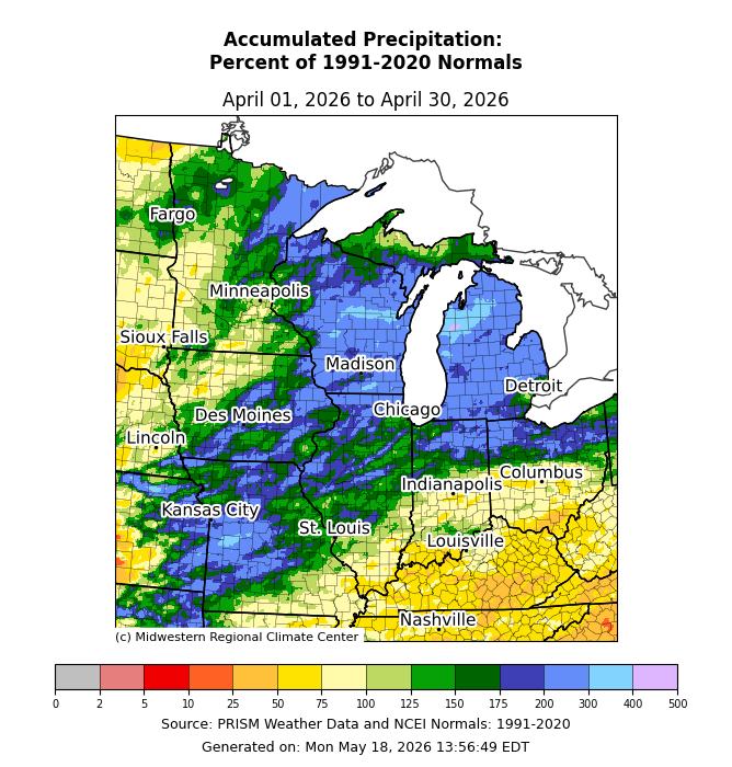
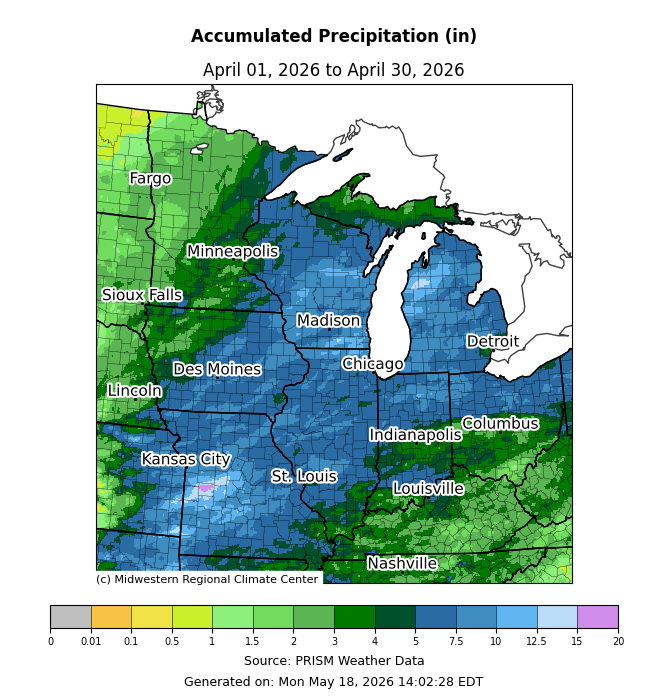
April precipitation totaled 5.10 inches for the Midwest, which was 1.43 inches above normal, or 139 percent of normal (Figure 1). Final rankings indicate that the Midwest had its 3rd wettest April on record. Precipitation was 200-400 percent of normal across a wide swath from Missouri northeastward across the Great Lakes (Figure 8). Conversely, precipitation was 25-75 percent of normal along and south of the Ohio River. Statewide precipitation totals ranged from 1.91 inches below normal in Kentucky to 3.33 inches above normal in Wisconsin. Final rankings indicate that Michigan and Wisconsin had their wettest April on record, while Iowa, Missouri, and Illinois had their 6th, 10th, and tied-15th wettest April, respectively. A combination of persistent precipitation and multiple extreme events drove the remarkable wetness across the Midwest. Throughout Michigan, measurable precipitation fell on about 14-24 days. In northwest Michigan, Wellston reported 15.68 inches for April, making it the wettest among the 105 years of data available and exceeding the previous April monthly record by 9.08 inches (Figure 9). Measurable precipitation fell on 18 of 30 days, and Wellston measured its greatest 2-day precipitation total on record when 6.93 inches fell from April 13-14, 2026. Widespread river flooding ensued across the Lower Peninsula in response to heavy rain and rapidly melting snowpack. On April 14, a levee on the Little Black River breached, which prompted an evacuation order for low-lying areas near Cheboygan, Michigan. The Muskegon River crested at record levels in multiple locations, including at Bridgeton, Michigan, and Newaygo, Michigan, where it rose to 19.7 feet and 17.9 feet, respectively. In Green Bay, Wisconsin, 4.52 inches of precipitation fell between April 12-14, making it the wettest 3-day period in April since records began there in 1886. To the west, Clintonville, Wisconsin, had a record-setting 12.58 inches of precipitation for April, breaking the previous record by 7.21 inches. In southeast Wisconsin, multiple counties had monthly precipitation totals of 10 to 12.5 inches, and rainfall exceeded 1 inch on 3 to 5 individual days. Burlington measured 4.08 inches on April 18 alone. In west-central Missouri, 10 to 15 inches of precipitation fell across a wide, multi-county area in April. Sedalia, Missouri, picked up 13.38 inches, its wettest April in 99 years of record-keeping.
Drought
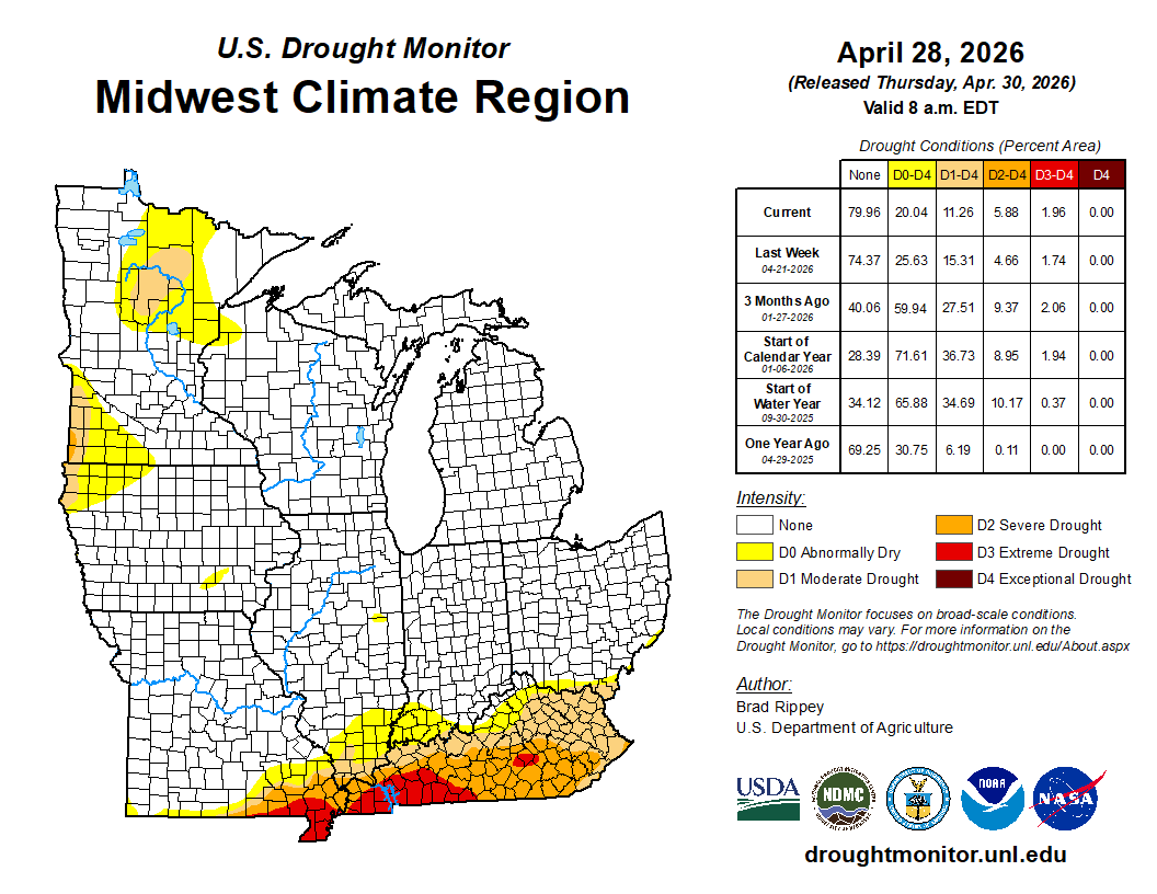
Conditions continued to improve through April in the central and upper Midwest, with notable deterioration in the far southern Midwest (Figure 10). April ended with 20 percent of the region abnormally dry or in drought, a 33 percent reduction from the end of March. The worst drought conditions were in Kentucky, where 90 percent of the state was moderate (D1) to extreme (D3) drought according to the U.S. Drought Monitor map. Severe (D2) and extreme (D3) drought were also present across southeastern Missouri. Drought affected a small portion of northern Minnesota, southwest Minnesota, and extreme northwest Iowa. The majority of the Midwest was free of drought or abnormal dryness.
Severe Weather
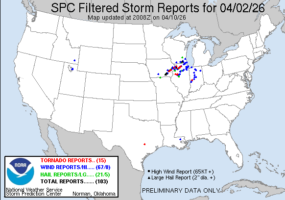
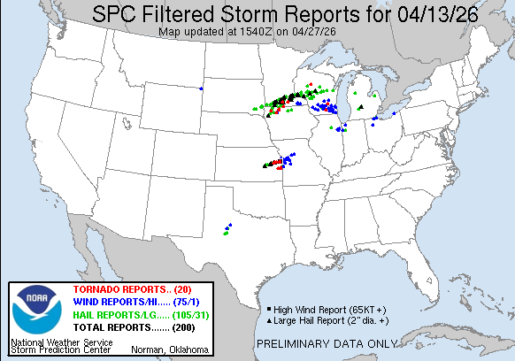
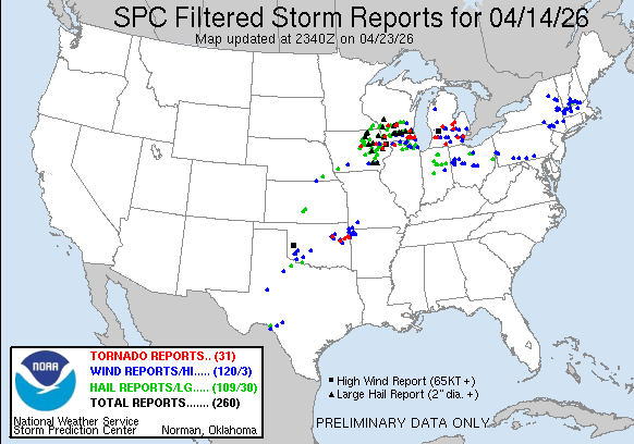
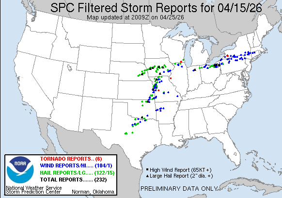
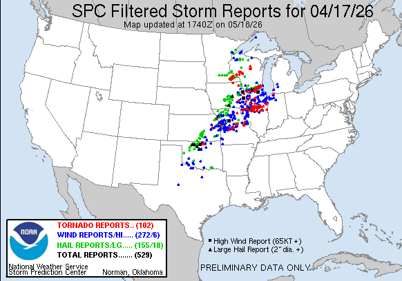
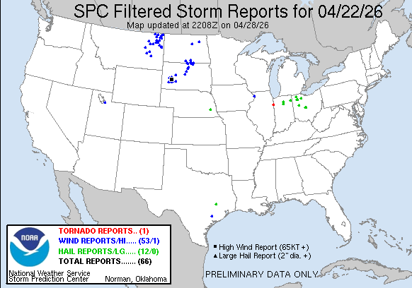
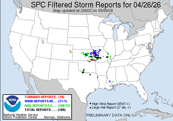
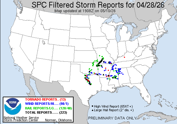
A very active weather pattern brought widespread severe weather—including tornadoes, large hail, and damaging winds—to parts of the region on numerous days, including April 2 (Figure 11), 13 (Figure 12), 14 (Figure 13), 15 (Figure 14), 17 (Figure 15), 23 (Figure 16), 26 (Figure 17), and 28 (Figure 18). For the entire month, there were at least 176 tornadoes confirmed across the Midwest, with at least 65 of those in the state of Illinois alone. For comparison, the Midwest average tornado count for April is 47, with just 11 in Illinois.
The April 17 tornado and severe weather outbreak was the largest among all the outbreaks this month, with over 80 tornadoes confirmed by the National Weather Service, affecting Illinois, Indiana, Iowa, Missouri, Minnesota, and Wisconsin. In addition to tornadoes, 1 to 3 inches of heavy rainfall, wind gusts of 50 to 70 mph, and golf ball to baseball-sized hail were reported across the region.