April 8-14, 2026
April 8-14, 2026
Temperature
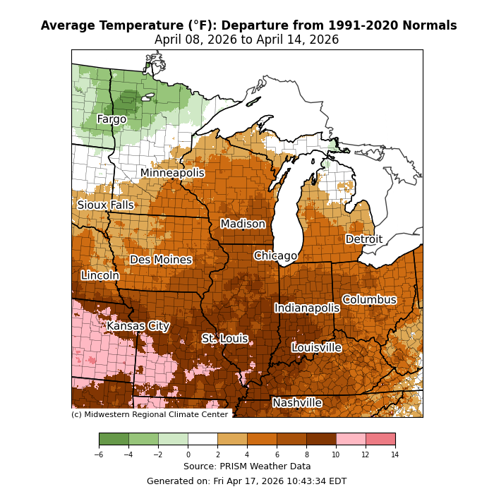
Average temperatures were mostly above normal (Figure 1). Average temperatures were 2-8°F above normal across much of the Upper Midwest and 6-12°F above normal from I-80 southward. In northern Minnesota, average temperatures were slightly below normal by 2-6°F.
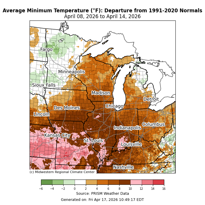
Minimum temperatures were above normal by 4-10°F for many places south of I-80 (Figure 2). Across parts of southern Indiana, southern Illinois, and Missouri, minimum temperatures were 10-12°F above normal. Parts of the Upper Midwest were 2-6°F above normal, though much of northern lower Michigan and Minnesota were near normal.
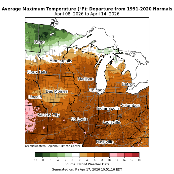
Maximum temperatures were above normal by 4-8°F for much of the region (Figure 3). Across southern parts of the region, maximum temperatures averaged up to 10°F above normal, while some of the region’s northernmost locations were near to below normal for the week.
Precipitation/Drought
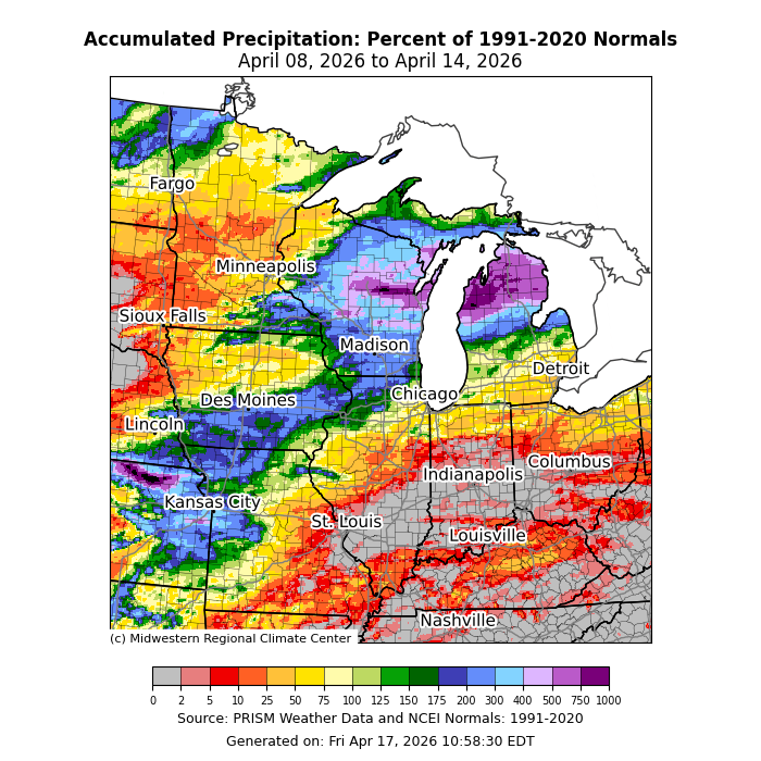
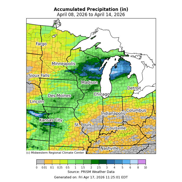
Precipitation was well above normal across parts of Wisconsin and Michigan, where as much as 750-1000 percent of normal precipitation was observed (Figure 4). Much of Illinois, Indiana, Kentucky, and Ohio observed below normal precipitation, if any at all. Precipitation was varied for areas west of the Mississippi River. While cities like Kansas City, Missouri, and Des Moines, Iowa, observed near- to above-normal precipitation, precipitation was below normal in much of Minnesota, including the Twin Cities.
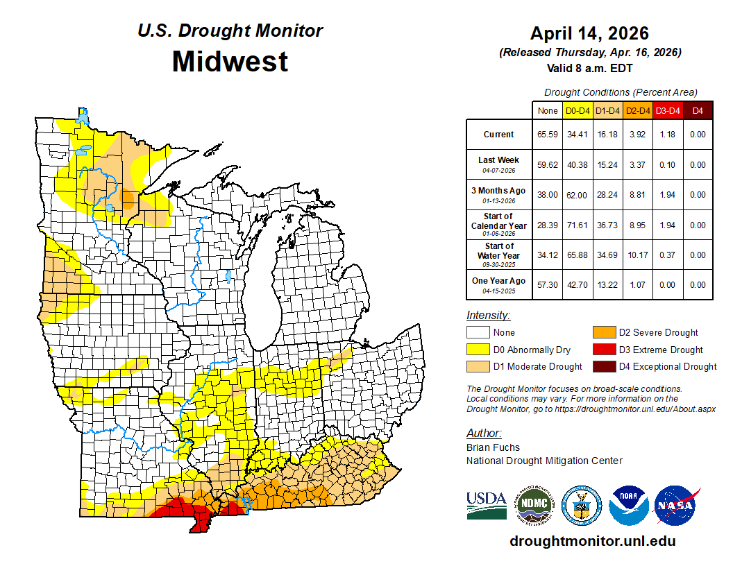
As of April 14, drought conditions were varied across the region. Improvements were made across Iowa, Illinois, and northern Missouri, all of which saw precipitation in the prior week. D1 (moderate drought), D2 (severe drought), and D3 (extreme drought) all expanded slightly across Kentucky and southern Missouri (Figure 5).
Upper Midwest River Flooding
Precipitation was most abundant across parts of central Wisconsin and northern lower Michigan. Some areas received up to 8 inches of precipitation this week alone (Figure 6). In Green Bay, Wisconsin, 4.52 inches of precipitation fell between April 12-14, making it the wettest 3-day period in April since records began there in 1886. 1.82 inches of precipitation fell in Green Bay on April 13, making it the wettest April day there since 1994. In Houghton Lake, Michigan, 2.97 inches of precipitation fell on April 12, making it the wettest April day there since records began in 1913. Heavy precipitation, combined with warming temperatures and a rapidly melting snowpack, resulted in widespread river flooding across the Lower Peninsula. On April 14, a levee on the Little Black River breached, which prompted an evacuation order for low-lying areas near Cheboygan, Michigan. The Muskegon River crested at record levels in multiple locations, including at Bridgeton, Michigan, and Newaygo, Michigan, where it rose to 19.7 feet and 17.9 feet, respectively.
Severe Weather
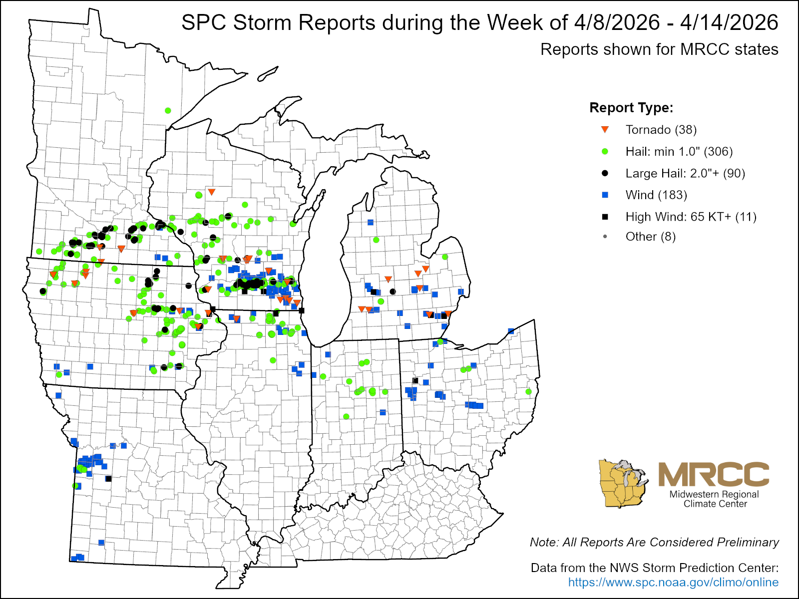
There were over 500 reports of severe weather this week, with over 300 reports of hail alone (Figure 7). Many of these occurred in Iowa, Minnesota, and Wisconsin, though almost every state in the region was affected. Many of the hail reports were made on April 13 across Minnesota and Wisconsin. In Minnesota, egg-sized hail was reported in Rice County. In Watonwan County, Minnesota, there were reports of tennis-ball-sized hail. A supercell on April 14 produced 3-inch hail, the size of baseballs, in Buchanan County, Iowa.
Tornadoes were also prevalent this week. The National Weather Service office in the Quad Cities area has confirmed 4 tornadoes as of this writing, 3 of which reached EF1 strength. The National Weather Service office in La Crosse, Wisconsin, confirmed one EF1 tornado on April 13 and an EF3 tornado with estimated peak winds of 140 mph on April 14. In Michigan, at least 6 tornadoes were confirmed on April 14.