March 8-14, 2026
Temperatures
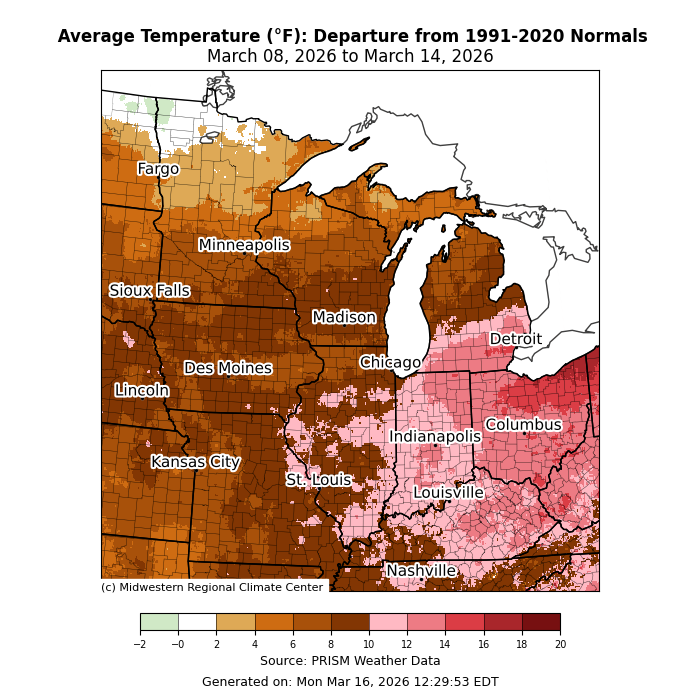
Temperatures were above normal for the entire region (Figure 1). The greatest departures were across the Ohio Valley, with areas near Cleveland, Ohio, as much as 16-18°F above normal for the week. Anomalies were lower to the north and west, with most of the region anywhere from 6-12°F above normal.
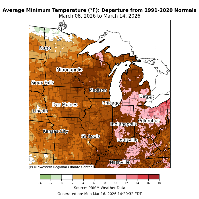
Minimum temperatures were above normal for the entire region (Figure 2). Across the east, minimum temperatures were as much as 12-14°F above normal. Heading north and west, much of the region was 5-10°F above normal. In Indianapolis, Indiana, a minimum temperature of 64°F was observed on March 10, which was the warmest minimum temperature in March since 2012 and tied for the second warmest March minimum temperature on record.
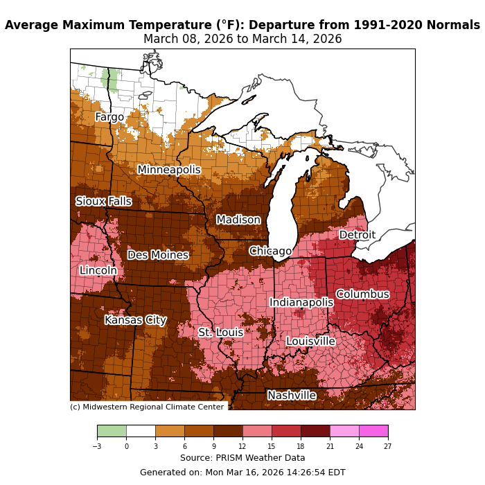
Maximum temperatures were well above normal (Figure 3). The entire state of Ohio, southeastern Michigan, and northeastern Indiana were over 15°F above normal for the week. Many areas from St. Louis, Missouri, to Louisville, Kentucky, were 12-15°F above normal for the week. Maximum temperature departures were lower to the north and west, though still above normal by 5-10°F. Maximum temperatures were closer to normal for the week across the far north. In Chicago, temperatures remained above 60°F for five consecutive days from March 6 to March 10, the longest such stretch in March since 2012.
Precipitation/Drought
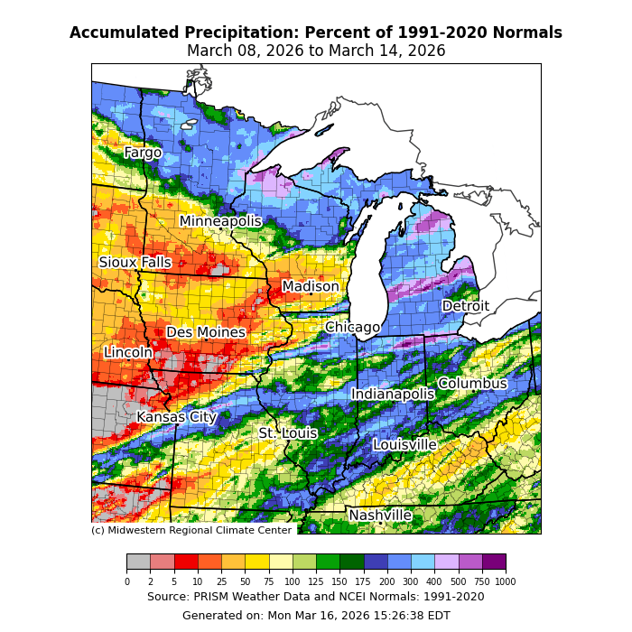
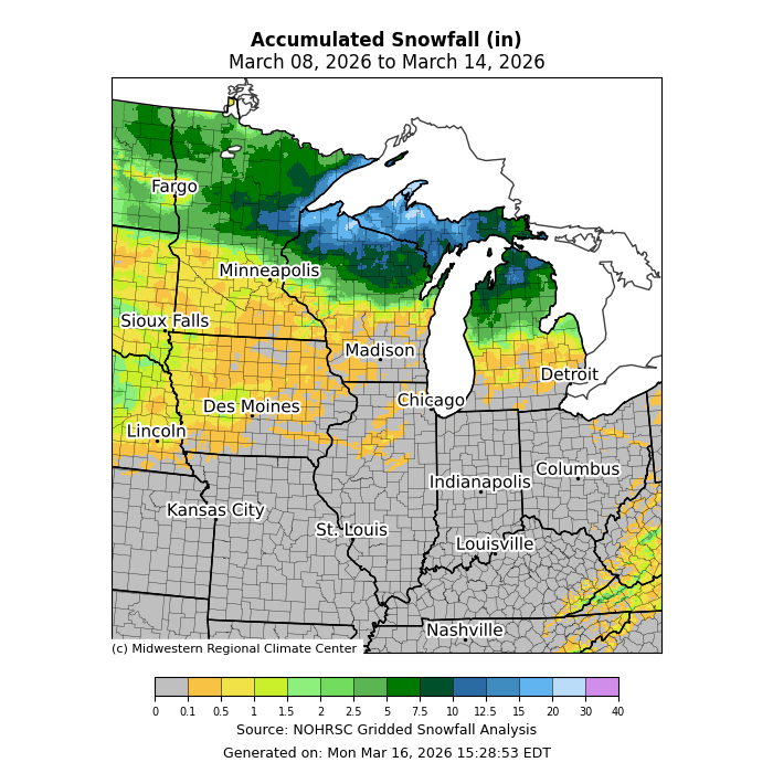
Precipitation was abundant across the Upper Midwest, where northern Minnesota, Michigan, and northern Wisconsin all observed precipitation at least 200 percent of normal (Figure 4). Some parts of Illinois, Indiana, Missouri, and Ohio saw similarly anomalous precipitation. Precipitation was less than 25 percent of normal across portions of Iowa, southern Minnesota, and southern Wisconsin. Much of the precipitation was rain, though across the far northern parts of the region, precipitation largely fell as snow. Lakeshore areas of northern Wisconsin and Michigan’s Upper Peninsula observed over a foot of snow (Figure 5).
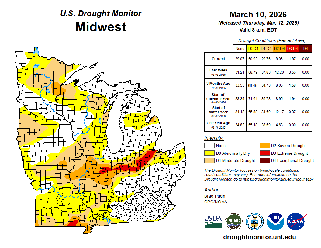
From March 3 to March 10, drought conditions improved across the region (Figure 6). D0 conditions (abnormally dry) improved across Indiana, Iowa, Missouri, and Ohio. D1 conditions (moderate drought) saw the largest improvements—over 8 percent—mainly across Illinois and Missouri. D2 conditions (severe drought) improved across Illinois, western Kentucky, and Missouri. D3 conditions (extreme drought) slightly improved across eastern Illinois and Indiana.
March 10th Severe Weather
Northern Indiana experienced a severe weather outbreak on March 10, producing several tornadoes. The most significant tornado was a long-track EF3 with sustained winds of 150 mph, lasting 36.4 miles on the ground. This tornado caused significant structural damage along its path and resulted in 11 injuries and 3 deaths. An EF1 tornado spent 10 miles on the ground in Jasper County, Indiana, causing damage to homes and resulting in 3 injuries. An EF1 tornado spent over 14 miles on the ground in Starke County, Indiana, with a damage survey indicating that multiple funnels may have caused damage along its path.