March 1-10, 2009
Midwest Weekly Highlights - March 1-10, 2009
Wintry Beginning, A Wild End
The wild swings in weather that are often characteristic of spring in the Midwest were much in evidence the first ten days of March. The month began with low temperatures dropping into the -20s°F in Minnesota, Wisconsin, and Michigan, and record lows being set from Wisconsin to Kentucky. Only five days later record high temperatures were reported from Missouri northeastward into Michigan. Heavy lake-effect snow occurred on March 2, and on March 8 severe thunderstorms and tornadoes occurred from Missouri eastward into Ohio with snow in the upper Midwest. The ten-day period came to an end with heavy rain in the central Midwest and a blizzard across western Minnesota.
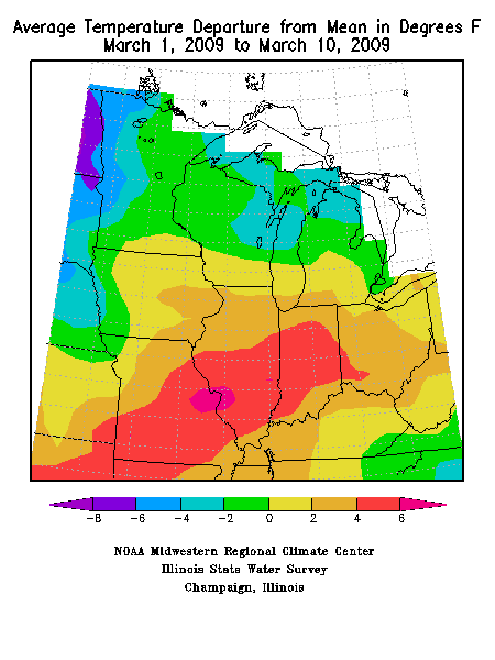
Average daily temperatures ranged from 1°F to 6°F below normal from northern Minnesota eastward across northern lower Michigan (Figure 1). Temperatures were well above normal in the southern two thirds of the region, with a band of +4°F to +6°F departures from southwestern Missouri across the southern half of Illinois and much of Indiana.
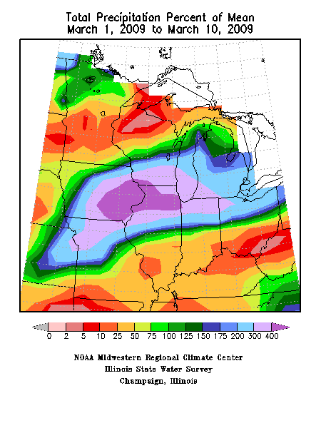
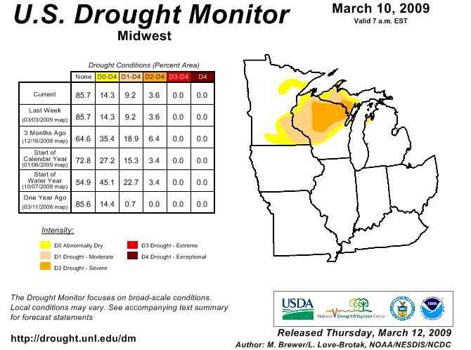
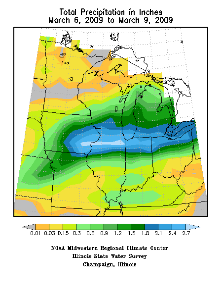
Most of the Midwest received precipitation this week, but far northern and southern portions were on the short end (Figure 2) Precipitation was 200 to more than 400 percent of normal in a wide band across the central Midwest, dropping off to 25 to 50 percent of normal in the Ohio Valley and from southern Minnesota into northern Wisconsin. Most of the precipitation this week missed the dry areas of the upper Midwest, and the March 9 U.S. Drought Monitor showed no change in the drought status in the upper Midwest (Figure 3).
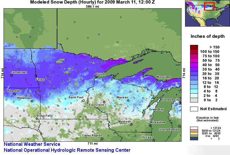
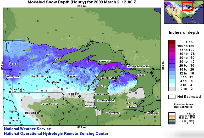
Colder than normal weather and additional snow this week in the upper Midwest maintained a deep snow cover from northern Minnesota eastward into Michigan. Snow depths ranged from 12 to 20 inches in Minnesota to more than 24 inches in the Michigan U. P. (Figure 4).
Frigid Weather
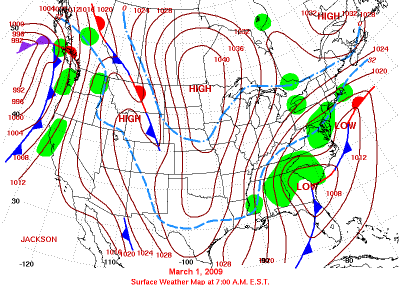
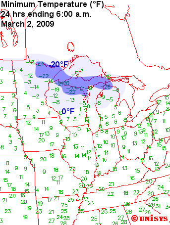
The month began with a massive high pressure system settling over the Midwest, extending from north of Hudson Bay south into Mexico (Figure 5). This high came on the heels of a storm that laid down a swath of 2 to 6 inches of snow from western to southeastern Missouri and a half inch in northern Kentucky. Clear skies, calm winds, and a deep snow cover across Minnesota, Wisconsin, and Michigan (Figure 6) combined to produce strong radiational cooling. Minimum temperatures dropped to well below zero, down to as low as -23°F in northern Wisconsin (Figure 7). Low temperature records were set on March 2 and 3 in the upper Midwest, and March 3 and March 4 in Ohio and Kentucky as the high drifted to the east coast during the week.
Quick Warm up, Then Storms
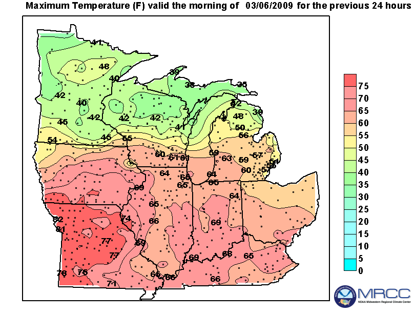
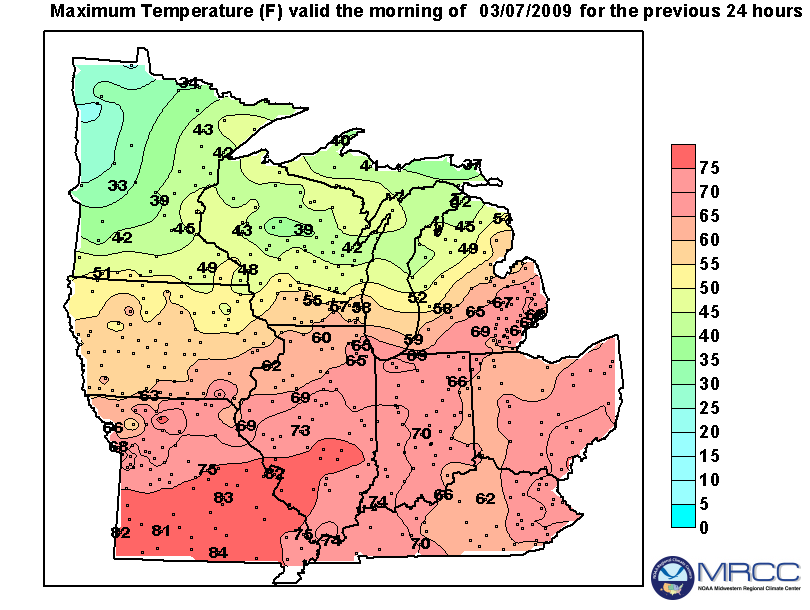
On the morning of March 5 the axis of the ridge extended along the East Coast, and strong southerly winds became established across the Midwest as a low pressure system strengthened in the Central Plains. Temperatures rebounded into the 60s and 70s in the southern half of the Midwest (Figure 8), and on March 6 soared into the low 80s across southern Missouri into south-central Illinois (Figure 9). A handful of record high temperatures were recorded March 5, with many more on March 6 especially across Iowa and Missouri.
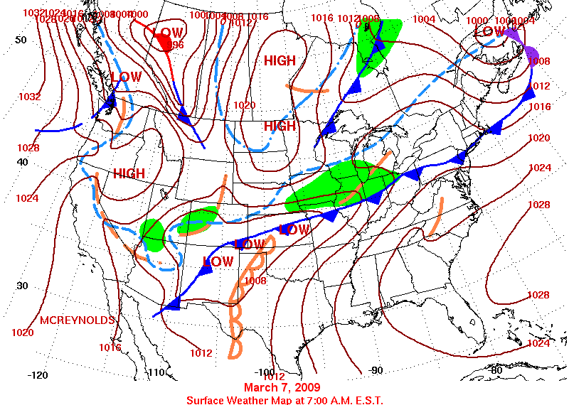
Thunderstorms erupted in northern Missouri on March 6 along a cold front pressing ito the Midwest, with a number of severe storms dropping hail from 1.00 to 1.25 inches in diameter. Scattered severe storms occurred again on March 7 along the cold front which extended from the Rockies eastward through central Indiana and northern Ohio (Figure 10).
Severe storms were more numerous on March 8 from western Missouri to western Ohio as an intense low pressure system developed along the frontal system in eastern Kansas. This was associated with a strong upper level wave moving out of the central Rockies. Much of the central Midwest was in a Moderate Risk for severe weather on March 8. When the day was over, there were 25 reports of tornadoes and numerous wind and hail reports. One EF1 tornado was confirmed in southeastern Missouri, EF1 and EF2 tornadoes were confirmed in Wayne County, IL, and an EF1 tornado was confirmed in Webster County in western Kentucky.
Several tornadoes touched down in western and central Illinois resulting in at least 3 injuries and damage to homes, trees, and power lines. A tornado was confirmed in Macoupin County, IL, and two others reported in Jersey and Randolph counties. An EF1 tornado was confirmed northwest of Springfield in Sangamon County, and just northeast of the Lawrenceville Airport in Lawrence County.
In Indiana, tornadoes were reported in or near Milan (Ripley County), Odon (Daviess County), Fayetteville, Oaktown (Knox County), and Columbia City (Whitely County). In Milan, at least one roof was ripped off a house and there was extensive damage done to power lines along the tornado’s path. In Odon, a family was lucky to survive after their mobile home was severely damaged by the tornado. A local church also suffered minor damage. At least three families ended up in the hospital after a tornado destroyed their homes in Fayetteville. One of the houses was damaged when a school bus was picked up and tossed into it by the strong winds. Debris from the Fayetteville tornado was found in Columbus, two counties and more than 45 miles away. Two tornadoes were confirmed in northeastern Indiana and northwestern Ohio. An EF1 tornado was confirmed in Whitely County, IN near Columbia City. This tornado destroyed three homes and damaged 20 others. An EF0 tornado was also confirmed in Defiance County, OH. No injuries or fatalities occurred with either of these storms. For more detailed information on storm damage and photos of the actual tornadoes, visit the NWS North Webster, IN web site.
Non-thunderstorm winds associated with the strengthening low pressure system lashed the Midwest as the low departed the region. Westerly winds were sustained from 30 to 40 mph with gusts from 50 to 65 mph across parts of Illinois, Indiana, and Kentucky. The winds along with the earlier thunderstorms resulted in thousands of power outages from Missouri to Indiana.
Heavy Rain and Snow
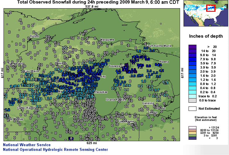
Many parts of the Midwest received heavy rain the last several days of the month, with northern portions of the Midwest receiving another dose of heavy snow (Figure 11).Two to three inches of rain was the rule across the southeastern one-third of Iowa across northern Illinois from March 6-8. In northern portions of Iowa freezing rain and light snow fell, and two people were killed due to an accident on ice-covered roads in Hamilton County on March 8. While the snow was typically two inches or less across northern Iowa, the snow accumulated to a general 6 to 9 inches from south-central Wisconsin through northern Lower Michigan (Figure 12). Amounts to 12 inches or more occurred along the Lake Michigan shore in northern Michigan as winds blowing across the lake enhanced snowfall there.
The heavy rain in Iowa resulted in widespread minor to moderate flooding, with a few locations reporting major flooding. The Iowa River was pouring through a levee break in Wapello, covering a county road and threatening to flood thousands of acres along the river. The heavy precipitation also resulted in rivers and streams going out of their banks in northern Illinois.
Blizzard Conditions, Record Warmth, More Heavy Rain, and Flooding
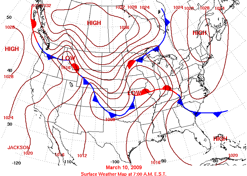
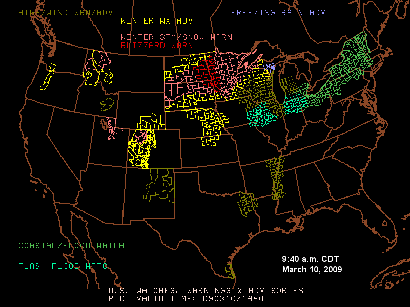
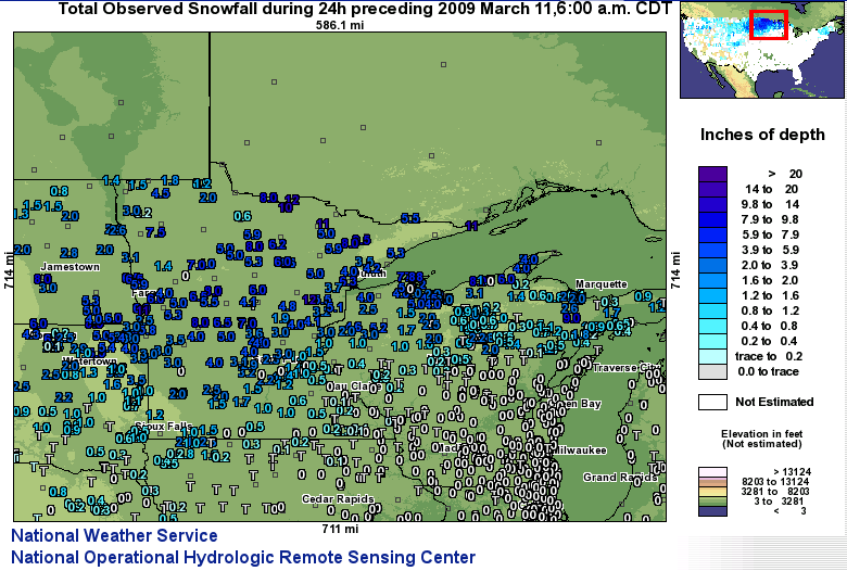
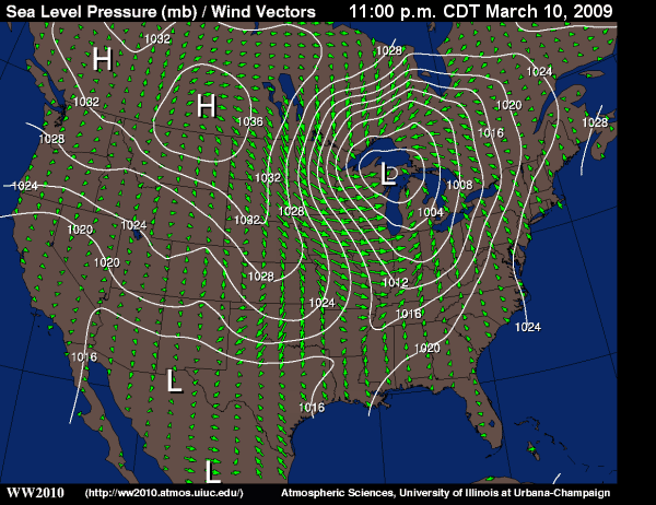
Only 30 hours separated the weekend system from the next. As high pressure was drifting eastward across the Midwest on March 9 the next low pressure system was taking shape over the southern Rockies. The storm, fed by the contrast between a very cold air mass over Canada and warm, humid air streaming northward from the Gulf of Mexico, set the stage for another wild day of weather across the region. On the morning of March 10 the intensifying low pressure center was located over western Missouri, with a warm front extending east through central Indiana (Figure 13). Temperatures reached well into the 70s in the warm sector, and a few record highs were set in southeastern Missouri, Indiana, Kentucky, and Ohio. A shield of rain developed north of the warm front, and heavy rain added to the woes of already waterlogged areas from Iowa eastward to Ohio. A variety of watches, warnings, and advisories were in effect for large portions of the Midwest (Figure 14). By noon on March 10 showers and thunderstorms were moving across the southern half of the Midwest, while a major snowstorm was raging across the eastern Dakotas, Minnesota, northern Wisconsin, and the Michigan U.P. Blizzard warnings were in effect for western Minnesota, and moderate to heavy snow fell across most of Minnesota during the afternoon. Snowfall amounts across northern Minnesota ranged from 4 to 8 inches, with several locations reporting up to 11 inches. International Falls, MN (Koochiching County) reported a 24 hour accumulation of 12.3 inches of snow from the storm (Figure 15).
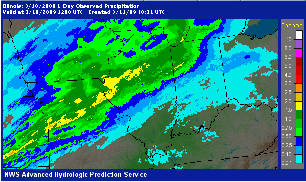
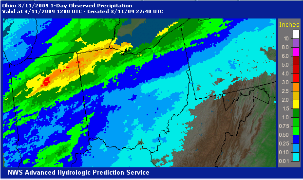
To the south of the wintry weather heavy rain fell once again across eastern Iowa, northern Illinois, northern Indiana, Michigan, and northern Ohio. The heaviest rain from Missouri to Illinois fell overnight March 9 into early March 10 (Figure 16). The heavy shifted east during the day on March 10, soaking northern Indiana, southeastern Michigan, and northern Ohio. Rainfall amounts from north-central Indiana into northwestern Ohio ranged from 2.50 to more than 3.00 inches (Figure 17).
As the strong low pressure system moved across the northern Great Lakes late on March 10 strong west to northwest winds developed across Wisconsin and upper Michigan (Figure 18). Sustained winds of 25 to 35 mph gusted to between 50 and 60 mph. The strongest gusts occurred along the shores of Lake Superior and along the Keewanaw Peninsula (Keewanaw County), with a 70 mph gust recorded at Grand Marais, MN (Cook County).
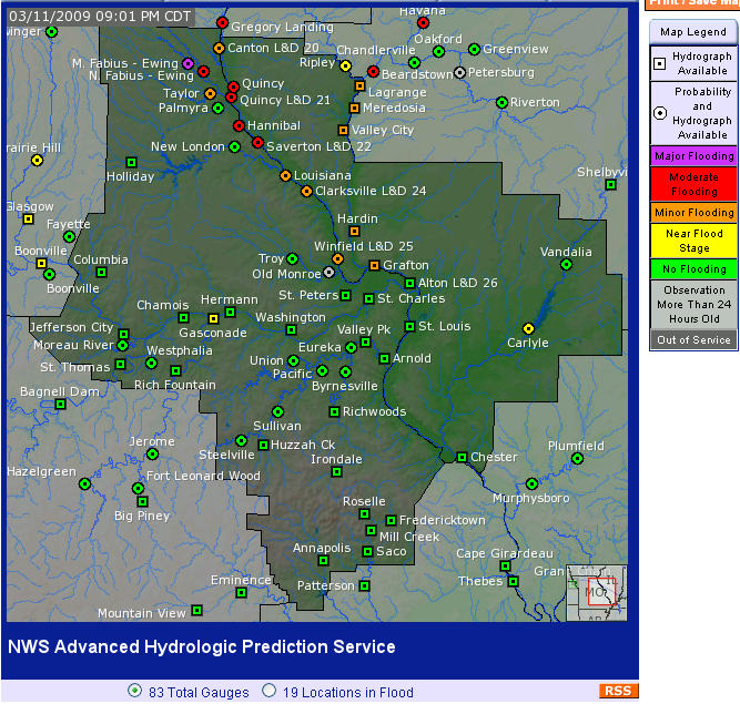
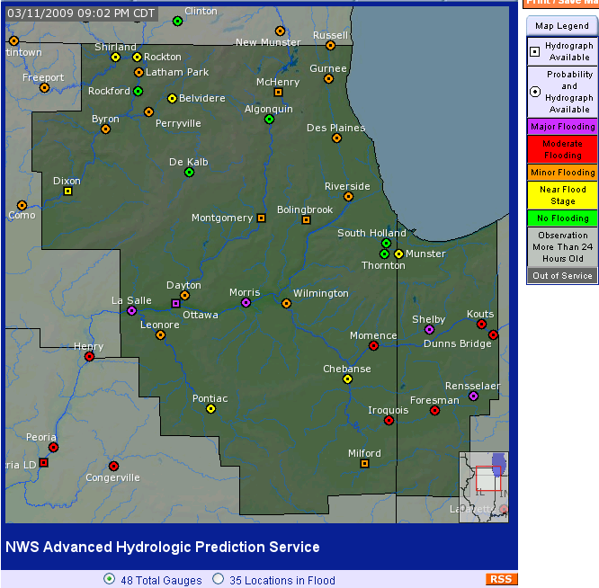
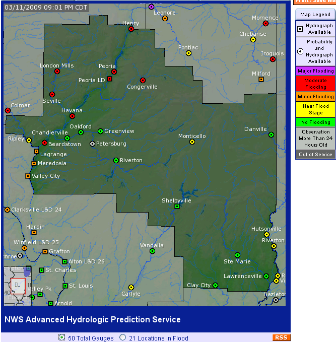
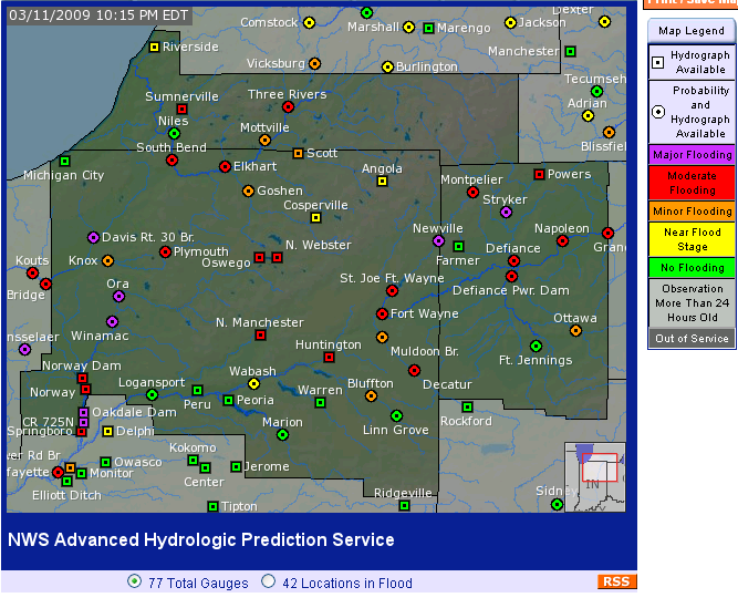
Runoff from the heavy rain during the last four days of this period resulted in flooding on many rivers and streams from Missouri and Iowa eastward southern Wisconsin, northern Illinois, Indiana, western Michigan, and northern Ohio. By late on March 10 a flood warning was in effect for the Mississippi river from Canton, MO south to Chester, IL (Figure 19). Major flooding was occurring on the upper Illinois River (Figure 20), and flood warnings were in effect downstream from La Grange to Hardin, IL (Figure 21). Flooding was occurring on a number of rivers in Indiana, including the Wabash and Tippecanoe Rivers (Figure 22). In White County, Diamond Point and Bluewater developments, along with the Lake Arthur Mobile Home Park, were evacuated because of the threat for major flooding. Residents of more than 55 homes were being put in a shelter at the First Christian Church in Remington. In Fort Wayne (Allen County), citizens were out in full force to help local officials create sandbag and clay walls and install pumps on the evening of March 10th to prevent flooding in neighborhoods near the river.
A number of rivers in western Michigan were above flood stage at the end of the week. The St. Joseph River in Kalamazoo (Kalamazoo County) was out of its banks and several roads were closed due to flooding, including part of the I-94 business loop. The Blanchard River in northwestern Ohio was also in flood, rising at the rate of one inch per hour. Residents of Findlay, OH (Hancock County) were filling sandbags to help keep floodwaters out of the downtown area.