September 10-16, 2008
Midwest Weekly Highlights - September 10-16, 2008
Ike Rakes the Midwest
Hurricane Ike was the big news but by no means the only news in the Midwest this week. While Ike brought heavy rain to an area in broad band extending from Kansas City to southern Michigan, a stalled cold front across the central Midwest and copious tropical moisture resulted in in two days of record-setting heavy rain from Missouri through northern Illinois and southern Michigan preceding Ike's passage. The rain resulted in widespread flash flooding and sent rivers out of their banks. Additional rainfall from Ike only added to the problem. Damaging winds occurred from southern Missouri through Ohio and Kentucky as the low that was Ike raced northeast through the Midwest.
Precipitation for the week was three to seven times normal in Missouri, southern Iowa, the northern three-quarters of Illinois, northern Indiana, southern lower Michigan, and extreme northwestern Ohio (Figure 1). Most of the rain in the central Midwest this week fell from September 12-14. Rainfall amounts exceeded 10 inches in northern Illinois, northwestern indiana, and southwestern Michigan (Figure 2). Rainfall records were shattered across much of this area, and at mid-month precipitation across the central Midwest is already two to four times the normal monthly rainfall for September. In contrast, dry conditions persisted throughout Kentucky where rainfall was less than 25 percent of normal across much of the state. The September 16 U.S. Drought Monitor depicted an expansion of Moderate (D1) drought over Wisconsin and Minnesota, while the rainfall this week brought relief to northeastern Indiana and northern Ohio (Figure 3).
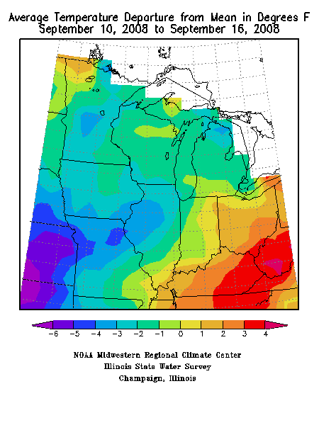
The temperature departures this week reflected the general weather pattern. North and west of the Ohio River, where clouds and precipitation were dominant, temperature departures ranged from 1°F to 4°F below normal (Figure 4). Temperature departures across Ohio south through Kentucky ranged from 1°F to more than 3°F above normal.
Quiet Start, then Torrential Rain
A large high pressure system brought pleasant fall weather to most of the Midwest the first two days of the week. As it retreated to the east, a low pressure system in the northern plains brought scattered showers and thunderstorms to Iowa and Minnesota.
By the morning of September 12 a cold front extended from the northern tip of Lake Huron southwestward to the Texas Panhandle. Moisture-laden tropical air pumped northward by the circulation of Hurricane Ike and the large high pressure system covering the eastern United States streamed over the frontal boundary. A large area of heavy rain developed from central Kansas through northern Missouri, southeastern Iowa, northern Illinois, and southern Michigan (Figure 5). The rain continued unabated through September 13 as this front remained parked over the central Midwest, though it did lessen in intensity during the day.
Ike Adds to Woes
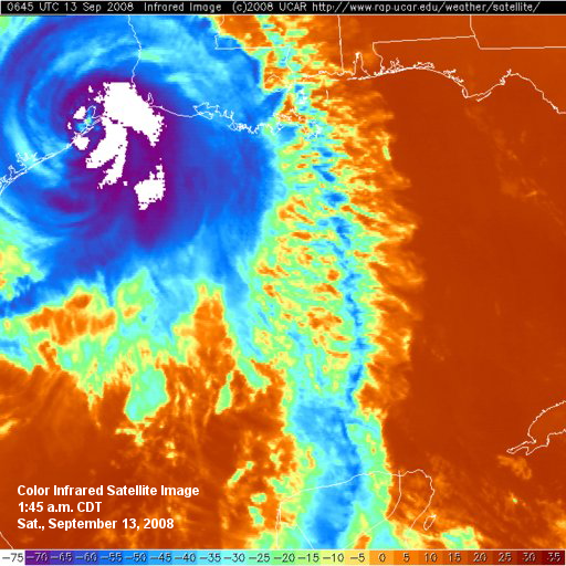
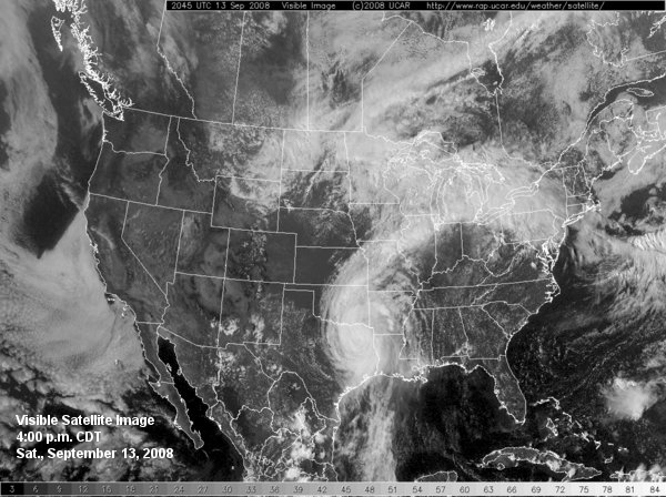
Hurricane Ike slammed into the Texas coast during the early morning hours of September 13 (Figure 6), and continued steadily northward through eastern Texas during the day (Figure 7). Flash flood and flood watches and warnings from Missouri into southern Michigan in anticipation of additional heavy rain from Ike (Figure 8). The remnants of Ike, it's circulation still clearly evident on both satellite and radar, merged with the cold front in northwestern Arkansas during the early morning hours of September 14 (Figure 9). Heavy rain spread across southwestern and central Missouri, then into southeastern Iowa and the northern two-thirds of Illinois as the system moved rapidly to the northeast (Figure 10). The low moved through Missouri by 8:00 a.m. CDT (Figure 11), then to central Indiana by early afternoon, moving northeastward at 50-55 mph (Figure 12).The strong pressure gradient (large change in pressure with distance) between the low and high pressure over the eastern United States produced a band of strong, damaging winds along and south of the low's path (Figure 13). Winds gusted to between 50 and 60 mph, with a gust to 75 mph reported at Port Columbus International Airport (Franklin County, OH) and an unofficial gust of 84 mph recorded in West Chester, OH (Butler County). The winds continued for several hours during the afternoon across Indiana, Ohio, and Kentucky. By midnight, the low pressure system that had been Hurricane Ike 36 hours earlier was moving into southern Quebec, Canada (Figure 14).
Impacts - Rain and Wind
Although most of the severe weather was related to the heavy rain and the strong winds generated by the low pressure system as it moved through the Midwest, a number of tornadoes were reported in Missouri on September 11 and September 12. On September 11 at least two tornadoes were reported in southern Missouri, and on September 12 tornadoes were confirmed in the Kansas City area and in north-central Missouri, with some structural damage. On September 13 three tornadoes touched down in Michigan. One briefly touched down near Paw Paw in Van Buren County. A second tornado was on the ground for one-half mile near Westwood, MI (Kalamazoo County) damaging numerous trees. The third tornado was sighted near Brookfield, MI (Eaton County) and caused some minor damage.