June 10-16, 2008
Midwest Weekly Highlights - June 10-16, 2008
More Rain
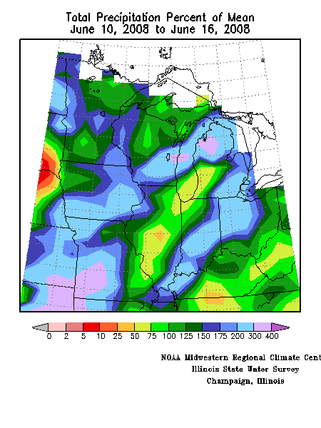
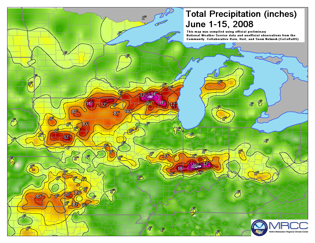
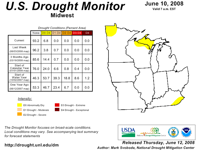
Record flooding was occurring in the Midwest in the wake of more heavy rain during the second week. Precipitation was 200 to more than 300 percent of normal over the western half of Missouri, across southern and eastern Iowa, southern Wisconsin, and northern lower Michigan (Figure 1). Rain was also 200 percent of normal from southern Illinois northeastward through southern Indiana and into the northwestern half of Ohio. Through the first half of June, more than 14 inches of rain has accumulated in parts of Iowa, Wisconsin, and Indiana (Figure 2). Higher than normal rainfall in Minnesota improved dry conditions in the northwest part of the state where there was a one-category improvement in the June U.S. Drought Monitor (Figure 3).
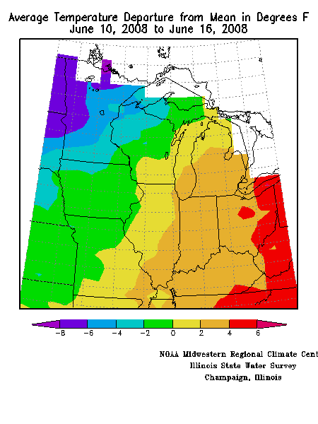
The was a large difference in average daily temperature departures across the region, with very warm weather in the southeast and much cooler than normal weather in the northwest. Departures ranged from 4°F to 5°F above normal in much of Ohio to 4°F to 8°F below normal in Minnesota (Figure 4).
Iowa Thunderstorms Compound the Misery
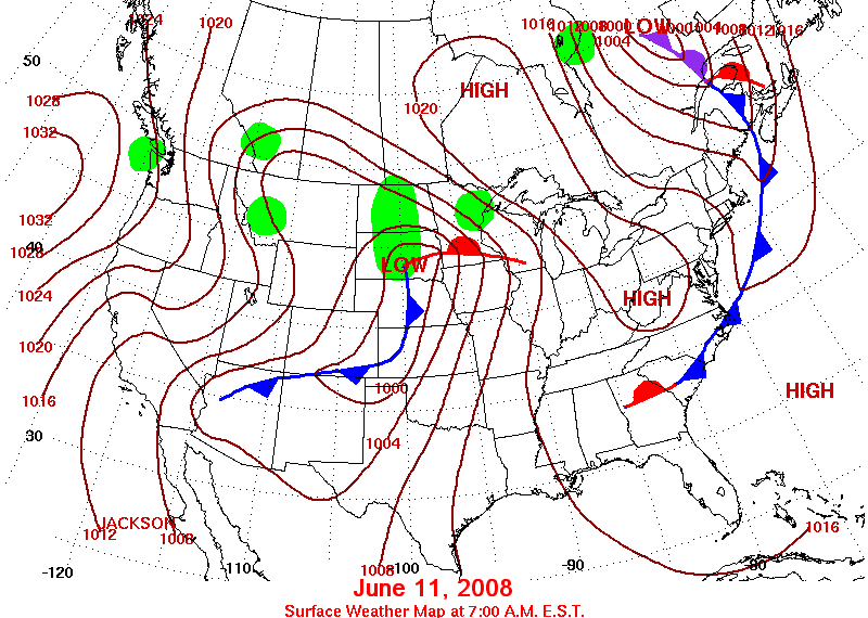
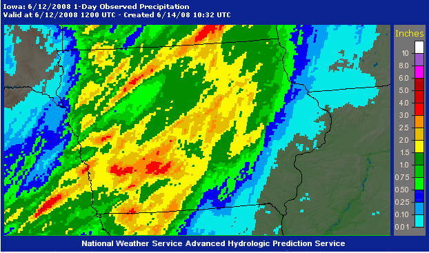
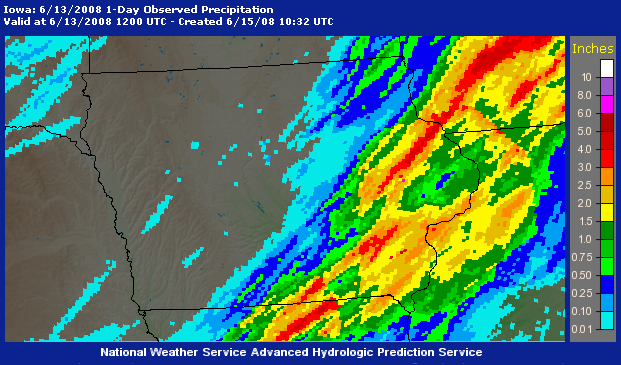
A strong low pressure system over the northern Plains re-ignited severe thunderstorms over the central Plains and Midwest late on June 11 and through June 12 (Figure 5). From late afternoon through the pre-midnight hours on June 11 there were 64 reports of tornadoes in a concentrated area from central Kansas through western Iowa and into southern Minnesota. This included one tornado that directly hit a Boy Scout camp near Blencoe, IA (Monona County) at 6:35 p.m. CDT, killing four scouts and injuring at least 40 others. The storms moved eastward (Figure 6), eventually dying out in the early morning hours. Two to four inches of rain fell from southwestern into central Iowa with these storms (Figure 7). The advancing front and unstable atmosphere fired up more thunderstorms by the early afternoon hours of June 12, with numerous reports of severe weather from southern Kansas into northern lower Michigan. These storms dumped more heavy rain on eastern Iowa, with more than two inches in some locations (Figure 8).
Flooding in Southwest Missouri, Michigan
Thunderstorms ahead of the front in southwestern Missouri on June caused significant flooding (Figure 9). Rainfall across from central Lawrence County through Greene County and central Webster County ranged from 3.25 to more than 5.50 inches (Figure 10). A number of locations reported record daily rainfall. Springfield, MO received 3.88 inches, breaking the old record for the date of 2.00 inches set in 2004. The flash flooding of Galloway Creek in Springfield significantly damaged Galloway Village, a historic section of specialty and antique shops. Water levels reached three feet in just an hour. Flood waters also washed away tons of rock from the railroad line to the James River Power Plant, interrupting coal shipments until workers could finish replacing it several days later.
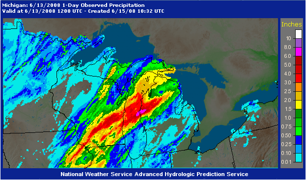
Thunderstorms also flooded parts of western Michigan June 12 and early on June 13 (Figure 11). An unofficial rainfall report of 11 inches in less than 12 hours was made in Scottville, MI (Mason County). The rain caused the Pere Marquette River to flood, and on June 15 was still almost five feet above flood state. Flooding closed 29 roads in Mason County, and a sewage main that served about 90 percent of the population of Ludington, MI (Mason County) ruptured. Approximately 12,000 utility customers in southern Michigan were without power as a result of the storms.
More Severe Weather, Then Calm
Another cold front pressed south into the Midwest on June 15 and the area was primed for more severe weather. Thunderstorms fired up along and ahead of the front during the afternoon and evening, and there were many reports of damaging winds and hail across the central Midwest. Most damage was relatively minor, although morning thunderstorms knocked out power to an estimated 140,000 customers in the Chicago area. There was one report of 2.0 inch (baseball-size) hail near Mishawaka, IN (St. Joseph County), which dented and broke windows on numerous vehicles.
This period ended quietly for most of the region with sunny skies and pleasantly warm weather. Thunderstorms moved through northern Kentucky and southern Ohio ahead of the advancing cold front on June 16, but there were only a few severe storms producing 3/4 inch hail.
Flooding Impacts
Impacts from the flooding caused by frequent and heavy rain the first half of June continued to mount. The largest impacts were in Iowa, where most of the tributaries to the Mississippi River in eastern Iowa reached record flood stages, surpassing even those set during the Great Flood of 1993. The flooding was having major impacts on agriculture In addition to inundated fields. On June 16 corn priced at the Chicago Board of Trade rose above $8 a bushel on news that as many as 3 million acres of corn were under water and another 2 million weren't planted, for an estimated 700 million bushels of corn. Crop insurance companies potentially could suffer big losses, despite the increase in insurance premiums in recent years. Premiums paid in Iowa and Illinois, the biggest corn-producing states, account for about one fifth of the nation's total Iowa and Illinois, and about 25 percent of potential losses.
Shippers have also been severely impacted as roads and bridges have been washed out, and high river levels put barge traffic on hold. On June 16 the president of one barge line estimated that losses to the industry could rise about $1 million a day. Locks 13-25 on the Mississippi River were still closed, leaving 281 miles of the river closed to commercial traffic. Major rail lines in Iowa, Wisconsin, Minnesota, Missouri and Illinois have been washed out. Customers have been told to expect delays in their shipments ranging from a few days to indefinitely.
ILLINOIS
June 16 flood status:
Southeastern Illinois
On June 10, Illinois issued a state disaster declaration for six southeastern counties (Clark, Coles, Crawford, Cumberland, Jasper, and Lawrence) after heavy rains in May and June caused levees along the Embarras and Wabash rivers to fail. Some 200 homes were evacuated in the area around Lawrenceville. Floodwaters temporarily knocked out the water supply to Lawrenceville, affecting roughly 10,000 people. On June 15, water service was restored after divers repaired a broken water main that was located under floodwaters. Douglas County was added to the state disaster area list on June 14.
Northern Illinois
In Lake County, the Fox River has been the source of ongoing flooding, especially along the Chain O'Lakes in the northwest suburbs of Chicago. For safety reasons, the Illinois Department of Natural Resources began restricting boating access to the Fox River in on June 9. On June 16 one boater, ignoring the restrictions, died after falling into the flood-swollen Fox River near Stratton Dam near McHenry (McHenry County).
The Pecatonica and Rock rivers were both reported above flood stage this week. An estimated 500 people were affected by the floodwaters in some way in Rockford (Winnebago County) and surrounding communities. In Moline (Rock Island County), the Rock River crested at 14.9 feet on June 16. Low-lying areas in Moline were impacted by the flooding.
Western Illinois (along the Mississippi)
While Illinois escaped the heaviest rains of Iowa and Wisconsin in early June and the immediate flooding, Illinois residents along the Mississippi River have had deal the rising flood waters this week. A slow moving crest of water is moving down the Mississippi River, impacting communities down to St. Louis. Keithsburg, a small town of 700 residents in Mercer County, was partially evacuated after nearby levees failed on June 14. Parts of the town are under 3 to 5 feet of water.
Other towns and cities along the Illinois side of the Mississippi River prepared for rising waters that were expected to crest later in the week. The state of Illinois declared several counties on the river as disaster areas in anticipation of upcoming flooding. By June 16, more than 400 Illinois National Guard troops and 220 inmates were deployed in operations in western Illinois. To date, the State of Illinois has deployed more than 2.8 million sandbags, and is prepared to provide at least another 4.5 million sandbags within the next few days to help communities shore up vital levees. The Illinois Emergency Management Agency (IEMA) has assigned Incident Management Teams to Adams, Henderson, Mercer and Pike counties, as well as to the Unified Area Command in Quincy (Adams County), to help local emergency managers develop plans for addressing crucial flood-related issues.
The US Army Corp of Engineers (Rock Island District) reported that the Niota, Hunt-Lima, Indian Grave, and portions of the Sny levees had a high potential for overtopping, based on forecasted crest stages by the NWS on June 15. The Henderson levees in Henderson County have already been overtopped.
Levee Overtopping Potential Map from Rock Island District, Army Corps of Engineers
INDIANA
June 16 flood status:
June 10 - A Ball State University report made a very preliminary damage estimate of $126 million from flooding on the White and Wabash Rivers, with $45.8 million in damages to public infrastructure.
Major flood damage closed Columbus Regional Hospital in Bartholomew County.
A levee break on the White River damaged at least 55 homes in Daviess County and prompted evacuations around Maysville and Washington.
The water system in Jasonville (Greene County) was out of commission for five days when flooding broke the main water line. Ninety buildings suffered damage. Railroad tracks west of Bloomfield were pushed off of the roadbed, and a bridge on Indiana Highway 57 washed away.
800 buildings in Johnson County were destroyed by flooding. The worst damage occurred in the southern part of the county in Franklin and Prince Lakes.
Duke Energy shut down its power plant in Edwardsport ( 160 homes in Martinsville (Morgan County) were reported destroyed, and another 1,500 damaged. 600 homes were damaged by flooding in Levee Overtopping Potential Map from Rock Island District, Army Corps of Engineers Photos of Iowa flooding can be viewed at the Iowa Department of Transportation web site. MINNESOTA June 16 flood status: June 11 - Floodwaters from the Cedar River near Austin, MN (Mower County) closed part of Interstate 90 June 12 - A man was killed in Freeborn County when he drove off a washed out road into floodwaters. Another man whose vehicle had gone off of the road and landed on the other vehicle was above to escape unhurt. WISCONSIN June 16 flood status:
Flooding continued in southern Wisconsin after severe weather and heavy rains again struck the area on June 12 and June 14. Numerous roads were closed across the region, including several major routes. The westbound lanes of Interstate-94 between Milwaukee and Madison were shut down when the Rock and Crawfish Rivers threatened the roadway. North of Madison, I-94 westbound was closed to Mauston due to rising water on the Baraboo River. In addition to the interstate closures, countless state and county roads have been damaged or shut down. In Sauk County alone, officials stated that about 95 percent of the county’s roads have suffered some damage and several bridges have been destroyed. Before the storms came again on June 12th, 234,000 sandbags had been distributed and placed according to Wisconsin Emergency Management officials and 200,000 more were on order. Of the original number, nearly half went to help flooding in Sauk County. After the destruction of Lake Delton there earlier in the month, flooding continued to impact tourism to that area with the closure of the Circus World Museum in Baraboo. Original Wisconsin Ducks and Dells Army Ducks, World War II amphibious vehicles used to tour in the Wisconsin Dells and on the Wisconsin River, were used to evacuate threatened homes and businesses in Baraboo. Eleven vehicles were used to make more than a dozen rescue missions and brought more than 100 people to safety. The Ducks were also used to help remove debris from the Dell Creek Dam so that it would not clog and due to their efforts the dam remained intact. Devil’s Lake State Park in Sauk County remains closed because of flood damage to the park’s infrastructure, including road and hiking trail wash outs and inoperable toilets and showers at the 10,200-acre park. Other state facilities closed include Wildcat Mountain (Vernon County) and Rocky Arbor State Parks (Juneau/Sauk counties) and Elroy-Sparta and “400” State Trails. In southwestern Wisconsin, flooding destroyed three homes in Potosi (Grant County) and prompted a voluntary evacuation of the community of Avoca (Iowa County). For the town of Gays Mills (Crawford County) on the flooded Kickapoo River, this was the second major flooding event in a year. The town was still rebuilding from the floods in August 2007 that damaged 70 homes when this month’s storms struck. The Kickapoo River crested at more than 7 feet above flood stage and matched a record last reached in 1978. The town is now in discussions about relocating the community to higher ground.