October 1-10, 2007
Midwest Weekly Highlights - October 1-10, 2007
Record Start to October
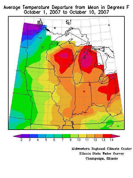
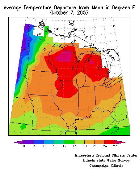
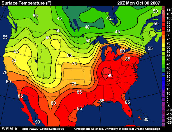
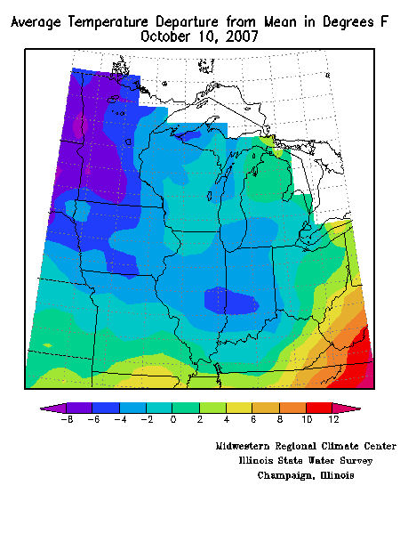
The first part of October 2007 saw hundreds of daily high maximum and high minimum temperature records fall as the Midwest sweltered through a late season heat wave. The average temperature for the entire Midwest during October 1st to the10th was warmer than normal (Figure 1) and during the peak of the heat the average daily temperature was running at almost 30 degrees above normal for a large portion of the region (Figure 2).
In addition to the heat, many areas also suffered under abnormally dry conditions (Figure 3). Portions of Kentucky, Indiana and Ohio were at only 20% or less of their normal precipitation during the first ten days of the month. In contrast, areas of Minnesota, Iowa, Wisconsin and Missouri were at almost 500% of normal.
Hot! Hot! Hot!
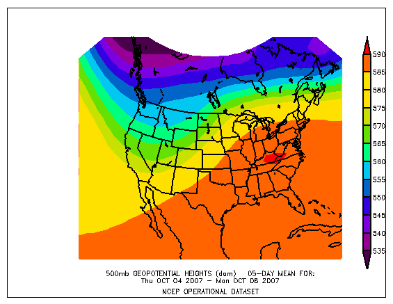
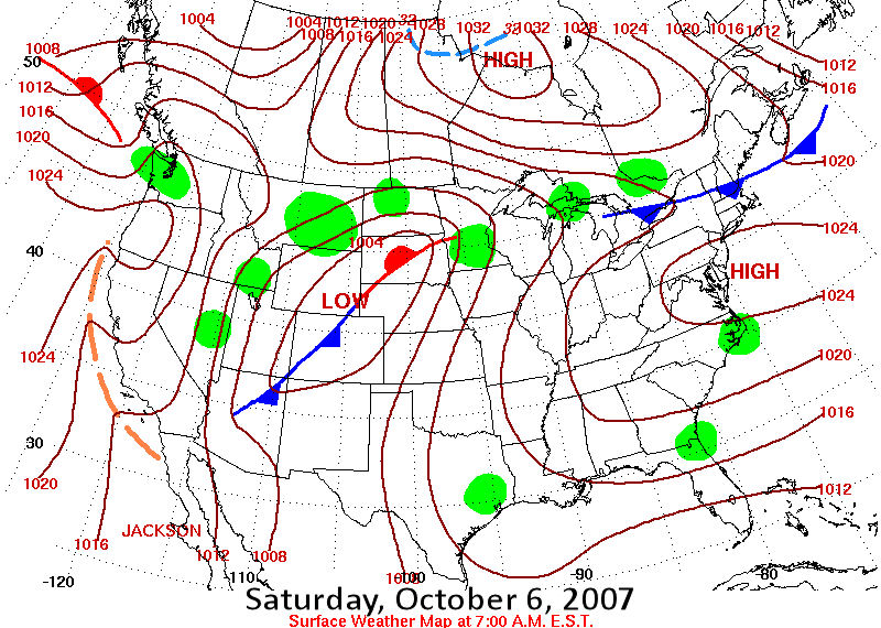
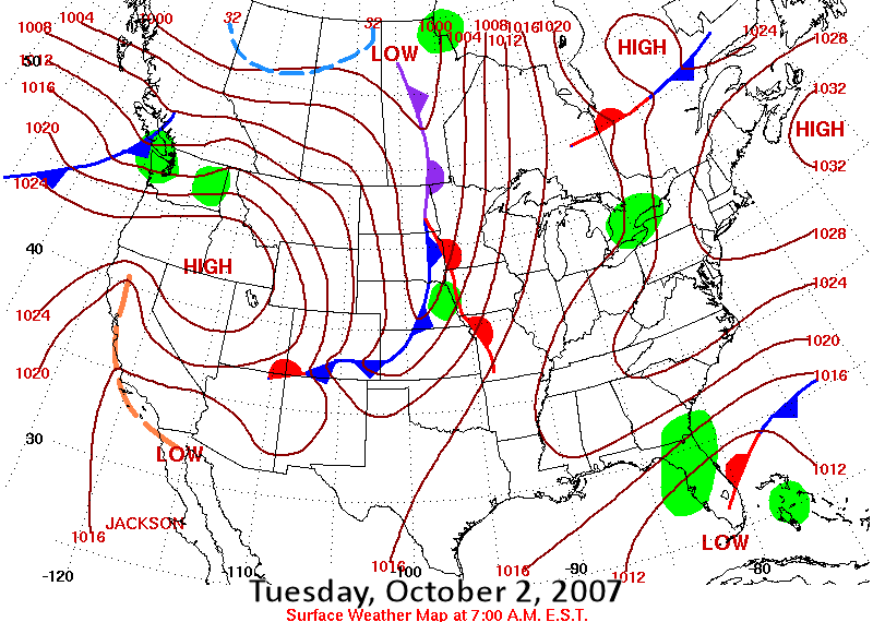
The record heat from the 4th to the 8th was triggered by a persistent and unseasonably strong ridge of high pressure in the upper atmosphere (Figure 4). And with the combination of a strong high pressure system off the east coast and a low to the west (Figure 5), winds at both the surface and aloft were from the south, surging the warm and humid air mass into our area. With the increased humidity, nighttime temperatures didn't drop far from the daytime highs and impressive record high minimum temperatures also resulted.
Apart from the daily records already mentioned, numerous monthly or station records were also set. Alpena, MI; Columbus, OH; Gaylord, MI; Indianapolis, IN; Louisville, KY and Saginaw, MI all saw their highest October temperature on record occur on October 7th or 8th. And with highs in the upper 80's and 90's on Monday, October 8th, several stations across Indiana reported their latest date for such warmth to occur - South Bend, Indianapolis, Fort Wayne (Figure 6). The 8th also had areas as diverse as Saginaw, MI, and London, KY, reporting their latest 90 degree day. In Lafayette, IN, the mean temperature for the first nine days of the month was actually greater than the average high temperature for the same period.
Heat impacts were felt across the region as events scheduled to take place in fall-like conditions occurred in an environment more reminiscent of July. In Indianapolis, the heat and humidity overcame three dozen participants in a high school marching band competition, while in Chicago, the Chicago Marathon organizers halted the race after three and one-half hours over concerns about heat exhaustion. On this, the 30th anniversary of the running of the race, hundreds of the 35,000 race participants had to be treated for heat related illnesses as temperatures climbed to a record 87 degrees Fahrenheit within hours of the start.
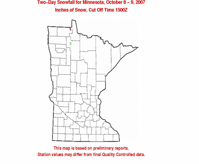
A break finally occurred at the end of the first week of October when a frontal boundary passed through the Midwest and filtered in much cooler temperatures (Figure 7). In fact, this frontal passage on October 8th brought the first snows to northern Minnesota for the year with up to two inches accumulating in some grassy areas (Figure 8).
Persistent Drought
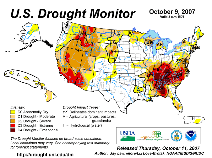
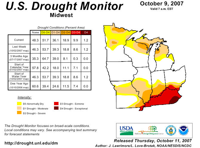
With the combination of record warmth and little to no precipitation, drought conditions in Kentucky continue to be a serious concern (Figure 9). With almost all of Kentucky in extreme or exceptional drought (Figure 10), Governor Ernie Fletcher signed an executive order on October 4th banning all outdoor burning throughout the state, expanding the previous isolated burning bans enacted by 32 counties. The official fire season for Kentucky began on 10/1 and runs through 12/15, and already numerous fires are occurring in eastern Kentucky, including several larger fires (Figure 11). Because of the drought, wildfires are burning faster and hotter and causing more damage than in previous years. In some cases, fires that are initially contained by fire lines are spreading by burning through dried roots. Older trees, that normally would be large enough to avoid serious damage, are so dry that they too are destroyed. Fires in Kentucky are a concern for both the state's tourism industry and the timber industry as a fire damaged tree can lose up to 75% of its value. In neighboring Indiana, the Hoosier National Forest has also enacted a burning ban for all of its National Forest property.
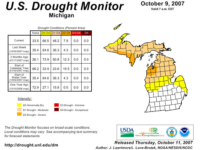
To the north, much of Wisconsin and Michigan have received rain during the start of the month, but the northern half of Michigan remains dry. This dryness, coupled with the record heat, has led to a worsening of drought conditions along the Lake Michigan shoreline and to the east toward Alpena (Figure 12).
Another drought impact may become more seasonably noticeable as we move into October. Portions of the top five pumpkin producing states (Illinois, Pennsylvania, Ohio, New York and California) experienced excessive heat and/or drought this summer, damaging their crops. Much to the dismay of children, the heat was hardest on the larger jack-o-lantern style pumpkins and so they may be more scarce or expensive this Halloween. Carvers beware!
Harvest Time
With the dry and warm conditions across much of the Midwest, there has been rapid harvest progress in many states. In Michigan, estimates are for the harvest to be done several weeks early, while in Illinois, the 76% of the corn harvested is the highest percentage harvested by October 7th in the past 10 years (ranging from a low of 39% in 2002 to a previous maximum of 61% in 2004). Because of the rapid pace, some grain elevators are running at full capacity and may have to start limiting deliveries.
Farmers in southern Minnesota experienced delays in harvesting due to standing water in fields as rains early in October followed on the heels of heavy rains at the end of September. In Owatonna (Steele County), the last weekend of September brought five to six inches of precipitation followed by an additional inch on Tuesday, October 2nd, when a cold front pushed through the area. In other portions of central and south central Minnesota, saturated soils led to lowland flooding. Near Trenton Lake in Hartland (Freeborn County), there was a report of corn standing in water 1 foot deep while elsewhere in Hartland was a report of a combine sitting out in field in two feet of water.
In neighboring Iowa, the harvest was also delayed by rains both early and late in the Climate Watch period and some low areas in the eastern part of the state are under water. However, the warm days and moist conditions have aided pasture conditions. Wisconsin farmers also have experienced some harvest delays from rains early in the month but again reaped later benefits as the warm humid conditions accelerated the emergence of the winter wheat crop.
In contrast to the wet conditions in the northwest Midwest, nine of the last ten weeks in Kentucky have been above average in temperature and below average in precipitation, resulting in both topsoil and subsoil moisture levels at 95% short or very short. Agricultural losses to this drought have been so severe that on October 2nd, Acting Agricultural Secretary Charles Conner issued a natural disaster declaration - making low-interest Farm Service Agency loans available to farmers in the state.
Flooding in Minnesota and Iowa
In addition to the harvest delays mentioned above, the heavy rains that fell at the end of September and into October caused flooding in some areas of southeastern Minnesota. In Dodge County, near the town of West Concord, where three inches of rain fell over two hours from September 30th into October 1st, water washed over County Road 24 and left some motorists stranded. Several other roads to the west and northwest of town were washed out. Flooding also affected the Middle Fork Zumbro River and Milliken Creek where fields nearby had two to three feet of water running through them and some people had to be evacuated from their farms. A bridge on County Road 7 was acting as dam and caused water to back up on west side of the span. In neighboring Steele County, rain fell at a rate of two inches per hour with radar estimated totals of three to five inches and storm sewers backed up into 40 homes in Owatonna, MN. Additional rain fell in southeast Minnesota on October 3rd and caused further flooding in Dodge and Goodhue counties.
On Sunday, October 7th, a cold front and upper level disturbance moved across the Midwest triggering heavy storms in Iowa. In eastern Iowa, rural roads were closed and streets and basements were flooded in the wake of highly concentrated thunderstorms that dropped up to six inches of precipitation in areas of Clayton and Delaware counties. Floodwaters from the Maquoketa River and its tributaries overflowed low-lying streets and left some cars completely submerged in Manchester, IA (Delaware County) when three inches of precipitation fell in just one hour. In Clayton County, Bear and Elk Creeks were also out of their banks. The storm total for Manchester as reported by the Community Collaborative Rain, Hail and Snow Network was 5.33 inches and to the north, Edgewood, IA (Clayton/Delaware Counties) reported 5.21 inches of precipitation. These 6-hour storm totals are more than twice the average October monthly precipitation total. For further information on this system, please see the La Crosse, WI and Quad Cities, IA/IL National Weather Service Weather Forecast Office write-ups.
Late Season Tornadoes
Severe weather struck portions of Iowa, Missouri, Wisconsin and Illinois on Tuesday, October 2nd as supercell thunderstorms formed ahead of a cold front that moved across the region that evening and overnight (Figure 13). In Iowa, an EF-1 (Enhanced Fujita Scale) tornado struck downtown Des Moines (Polk County) at 4:40 p.m. National Weather Service reports indicate that it was a smaller tornado with only an 8 block path length. However, with winds at the upper end of the EF-1 range (110 miles per hour) for a brief duration, it was able to move several vehicles about, including dropping one SUV on its nose and sliding it for approximately 30 feet. The last time a tornado struck the city of Des Moines was in May 2000 when an F-1 tornado hit the northeast section of the city before traveling northeast to Altoona. Additional vehicular and structural damage was reported at a parking lot at the Des Moines International Airport, however a National Weather Service storm survey indicated that this damage was from an intense microburst and not a tornado. Elsewhere in Iowa, an EF-1 tornado two miles east of Delta (Keokuk County) destroyed a cattle barn and machine shed The winds, estimated at 100 miles per hour, lofted a three ton horse trailer and rolled it 200 feet. Two houses were also hit with one sustaining moderate damage and the other minor damage. In Seymour, IA (Wayne County), another EF-1 tornado with winds of approximately 95 miles per hour blew through town. The path was very narrow and intermittent. Storm reports included damage to a farm shed and windows blown out of a church.
To the south in Missouri, numerous tornadoes were also spawned by the same system that struck Iowa. At Lake Show-Me in Memphis, MO (Scotland County), two campers were destroyed when one camper was hurled several yards before collapsing and the other was turned upside down before coming to rest on its roof next to a nearby power pole. The tornado then traveled to the northeast, damaging power poles and trees before striking the Scotland County Fairgrounds at approximately 4:30 p.m. An outbuilding was destroyed and the art hall, cattle barn and sheep barn all sustained roof damage. The tornado was rated as an EF-1 with wind speeds estimated at 92 miles per hour. At approximately 4:45 p.m., an EF-2 tornado struck Monroe County, starting near the town of Woodlawn, MO and ending near the town of Hunnewell for a path length of almost 16 miles (although the tornado was not on the ground the entire time). Near Woodlawn, a tree with a five foot diameter trunk was twisted and snapped off five feet above the ground and a residence had half of its roof blown off. Later in the tornado's path, it completely destroyed a barn before slamming into a single wide mobile home and blowing it down a hill, critically injuring its 85 year old inhabitant. In addition to the tornado damage in the county, several structures sustained damage from downbursts including a farmstead that had a chimney wrecked by straight line winds of 60 to 80 miles per hour. Three other tornadoes associated with a high precipitation supercell thunderstorm were confirmed in and around the town of Palmyra in Marion County at approximately 5:30 p.m. The northernmost track (EF-0) hit the town of Palmyra and caused tree and power line damage and blew the roof off the Ben Franklin Store on Main Street. The second tornado (EF-1) started approximately four miles southwest of Palmyra and travelled to the northeast. It caused significant damage to three of four large corrugated steel buildings at the Consolidated Machine and Welding Company. The structures had roof damage, sidewalls gone, overhead doors sucked right off of their tracks and windows blown out. A semi trailer was lifted and dropped onto two other semis. As the tornado continued on, it then struck the Mission Hills Baptist Church just minutes after all children had been picked up from the church's daycare. The church, which had just recently completed construction, had roof and window damage. The third tornado (EF-0) had a short path and narrow width and struck to the southeast of town. For details on the severe weather on October 2nd in northeast Missouri, please see the St. Louis National Weather Service's web site.