October 1-10, 2006
Midwest Weekly Highlights - October 1-10, 2006
October Begins with Return to Late Summer Pattern
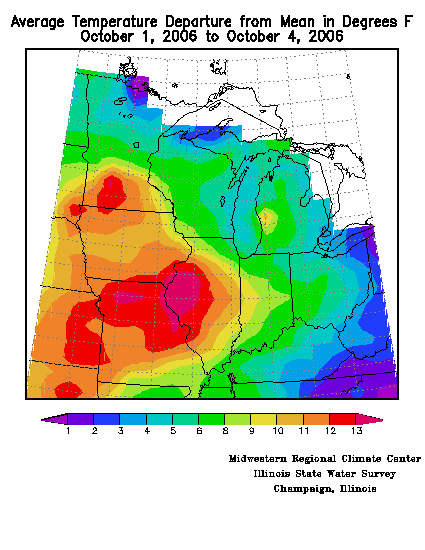
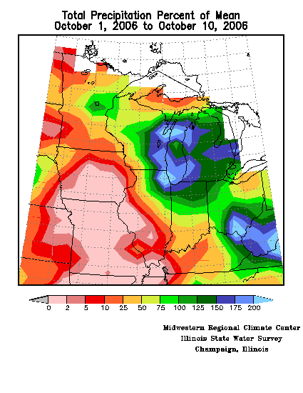
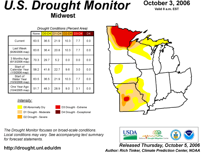
A late summer-like weather pattern brought record high temperatures to the western and central Midwest and severe weather to the northern portions of the region the first few daysof October. Although cooler air eventually returned to the region late in the week, temperatures for the first ten days of the month ranged from 5-8°F above normal across western Illinois, much of Iowa, and a good portion of Missouri, to just 2-5°F above normal across the eastern Midwest, including Ohio, Indiana, Kentucky, and Michigan (Figure 1). The first four days of the period were extremly warm, with temperatures averaging 2°F above normal in eastern Ohio to 10°F to 13°F above normal for much of the region west of the Mississippi River (Figure 2). An upper level ridge over the Midwest kept the majority of the storms over the northeastern portions of the region. Heavier rains fell across Lake Michigan eastward into lower Michigan and parts of Ohio, where up to 200% of normal precipitation fell this week. Remarkably, precipitation was extremely sparse across Missouri, Iowa, and southern Minnesota, where weekly totals were less than 5% of normal for this time of year (Figure 3).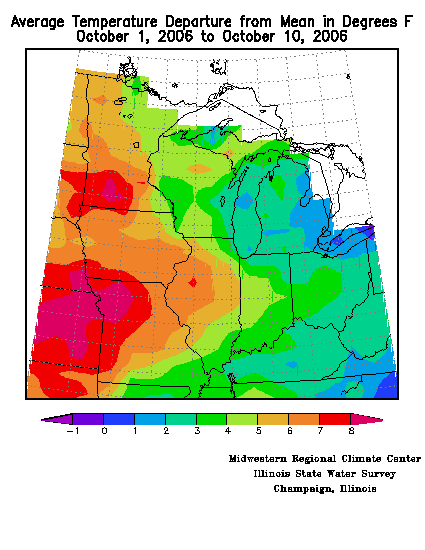
Hot Times in
the Midwest
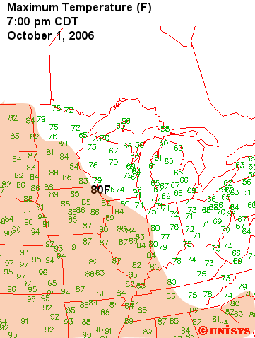
An upper level ridge building into the
Midwest the first three days of October resulted in numerous record
high temperautres across the western Midwest. On October 1
much of the southwestern half of the region was basking in 80°F
weather, with highs of 90°F and above being recorded in western
Missouri (Figure
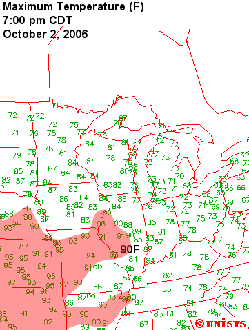
4). The heat spread further east on October
2, with maximum temperatures in the 90s occurring as far east as
western Illinois (Figure
5). A few locations set records the
first two days, most notably Kansas City, MO (see table below).
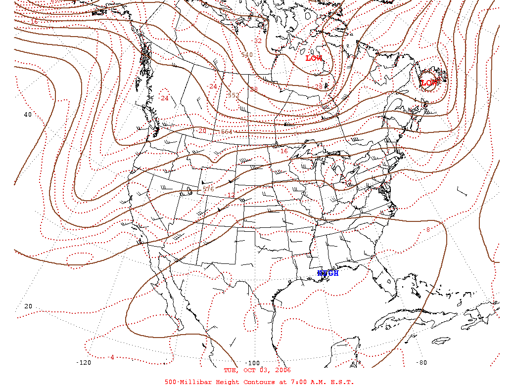
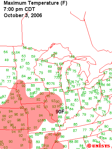
The heat reached its peak on October 3 as the ridge spread
into the central Midwest (Figure 6).
Daily high temperature
records and some monthly high temperature records were set in Iowa,
Missouri, and Illinois as highs pushed well into the 90s, 15°F to 25°F
above normal (Figure
7). The unseasonably warm weather
continued into October 4 for southern portions of the region, but a
cold front sweeping through the region ended the warm spell by late on
October 4.
Early October Record High Temperatures
| OCTOBER 1 | |||
| Location | Record | Old Record/Year | |
| Kansas City, MO | 94°F | 92°F/2002 | |
| Moline, IL | 89°F | 89°F/1897 | |
| Mankato, MN | 88°F | 88°F/1963 | |
| OCTOBER 2 |
|||
| Location | Record | Old Record/Year | |
| Kansas City, MO | 95°F | 94°F/1963 | |
| Columbia, MO | 94°F | 93°F/1897 | |
| Burlington, IA | 93°F | 93°F/1953 | |
| |||
| Location | Record | Old Record/Year | |
| Kansas City, MO | 95°F | 93°F/1954 | Third consecutive day with record high Ties October record for consecutive days 90°F or higher |
| St. Joseph, MO | 94°F | 91°F/1961 | |
| St. Louis, MO | 94°F | 92°F/1954 | |
| Columbia, MO | 94°F | 94°F/1897 | |
| Joplin, MO | 92°F | 90°F/2005 | |
| Springfield, MO | 91°F | 91°F/1969 | |
| Burlington, IA | 95°F | 92°F/1997 | Ties record high for month of October |
| Iowa City, IA | 94°F | 92°F/1997 | |
| Ottumwa, IA | 92°F | 91°F/1997 | |
| Moline, IL | 95°F | 93°F/1997 | New record for month of October |
| Jacksonville, IL | 95°F | 92°F/1997 | |
| Galesburg, IL | 94°F | 91°F/1997 | New record for month of October |
| Peoria, IL | 93°F | 92°F/1922 | New record for month of October |
| Springfield, IL | 93°F | 93°F/1954 | Ties record for month of October |
| Quincy, IL | 93°F | 93°F/1922 | |
Heavy Rain Causes Problems,
Misses Drought Areas
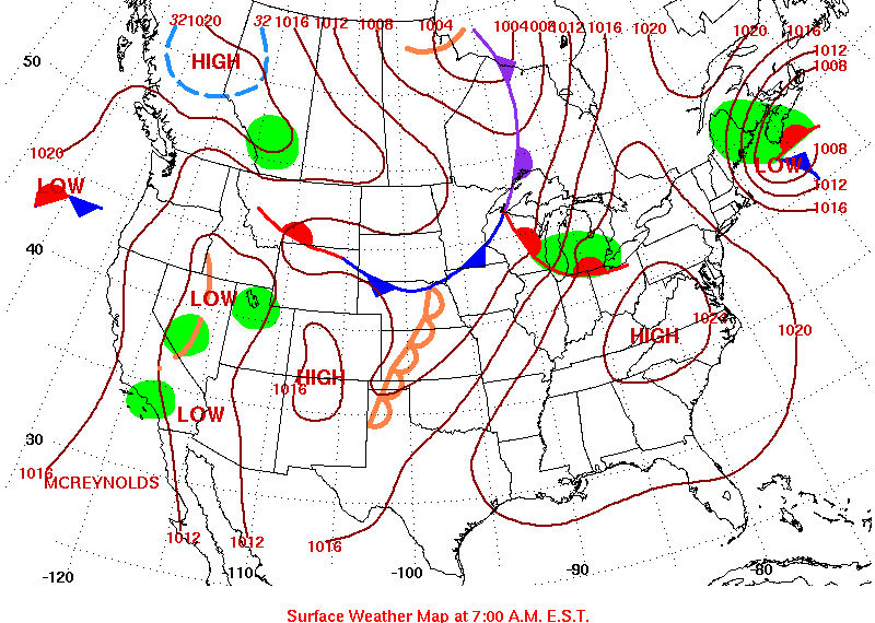
A frontal system stalled out over the Midwest, the dividing line between the unseasonably warm air south and cool air to the north, was the focus of thunderstorm development during the forst few days of the period (Figure 8). Unfortunately, most of the rain occurred outside the areas suffering from Severe to Extreme drought in Minnesota and Missouri (Figure 9). The southern portion of the drought area in Minnesota received from 0.50 to 0.75 inches of rain from the storms, but the more substantial precipitation fell further to the southeast in Wisconsin, Michigan, northeastern Illinois, and northern Indiana.
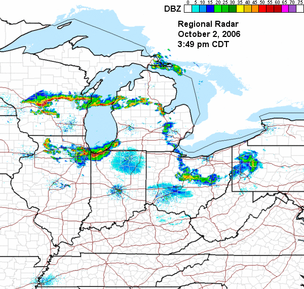
Several lines and clusters of severe thunderstorms struck
Wisconsin, Illinois, Michigan, and Indiana on October 2, with numerous
large hail and wind damage reports
especially in Wisconsin and northeastern Illinois. By mid
afternoon on October 2 a line of storms extended across central
Wisconsin, across Lake Michigan, into lower Michigan, and then angled
southeast into Ohio (Figure 10).
A second smaller but potent line of storms was moving
through northeastern Illinois into northwestern Indiana.
In
Wisconsin and Michigan, a number of locations set new daily rainfall
records, and street flooding was reported in some communities. Winds
gusted to 70 mph and hail was reported as large as one inch.
One
man was struck and killed by lightning in Trempealeau
County, WI in the early afternoon and another man nearby was
injured. Lightning striking a high school in Will
County, IL injured a student leaning against a doorway.
In La
Porte County, IN
a person was injured by lightning with the late afternoon storms.
Southeastern Wisconsin, northeastern Illinois, and northwestern Indiana
took another hit later in the evening. Severe storms
developed on
the tail end ofthe line that had been in central Wisconsin earlier in
the afternoon. This cluster of storms moved south into the
Chicago metropolitan area about 9:00 p.m. CDT and wreaked havoc
throughout the area (Figure 11).
The storms dumped as much as 4 inches of rain, flooding streets and
underpasses. Many buildings on the campus of Northwestern University in
Evanston were flooded and without power. High winds downed trees,
damaged buildings, and knocked out power. Commonwealth Edison
estimated that at the peak 320,000 customers were without power late on
October 2, and less than half of those were had power restored by the
next morning.
More Severe Storms
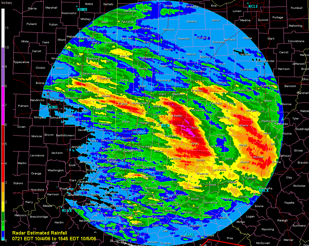
The frontal system reteated north into southern Wisconsin and Michigan on Ocotber 3 in response to another low pressure system approaching from the Central Plains. Thunderstorms broke out along and north of the boundary during the afternoon and continued overnight into the early hours of October 4, affecting Minnesota, northern Iowa, Wisconsin, and Michigan. A confirmed tornado near Cadillac, MI (Wexford County) caused damage to a house. There were a number of reports of hail 2.50 inches to 2.75 inches in diameter in Minnesota and Wisconsin. Thunderstorm winds toppled numerous trees and powerlines. Widespread wind damage occurred in northern Mason County, MI. The National Weather Service confirmed that thousands of tree were blown down or uprooted in the area. Several large groves of trees in areas the size of a football field were completely blown down. The damage was caused by thunderstorm straight-line winds from microbursts. No injuries were reported. More information on this event, including photos and radar, can be found at the NWS Grand Rapids web site
Storms continued to
develop ahead ofthe front on October 4 as it moved through Indiana and
Ohio. The were fewer storm
reports
than the previous two days, with most of the reports resulting from
damage to trees and power lines from high winds. Golf ball size hail
(1.75 inches) fell near the campus of The Ohio State University during
the evening hours, and hail was reported to be covering the ground in
parts of Columbus. Ross
County, OH was under a state of emergency after an estimated
3 to 5 inches of rain fell during the early morning hours of October 5 (Figure 12),
and the county used hovercraft to rescue people from their homes.