March 8-14, 2006
Midwest Weekly Highlights - March 8-14, 2006
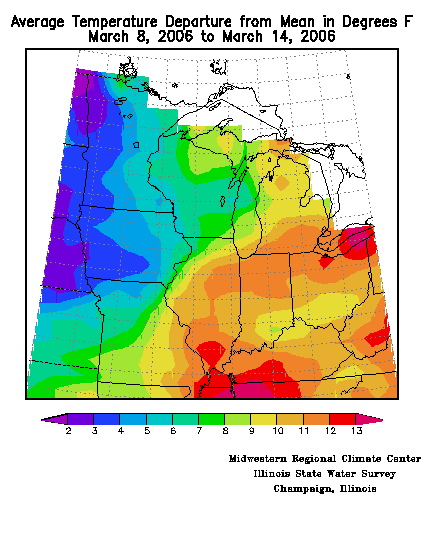
The second week of March was one of the most tumultuous weeks in recent memory. Headlines this week consist of deadly tornadoes, excessive rainfall/snowfall, and above average temperatures. The average daily temperature departures across the Midwest indicate that much of the region was above average for this time of year, with a gradient from southeast to northwest (Figure 1). Average daily mean temperatures for the second week of March ranged from 11-13°F above normal across Kentucky, Indiana, Illinois, and Ohio, to 6-8°F above normal across Missouri, Wisconsin, and Michigan. The coolest part of the Midwest this week was across Minnesota and Iowa, synonymous with deep snow cover. Despite this, temperatures were still warmer than normal, generally 2 to 4°F above normal. The warmer than average temperatures also resulted in a few new record high temperatures this week, including Paducah, KY, on the 12th with a temperature of 79°F (was 78°F in 1990), and Kansas City, MO, on the 8th with a temperature of 79°F (was 78°F in 1974).
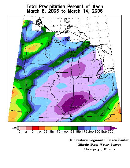
Precipitation for the
week was exceptional and frequent, with many locations receiving above
normal amounts of precipitation. This week, Wisconsin, Minnesota,
Iowa, and the Upper Peninsula
of Michigan
experienced precipitation
surpluses ranging from 150 to 300% above normal, while much of Ohio,
Indiana, Missouri, Illinois, and lower Michigan saw between 300
and 700% of the normal
precipitation (Figure
2). Despite the welcome precipitation across
portions of the
Midwest
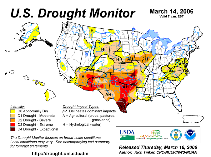
this week, long-term drought still exists, although it was scaled back slightly in Missouri, Illinois, and Indiana (Figure 3).
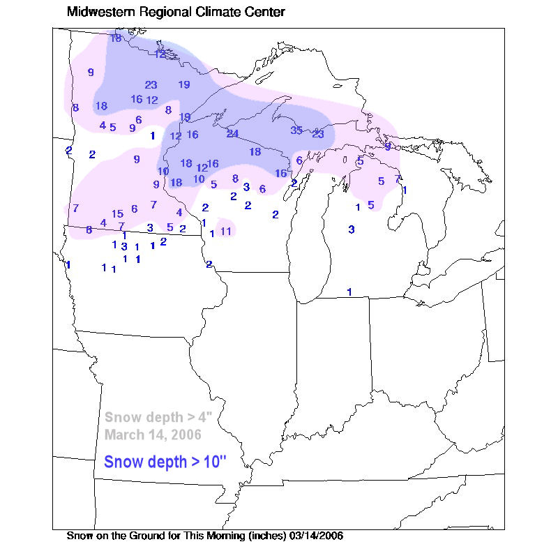
Snow was abundant this week, with many Minnesota, Wisconsin,
and Michigan residents finding themselves digging out after several
events tracked across this region of the Midwest. The snow cover
map from March 14 illustrates how expansive and deep the snow
depth remains across the northern tier states (Figure 4).
Winter Hangs On in the Northwoods
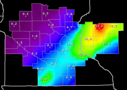
Old-man winter gripped the northern Midwest this past week, giving residents white-out conditions amidst heavy snow and high winds. Multiple opportunities for snow existed this week, with a culmination of a massive snowstorm on March 12-13. On the 8th, a two areas of low pressure scooted northeast along a stationary boundary, which aided to produce some minor accumulations of snow across central and northern Minnesota (Figure 5). On the 11th, an area of low pressure moving out of Nebraska and into southern Minnesota brought a swath of snow to the north side of the track, depositing a quick 2-5 inches of snow (Figure 6). Finally, on the 12-13th, an intense are of low pressure (Figure 7) moved northeast along a strong temperature gradient (from northwest to southeast), and this produced blinding snows and windy conditions across southeastern Minnesota and much of central and northern Wisconsin. The National Weather Service Office in Chanhassen, MN (just west of Minneapolis), produced a neat figure detailing how significant the snows were across this region (Figure 8).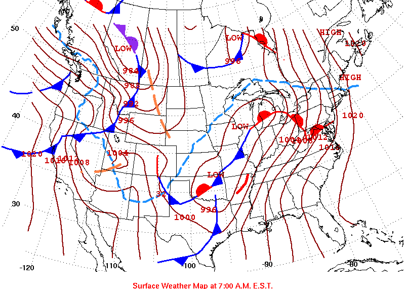
Severe Weather Strikes Early
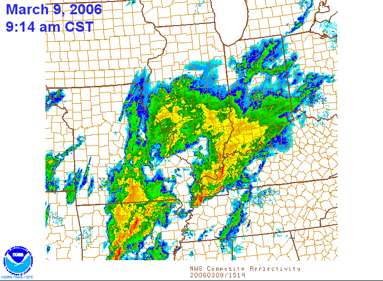
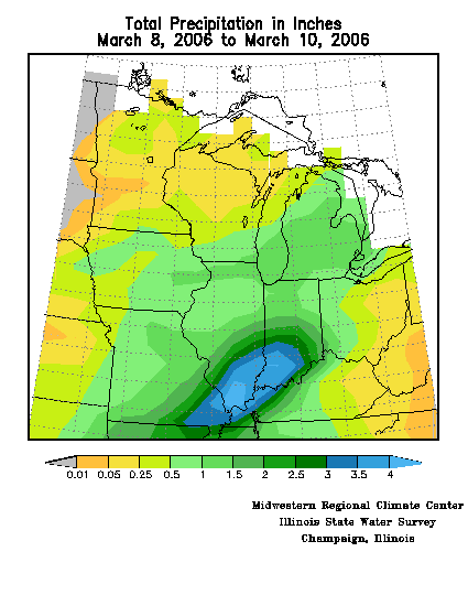
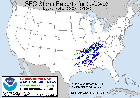
On March 9-10, several systems ejected out of the longwave trough that enveloped the western U.S.(Figure 9), leading to a series of thunderstorm complexes which brought numerous rounds of severe weather, heavy rain, and warm temperatures. Heavy rain and embedded thunderstorms occurred in Missouri, Illinois, Indiana, and Kentucky on the 9th, bringing flooding to some parts of the Midwest (Figure 10). In Greenfield, IN, Water Department officials reported 1.63 inches of rain from 8am on the 9th to 8am on the 10th. In Sumner, IL, flash floods shut down streets and consumed a ball park. In Cape Girardeau, MO, several streets were reported to be closed due to floodwaters, and a handful of hydroplaning accidents were also reported. No one was seriously injured. Rainfall totals across this portion of the Midwest generally ranged from 1-3 inches, with locally higher amounts (Figure 11).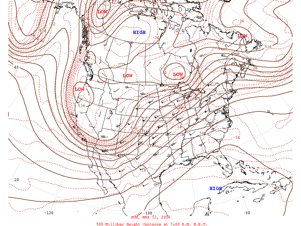
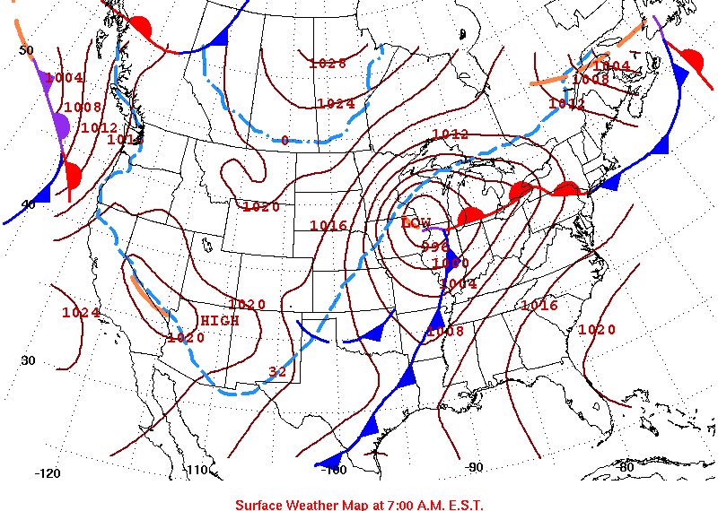
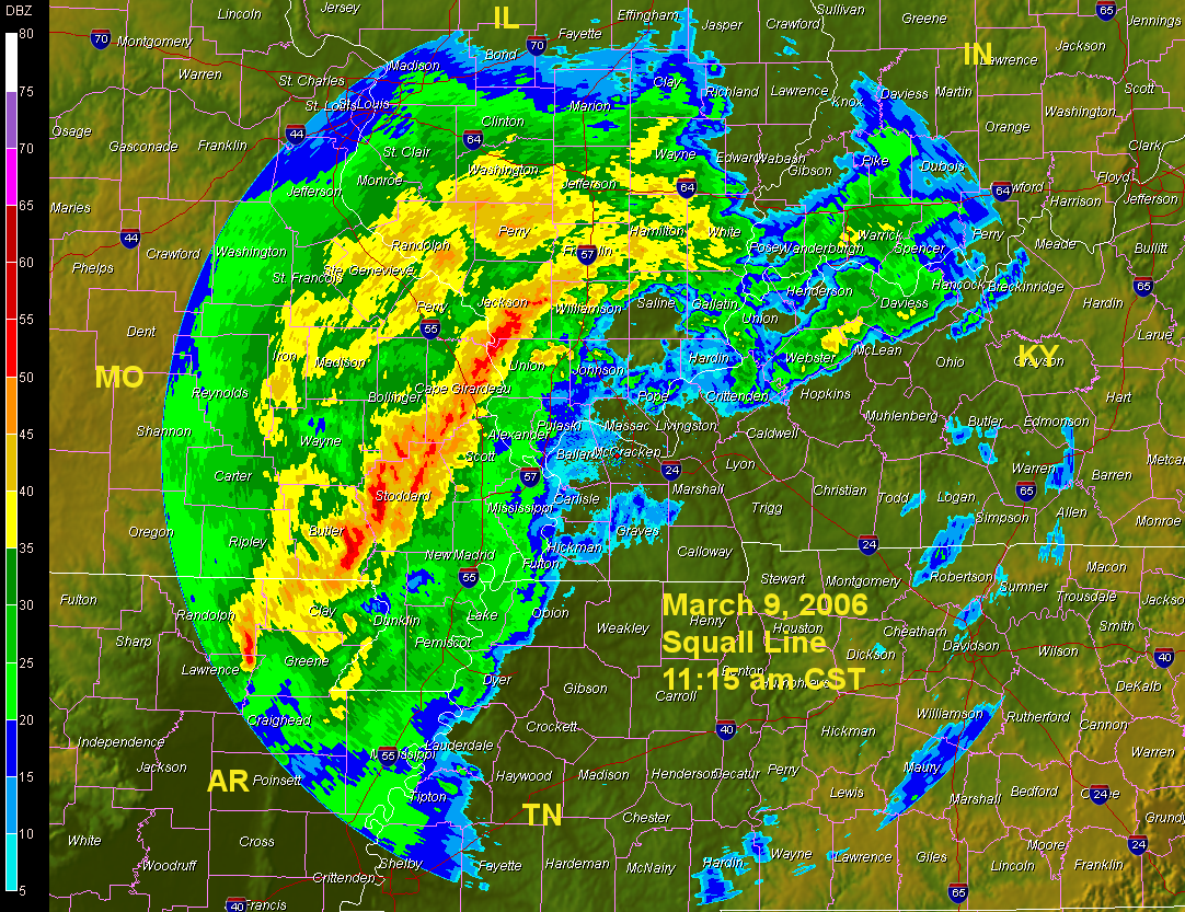
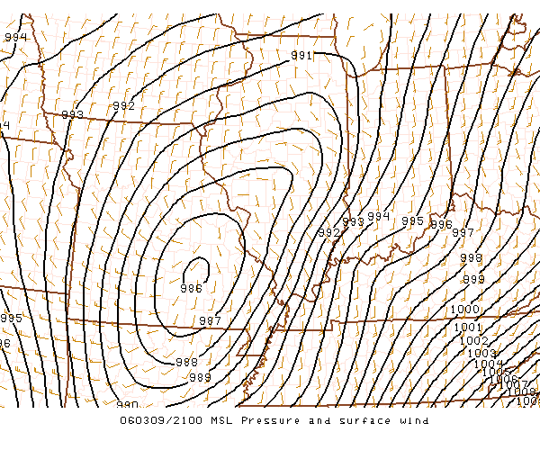
Strong thunderstorms that produced the heavy, flooding rains, also produced quite a bit of damage in Missouri, Illinois, Indiana, and Kentucky, as the region was hit by two rounds of severe weather on the 9th. A squall line (Figure 12) raced eastward on the 9th, producing over 300 reports of damage (Figure 13), and this was followed by additional thunderstorms near the center of an intense 986 millibar low pressure system (29.18 inHg) (Figure 14). Late in the evening, after passage of the first line of strong thunderstorms, and just after the passage of the surface low and attendant thunderstorms, strong gusty winds caused a myriad of problems for residents in Illinois, Indiana, and Kentucky. The gusty winds were caused by an isallobaric rise/fall pressure couplet that co-existed with the last round of thunderstorm activity (Figure 15). This couplet produced winds from 40 to 60 m.p.h, which helped to uproot trees and knock down power poles, aided by the exceptionally wet soils. In Indianapolis, the 60+ m.p.h. winds snapped trees, blew debris into roadways, and accounted for 2,500 customers to be in the dark without electrical power. The National Weather Service Office in Louisville, KY, has put together the following web site, which includes pictures of the devastation caused by the severe weather (http://www.crh.noaa.gov/lmk/?n=9mar06).
Tornadoes Ravage the Midwest
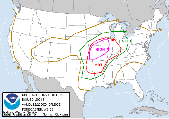
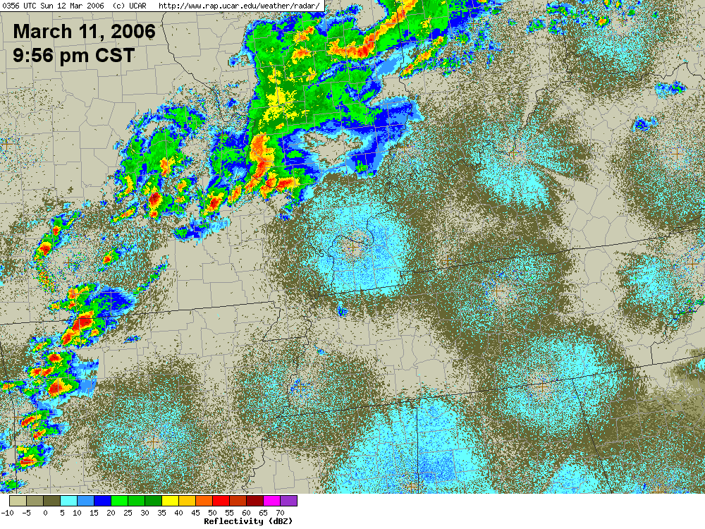
A second, even more impressive and devastating severe weather outbreak occurred on March 11-13, ahead of an area of low pressure moving out of the plains, warranting the issuance of a "High Risk" by the Storm Prediction Center (Figure 16). On Saturday night, March 11, thunderstorms erupted across eastern Missouri and southern Illinois (Figure 17). These storms quickly became severe, and a tornado struck Perry County, MO, causing over a dozen injuries and two fatalities. The tornado was rated as F3 (max winds 170 mph). Of those injured, four persons were picked up by tornadic winds and were tossed 100 yards, while being struck by debris. In the same event near St. Mary, MO, two persons were killed when they tried to escape from their mobile home park after seeing the storm developing on radar on their computer. As they were trying to get out of the way of the tornado in their car, the tornado picked up the car and slammed it into a roadside propane tank, killing both just 50 yards from their home. The same tornado split a brick ranch in half, tossed mobile homes, caved in garages, and shredded trees. Another tornado struck the popular tourist town of Branson, MO, ripping the roof off of a McDonald's restaurant, and pelting the town with softball sized hail, which damaged homes and downed power lines.
As the night progressed, the thunderstorms organized into a line, causing widespread wind damage in Massac County, IL. Here, survey results from the National Weather Service Office in Paducah, KY indicate that peak winds were 75-80 mph, causing extensive damage to trees and a few grain bins along a 14 mile path. Fortunately, there were no injuries or fatalities with this line of thunderstorms. The same line of storms raced through Randolph County MO, causing tremendous destruction to homes, businesses, and tossing cars several hundred yards from their initial positions. One person was injured when flying glass abruptly struck him in the face near the town of Bremen, IL. Unfortunately, the severe thunderstorms also brought flash flooding, especially to southern Illinois and Indiana. In Mount Vernon, IL, a a couple had to be rescued from their car after it was swept off a road just east of town, into a field of high water. In Centralia, IL, the rainfall totals from the 8th through the 12th of March exceeded 5 inches.
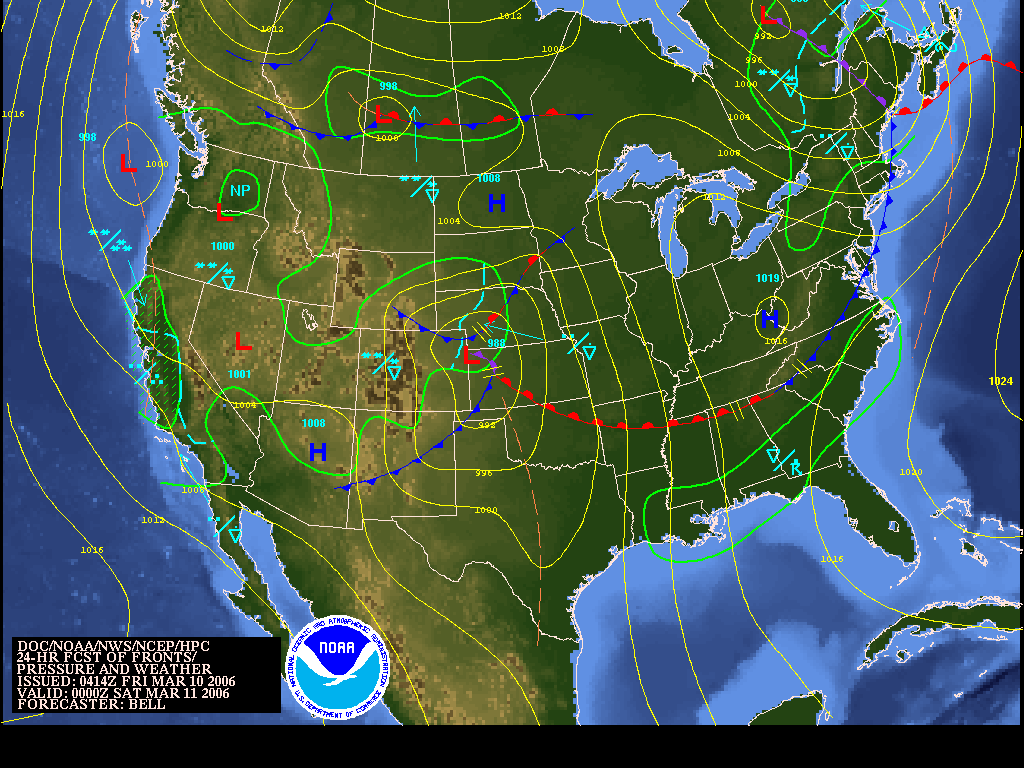
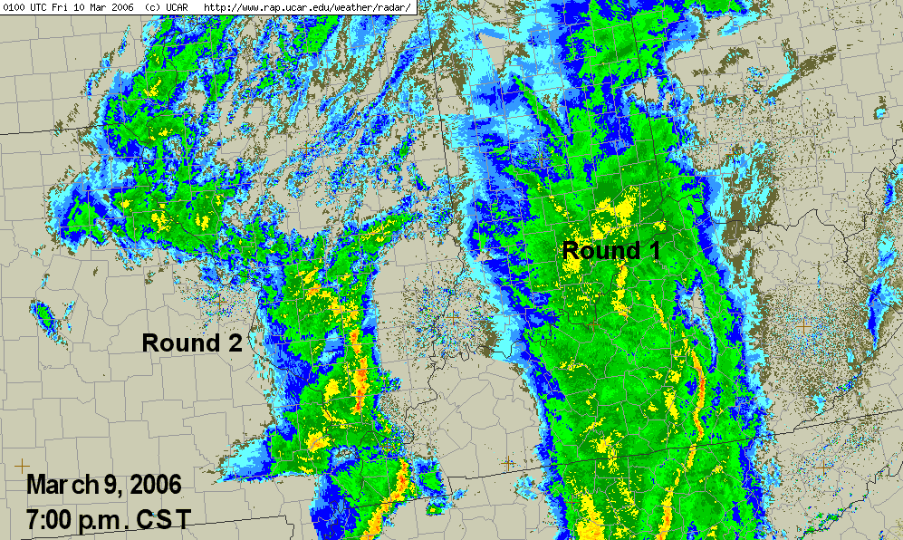
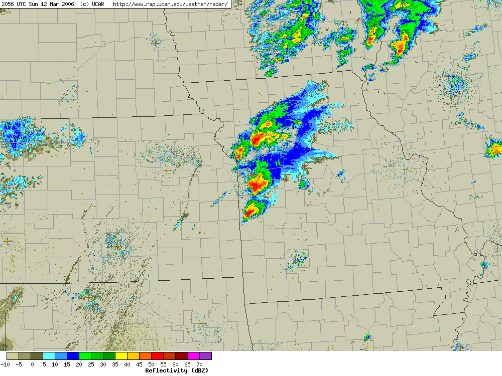
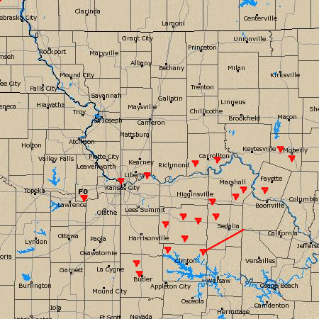
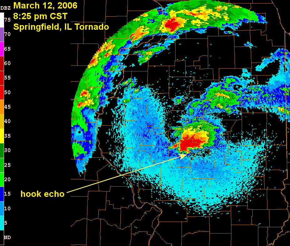
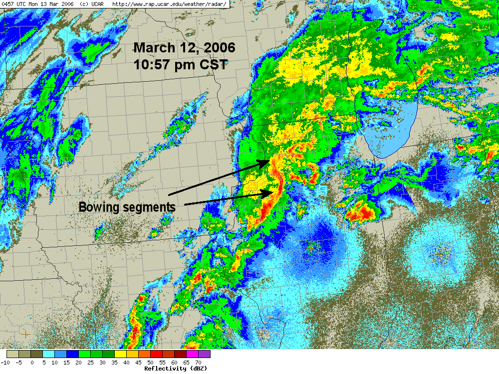
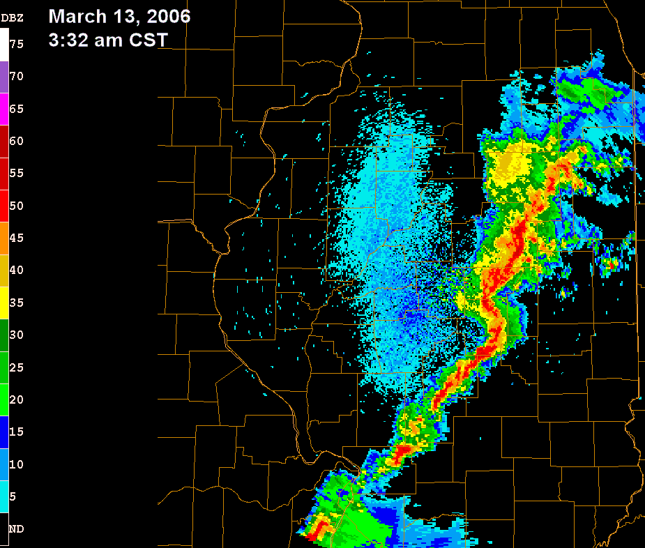
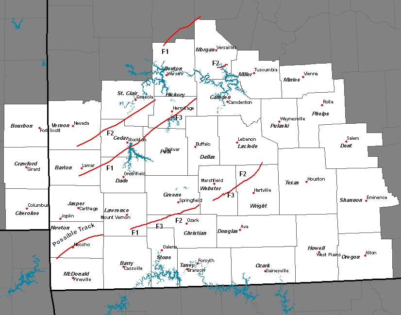
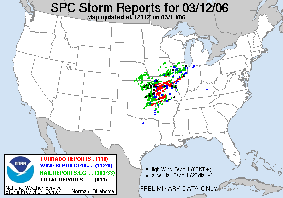
The biggest event of the week, by far, occurred on Sunday, March 12. A warm front, draped across Missouri and Illinois was a focal point for severe thunderstorms, and a secondary area of favored storminess was along an eastward advancing cold front / dry line, moving into western Missouri late on the 12th. Thunderstorms initiated around 2:00 pm CST, and became supercellular as they raced across Missouri and into Illinois (Figure 18). Several of these storms produced tornadoes just south of the Kansas City, MO area (and their tornado tracks can be seen here, Figure 19, National Weather Service, Kansas City, MO). One supercell storm, isolated from all other storms, formed over extreme western Kansas, and moved across Missouri, Illinois, and northern Indiana before decaying in southern Michigan - some 10 hours after its initiation (Figure 20). This storm was responsible for numerous tornadoes, and significant damage, including striking the town of Springfield, IL, the capital of Illinois. Around 8:25pm, a large supercell thunderstorm, with attendant "hook echo" spawned an eventual F2 tornado on the south side of town (Figure 21), injuring 23 persons. The tornado, which at its peak intensity was about a half-mile wide, caused extensive destruction to homes, businesses, and schools, even including the Illinois Emergency Management Agency, which lost segments of its roof, despite being several blocks north of the twister. The main body of the supercell covered Logan County, IL, just northeast of Springfield, IL, were two homes were completely destroyed, and a 400-foot cell phone tower was toppled. As the storm moved northeast, it deposited a hailstone of 4.25" in Fisher, IL, just northwest of Champaign-Urbana. The storm finally fell apart in southern lower Michigan before the next line of storms, some with bowing segments, raced across Illinois and Indiana (Figure 22). These storms produced a peak wind gust of 107 mph at the Quad City Airport in Moline, IL, breaking the old record wind gust of 81 mph set on August 21, 1987. Meanwhile, ahead of the dryline and cold front in Missouri, additional discrete cells were developing, and these eventually coalesced into a squall line as it moved across the Midwest during the early morning hours on the 13th (Figure 23). Additional reports of wind damage and a few tornadoes also accompanied this line of storms. The Springfield, MO, National Weather Service Office put together a nice graphical summary of the tornadoes that tracked across their region (Figure 24).
Further north, across the Chicago metropolitan area, a microburst, producing winds in excess of 70 mph, was responsible for tearing off roofs of apartment buildings, and causing major damage to at least seven garages in a three-block area, in Bridgeview, IL. Additionally, heavy rain, dime-sized hail, and dangerous lightning pounded the southern suburbs, including Joliet, IL, where lightning was the cause of a house fire, and heavy rains flooded low-lying areas and streams. The heavy rains did not force the closure of any expressways in Chicago, IL, but numerous accidents, spin-outs, and reports of hydroplaning made local dispatchers work overtime.
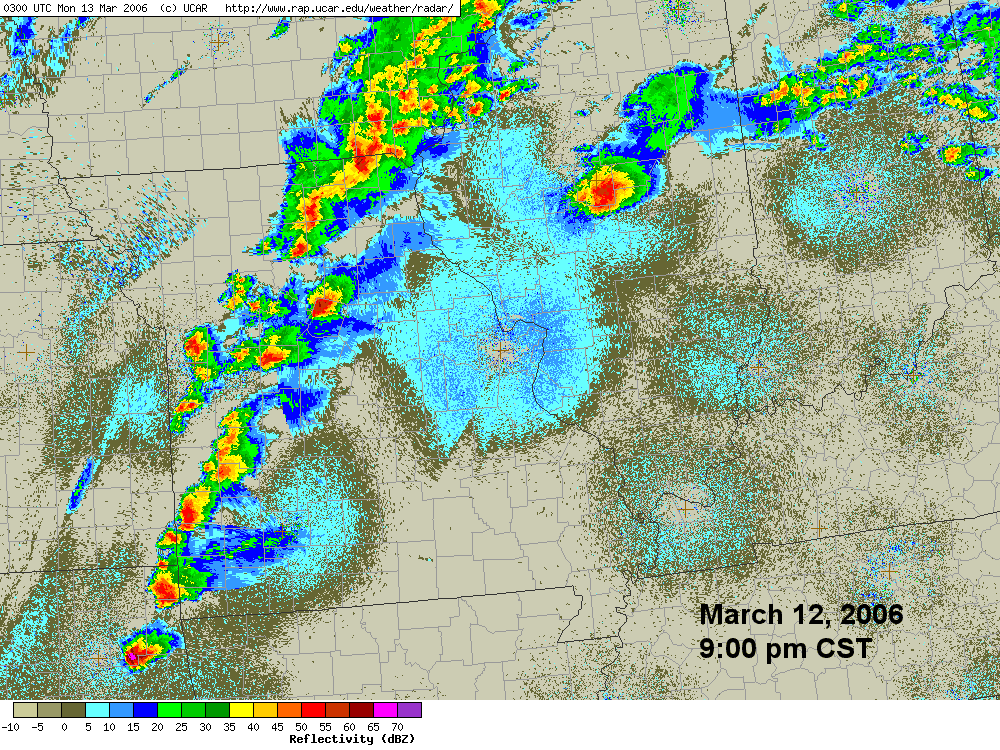
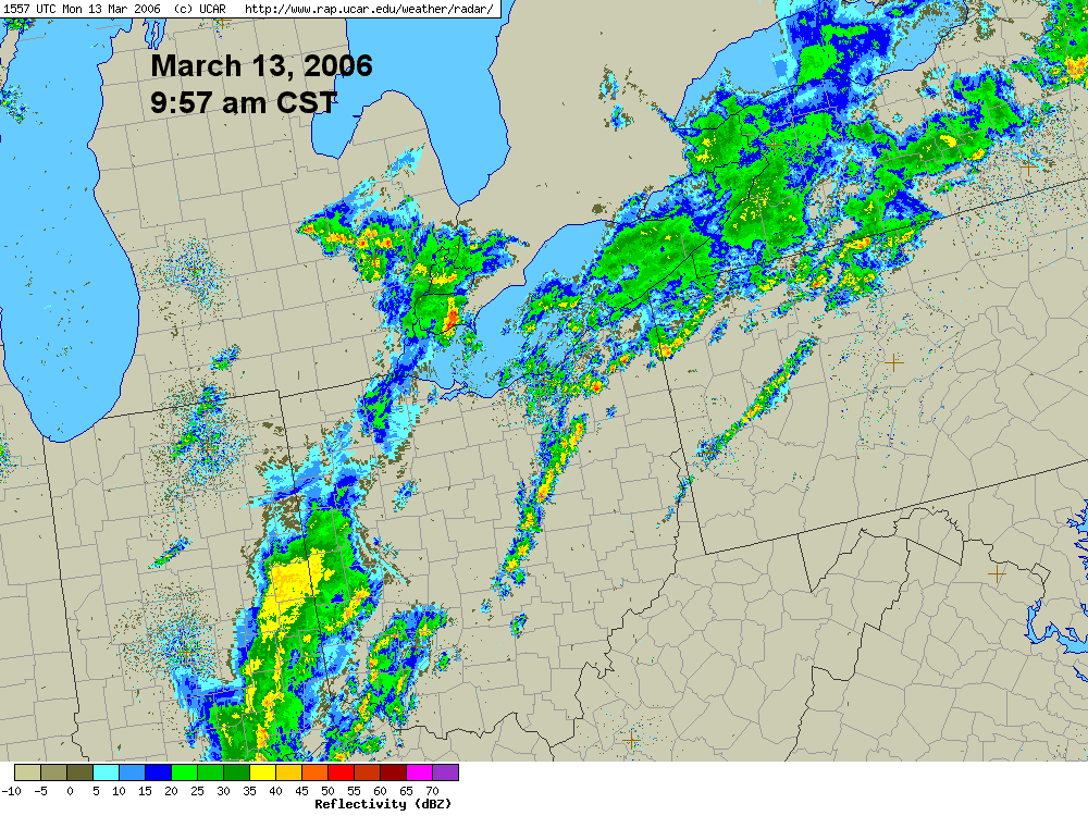
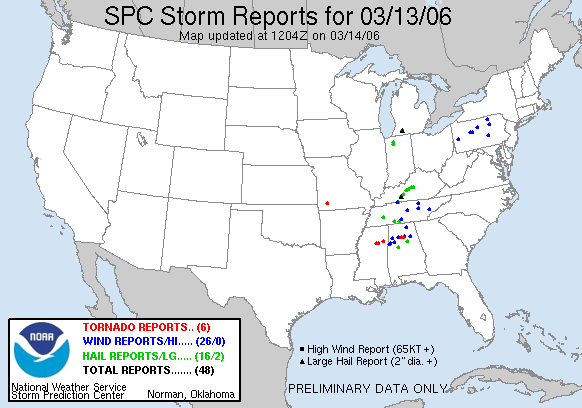
When all was said and done, this event produced in excess of 600 reports of severe weather, many of which occurred in Missouri, Iowa, and Illinois on March 12 (Figure 25). The following day, March 13, the squall line continued eastward through Indiana, Kentucky, Michigan, and Ohio (Figure 26), producing significantly less in the way of severe weather (Figure 27), and thereby minimizing impacts.
Several National Weather Service Offices have assembled web pages devoted to this event, and are provided here as an additional resource.