July 8-14, 2015
Midwest Weekly Highlights - July 8-14, 2015
Wet Weather Refuses to Leave
Yet another week of heavy rain led to above normal precipitation across most of the Midwest (Figure 1). Missouri, central Illinois, Indiana and western Kentucky were hit hard with 3-5 inches of precipitation for the period, with locally higher amounts in some spots (Figure 2). Drier conditions were seen throughout Iowa, western Minnesota and northern parts of Michigan and the U.P. These areas saw less than half the normal precipitation for the period with northern Lower Michigan and northwest Iowa seeing less than 10 percent of normal (Figure 3).
With meteorological summer (June-August) near the halfway point, Missouri, Illinois, Indiana and Ohio have dealt with one of the wettest summers on record so far. Over 10 inches of rain fell across a majority of these states, with more than 15 inches in some areas
(Figure 4). This led to departures from normal of more than 10 inches in parts of Missouri, central Illinois and northern Indiana (Figure 5), which is over twice the normal amount (Figure 6). Statewide precipitation in Illinois and Indiana already surpassed the normal amount for the summer period between June and August. Continued above normal precipitation could lead to state records for the summer season in both states. Illinois’ state record for June through August precipitation is 18.51 inches set in 1993, while Indiana’s statewide record is 20.31 inches set in 1958.
Cool Temperatures Stick Around
After a cool first week of July, below normal temperatures continued across most of the Midwest
(Figure 7). Areas north of the Ohio Valley through central Wisconsin were all below normal, with northern Indiana the coolest spot at 4-7°F below normal. Temperatures were closer to normal across northern Wisconsin, southern Minnesota and the U.P. of Michigan. Near normal temperatures were also common in southern parts of Missouri and northern Kentucky, with a few above normal temperatures along the southern border of Missouri and Kentucky. Northern Minnesota was also 2-4°F above normal.
Heavy Rainfall
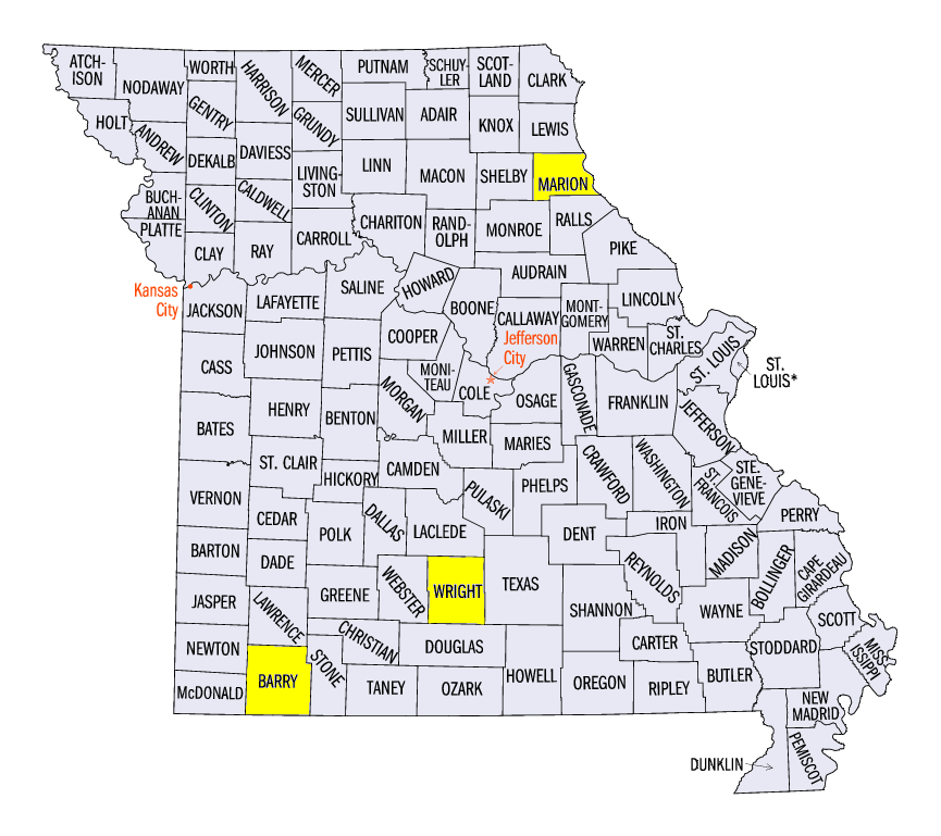
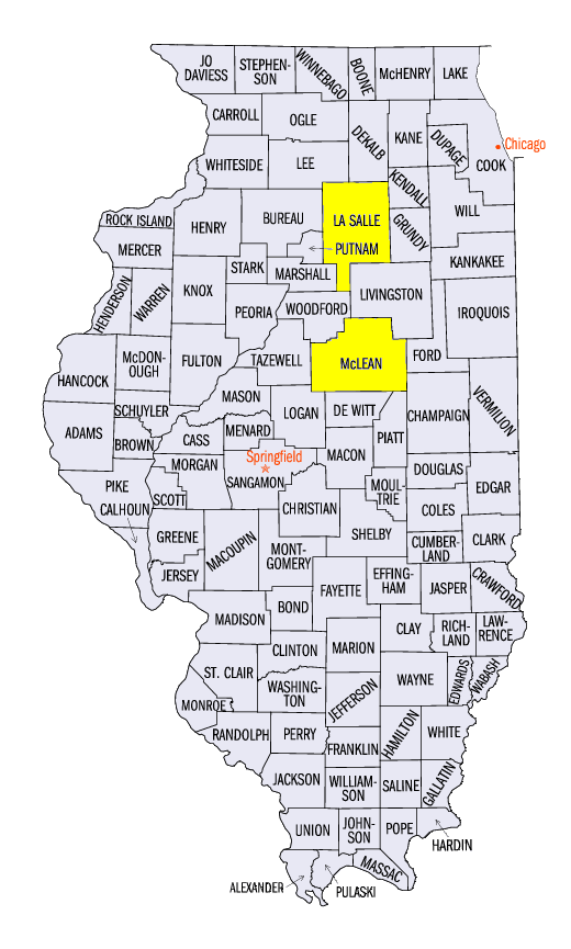
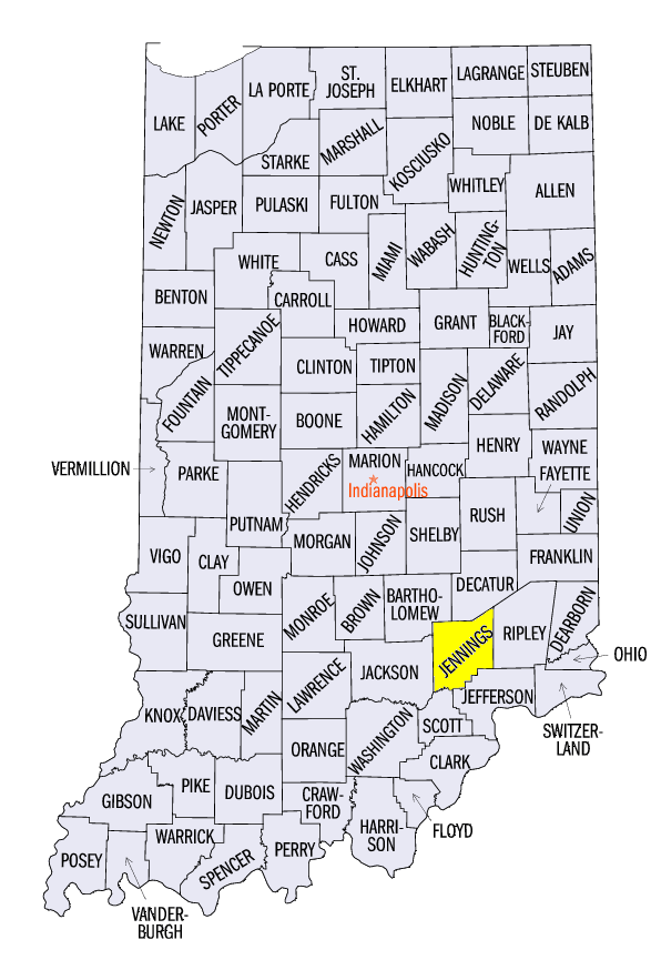
Excess rainfall continued across the Midwest which led to flash flooding in many cases. Many stations in Missouri, Illinois, Indiana and Kentucky had more than 3 inches of rain over a 24-hour period. On July 8, the Washburn station in Barry County, MO recorded 3.81 inches of precipitation, while a CoCoRaHS observer north of Seligman had 5.65 inches. In Wright County, MO, the Hartville station received 7.01 inches of rain over the three day period of July 8-10. Most of that precipitation fell in the 24 hour period prior to the morning of July 10, where 4.14 inches of precipitation was recorded. July 12 proved to be wet in Marion County, MO as 4.88 inches fell southwest of Taylor and 3.70 inches fell north of Palmyra. Spots in Illinois were just as wet, with the Bloomington/Normal airport receiving 4.42 inches on July 8, while many other spots in McLean County collected over 3 inches of rain through the morning of July 9. An incredible 5.05 inches was also recorded through the morning of July 14 northeast of North Vernon, IN in Jennings County, thanks in part to a long track wind storm that moved through the region.
Wind Storm Travels Over 800 Miles
An active week of severe weather was punctuated by a long track wind storm that traveled over 800 miles, in nearly 24 hours on July 12-13 (Figure 8). A very moist and unstable atmosphere caused storms to fire in west central Minnesota during the afternoon on July 12, dropping a few tornadoes. These discrete cells eventually congealed into a more linear shape as the storm began to move through central and eastern Minnesota during the evening and overnight hours. The storm lost some strength overnight as it passed through Wisconsin, but wind damage was still seen in western and southern parts of the state. By morning on July 13, the storm had begun to move into the Chicagoland area. Few wind damage reports were recorded as the storm moved through Illinois, but the northern edge of the system strengthened over Lake Michigan, causing wind damage along the eastern shores in Michigan. Aided by heating in the mid to late morning hours, the storm gained strength as it passed through Indiana. Indianapolis was hit particularly hard as thousands were left without power. The storm maintained its strength as it approached the Ohio River in the early afternoon. As the storm passed through Cincinnati, Major League Baseball decided to change the rules to the Home Run Derby skills competition for later that evening because of the threat of continued rain. Wind damage continued along the storm's leading edge into eastern Kentucky during the afternoon. The storm finally lost steam over central Virginia and North Carolina in the evening hours.
More Severe Weather
While this wind storm caused a lot of attention, more severe weather affected the region during the period
(Figure 9). Strong thunderstorms moved through southwest Missouri and east-central Kentucky on July 9, causing trees to fall across roads. More thunderstorms fired across eastern Kentucky on July 10, causing more wind damage and three brief EF-0 tornadoes. Strong thunderstorms fired behind the long track wind storm on July 13, causing more wind damage in Wisconsin. A few supercells in far eastern Iowa and northern Illinois dropped large hail with a 3.75 inch stone recorded in La Salle County, IL and a 4.25 inch softball size hailstone in Clinton County, IA. Storms across extreme northern Missouri also caused widespread wind damage during the evening hours. These storms moved into southwestern Illinois overnight before dissipating. Another line of severe thunderstorms formed across Ohio in the early afternoon on July 14, leading to wind damage and hail across the state. The storm moved into eastern Kentucky later in the afternoon and continued to cause wind damage.
Flood Waters Holding Serve
With continued rain over flooded rivers, flood stages held steady over the period. Major flooding continued to occur along the Illinois River from Havana through Hardin. Moderate flooding also held steady along the river from Peoria through Henry. Minor flooding remained along the Wabash River as well, with many smaller rivers in Indiana also above flood stage. The Mississippi River also dealt with minor and moderate flooding from Quincy, IL through Louisiana.
-BJP-