June 15-21, 2015
Midwest Weekly Highlights - June 15-21, 2015
Rain Continues to Fall
Wet weather continued for most of the Midwest this week as a moist airmass lingered over the region. Heavy rain pummeled Missouri, Illinois, Indiana and Ohio with 3-6 inches of precipitation this week, including some locally higher amounts
(Figure 1). In most cases, this was 2-4 inches more than normal (Figure 2). The wettest areas in eastern Missouri, southern Illinois and southwestern Indiana saw more than 5 times the normal amount of precipitation for the week
(Figure 3). Lesser precipitation fell across the upper portions of the region, but most areas were slightly above normal.
Near Normal Temperatures Prevail
Temperatures were largely near normal this week across the region, with only Kentucky, Minnesota and the U.P. of Michigan experiencing temperatures more than 5 degrees from normal (Figure 4). Kentucky was 4-6°F above normal for the week, while the northern half of the Ohio River Valley dealt with temperatures only slightly above normal. Far northern Minnesota and the U.P. of Michigan saw temperatures 4-7°F below normal while Wisconsin, Iowa and northern Illinois were only a degree or two below normal.
Flooding Continues
Another week of heavy rain led to more flooding across the Mississippi and Missouri River Valleys as the wet month of June continues for Missouri, Illinois and northern Indiana (Figure 5). River gauges across Illinois, Missouri, Indiana and Ohio rose throughout the week. Flash flooding was a big concern in Chicago on June 15th, where roads were closed throughout the metro area, including I-290, a main artery to the downtown area. The Chicago Blackhawks were forced to wait to celebrate their National Hockey League championship victory that night as the championship trophy, the Stanley Cup, was delayed from arriving due to flooding.
With heavy rain occurring on multiple days in southern Illinois and Missouri, many river gauges went into moderate and major flood stage. A particularly strong storm near Springfield, MO caused the James River to rise from 5 feet to 22.1 feet in less than 24 hours (Figure 6). The unofficial record at that gauge was 22.0 feet. Many gauges along the Illinois River were at moderate and major flood stage this week, with many of these sites nearing their crest at this writing. Flood warnings and advisories are in effect along most of the Mississippi River from Quincy, MO through Baton Rouge, LA. Flooding along the Wabash River also continues south of Lafayette, IN. Unfortunately, another week of moderate to heavy rain looks possible across the central portions of the Midwest to end the month
(Figure 7), adding more upstream water to these flooded rivers. Stay up to date on flood stages and warnings from the National Weather Service's River Forecast Centers.
Severe Weather Continues
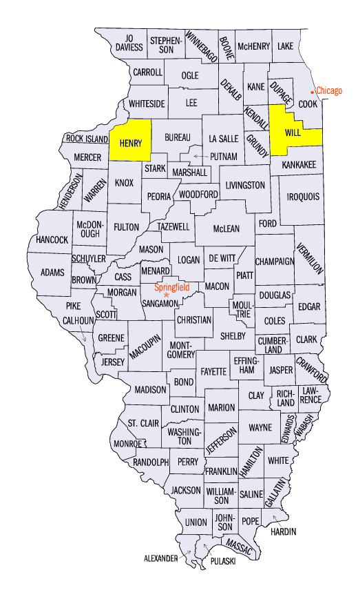
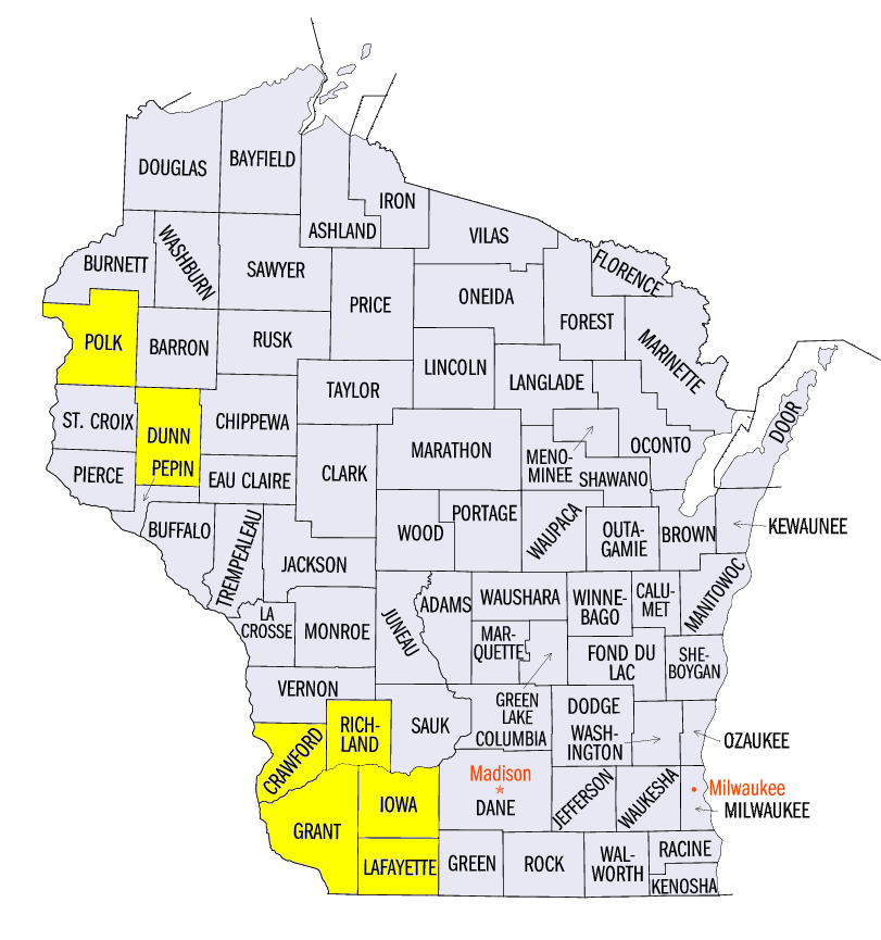
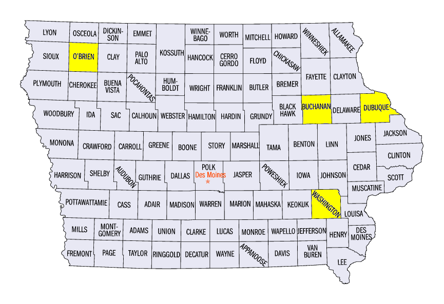
Strong thunderstorms were common this week across the central and southern parts of the region (Figure 8) as multiple systems and the remnants of Tropical Storm Bill created a conducive environment for severe weather. While flooding was the main concern in the Chicagoland area on June 15th, an EF-1 tornado moved through the Will County, IL area, southwest of the city. Only a few reports of wind and hail were seen on June 16th, but brief tornadoes were sighted in Polk and Dunn Counties, WI on June 17th. Strong winds caused damage throughout Indiana, Kentucky and Ohio on June 18th. On June 19th, tornadoes spawned in far southern Illinois as the remnants of Tropical Storm Bill moved through the area. A derecho tracked through far eastern Iowa into central Illinois and Indiana on June 20th, causing wind gusts up to 70 mph. Before the derecho formed, two EF-1 tornadoes formed in Henry County, IL and Washington County, IA.
Strong storms formed in the Dakotas on the night of June 21st, bringing wind damage to northwest Iowa and southwest Minnesota as another derecho formed overnight. A peak wind gust of 95 mph was observed in O’Brien County, IA as an airport hangar was destroyed. This derecho continued into the morning of June 22nd, bringing wind damage to central and eastern Iowa and southwestern Wisconsin. A wind gust of 94 mph was observed in Buchanan County, IA with a 72 mph wind gust at the Dubuque Regional Airport in Dubuque County, IA. Trees and power lines were toppled and grain bins were smashed in like soda cans as the storm moved into Grant, Crawford, Richland, Iowa and Lafayette counties in Wisconsin. Roofs flew off of homes while entire fields of corn were flattened. As the storm reached south-central Wisconsin and north-central Illinois, it lost most of its intensity and quickly weakened.
Tropical Storm Bill Moves Through Midwest
Tropical Storm Bill formed in the Gulf of Mexico over the three day period of June 14-16th before making landfall on June 16th near Houston, TX and tracking across the eastern half of the United States (Figure 9). The storm was very lackadaisical in its movement after making landfall, spending a few days in eastern Texas and Oklahoma and causing flooding in those areas. Bill then slowly turned to the northeast on June 18-19th, tracking through southern Missouri as a cold front helped steer Bill across the southern Midwest. Heavy rain fell throughout Missouri and southern Illinois on June 19th and spawned severe weather and tornadoes in southern Illinois. Aided by the steering cold front’s winds, Bill exited the Midwest on June 20th and tormented the Mid-Atlantic with heavy rain and severe storms.
-BJP-