April 8-14, 2015
Midwest Weekly Highlights - April 8-14, 2015
Wet Week
After a dry winter, many parts of the Upper Midwest had good week of rain, leading to above normal precipitation
(Figure 1). Multiple rounds of storms rolled through as a system developed on April 8-9. Most of southern Wisconsin and west-central Michigan received more than 2 inches of precipitation over the week, with isolated areas seeing over 3 inches (Figure 2). The Ohio Valley continued to see above normal precipitation this week, which brought back flood warnings in Kentucky, Indiana and Illinois. Snow was also seen this week, with the heaviest snowfall in north-central Wisconsin and the U.P. of Michigan (Figure 3). Totals of 6-8 inches were common in these areas. A few inches of snow also fell in northern Minnesota. Surprisingly, western Iowa also saw up to an inch of snow from the storm system on April 9.
Warmth Remains
After above normal temperatures returned to the Midwest last week, the entire region remained above normal for this week (Figure 4). Most of the Ohio Valley and Missouri saw temperatures 8-12°F above normal for the week. Northern Minnesota also felt the heat with temperatures 6-10°F above normal. The relative cool spot was through Iowa and central Wisconsin where temperatures were only 2-5°F above normal. High temperatures averaged in the 70s in the southern half of the region, while the coolest places around the Great Lakes averaged highs in the upper 40s to 50s (Figure 5). After a mainly below normal winter and March (Figure 6), the first half of April has been above normal for almost the entire region
(Figure 7).
Flooding Returns to Ohio Valley
While river stages are not as high as they were in March in the Ohio Valley, they have been near flood levels for quite a while. This April has already moved into the top 5 wettest Aprils on record in Louisville, Lexington and Frankfort, Kentucky. Many rivers along the Ohio River have moved above flood stage once again. Flooding threats are only minor for most of these rivers at this point, according to the Ohio River Forecast Center (Figure 8). However, more heavy rain could create major flooding concerns.
Drought Holding Status Quo
While the Ohio Valley continues to see excess rain, Minnesota and Wisconsin continue to deal with moderate drought conditions according to the latest drought monitor (Figure 9). Some relief came this week to Wisconsin as heavy rainfall brought areas in southern Wisconsin back to near normal precipitation since January 1, 2015 (Figure 10). However, Minnesota and northern Wisconsin are still 1-3 inches below normal since January 1.
Severe Weather Outbreak April 8-9
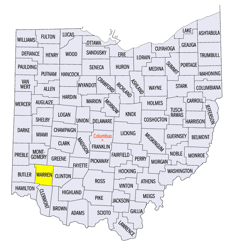
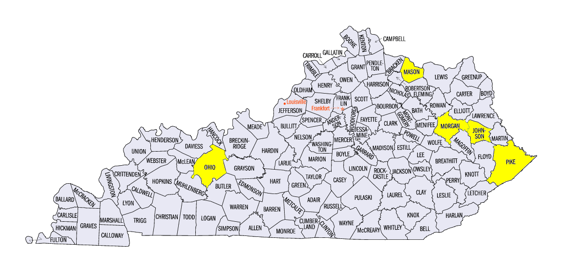
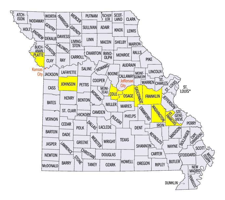
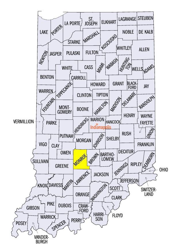
A major two-day severe weather outbreak rocked the Midwest on April 8-9 as a storm system developed over the region. Over 700 reports of hail, wind and tornadoes were made nationwide over the two day period, with many of them in the Midwest (Figure 11). On April 8, a well-defined bow echo moved from central Illinois through Ohio during the morning and early afternoon hours along a developing warm front. Pea-sized hail fell in Illinois before one inch hail was reported in Indiana and Kentucky. Damaging wind reports were seen throughout southern Ohio as the storm moved through. The highest reported wind speed reported in the region for April 8 was in Warren County, OH at 73 mph. More storms fired closer to the developing low pressure system in Missouri during the morning hours, bringing some hail reports. However, the largest hail in the region was seen in the afternoon hours. The largest hailstone found was four inches in diameter near Sullivan, MO. Two inch diameter hail was recorded in all the yellow shaded counties in Kentucky and Missouri and Indiana at some point during the afternoon.
The storm system continued to develop into April 9, where at least one storm report was recorded in each state in the nine state region. The storm fully matured around midday April 9, with a well-defined outflow boundary along the storms’ cold front from central Iowa through Oklahoma and northeast Texas. The northwest quadrant of the storm was cold enough to drop snow across northwest Iowa while bringing up to 8 inches of snow to the U.P. of Michigan. Along and east of the cold front, the environment was ripe for strong thunderstorms. Hail reports were common throughout Illinois, southeast Iowa, southern Wisconsin and northeast Missouri. Wind reports were seen throughout southern Indiana, central Kentucky and southern Ohio. The highest wind gust reported at Waukegan Harbor in Lake County, IL was 91 mph. EF-0 and EF-1 tornadoes were also reported north of the Quad Cities, near Evansville, IN, near Springfield and Peoria, IL, near Cape Girardeau, MO and just west of St. Louis, MO. The main story of the afternoon, however, was the EF-4 tornado that ripped through northern Illinois.
Franklin Grove to Fairdale, IL Tornado on April 9
Seven tornadoes moved through north-central Illinois on April 9. The largest of these tornadoes was rated an EF-4 and went along a 30-mile path from Franklin Grove, IL to Fairdale, IL, which is about 20-25 miles south-southeast of Rockford, IL. This tornado was the first EF-4 tornado to hit Illinois since November 17, 2013. The tornado started in the vicinity of Franklin Grove, IL near Interstate 88 at 6:39pm CDT. The tornado was rated EF-0 and EF-1 until after it passed the Kyte River just west of Flagg Center, IL. EF-2 to EF-4 damage was then seen throughout the rest of the tornado’s path before lifting around 7:20pm CDT. Spectacular footage of the tornado was captured by storm spotters along I-39 between Rochelle and Monroe Center, IL. The storm moved across I-39 near Lindenwood a little after 7pm CDT. The storm then continued towards the small unincorporated community of Fairdale, IL, where every building in the community was damaged. In total, two fatalities and 22 injuries were recorded from the tornado. More information on the Fairdale tornado and the other tornadoes in north-central Illinois can be found in the complete storm overview on the NWS-Chicago webpage.
-BJP-
The National Weather Service-Chicago also contributed to this report.
The National Weather Service-Quad Cities also contributed to this report.
The National Weather Service-Indianapolis also contributed to this report.
The National Weather Service-Lincoln, IL also contributed to this report.
The National Weather Service-Paducah, KY also contributed to this report.