April 2015
Midwest Overview - April 2015
Wet April for Ohio River Valley, Drought Intensifies in Minnesota
April 2015 precipitation was 150% to 300% of normal across the Ohio River Valley after many rounds of showers and thunderstorms throughout the month, while the remainder of the Midwest experienced near to below normal April precipitation (Figure 1). The most significant rainfall event in the Ohio River Valley took place on April 2nd-3rd, where 4" to 6" of rain in some areas produced widespread flash flooding and rivers overflowing their banks in portions of Kentucky, Indiana, and Ohio. The Ohio River Valley has had a very wet spring so far with precipitation totals 4" to 10" above normal in this area, while the rest of the Midwest has been drier than normal so far this spring (Figure 2).
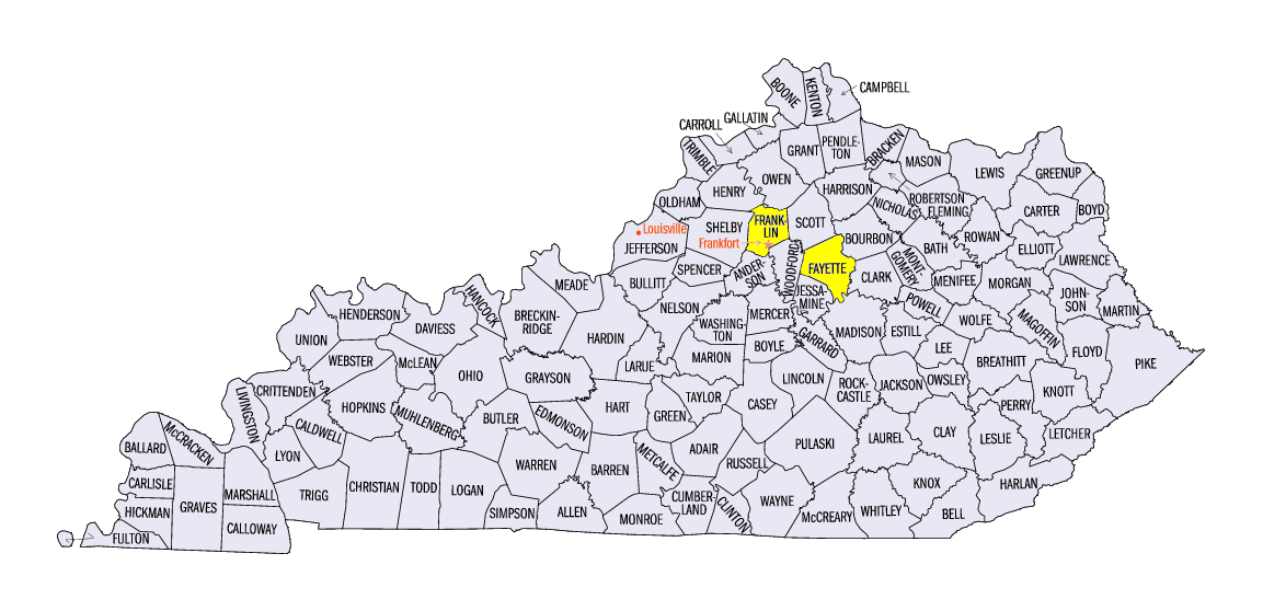
April 2015 precipitation totals range from only 0.1" in northwest Minnesota to 10-12.5" in central Kentucky (Figure 3). April 2015 was the 2nd wettest April on record for Frankfort, KY (Franklin County) and Lexington, KY (Fayette County), after 11.24" and 11.41" (respectively) of rain fell throughout the month. Overall, the preliminary statewide precipitation total for Kentucky is 8.66", which is 4.56" above normal. On the contrary, five states in the Midwest were drier than normal for April. The greatest departures were in Minnesota, which had a statewide value of only 1.39", which is 0.85" below normal. Drought conditions worsened as a result of the dry conditions in Minnesota. In northwest Minnesota, moderate drought intensified to severe drought by the end of the month (Figure 4).
April Snowfall
Snow continued to fall in the upper Midwest throughout the month, with monthly totals topping out at 12.5" to 15" in the Upper Peninsula of Michigan and northern Wisconsin
(Figure 5). These totals were above normal by anywhere from 2" to 10" (Figure 6). A majority of this snow fell during events that occurred during the first and second week of the month.
After Unseasonably Warm Start, April Finishes Cooler than Normal
Overall, April 2015 temperatures were above normal across much of the region, but only by 1°F to 3°F (Figure 7). The month kicked off with unseasonably warm temperatures on April 1st, reaching the 80s in parts of Iowa, Minnesota, and Missouri (Figure 8), which is significantly above normal for April 1st (Figure 9). Unseasonably warm temperatures continued throughout the Midwest the first three weeks of the month (Figure 10), but took a cold turn starting the 22nd (Figure 11). Low temperatures on April 23rd and 24th prompted freeze warnings across Illinois, Indiana, Michigan, and Ohio as freezing temperatures were widespread both mornings. Lows on April 24th were by far the coldest in these areas, dipping to 15°F to 20°F in portions of Michigan and northern Minnesota (Figure 12).
Preliminary statewide temperatures show values close to normal for many states since the warm start and cool end to the month cancel each other out when averaged. Missouri shows the greatest departure from normal, with the statewide April temperature 2.1°F above normal. The other eight Midwest states are within 2°F of normal, and all above normal with the exception of Michigan, which was 0.9°F below normal.
Severe Weather
It was an active month for severe weather in the Midwest, with the most significant event occurring on April 8th and 9th. The two-day severe weather outbreak produced over 700 reports of hail, wind, and tornadoes across the U.S., with many of them in the Midwest (Figure 13). Seven tornadoes moved through north-central Illinois on April 9th, with the most devastating being an EF-4 that went along a 30-mile path from Franklin Grove, IL to Fairdale, IL, killing 2 people and injuring 22 more. More details on this event can be found in the Week 2 Climate Watch summary.
Other notable severe weather events in April included tornadoes in southwest Missouri on April 2nd and 3rd and severe weather in Kentucky on April 25th.
Great Lakes Ice Cover
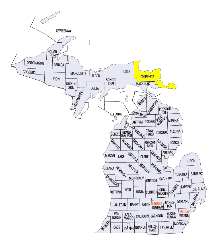
Unseasonably cold temperatures in March meant lingering ice cover on the Great Lakes into April, with the total ice cover at the beginning of the month at 47.6% (Figure 14). Lake Superior in particular still had quite a bit of ice cover at the beginning of the month, with about 60% of the lake ice covered on April 1st (Figure 15). As temperatures warmed up at the start of April, the ice began to break up, causing shipping issues on Lake Superior. In mid-April, wind took huge, free-floating ice chunks to the eastern end of Lake Superior, leaving 18 freighters stuck in the ice. The U.S. and Canadian Coast Guards got involved, sending icebreakers to help the ships break free in Whitefish Bay, which is near Chippewa County in Michigan. Warmer April temperatures reduced ice cover on Lake Superior to around 10% by the end of the month, which is much lower than the end of April last year when ice cover was still around 40% on Lake Superior.
Throughout the month of April, total Great Lakes ice cover decreased by about 42%, with the month-end ice cover at 5.7% (Figure 16). This is lower than the end of April last year when ice cover was still at 23.5%, which lingered as a result of the record-breaking ice cover and cold temperatures throughout the winter and spring of 2014.
-MW-
Extension climatologist for Illinois-Indiana Sea Grant and the Midwestern Regional Climate Center.
Portions of this report were provided by the Iowa Climatology Bureau, NWS Indianapolis, GLERL, the Kentucky Climate Center, and the Missouri Climate Center.