May 8-14, 2016
Midwest Weekly Highlights - May 8-14, 2016
Cold Week in Minnesota
Temperatures were cold across Minnesota, with most of the state 4-7°F below normal for the week
(Figure 1). An arctic air mass invaded the northern half of the region during the latter part of the week, which led to freezing minimum temperatures across Minnesota and near-freezing temperatures in northern Iowa and western Wisconsin through the morning of May 14 (Figure 2). The chill was felt most in the maximum temperatures, as most of Minnesota was 6-10°F below normal
(Figure 3). Maximum temperatures on May 13 through the morning of May 14 were only in the low 40’s across the state (Figure 4). Warmer temperatures were found farther south, however. Missouri and Kentucky experienced average temperatures 2-5°F above normal during the week. The remainder of the region was within a few degrees of normal.
Wet Weather for Many
Multiple large-scale storms moved through the region during the week and led to more than an inch of precipitation for most of the region
(Figure 5). Illinois, Kentucky and parts of Missouri all had more than one-and-a-half inches, while areas near the confluence of the Ohio and Mississippi rivers received upwards of three inches. These areas were more than two inches above normal (Figure 6). Wet weather was also common across western Iowa and southern Lower Michigan, where nearly twice the normal amount of precipitation fell
(Figure 7).
Severe Weather in the Southern Midwest
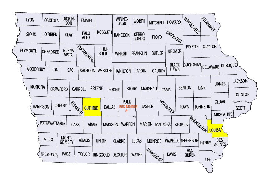
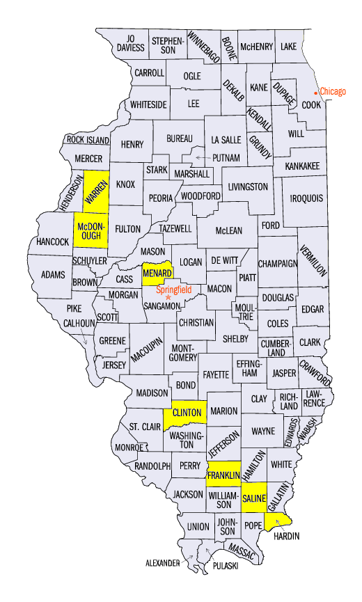
Another active week of severe weather led to many hail, wind and tornado reports across Missouri, southern Illinois and Kentucky (Figure 8). Most of these reports came during the three-day period of May 9-11. Several tornadoes were reported on May 9 in Illinois and Minnesota. A rope tornado was reported in Guthrie County, IA, with weak tornadoes where no damage was reported in McDonough and Warren counties, IL and Louisa County, IA.
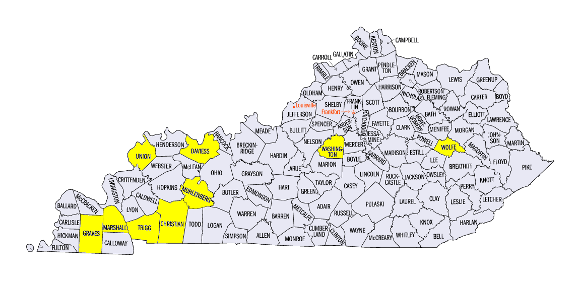
Kentucky was dealt the brunt of severe weather on May 10 as two-inch and greater hail, 60 mph winds and strong tornadoes were common in the state. Two-and-a-half inch hail was reported in Wolfe County, KY and 2.75 inch hail was reported in Muhlenberg County, KY. Two-inch hail was also reported in Daviess and Washington counties, KY. The main story, however, was the EF-3 tornado near Mayfield, KY in Graves County. Winds of up to 140 mph caused damage along a 19-mile path that extended into Marshall County. Ten injuries were reported and fortunately no one was killed. Several EF-0 and EF-1 tornadoes were reported in Kentucky in Christian, Muhlenberg, Union and Trigg counties. Saline, Hardin and Franklin counties in Illinois also had tornado reports.
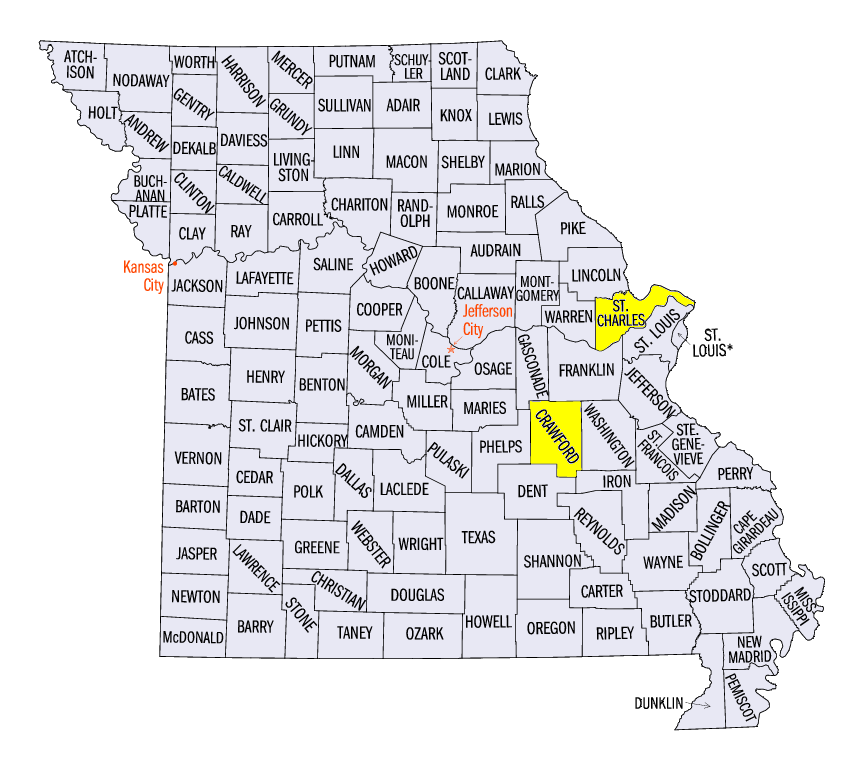
A cluster of hail and wind reports were found in eastern Missouri through central Kentucky on May 11. Baseball- to softball-size hail was reported northwest of St. Louis in St. Charles County, MO. The National Weather Service in St. Louis measured a 4-inch hailstone at their office. Hundreds of car windshields were shattered from the hail at dealerships while siding and roofing on homes were severely damaged. An EF-2 tornado was also reported west of Bourbon in Crawford County, MO. No injuries were reported. Strong winds were reported in Illinois, as wind gusts over 75 mph were reported in Menard and Clinton counties. In total, the region had more than 200 storm reports in the three-day period.
Crop Progress
Midwest farmers continue to make progress planting corn across the region. According the National Agriculture Statistics Service, six of the nine states in the region had more than half of the corn crop planted as of May 8, with five states having more than 70% planted
(Figure 9). In addition, the same six states were more than 20% ahead of the 5-year average for this week (Figure 10). Indiana’s corn crop progress is close to the 5-year average, while Michigan sits at 10% below the 5-year average.
Drought Concerns Stay Low
Despite the end to drought-free conditions in April, drought remained a minor concern for the region. The latest Drought Monitor for May 10 from the National Drought Mitigation Center shows only slightly more than one percent of the region classified in drought (Figure 11). Slightly less than 11% of the region is considered to be abnormally dry as well. However, some concerns are present in Missouri, where a large portion of the state received less than half the normal amount of precipitation during the first half of spring (Figure 12). Over half the state is considered to be abnormally dry, and the only area of moderate drought in the Midwest is located in the south-central portion of the state.
-BJP-