February 8-14, 2015
Midwest Weekly Highlights - February 8-14, 2015
Frigid Temperatures Return
In a stark contrast from the start of February, temperatures shifted well below normal during the period
(Figure 1). A majority of the Mississippi and Ohio River Valleys were 8-14°F below normal. The rest of the region was also below normal, with most of Michigan 2-5°F below normal. Extremely cold temperatures were common through the mornings of February 13 (Figure 2) and February 14
(Figure 3). Parts of northern Minnesota and the U.P. of Michigan had minimum temperatures in the -20s to -30s. The coldest temperature recorded was -39°F at Stambaugh, MI in Iron County on the morning of February 14.
Dry, But Snowy Week
A majority of the region had below-normal precipitation during the period (Figure 4). The entire region had less than an inch of precipitation, while most areas had less than a quarter of an inch
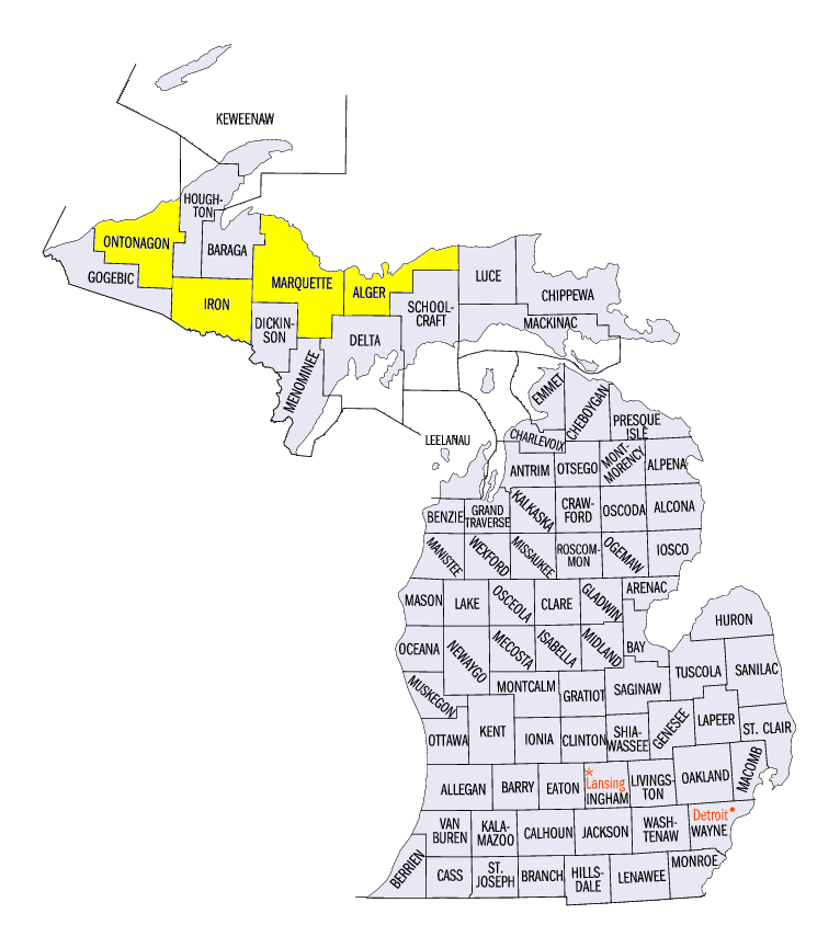
(Figure 5). This resulted in a majority of the region having less than half the normal amount of precipitation (Figure 6). However, parts of the U.P. of Michigan had well above normal precipitation, thanks to lake-effect snow. Over 10 inches of snow fell across the U.P. over the period, with spots receiving over 15 inches
(Figure 7). Green Garden in Marquette County had 19.6 inches, while 19.2 inches fell six miles north of Greenland in Ontonagon County. The highest total was 25.5 inches in Munising in Alger County. Three to six inches of snow also fell across southwest Minnesota, western Iowa, eastern Ohio and parts of Lower Michigan. In many cases, the snow that fell was more than twice the normal amount (Figure 8).
Western Iowa and Minnesota Blizzard February 7-8
High winds coupled with snow led to whiteout conditions and a blizzard warning for western Iowa and southern Minnesota for late in the day on February 7 through February 8. Roads quickly became impassible while accidents were reported. Wind gusts of 40-60 mph were common from the Nebraska and South Dakota border through central Iowa, and in southern Minnesota. This blizzard was accompanied by very little snowfall, as most of the areas in the blizzard had less than an inch of snow over the two day period
(Figure 9). However, more than 6 inches of snow was on the ground at the time (Figure 10).
-BJP-