October 11-17, 2017
Midwest Weekly Highlights - October 11-17, 2017
Warm Weather Remains
Near- to above-normal temperatures remained common across the Midwest
(Figure 1). Areas in the eastern Midwest were the most above normal, with most of Ohio 5-8°F above normal. Indiana, northern Illinois, Lower Michigan and southern Wisconsin were also 3-6°F above normal. Missouri, northern Wisconsin and the U.P. of Michigan were a few degrees above normal, while most of Minnesota and western Iowa were near normal.
Heavy Rain
Several inches of rain fell across northern Illinois and southern Lower Michigan in a wet week (Figure 2). Most of this rain fell through the mornings of October 11
(Figure 3) and October 15 (Figure 4). More than an inch of rain also fell across northern Missouri, eastern Iowa and southern Wisconsin. Many of these areas had more than twice the normal amount, with northern Illinois and southern Lower Michigan receiving more than five times the normal amount
(Figure 5). Several hundred daily precipitation records were broken during the period (Figure 6).
October 14-15 Heavy Rainfall and Severe Weather
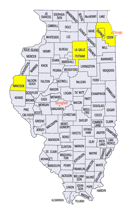
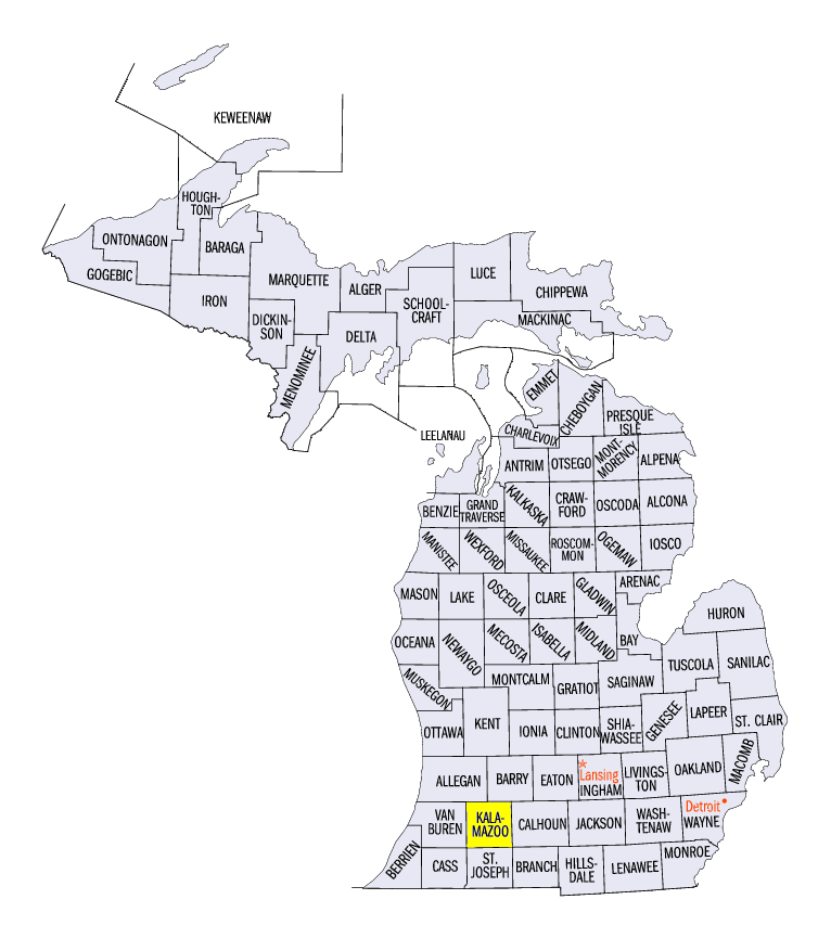
High moisture content in the atmosphere along the warm front of a slow-moving system dropped several inches of rain on northern Illinois and southern Lower Michigan on October 14 through the morning of October 15 (Figure 7). Amounts of 4-7 inches were reported. Some of the heaviest amounts through the morning of October 15 included 7.32 inches near Glen Ellyn, IL (DuPage County), 6.90 inches near Kalamazoo, MI (Kalamazoo County) and 6.75 inches near Earlville, IL (LaSalle County). Several rivers reached flood stage, including major flood stage on the Des Plaines River near Lemont, IL (Figure 8, Cook County) and the DuPage River near Bollingbrook, IL (Figure 9, DuPage County). More than 100 daily precipitation records were broken through the morning of October 15, with many in northern Illinois and southern Lower Michigan (Figure 10).
Severe weather was also a component of this storm system
(Figure 11). Strong thunderstorm winds of 60-65 mph were reported in northern Missouri and central Illinois. Several hail reports were reported near the Illinois, Iowa and Missouri tristate area. Two tornadoes were also reported. An EF-1 tornado touched down near South Gorin, MO and damaged outbuildings and a grain silo. Meanwhile, a brief EF-0 tornado near Bowen, IL (Hancock County) caused damage to several trees.
Harvest Behind Schedule for Many
The 2017 harvest has been complicated during the first two weeks of October due to heavy rain. As of the week ending October 15, all nine Midwest states are behind the five-year average for the corn harvest according to NASS
(Figure 12). Iowa and Minnesota are the furthest behind in the Midwest at around 30 percent behind the five-year average. The soybean harvest in both states were also well behind at more than 30 percent behind the five-year average
(Figure 13). The only state where the soybean harvest was well ahead of schedule was Michigan. Soybeans were 17 percent above the five-year average harvest in the state.
Drought Expands in Missouri, Improves in Iowa, Illinois
While the overall percentage of the Midwest in drought improved, moderate drought expanded in southern Missouri according to the October 17 U.S. Drought Monitor (Figure 14). Areas in south-central Missouri increased the percentage of the state in drought from 20 percent to 25 percent. Meanwhile, heavy rain in Iowa decreased drought and abnormally dry conditions by more than 10 percent. Improvements were also seen in Illinois, where less than half the state was abnormally dry, compared to nearly 90 percent on October 10. Overall, seven percent of the Midwest was in drought, with 5.7 million people estimated to be living in drought affected areas.
-BJP-