July 11-17, 2017
Midwest Weekly Highlights - July 11-17, 2017
Cool in the North
Temperatures were below normal in northern Minnesota, Wisconsin and the U.P. of Michigan during the week
(Figure 1). Some areas in far northern Minnesota and the U.P. of Michigan were more than 5°F below normal. Southern Wisconsin and northern Illinois were also 1-3°F below normal. Several dozen daily low maximum temperature records were set in the northern parts of the region (Figure 2). Warmer weather took place in western Iowa and Missouri, where temperatures were 2-4°F above normal. Parts of Kentucky were also slightly above normal.
Precipitation Extremes
Many areas of the Midwest had either a very dry or a very wet week as summertime thunderstorms rolled through some areas but not others
(Figure 3). Most of Ohio, central Indiana, southern Wisconsin and northern Illinois had more than an inch-and-a-half of rain during the period. Values above three inches were also common. Parts of Indiana and Ohio had more than three times the normal amount (Figure 4). Over 125 daily precipitation records were broken, with most occurring from July 11-14 (Figure 5). However, Kentucky, Iowa and most of Minnesota had only a few tenths of an inch or less of rain. In many cases, this was less than half the normal amount.
July 11-12 Southeastern Wisconsin, Northeastern Illinois Flooding and Flash Flooding
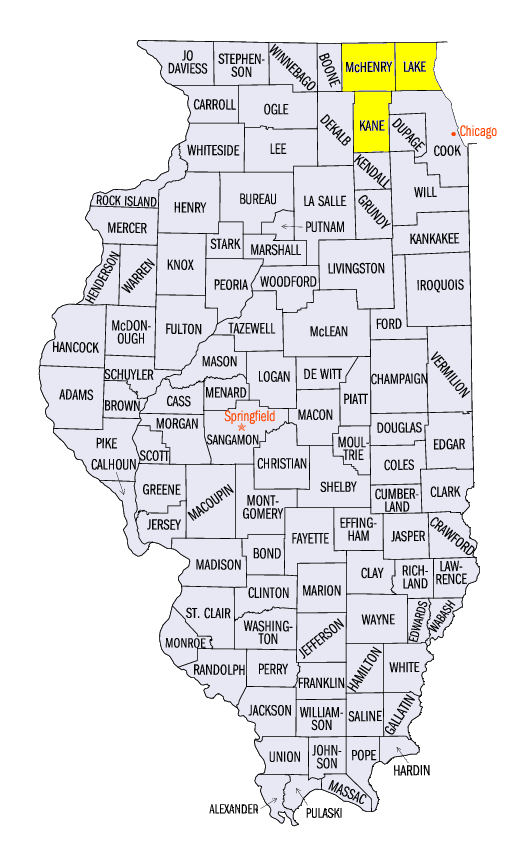
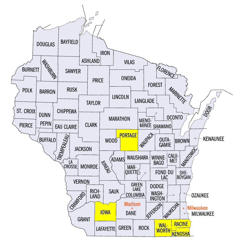
Heavy rain during the overnight hours of July 11 through the morning of July 12 caused flash flooding and flooding in Lake and McHenry counties, IL and Racine, Kenosha and Walworth counties, WI (Figure 6). More than four inches of rain fell in several locations and caused most of the city of Burlington, WI to flood
(Figure 7). A record crest was observed on the Fox River at Burlington, WI (Figure 8) and at New Munster, WI
(Figure 9). Further south, the Des Plaines River near Gurnee, IL (Figure 10) and Russell, IL
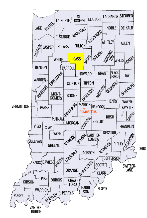
(Figure 11) reached a record crest as well. The major flooding lasted throughout the week. Six Flags Great America in Gurnee, IL was forced to close due to the flooding, and Amtrak suspended service between Chicago and Milwaukee. Thunderstorms further east that night also claimed the life of a 6-year old boy in Galveston, IN (Cass County) who fell into a creek during a flash flood.
More Severe Weather
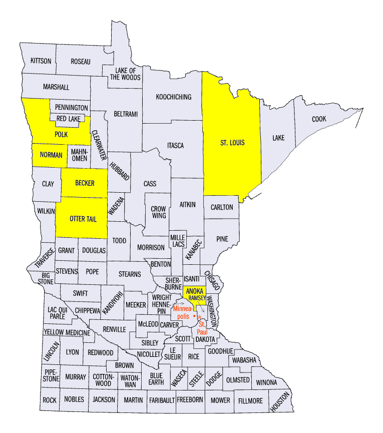
Strong to severe thunderstorms remained common across the Midwest (Figure 12). Severe weather was reported on six of the seven days in the period, and has occurred on 15 of the first 17 days of July. More than 150 of the 280-plus reports were reported on July 11 (Figure 13). Thunderstorms in Minnesota caused large hail, including two-inch hail in Callaway (Becker County) and Fergus Falls (Otter Tail County). Estimated 80 mph wind gust was also observed near Callaway, Detroit Lakes and Frazee, MN (Becker County). Severe thunderstorms also caused wind damage in the Minneapolis/St. Paul area. Storms across eastern Iowa, southern Wisconsin and northern Illinois included a 75 mph wind gust report in Dubuque, IA (Dubuque County), a two-inch hail report in Rewey, WI (Iowa County) and a 78 mph wind gust in Pingree Grove, IL (Kane County). Strong thunderstorm winds were also reported across central Illinois, central Indiana and southwestern Ohio. Several tornadoes were reported during the evening and overnight hours in Iowa and Minnesota. An EF-1 tornado was surveyed near Williamsburg, IA (Iowa County) with estimated winds of 105 mph. Several weak tornadoes occurred near Alvarado, MN (Polk County), near Borup, MN (Norman County), and near Forest Lake, MN (Anoka County).
Scattered wind and large hail reports continued throughout the period. Wind and hail was reported in Iowa, Wisconsin and Michigan on July 12, with an EF-0 tornado near Custer, WI (Portage County). Strong thunderstorm winds were common in eastern Wisconsin on July 15, while large hail fell in northwestern Ohio on July 16. Strong winds and hail were reported in northern Minnesota on July 17, where a 2.5-inch hailstone was found near Biwabik, MN (St. Louis County).
Crops Struggling
An up-and-down growing season across the Midwest has caused corn and soybean crops to struggle across portions of the Midwest. As of the July 16 USDA NASS Crop Condition Report, less than 50 percent of corn and soybeans were rated as good or excellent in Indiana (Figure 14). Crops in Ohio were also struggling at less than 60 percent good or excellent. Only Wisconsin, Minnesota and Kentucky corn, and Minnesota, Kentucky and Iowa soybeans had more than 70 percent of the crop in good or excellent condition. While adequate precipitation has fallen across most of the Corn Belt since April 1, except Iowa and Minnesota (Figure 15), and temperatures have only been slightly above normal since April 1 (Figure 16), the region has experienced many extremes which stressed crops. This included dry and hot stretches in early June and numerous heavy rain events and severe weather, which caused ponding, crop damage and planting delays. The combination of these extremes was likely a contributor to poorer crop conditions.
-BJP-