June 8-14, 2017
Midwest Weekly Highlights - June 8-14, 2017
More Heat
Above-normal temperatures were common across the Midwest for the second straight week
(Figure 1). Only Kentucky and southern portions of Missouri and Ohio were near normal. Most of Iowa, southern Minnesota, Wisconsin, northern Illinois and Lower Michigan were 6-10°F above normal. Maximum temperatures during the week routinely reached the upper 80s to low 90s. The hottest days came near the end of the period, including June 12 (Figure 2) and June 13
(Figure 3). Hundreds of daily high maximum and high minimum temperature records were broken from the heat (Figure 4).
Dry for Many, Stormy in Minnesota and Wisconsin
Dry conditions continued across the southern half of the Midwest
(Figure 5). Most of Missouri, western Illinois and western Kentucky had little to no precipitation throughout the period. While Indiana, Ohio and eastern Kentucky received several tenths of an inch, it was still below the normal amount (Figure 6). Much wetter conditions were common across Minnesota, Wisconsin and the U.P. of Michigan, however. Several rounds of thunderstorms from June 11-14 dropped several inches of rain in areas. In most cases, this was one-and-a-half to two times the normal amount
(Figure 7). Several dozen daily precipitation records were broken as a result, with most in Wisconsin and Minnesota (Figure 8).
Severe Weather
While many areas did not receive adequate precipitation during the week, severe weather affected all nine states in the Midwest region (Figure 9). Only Kentucky recorded a single-digit number of reports, and severe weather was reported on each day in the period except June 8. In total, more than 600 storm reports were recorded from June 9-14, with most of the severe weather occurring on June 11-14.
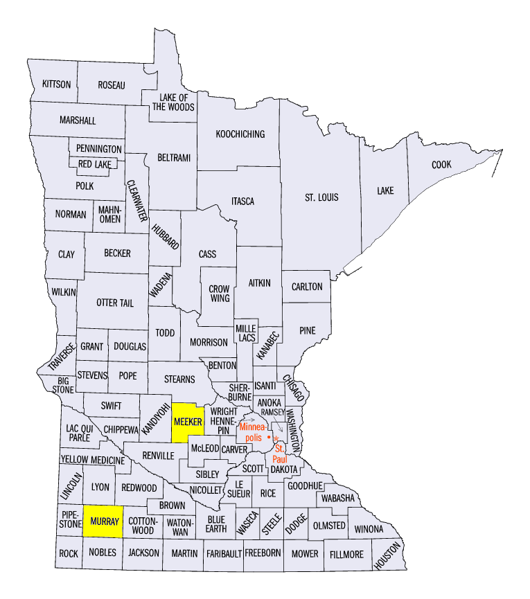
On June 11, a line of thunderstorms formed in the early morning hours across central Minnesota before barreling through northern Wisconsin and across northern Lake Michigan (Figure 10). Most of the reports were for wind damage, but several two-inch hail stones were reported near Slayton, MN (Murray County) and near Somerset, WI (St. Croix County). The strongest wind gust reported was 80 mph near Litchfield, MN (Meeker County). The Minneapolis/St. Paul Airport also recorded a gust of 69 mph.
Strong thunderstorms formed again on June 12 in Wisconsin and southern Minnesota (Figure 11). Wind reports were largely clustered in east-central Wisconsin, where an EF-0 tornado was also surveyed near Campbellsport, WI (Fond Du Lac County).
Strong storms that formed over the High Plains moved into Minnesota and Iowa on June 13 (Figure 12). Many wind and a few tornado reports occurred along the western border of Minnesota. Further east, wind and hail reports were also common across Ohio and parts of Indiana.
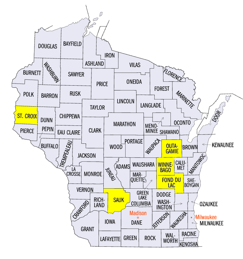
Severe thunderstorms on June 14 caused widespread damage in Wisconsin and northern Illinois
(Figure 13). A 75 mph wind gust was reported near Reedsburg, WI (Sauk County) as a bowing line of thunderstorms marched across eastern Wisconsin. Nine confirmed tornadoes occurred along the line in northeastern Wisconsin. The strongest of these was an EF-1 tornado that paralleled the Fox River near Appleton, WI (Winnebago/Outagamie counties). Five of the nine tornadoes were rated EF-0, while the others were rated EF-1.
Drought Worries Increasing
A dry start to June has worried many farmers across the Midwest about the possibility of a drought. Many areas in the Midwest received less than half the normal amount of rainfall during the first 14 days of the month (Figure 14). According to the June 13 U.S. Drought Monitor, more than a quarter of the Midwest was considered abnormally dry or in drought (Figure 15). Only seven-and-a-half percent was abnormally or in drought the week prior. Moderate drought was introduced in northern Missouri as well, with a minor expansion of moderate drought in northern Minnesota. Topsoil moisture dropped considerably according to NASS, which stressed less established corn and soybeans. A detailed description of conditions can be found in the U.S. Drought Monitor Narrative for June 13.
-BJP-