May 8-14, 2017
Midwest Weekly Highlights - May 8-14, 2017
Warm West, Cool East
Temperatures were divided from east to west during the week
(Figure 1). Most of Minnesota, Iowa and Missouri were 3-5°F above normal, while southern Illinois and western Kentucky were 1-3°F above normal. Further east, Most of Ohio, Michigan and northern Indiana were 3-5°F below normal. Several dozen daily minimum temperature records were broken in the eastern half of the region (Figure 2). Most of these records occurred on the particularly cold mornings of May 8
(Figure 3) and May 9 (Figure 4).
Much Drier
Wet weather finally subsided across the Midwest as most of the region had below-normal precipitation for the week
(Figure 5). Most of Minnesota, Wisconsin and Michigan had less than half the normal amount (Figure 6). Parts of northern Illinois had a wet week however, receiving more than one-and-a-half inches of rain
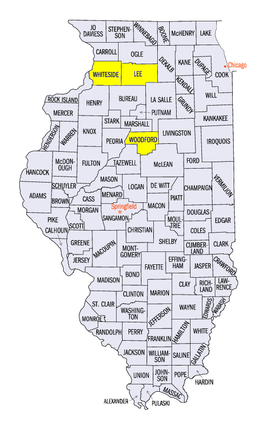
(Figure 7). Some of the highest totals for the week included 2.86 inches in Morrison (Whiteside County) and 2.79 inches near Paw Paw (Lee County).
Flood Waters Recede
With only scattered precipitation during the week, flooding decreased across Missouri, Illinois and Indiana (Figure 8). Only a few gauges in Missouri reported minor flooding by the end of the week, while many gauges along the Mississippi River fell to minor flood stage. Moderate flooding remained common along the Illinois River and on the White and Wabash rivers in southwestern Indiana.
May 10-11 Severe Weather
Several rounds of strong thunderstorms on May 10 and May 11 caused damage across central Illinois, central Indiana and southern Missouri
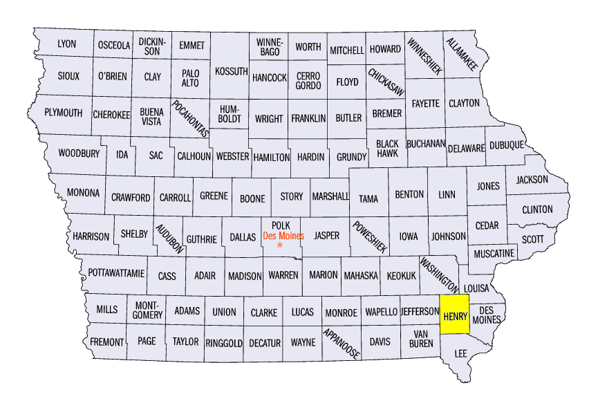
(Figure 9). Storms with strong winds began in southeastern Iowa and continued through central Illinois and Indiana on May 10. Wind gusts up to 70 mph were reported. Several brief tornado touchdowns occurred near Salem, IA (Henry County) and near Washburn, IL (Woodford County). An EF-0 tornado from another batch of thunderstorms touched down just after midnight on May 11 near Neosho, MO (Newton County). These thunderstorms continued during the overnight hours and into the morning of May 11. Quarter-size and larger hail was reported throughout southern Missouri during the morning and afternoon hours.
Planting Season Continues
Corn and soybean planting continued across the Midwest, with Minnesota, Iowa and Missouri having more than 80 percent of corn planted according to the USDA NASS May 14 Crop Progress Report (Figure 10). Corn planting in these three states was above the five-year average. Wisconsin, Illinois, Indiana and Kentucky were all below, but within five percent of the five-year average. Cold weather held back progress in Michigan, where corn and soybean planting was 17 percent and 14 percent below the five-year average, respectively.
Late Spring Freeze Damage in Michigan
Freezing temperatures on the mornings of May 8 and May 9 in Michigan made fruit trees and plants susceptible to freeze damage. While the USDA NASS Michigan Crop Weather Report stated that sprinklers and frost fans were in place for many producers, others had varying amounts of damage. Apple and cherry orchards and blueberry fields that were in bloom and not protected had light to severe damage, while lighter damage was observed in crops that were past bloom.
-BJP-